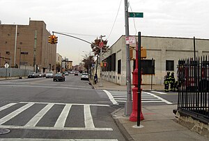
Dyker Heights is a predominantly residential neighborhood in the southwest corner of the borough of Brooklyn in New York City. It is on a hill between Bay Ridge, Bensonhurst, Borough Park, and Gravesend Bay. The neighborhood is bounded by 7th and 14th Avenues, 65th Street, and the Belt Parkway on the west, east, north, and south, respectively.

The Belt Parkway is the name given to a series of controlled-access parkways that form a belt-like circle around the New York City boroughs of Brooklyn and Queens. The Belt Parkway comprises three of the four parkways in what is known as the Belt System: the Shore Parkway, the Southern Parkway, and the Laurelton Parkway. The three parkways in the Belt Parkway are a combined 25.29 miles (40.70 km) in length. The Cross Island Parkway makes up the fourth parkway in the system, but is signed separately.

Windsor Terrace is a small residential neighborhood in the central part of the New York City borough of Brooklyn. It is bounded by Prospect Park on the east and northeast, Park Slope at Prospect Park West, Green-Wood Cemetery, and Borough Park at McDonald Avenue on the northwest, west, and southwest, and Kensington at Caton Avenue on the south. As of the 2010 United States Census, Windsor Terrace had 20,988 people living within its 0.503-square-mile (1.30 km2) area.

Atlantic Avenue is a major thoroughfare in the New York City boroughs of Brooklyn and Queens. It stretches from the Brooklyn waterfront on the East River all the way to Jamaica, Queens. Atlantic Avenue runs parallel to Fulton Street for much of its course through Brooklyn, where it serves as a border between the neighborhoods of Prospect Heights and Fort Greene and between Bedford-Stuyvesant and Crown Heights, and between Brooklyn Heights and Cobble Hill. This stretch of avenue is known for having a high rate of pedestrian fatalities and has been described as "the killing fields of the city."
The BMT Fourth Avenue Line is a rapid transit line of the New York City Subway, mainly running under Fourth Avenue in Brooklyn. The line is served by the D, N, and R at all times; the R typically runs local, while the D and N run express during the day and local at night. During rush hours, select W trains also serve the line. Northbound D and N trains run local along the line after 6:45 p.m. during weekdays as well. The line was originally built by the Brooklyn Rapid Transit Company and is now internally operated as part of the New York City Subway's B Division.

New York State Route 104 (NY 104) is a 182.41-mile-long (293.56 km) east–west state highway in Upstate New York in the United States. It spans six counties and enters the vicinity of four cities—Niagara Falls, Lockport, Rochester, and Oswego—as it follows a routing largely parallel to the southern shoreline of Lake Ontario, along a ridge of the old shoreline of Glacial Lake Iroquois. The western terminus of NY 104 is an intersection with NY 384 in Niagara Falls, Niagara County, while its eastern terminus is a junction with NY 13 in the town of Williamstown, Oswego County. The portion of NY 104 between Rochester and the village of Webster east of the city is a freeway known as the Keeler Street Expressway west of NY 590 and the Irondequoit–Wayne County Expressway east of NY 590; from Williamson to Oswego, NY 104 is a super two highway.

New York State Route 27 (NY 27) is a 120.58-mile (194.05 km) long state highway that runs east–west from Interstate 278 (I-278) in the New York City borough of Brooklyn to Montauk Point State Park on Long Island, New York. Its two most prominent components are Sunrise Highway and Montauk Highway, the latter of which includes the Montauk Point State Parkway. NY 27 acts as the primary east–west highway on southern Long Island east of the interchange with the Heckscher State Parkway in Islip Terrace. The entire route in Suffolk, Nassau, and Queens counties were designated by the New York State Senate as the POW/MIA Memorial Highway. The highway gives access to every town on the South Shore. NY 27 is the easternmost state route in the state of New York, as well as the longest highway on Long Island.

The South Brooklyn Railway is a railroad in the New York City borough of Brooklyn. It is owned by the government of New York City and operated by the New York City Transit Authority. Its original main line ran parallel to 38th Street from the Upper New York Bay to McDonald Avenue, and south on McDonald Avenue to the Coney Island Yards, mostly underneath the former Culver Shuttle and the IND Culver Line of the New York City Subway.
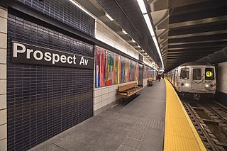
The Prospect Avenue station is a local New York City Subway station on the BMT Fourth Avenue Line in Brooklyn. It is located at Prospect Avenue and Fourth Avenue near the convergence of the Gowanus, Greenwood Heights, Park Slope, and South Park Slope neighborhoods. It is served by the R train at all times. The D and N trains also stop here during late nights, and some rush-hour W trains stop here in the peak direction.
Vanderbilt Avenue is the name of three thoroughfares in the New York City boroughs of Brooklyn, Manhattan, and Staten Island. They were named after Cornelius Vanderbilt (1794–1877), the builder of Grand Central Terminal in Midtown Manhattan.

Coney Island Avenue is a road in the New York City borough of Brooklyn that runs north-south for a distance of roughly five miles, almost parallel to Ocean Parkway and Ocean Avenue. It begins at Brighton Beach Avenue in Coney Island and goes north to Park Circle at the southwest corner of Prospect Park, where it becomes Prospect Park Southwest. Near-parallel Ocean Parkway terminates five blocks south and three blocks west of that intersection, becoming the Prospect Expressway. Ocean Parkway originally extended north to Park Circle, where Coney Island Avenue meets Prospect Park, until construction of the Prospect Expressway replaced the northern half-mile of Ocean Parkway but included ramps to the edge of Prospect Park.

The Fifth Avenue Line, also called the Fifth Avenue Elevated or Fifth Avenue–Bay Ridge Line, was an elevated rail line in Brooklyn, New York City, United States. It ran above Hudson Avenue, Flatbush Avenue, Fifth Avenue, 38th Street, and Third Avenue from Downtown Brooklyn south to Bay Ridge. The portion on Third Avenue was called the Third Avenue Elevated to distinguish service from the elevated BMT West End Line; it was separate from the elevated IRT Third Avenue Line in Manhattan and the Bronx.

Linden Boulevard is a boulevard in New York City. Its western end is at Flatbush Avenue in Brooklyn, where Linden Boulevard travels as an eastbound-only street to Caton Avenue, where it becomes a two-way street. The boulevard stretches through both Brooklyn and Queens. This boulevard, especially the area of Cambria Heights between Springfield Boulevard and the Nassau County line represents a smaller version of shopping centers located on Jamaica Avenue and Queens Boulevard. Linden Boulevard also continues into Nassau County to Valley Stream where it turns into Central Avenue; this was one of several former names of the street in Queens.
The JFK Expressway is a freeway connecting the Belt Parkway with John F. Kennedy International Airport in Queens, New York City. It interchanges with the Nassau Expressway near the originally proposed southern terminus of the Clearview Expressway. The highway is the newest expressway in New York City, with the final section having been completed in December 1991.

White Plains Road is a major north-south thoroughfare which runs the length of the New York City borough of the Bronx. It runs from Castle Hill and Clason Point in the south to Wakefield in the north, where it crosses the city line and becomes West 1st Street of Mount Vernon, New York. The Bronx River Parkway lies to its west and parallels much of its route. Between Magenta Street & 217th Street, White Plains Road is very wide due to the presence of the Gun Hill Road station house in the road's median.
Ocean Avenue is a major street in Brooklyn, New York that runs generally north-south and occupies the position of East 20th Street in the Brooklyn street grid, with East 19th Street to its west and East 21st Street to its east for most of its path. It runs east of and parallel to Ocean Parkway and Coney Island Avenue for most of its route. Except for a short stretch on the Manhattan Beach peninsula, Ocean Avenue starts in the south at Emmons Avenue in Sheepshead Bay just south of the Belt Parkway and continues north, ending at Flatbush Avenue at Willink Plaza after running for several blocks as the eastern edge of Prospect Park. A footbridge across Sheepshead Bay connects the two "Ocean Avenue" sections.

Fourth Avenue is a major thoroughfare in the New York City borough of Brooklyn. It stretches for 6 miles (9.7 km) south from Times Plaza, which is the triangle intersection created by Atlantic and Flatbush Avenues in Downtown Brooklyn, to Shore Road and the Belt Parkway in Bay Ridge.

Rockaway Boulevard is a major road in the New York City borough of Queens. Unlike the similarly named Rockaway Beach Boulevard and Rockaway Freeway, it serves mainland Queens and does not enter the Rockaways.

Fort Hamilton Parkway is a parkway in Brooklyn, New York. It runs for 4.1 miles from the neighborhood of Windsor Terrace to Bay Ridge, its southern end at the entrance to its namesake military base at Fort Hamilton.