
Riverside Park is a scenic waterfront public park in the Upper West Side, Morningside Heights, and Hamilton Heights neighborhoods of the borough of Manhattan in New York City. The park measures 4 miles (6.4 km) long and 100 to 500 feet wide, running between the Hudson River and Henry Hudson Parkway to the west and the serpentine Riverside Drive to the east.

Briarwood is a middle-class neighborhood in the New York City borough of Queens. The neighborhood is roughly bounded by the Van Wyck Expressway to the west, Parsons Boulevard to the east, Union Turnpike to the north, and Hillside Avenue to the south.

Canarsie is a mostly residential neighborhood in the southeastern portion of Brooklyn, New York City. Canarsie is bordered on the east by Fresh Creek Basin, East 108th Street, and Louisiana Avenue; on the north by Linden Boulevard; on the west by Ralph Avenue; on the southwest by Paerdegat Basin; and on the south by Jamaica Bay. It is adjacent to the neighborhoods of East Flatbush to the west, Flatlands and Bergen Beach to the southwest, Starrett City to the east, East New York to the northeast, and Brownsville to the north.

The Cross Island Parkway is a controlled-access parkway in New York City and Nassau County, part of the Belt System of parkways running along the perimeter of the boroughs of Queens and Brooklyn. The Cross Island Parkway runs 10.6 miles (17.1 km) from the Whitestone Expressway in Whitestone past the Throgs Neck Bridge, along and across the border of Queens and Nassau County to meet up with the Southern State Parkway, acting as a sort of separation point which designates the limits of New York City. The road is designated as New York State Route 907A (NY 907A), an unsigned reference route, and bears the honorary name 100th Infantry Division Parkway.

Woodhaven is a neighborhood in the southwestern section of the New York City borough of Queens. It is bordered on the north by Park Lane South and Forest Park, on the east by Richmond Hill, on the south by Ozone Park and Atlantic Avenue, and the west by the Cypress Hills neighborhood of Brooklyn.

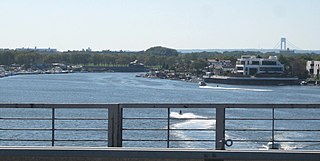
Broad Channel is a neighborhood in the southern portion of the New York City borough of Queens. It occupies the southern portion of Rulers Bar Hassock, the only inhabited island in Jamaica Bay.

Jamaica Hills is a small middle class neighborhood in the New York City borough of Queens. The neighborhood is surrounded by Hillcrest, Jamaica Estates, Jamaica, and Briarwood. It is centered on the terminal moraine that runs the length of Long Island. Originally populated with people who left neighborhoods under ethnic transition, Jamaica Hills started to become more ethnically diverse after 1964. The population today is very mixed with a large South Asian population and smaller populations from the Caribbean, Central America, and China. Because of the opening of a Greek Orthodox church in the 1960s, many Greek immigrants also live in the area. Jamaica Hills is patrolled by the New York City Police Department's 107th Precinct.

Fresh Meadows is a neighborhood in the northeastern section of the New York City borough of Queens. Fresh Meadows used to be part of the broader town of Flushing and is bordered to the north by the Horace Harding Expressway and Auburndale; to the west by Pomonok, St. John's University, Hillcrest, and Utopia; to the east by Cunningham Park and the Clearview Expressway; and to the south by the Grand Central Parkway.

Interstate 678 (I-678) is a north–south auxiliary Interstate Highway that extends for 14 miles (23 km) through two boroughs of New York City. The route begins at John F. Kennedy International Airport on Jamaica Bay and travels north through Queens and across the East River to the Bruckner Interchange in the Bronx, where I-678 ends and the Hutchinson River Parkway begins.
Mill Basin is a residential neighborhood in southeastern Brooklyn, New York City. It is on a peninsula abutting Jamaica Bay and is bordered by Avenue U on the northwest and the Mill Basin/Mill Island Inlet on its remaining sides. Mill Basin is adjacent to the neighborhood of Bergen Beach to the northeast, Flatlands to the northwest, Marine Park to the southwest, and Floyd Bennett Field and the former Barren Island to the southeast. Mill Basin also contains a subsection called Old Mill Basin, north of Avenue U.
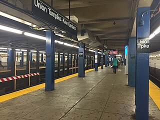
The Kew Gardens–Union Turnpike station is an express station on the IND Queens Boulevard Line of the New York City Subway. Located at Union Turnpike and Queens Boulevard on the border of Kew Gardens and Forest Hills, Queens, it is served by the E and F trains at all times, and the <F> train during rush hours in the reverse peak direction. Despite the station's name, Union Turnpike forms the border between Kew Gardens and Forest Hills, and the station straddles that border, with multiple entrances located in each neighborhood.
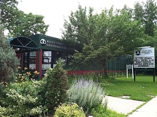
Alley Pond Park is the second-largest public park in Queens, New York City, occupying 655.3 acres (265.2 ha). The park is bordered to the east by Douglaston, to the west by Bayside, to the north by Little Neck Bay, and to the south by Union Turnpike. The Cross Island Parkway travels north-south through the park, while the Long Island Expressway and Grand Central Parkway travel east-west through the park. The park primarily consists of woodlands south of the Long Island Expressway and meadowlands north of the expressway. It is run and operated by the New York City Department of Parks and Recreation.

Jamaica Estates is a neighborhood in the New York City borough of Queens. Jamaica Estates is part of Queens Community District 8 and located in the northern portion of Jamaica. It is bounded by Union Turnpike to the north, Hillside Avenue to the south, Utopia Parkway and Homelawn Street to the west, and 188th Street to the east. The main road through the neighborhood is Midland Parkway.

Union Turnpike is a thoroughfare stretching across part of Long Island in southern New York state, mostly within central and eastern Queens in New York City. It runs from Myrtle Avenue in Glendale, Queens, to Marcus Avenue in North New Hyde Park, Nassau County, about 1 mile (1.6 km) outside New York City border.

The Q17 bus route constitutes a public transit line in Queens, New York City, running primarily along Kissena Boulevard, the Long Island Expressway service road and 188th Street between two major bus-subway hubs in the neighborhoods of Jamaica and Flushing. It is one of the busiest local bus routes in Queens. Operated by the North Shore Bus Company until 1947, the route is now operated by MTA Regional Bus Operations under the New York City Transit brand.
Spring Creek, previously called Spring Creek Basin, is a neighborhood within the East New York section of Brooklyn in New York City. It roughly comprises the southern portions of East New York between Flatlands Avenue to the north, and Jamaica Bay and the Gateway National Recreation Area to the south, with the Brooklyn neighborhood of Canarsie to the west and the Queens neighborhood of Howard Beach to the east. It is named after Spring Creek, one of several creeks that formerly ran through the area and drained into Jamaica Bay.
Mapleton is a neighborhood in southern Brooklyn, New York City, bounded by 16th Avenue on the west, Dahill Road on the east, 57th Street on the north, and 65th Street on the south. It borders Bensonhurst and Borough Park to the west, and Midwood to the east.

Calvert Vaux Park is an 85.53-acre (34.61 ha) public park in Gravesend, Brooklyn, in New York City. Created in 1934, it is composed of several disconnected sections along the Belt Parkway between Bay 44th and Bay 49th Streets. The peninsula upon which the park is located faces southwest into Gravesend Bay, immediately north of the Coney Island Creek. The park was expanded in the 1960s by waste from the construction of the Verrazzano-Narrows Bridge, and was renamed after architect Calvert Vaux in 1998. It is operated by the New York City Department of Parks and Recreation, also known as NYC Parks.

Bowne Park is a 11.79-acre (4.77 ha) park in Broadway–Flushing, Queens, New York, east of downtown Flushing. It is bordered by 29th Avenue on the north, 32nd Avenue on the south, 155th Street on the west, and 159th Street on the east. The park consists of a playground, basketball courts, bocce court, and a kettle pond. The area immediately surrounding the park, developed in the late 19th and early 20th centuries, was originally also marketed as "Bowne Park" and is part of modern-day Murray Hill and Broadway–Flushing.

Captain Tilly Park is a 9.16-acre (3.71 ha) park in Jamaica Hills, Queens, New York, north of downtown Jamaica. It is bordered by 165th Street to the west, 85th Avenue to the north, Chapin Parkway and Gothic Drive to the northeast, and Highland Avenue to the south. The park consists of a kettle pond named Goose Pond, the only remaining kettle pond in Jamaica Hills.

