Ghazni is one of the 34 provinces of Afghanistan, located in eastern Afghanistan. The province contains 19 districts, encompassing over a thousand villages and roughly 1.3 million people, making it the 5th most populous province. The city of Ghazni serves as the capital. It lies on the important Kabul–Kandahar Highway, and has historically functioned as an important trade center. The Ghazni Airport is located next to the city of Ghazni and provides limited domestic flights to Afghanistan's capital, Kabul.

This is a list of districts of Afghanistan, known as wuleswali. These are secondary level administrative units, one level below the provinces. The Afghan government issued its first district map in 1973. It recognized 325 districts, counting wuleswalis (districts), alaqadaries (sub-districts), and markaz-e-wulaiyat. In the ensuing years additional districts have been added through splits, and a few eliminated through mergers. In June 2005, the Afghan government issued a map of 398 districts. It was widely adopted as by many information management systems, though usually with the addition of Sharak-e-Hayratan for a 399 district total. Here is a link to a clean rendering of the 399 district set as a spreadsheet from an official Afghan source. It remains the de facto standard, as of late 2018, despite a string of government announcements of the creation of new districts.
Jaghori is one of the main districts of the Ghazni province in Afghanistan. It is located in the highlands in the southern fringes of the Hazaristan region. It occupies 1,855 km2. in the upper Arghandab valley. The population is estimated to be around 560,000 in 2015. The district capital, Sange-e-Masha, is where major business transactions take place. The district is heavily dependent on agriculture, and migrant workers as the main sources of income. Other major marketplaces are in Ghojor, Hotqol and Anguri.

Qarabagh District is located 50 kilometers north of Kabul City in Afghanistan, and 20 kilometers southeast of Bagram Airbase. The district is part of Kabul Province and is on the route between Kabul and Parwan Province. It has a population of 15,000, with an expected 19,000 more people to return from Pakistan and Iran in the future. As of 2002 around 60% of the population are Tajiks and 40% Pashtuns.

Nawur is the largest district in Afghanistan's Ghazni Province by area. Its population, which is entirely Hazara, was estimated at 91,778 in 2002. The Jikhai River originates here. Nawur with 5234 square kilometre is located in northern part of Ghazni Province, Nawur is neighbour with Qarabagh District in south, Jaghuri District, Malistan District and Ajristan District (Daya) in south west, Jaghatu District and Rashidan District in east, Miramor District of Daikundi province in west, Waras District of Bamian Province in north west, Behsud District, Daimirdad District and Jeghatu District of Maidan Wardak Province in north.
Malistan is a district in the west of Ghazni Province, Afghanistan. Its population, which is 100% Hazara, was estimated at 350,000 in 2009. The district capital is Mir Adina.
Nawa is a large district in the far south of Ghazni Province, Afghanistan. It is 100 km south from Ghazni in a mountainous region. The salt lake Ab-i Istada is located in the northern part of the district. Nawa's population, which is 100% Pashtun, was estimated at 29,054 in 2002, of whom around 45% were children under 12. The district center is the village of Nawa. Military operations in the district were featured in articles in the Washington Post and the New York Times in October 2009. The district was controlled by the Taliban until 17 July 2017.
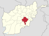
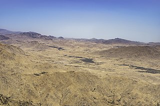
Qarabagh, is a district 56 km to the south-west of Ghazni in eastern Afghanistan. The 1,800 km2 area is one of the most populated at 109,000; some reports count more than 218,000. The ethnic composition of the district includes Hazaras and Pashtuns. The landscape varies in different parts of the district - deserts in the southwest, plains in the southeast and mountains in the north. The district is seriously affected by drought, especially farming and animal husbandry. Health and education need serious improvement.

Andar is one of the eastern districts of Ghazni Province in Afghanistan. The population has been estimated at 88,300, all Pashtun. The district center is Miray while the other main town is Andar. The district is named after the Andar Ghilji tribe of the Pashtuns. The district also contains the town of Sardeh Band on its edge near the border with Paktika Province.
Deh Yak is a rural district in the eastern part of Ghazni Province, Afghanistan, 30 km east from the city of Ghazni. The district has an area of 715 km2, containing 66 villages and a population of about 44,386. Ramak serves as the district's headquarters.
Zana Khan district is a mountainous district in Ghazni Province, Afghanistan with more than 12,000 people living there. The district center is Dado.
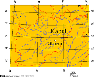
Ghazni District is a district of Ghazni Province, Afghanistan situated in the northeast part of the province. Capital of the district is Ghazni, which is also capital of Ghazni Province.
Qara Bagh is a town and the center of Qarabagh District, Kabul Province, Afghanistan. The population is 13,000. The town was seriously damaged during the wars.
Ramazan Bashardost is Afghanistan's former planning minister, a current member of the National Assembly of Afghanistan and was an independent candidate in the 2009 Afghan presidential election.
Karabakh is a geographic region in present-day eastern Armenia and southwestern Azerbaijan, extending from the highlands of the Lesser Caucasus down to the lowlands between the rivers Kura and Aras
Tamaki is a village in the Qarabagh District of Ghazni Province in Afghanistan, very close to Jaghori District. Tamaki is populated by Hazara people. The 10,000 to 15,000 people in Tamaki speak either Hazaragi or Dari and their religion is Shia Islam. Tamaki village has places called Taqchin, Qol, warqa, Nala, Blandqash and Qani and the center place is called Deh Raazi which is in Qani place. More than 1500 students are studying in four high schools in Tamaki village, two schools for boys and two schools for girls as called Tawhid Tamaki, and Mostalat Taqchin Tamaki.
Task Force White Eagle is a brigade sized detachment of Polish Land Forces in Ghazni Province, Afghanistan. The brigade is under the command of the US 1st Cavalry Division. 30 October 2008 Polish forces taking over responsibility for Ghazni province. Throughout the activity of the Polish contingent in Afghanistan occurred fighting with the Taliban and other rebels. Polish troops took part in many military operations. During the mission 44 Polish soldiers were killed.
Sher Khan Nashir was the hereditary Grand Khan of the Nashir clan of the Kharoti (Ghilji) tribe and governor (Wali) of Northern Afghanistan in the 1930s, known as the "father of Kunduz. He was apparently poisoned by the King of Afghanistan. Many places, schools and Afghanistan's largest port Sher Khan Bandar are named after him.

A mountainous country, Afghanistan contains many notable valleys. The majority of the valleys are located in parts of northeastern, central, southern and southeastern Afghanistan. The southeastern areas are wetter and are covered by forest with trees such as cypress, oak, poplar, pine etc.

Qōlyāqōl is a valley and a residential area in Afghanistan located in Qarabagh of Ghazni Province in the Hazaristan region of Afghanistan in central parts of the country.