
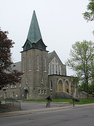
Maniwaki is a town in the province of Quebec, Canada. It is situated 130 kilometres (81 mi) north of Ottawa, Ontario, on the Gatineau River, at the crossroads of Route 105 and Route 107, near Route 117. The town is the administrative centre for La Vallée-de-la-Gatineau Regional County Municipality.
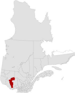
La Vallée-de-la-Gatineau is a regional county municipality in the Outaouais region of western Quebec, Canada. The seat is in Gracefield. It was incorporated on January 1, 1983 and was named for its location straddling the Gatineau River north of Low.
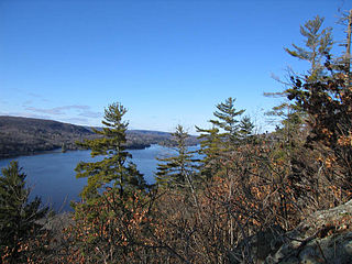
The Gatineau River is a river in western Quebec, Canada, which rises in lakes north of the Baskatong Reservoir and flows south to join the Ottawa River at the city of Gatineau, Quebec. The river is 386 kilometres (240 mi) long and drains an area of 23,700 square kilometres (9,200 sq mi).
Area codes 819, 873, and 468 are overlay telephone area codes in the North American Numbering Plan (NANP) for central and western Quebec, Canada, including the Quebec portion of the National Capital Region, and the Hudson Strait and Ungava Bay coastlines of Quebec. Major cities in the territory include Gatineau, Sherbrooke, Trois-Rivières, Drummondville, Shawinigan, Victoriaville, Rouyn-Noranda, Val-d'Or, Magog and Mont-Laurier.
Chelsea is a municipality located immediately north of Gatineau, Quebec, Canada, and about 10 kilometres (6.2 mi) north of Ottawa. Chelsea is located within Canada's National Capital Region. It is the seat of Les Collines-de-l'Outaouais Regional County Municipality.

The Hull–Chelsea–Wakefield Railway was a 33 km (20.5 mi) heritage railway in Quebec, Canada, running tourist trains through the scenic Gatineau Hills and beside the Gatineau River between Hull and the tourist town of Wakefield from May to October, using a 1907 Swedish steam locomotive, E2 class number 909, and 1940s-built Swedish passenger cars. On average, the railway attracted about 50 000 tourists and generated revenues of about $8 million for the region.
Autoroute 5 is a short controlled-access Autoroute in the Outaouais region of western Quebec. It connects the central urban area of Gatineau with the recreational areas of Gatineau Park and the exurban rural areas of Chelsea and La Pêche. The southern terminus provides access to the Macdonald-Cartier Bridge, which continues into downtown Ottawa. The A-5 generally has four lanes of traffic with the exception of southernmost section across the Macdonald-Cartier Bridge where A-5 widens to six lanes.
Autoroute 50 is an Autoroute in western Quebec, Canada. It links Canada's National Capital Region (Gatineau) and the Greater Montreal area (Mirabel).
Boulevard Saint-Joseph is a commercial boulevard in the former city of Hull, Quebec. It runs from Boulevard Alexandre-Taché to the boundaries of the Gatineau and the suburban town of Chelsea.

Route 148 is an east-west highway in Quebec, Canada. It runs from junction of Autoroute 13 and Autoroute 440 in Laval in the Montreal region to the Ontario-Quebec border in L'Isle-aux-Allumettes in western Quebec. For most of its length, Route 148 follows the north shore of the Ottawa River where it acted as the principal route between communities in the Outaouais region until the completion of Autoroute 50 in 2012. At the Ontario-Quebec border in L'Isle-aux-Allumettes Route 148 continues into Ontario as Highway 148.
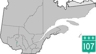
Route 107 is a north/south highway on the north shore of the Saint Lawrence River. Its southern terminus is in Maniwaki at the junction of Route 105 and its northern terminus is in Grand-Remous at the junction of Route 117.

Route 117, the Trans Canada Highway Northern Route, is a provincial highway within the Canadian province of Quebec, running between Montreal and the Quebec/Ontario border where it continues as Highway 66 east of McGarry, Ontario. It is an important road since it is the only direct route between southern Quebec and the Abitibi-Témiscamingue region.
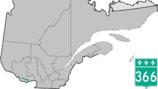
Route 366 is a secondary highway in the Outaouais region of Quebec. It runs from Route 301 near Creemorne in the Pontiac to Route 148 in the city of Gatineau.

Route 307 is a provincial road located in the Outaouais region of Quebec. The road runs mostly parallel to the Gatineau River on the eastern side of it. It starts at the corner of Rue Saint-Louis and Boulevard Greber in the Gatineau sector of the city of Gatineau. It runs north of Gatineau and ends in Val-des-Bois at the junction of Route 309 which runs from the Buckingham sector north into the Upper Laurentians.

Route 309 is a provincial highway located in the Outaouais region in western Quebec. It starts at the junction of Autoroute 50 in the Buckingham sector, in the city of Gatineau's east end. It runs mostly parallel to the Du Lièvre River and ends north of Mont-Laurier in the town of Sainte-Anne-du-Lac in the Upper Laurentians.

Route 301 is an 81.1-kilometre-long (50.4 mi) provincial highway located in the Outaouais region in western Quebec. The route serves as a direct connection between the Pontiac region and the Upper Gatineau region. The 82-kilometer route runs from the end of Ontario Highway 653 near Portage-du-Fort and joins Route 148 for a 9 km (5.6 mi) stretch up to Campbell's Bay where it continues eastward and ends in Kazabazua at the junction of Route 105.
Grand-Remous is a town and municipality in La Vallée-de-la-Gatineau Regional County Municipality, Quebec, Canada. The municipality is south of the Baskatong Reservoir, spanning both sides of the Gatineau River. The town is situated at the intersection of Route 117 and Route 105.
Western Québec School Board is an English-language school district based in Gatineau, Quebec, Canada. It was formerly a Protestant school district. The chairperson is Wayne Daly, and the director general is George Singfield.
The Chemin de fer de l'Outaouais, (CFO) or the Compagnie de chemin de fer de l'Outaouais (CCFO) is a railroad that linked the city of Gatineau to Wakefield, in the province of Quebec. Before 1986 the track extended to Maniwaki.
The Centre de services scolaire des Hauts-Bois-de-l'Outaouais (CSSHBO) is a school service centre that offers educational services for about 3,000 people in Outaouais, Quebec. It provides 19 primary schools, three secondary schools, and two vocational schools, as well as an adult education centre providing general training at three sites. It covers a territory the size of Belgium that includes the Valleys of Gatineau and Pontiac, whose principal urban centres are Maniwaki, Gracefield, Fort-Coulonge, and Shawville.


