Quebrada del Condorito National Park

Last updated

Quebrada del Condorito National Park
Parque Nacional Quebrada del Condorito
IUCN category II (national park)

Balcon Sur-Condoritos 069.jpg

Andean condors over the park's Balcón Sur
Relief Map of Argentina.jpg
Red pog.svg
Location within Argentina
Location Córdoba Province, Argentina
Nearest city Alta Gracia
Coordinates 31°40′S64°40′W / 31.667°S 64.667°W / -31.667; -64.667 Coordinates: 31°40′S64°40′W / 31.667°S 64.667°W / -31.667; -64.667
Area 37,344 ha (373.44 km2; 144.19 sq mi)
Established November 28, 1996 (1996-11-28) [1]
Governing body Argentine National Parks Administration

Quebrada del Condorito National Park (Spanish : Parque Nacional Quebrada del Condorito) is a federal protected area in Córdoba Province, Argentina. Established on 28 November 1996, [1] it houses a representative sample of the Sierras Pampeanas biodiversity in endangered state of conservation. It has an area of 37,344 ha (373.44 km2; 144.19 sq mi)

Spanish language Romance language

Spanish or Castilian is a Romance language that originated in the Castile region of Spain and today has hundreds of millions of native speakers in the Americas and Spain. It is a global language and the world's second-most spoken native language, after Mandarin Chinese.

Argentina federal republic in South America

Argentina, officially the Argentine Republic, is a country located mostly in the southern half of South America. Sharing the bulk of the Southern Cone with Chile to the west, the country is also bordered by Bolivia and Paraguay to the north, Brazil to the northeast, Uruguay and the South Atlantic Ocean to the east, and the Drake Passage to the south. With a mainland area of 2,780,400 km2 (1,073,500 sq mi), Argentina is the eighth-largest country in the world, the fourth largest in the Americas, and the largest Spanish-speaking nation. The sovereign state is subdivided into twenty-three provinces and one autonomous city, Buenos Aires, which is the federal capital of the nation as decided by Congress. The provinces and the capital have their own constitutions, but exist under a federal system. Argentina claims sovereignty over part of Antarctica, the Falkland Islands, and South Georgia and the South Sandwich Islands.

Sierras Pampeanas mountain range

The Sierras Pampeanas is a geographical region of Argentina.

Contents

History

Thousands of years ago members of the archaeologically-missing Ayampitín Culture frequented these uplands, establishing temporary camps for hunting guanaco, pampas deer and the large mammals once abundant here.

Guanaco species of mammal

The guanaco is a camelid native to South America, closely related to the llama. Its name comes from the Quechua word huanaco. Young guanacos are called chulengos.

Pampas deer A species of mammals belonging to the deer, muntjac, roe deer, reindeer, and moose family of ruminants

Pampas deer is a species of Deer that live in the grasslands of South America at low elevations. They are known as venado or gama in Spanish and as veado-campeiro in Portuguese. Their habitat includes water and hills, often with winter drought, and grass that is high enough to cover a standing deer. Many of them live on the Pantanal wetlands, where there are ongoing conservation efforts, and other areas of annual flooding cycles. Human activity has changed much of the original landscape. They are known to live up to 12 years in the wild, longer if captive, but are threatened due to over-hunting and habitat loss. Many people are concerned over this loss, because a healthy deer population means a healthy grassland, and a healthy grassland is home to many species, some also threatened. Many North American birds migrate south to these areas, and if the Pampas deer habitat is lost, they are afraid these bird species will also decline. There are approximately 80,000 Pampas deer total, with the majority of them living in Brazil.

Mammal class of tetrapods

Mammals are vertebrate animals constituting the class Mammalia, and characterized by the presence of mammary glands which in females produce milk for feeding (nursing) their young, a neocortex, fur or hair, and three middle ear bones. These characteristics distinguish them from reptiles and birds, from which they diverged in the late Triassic, 201–227 million years ago. There are around 5,450 species of mammals. The largest orders are the rodents, bats and Soricomorpha. The next three are the Primates, the Cetartiodactyla, and the Carnivora.

When the Spaniards arrived in the sixteenth century, the Comechingones inhabited the region.

Description

Although located near the city of Cordoba and tourist towns like Villa Carlos Paz, Alta Gracia, Tanti, Mina Clavero, etc., the territory of the park has remained scenically pristine due to its inaccessibility. Extensive ranching, however, has been practiced since colonial times, resulting in intense erosion to the vegetation cover due to cattle trampling on the sandy, steep-sloped soil.

Córdoba, Argentina City in Córdoba, Argentina

Córdoba is a city in the geographic center of Argentina, in the foothills of the Sierras Chicas on the Suquía River, about 700 km (435 mi) northwest of the Buenos Aires. It is the capital of Córdoba Province and the second most populous city in Argentina after Buenos Aires, with about 1,330,023 inhabitants according to the 2010 census. It was founded on 6 July 1573 by Jerónimo Luis de Cabrera, who named it after Córdoba, Spain. It was one of the first Spanish colonial capitals of the region that is now Argentina. The National University of Córdoba is the oldest university of the country and the seventh to be inaugurated in Spanish America. It was founded in 1613 by the Jesuit Order. Because of this, Córdoba earned the nickname La Docta.

Villa Carlos Paz City in Córdoba, Argentina

Villa Carlos Paz is a city in the center-north of the province of Córdoba, Argentina, in the south of the Punilla Valley, lying on the western slope of the Sierras Chicas. It has a population of about 56,000 as per the 2001 census [INDEC]. The area of Punilla is a major tourist destination on the national level, and Villa Carlos Paz is in turn the most important city of Punilla, favoured by its closeness to the populous Córdoba City, the capital of the province. Popular tourist activities include bathing in one of the many rivers, fishing, evening shows, kite surfing, windsurfing, hiking and mountain biking.

Alta Gracia City in Córdoba, Argentina

Alta Gracia is a city located in the north-centre of the province of Córdoba, Argentina. Its name means "High Grace". It is built upon the Sierras Chicas, in a region that the Comechingón Indians used to call Paravachasca. It has about 43,000 inhabitants.

The boundaries of the park are:

Camino de las Altas Cumbres highway in Argentina

In the last years of the 1950s, it became clear that there was a need to modernize the old Suspension bridges road in the province of Córdoba, Argentina. Increasing traffic and trade between the provinces of Cordoba Mendoza and San Juan needed new roads to expedite travelling times and decrease costs. At the same time, it was considered important to create a route linking the ports of the Atlantic with the Pacific through the Cordoba corridor.

The climate in the area is mountain temperate, becoming increasingly colder with height, and with a marked temperature difference between day and night and between summer and winter. During the winter (May to early August), snowfall is rather common. Another characteristic phenomenon is the frequent lightning strikes at the higher elevations.

There are hiking trails and bike paths of different lengths and degrees of difficulty, most of them signaled. There are several areas of rough camping (no services) with access to drinking water. Considering the adverse environmental and topographical factors, visitors are advised to consult the Argentine National Parks Administration in order to safely enjoy the wild and lonely landscape.

Biodiversity

The Carancho, a large bird of prey inhabiting the park. Caracara Quebrada del Condorito.jpg
The Carancho, a large bird of prey inhabiting the park.

Quebrada del Condorito lies within the high altitude of the top floor of the Sierras Grandes, which contrasts with the great Pampas' lower plains that surround them. This gives the region characteristics of a biological island, which, depending on climatic variations, is enriched by intermittent flows of Andean and Patagonian wildlife colonization. As a result, the area has a great diversity of endemic species and subspecies, both plants and animals.

The park is an important site for Andean condors watching (the species had undergone a marked population decline during the twentieth century), for which the easternmost distribution is found in this region. Recently developed policies for condor protection, active caring and reintroduction into wildlife have led to a steep recovery of populations where they had been almost extinguished a few years ago.

Related Research Articles

Tourism in Argentina

Argentina is provided with a vast territory and a huge variety of climates and microclimates ranging from tundra and polar in the south to the tropical climate in the north, through a vast expanse of temperate climate and natural wonders like the Aconcagua, the highest mountain in the world outside the Himalayas, the widest river and estuary of the planet, the huge and very mighty Iguazú Falls, some of the flattest and wide meadows-plains of planet Earth, culture, customs and gastronomies famous internationally, a higher degree of development, good quality of life and people and relatively well prepared infrastructure make this country one of the most visited of America.

Sierras de Córdoba mountains in Argentina

The Sierras de Córdoba is a mountain range in central Argentina, located between the Pampas to the east and south, the Chaco to the north and the foothills of the Andes to the west. Almost the entire range, except for the southwestern margin in San Luis Province, is located in Córdoba Province.

Talampaya National Park national park of Argentina

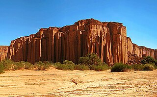
Talampaya National Park is a national park located in the east/centre of La Rioja Province, Argentina. It was designated a provincial reserve in 1975, a national park in 1997, and a UNESCO World Heritage Site in 2000.

Calilegua National Park national park

The Calilegua National Park is a federal protected area in Jujuy Province, Argentina. Established on 19 July 1979, it houses a representative sample of the Southern Andean Yungas biodiversity in good state of conservation.

El Leoncito National Park paisaje

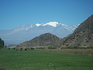
El Leoncito National Park is a federal protected area in San Juan Province, Argentina. Established on 18 September 2002, it houses a representative sample of the Central Andean Puna and the Southern Andean steppe biodiversity in good state of conservation, as well as historical and paleontological sites. It has an area of 89,706 ha

Ichigkat Muja – Cordillera del Condor National Park National Park in Peru

The Ichigkat Muja – Cordillera del Condor National Park is a protected area in Peru located in the region of Amazonas. It protects part of the Eastern Andes forests at the Cordillera del Condor mountain range.

Perito Moreno National Park national park

Perito Moreno National Park is a national park in Argentina. It is located in the western region of Santa Cruz Province on the border with Chile. It has an area of 126,830 hectares of mountains and valleys at a height of 900 metres above sea level.

Pampa de Achala mountain range in Argentina

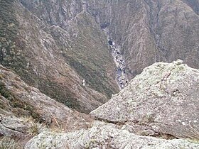
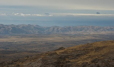
Pampa de Achala is the name given to a vast region that lies at the heart of the Sierras de Córdoba located within Sierras Pampeanas, and located in central-northwest of Argentina. It is a rugged area with little vegetation, which is over 1,500 m having distinctive species, ecology, relief and hydrography. The region is protected by provincial law, and that this region basin is head of the vast majority of streams that run through the Córdoba.

San Guillermo National Park national park

San Guillermo National Park is a national park in Argentina, in the Iglesia Department of San Juan Province. It was established in 1998 and is part of the San Guillermo Biosphere Reserve. Elevations in the biosphere range from 2,100 metres (6,900 ft) to 6,380 metres (20,930 ft). Vegetation in the National Park and biosphere consists of barren desert, grasslands, and a few wetlands, all located in the high, arid Andes. The animals include vicuña, guanaco, culpeo fox, Andean mountain cat, cougar, and Andean condor.

Sierra de las Quijadas National Park national park

The Sierra de las Quijadas National Park is a national park located in the northwestern part of the Argentine province of San Luis. It was established on December 10, 1991, to protect the natural features, representative of the Semiarid Chaco and the Argentine Low Monte ecoregions.

Campos del Tuyú National Park national park

Campos del Tuyú National Park is a national park in Buenos Aires Province, Argentina. Situated on the southern shore of Samborombón Bay, the park was established on May 13, 2009. The main attraction of Campos del Tuyú is the rare pampas deer; in fact, it is one of the few places in the Pampas where this species survive. Other inhabitants of the park include over a hundred bird species, capybara, and the likewise endangered Leopardus geoffroyi.

Tamá National Natural Park protected area

The Tamá National Natural Park is a national park located in the Tamá Massif of the Andean Region of Colombia, between the municipalities Toledo and Herrán, in the department of Norte de Santander, in the northeastern part of the Eastern Ranges of the Colombian Andes. One of the main attractions of the park is a 820-metre-high (2,690 ft) waterfall, one of the world's highest.

Puracé National Natural Park Protected area in Colombia

The Puracé National Natural Park is a national park located in the Andean Region of Colombia, southeast of the city of Popayán in the Cordillera Central range. Its main feature is the active stratovolcano Puracé, one of Colombia's most active volcanoes. Four of the country's most important rivers originate within the area: Magdalena River, Cauca River, Japurá River and Patía River.

Valle de Traslasierra

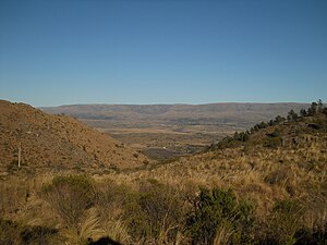
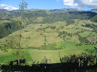
Traslasierra Valley is a natural geographic region of the province of Córdoba, Argentina, located west of the Sierras Grandes and east of the Sierras Occidentales. The tourist capital is the city of Mina Clavero and the most important commercial center is the city of Villa Dolores.

Tren de las Sierras

Tren de las Sierras is a regional 150.8 km (93.7 mi) regional rail line in Córdoba Province of Argentina. The line runs from Alta Córdoba to Cosquín, being currently operated by state-owned company Trenes Argentinos.

Sierra La Culata National Park

The Sierra La Culata National Park Also Sierra de la Culata National Park is a national park of Venezuela that is located in the northeastern branch of the Venezuelan Andes, in the states Mérida and Trujillo. It was decreed a national park on December 7, 1989. It has a high mountain climate, with temperatures ranging between −2 and 24 °C, and its surface area is 200,400 hectares (774 sq mi).

References

  1. 1 2 Ley No. 24749, 6 de enero de 1997, B.O., (28557), 1  (in Spanish); prom.: 28 de noviembre de 1996