
The Magellanic subpolar forests are a terrestrial ecoregion of southernmost South America, covering parts of southern Chile and Argentina, and are part of the Neotropical realm. It is a temperate broadleaf and mixed forests ecoregion, and contains the world's southernmost forests.

Santa Cruz Province is a province of Argentina, located in the southern part of the country, in Patagonia. It borders Chubut Province to the north, and Chile to the west and south, with an Atlantic coast on its east. Santa Cruz is the second-largest province of the country, and the least densely populated in mainland Argentina.

The Perito Moreno Glacier is a glacier located in Los Glaciares National Park in southwest Santa Cruz Province, Argentina, and originated in the Magallanes Region in Chile. It is one of the most important tourist attractions in the Argentine Patagonia.

The Lago Puelo National Park is a national park of Argentina, located in the northwest of the province of Chubut, in the Patagonia region of South America. It has an area of 276.74 square kilometres. It was created to protect its scenic landscape and the Valdivian flora to augment that of the nearby Los Alerces National Park. Originally an annex to Los Alerces, it was declared a National Park and independent reserve in 1971.
Viedma Lake is a Patagonian lake in the province of Santa Cruz, Argentina, situated near its border with Chile. Measuring approximately 50 miles in length, it is a major elongated trough lake formed from melting glacial ice. Viedma Lake is the second largest perennial lake located entirely within Argentina.

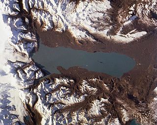
Lago Argentino is a lake in the Patagonian province of Santa Cruz, Argentina, at 50°2′S72°4′W. It is the largest freshwater lake in Argentina, with a surface area of 1,415 km2 (546 sq mi). It has an average depth of 155 m (509 ft), and a maximum depth of 500 m (1,640 ft).

El Calafate, also known as Calafate, is a city in Patagonia, Argentina. It is situated on the southern border of Lake Argentino, in the southwest part of the Santa Cruz Province, about 320 kilometres (200 mi) northwest of Río Gallegos. The name of the city is derived from a little bush with yellow flowers and dark blue berries that is very common in Patagonia: the calafate ; the word comes from the word calafate, which is Spanish for 'caulk'.

The Southern Patagonian Ice Field, located at the Southern Patagonic Andes between Chile and Argentina, is the world's second largest contiguous extrapolar ice field. It is the bigger of two remnant parts of the Patagonian Ice Sheet, which covered all of southern Chile during the last glacial period, locally called the Llanquihue glaciation.

Torres del Paine National Park is a national park encompassing mountains, glaciers, lakes, and rivers in southern Chilean Patagonia. The Cordillera del Paine is the centerpiece of the park. It lies in a transition area between the Magellanic subpolar forests and the Patagonian Steppes. The park is located 112 km (70 mi) north of Puerto Natales and 312 km (194 mi) north of Punta Arenas. The park borders Bernardo O'Higgins National Park to the west and the Los Glaciares National Park to the north in Argentine territory. Paine means "blue" in the native Tehuelche (Aonikenk) language and is pronounced PIE-neh. It was established as a National Park in 1959.

Bernardo O'Higgins National Park is the largest of the protected areas in Chile, covering an area of 3,525,901 ha, in both the Aysén and Magallanes and Antártica Chilena regions. Management of this and other national parks in Chile is entrusted to the Corporación Nacional Forestal (CONAF). The park is named after General Bernardo O'Higgins, the first head of state of the Republic of Chile. Los Glaciares National Park (Argentina) and Torres del Paine National Park are its neighbours to the east, Laguna San Rafael National Park is located to the north, the Alacalufes National Reserve to the southwest, and the Katalalixar National Reserve to the northwest.

The Patagonian Desert, also known as the Patagonian Steppe, is the largest desert in Argentina and is the 8th largest desert in the world by area, occupying 673,000 square kilometers (260,000 mi2). It is located primarily in Argentina and is bounded by the Andes, to its west, and the Atlantic Ocean to its east, in the region of Patagonia, southern Argentina. To the north the desert grades into the Cuyo Region and the Monte. The central parts of the steppe are dominated by shrubby and herbaceous plant species albeit to the west, where precipitation is higher, bushes are replaced by grasses. Topographically the deserts consist of alternating tablelands and massifs dissected by river valleys and canyons. The more western parts of the steppe host lakes of glacial origin and grades into barren mountains or cold temperate forests along valleys.

Tortel is a Chilean commune located at the outflow of the Baker River and Pascua River to the Pacific Ocean. It lies between the Northern and Southern Patagonian Ice Field in the Capitán Prat Province in the Aysén Region. The commune is administered by the municipality in Caleta Tortel, the principal settlement.
Perito Moreno National Park is a national park in Argentina. It is located in the western region of Santa Cruz Province on the border with Chile. It has an area of 126,830 hectares of mountains and valleys at a height of 900 metres above sea level.

Viedma Glacier is a large glacier that is part of the huge Southern Patagonian Ice Field, located at the southern end of mainland South America. Viedma Glacier is a valley glacier and its moraine-rich terminus flows into the western end of Lake Viedma, which is fed primarily by its melting ice. Viedma Glacier is located in the undefined part of the limit between Chile and Argentina, in Argentinian legislature it is in Los Glaciares National Park which was declared a World Heritage Site in 1981. in Chilean legislature part of it is in Bernardo O'Higgins National Park. The Southern Patagonian Ice Field is 13,000 square kilometres (5,000 sq mi); Viedma Glacier is one of the Ice Field's 48 outlet glaciers that have more than 20 square kilometres (7.7 sq mi) of ice field area each.
Monte León National Park is a federal protected area in Santa Cruz Province, Argentina. Established on 20 October 2004, it houses a representative sample of the steppe and Patagonian coast biodiversity in good state of conservation, as well as several paleontological sites of high value. It runs along 36 km (22 mi) of the southern Argentine Sea coastline.

Nahuel Huapi National Park is the oldest national park in Argentina, established in 1922 as Parque Nacional de Sud and reconfiguered in 1934. It surrounds Nahuel Huapi Lake in the foothills of the Patagonian Andes. The largest of the national parks in the region, it has an area of 7,050 km2 (2,720 sq mi), or nearly 2 million acres. Its landscapes represent the north Patagonian Andean Zone consisting of three types, namely, the Altoandino, the Andino-Patagónico and the Patagonian steppe. It also represents small parts of the Valdivian Rainforest.

The Patagonian grasslands (NT0804) is an ecoregion in the south of Argentina and Chile. The grasslands are home to diverse fauna, including several rare or endemic species of birds. There are few protected areas. The grasslands are threatened by overgrazing by sheep, which supply high-quality merino wool. Efforts are being made to develop sustainable grazing practices to avoid desertification.
Cerro Murallón is a glacier mountain of the Andes, in Patagonia, located on the eastern edge of the Southern Patagonian Ice Field, southwest of Lake Viedma, at the border between Chile and Argentina.
Onelli Bay is a bay of Argentino Lake, Santa Cruz Province, Argentina, within Los Glaciares National Park. It is made up of a Patagonian forest and a tributary of Lake Onelli flows into it, into which the Onelli, Agassiz, Bolados and Heim Glaciers also flow.


