Tierra del Fuego National Park

Last updated

Tierra del Fuego National Park
Parque Nacional Tierra del Fuego
Escalonadas Lakes.jpg
Relief Map of Argentina.jpg
Red pog.svg
Location Tierra del Fuego Province, Argentina
Nearest city Ushuaia
Coordinates 54°50′S68°30′W / 54.833°S 68.500°W / -54.833; -68.500
Area630 km2 (243 sq mi)
Established15 October 1960
Governing body Administración de Parques Nacionales

Tierra del Fuego National Park (Spanish : Parque Nacional Tierra del Fuego) is a national park on the Argentine part of the island of Tierra del Fuego, within Tierra del Fuego Province in the ecoregion of Patagonic Forest and Altos Andes, a part of the subantarctic forest. Established on 15 October 1960 under the Law 15.554 [1] and expanded in 1966, it was the first shoreline national park to be established in Argentina. [2]

Contents

The park has dramatic scenery, with waterfalls, forests, mountains, and glaciers. Its 630 km2 (240 sq mi) include parts of the Fagnano and Roca lakes. The Senda Costera (Coastal Path), connecting Ensenada Bay to Lapataia Bay on Lago Roca, is a popular hiking trail within the park. Forests of Antarctic beech, lenga beech, and coihue in the lower elevations of the park are home to many animal species. There are 20 species of terrestrial mammals, including the guanaco, Andean fox, North American beaver, European rabbit and muskrat. Among the 90 species of birds are the kelp goose, torrent duck, austral parakeet, Andean condor, blackish oystercatcher, and Magellanic oystercatcher. [3] [4] [5] [6]

The southernmost national park in Argentina, [4] it is listed as an IUCN category II park. [3] [7] [8] The park stretches 60 km (37 mi) north from the Beagle Channel along the Chilean border. Ushuaia, the capital of Tierra del Fuego Province, is 11 km (6.8 mi) from the park. [6] [9] The park can be reached by car or by train. The southern terminus of the Pan-American Highway is located within the park, as is the El Parque station of the End of the World Train.

Tierra del Fuego National Park, Argentina Parque Nacional Tierra del Fuego, Argentina.jpg
Tierra del Fuego National Park, Argentina

Geography

The park forms the southern portion of the subantarctic forest and is known for its biological richness. [10]

Flora

The subantarctic forest vegetation is dominated by tree species of coihue, nires, and lenga (a tree or shrub native to the Andes and also known as lenga beech) apart from a profusion of massbed. [8] The flora that characterizes the "Andino-Patagonico" forests, the lenga, is well distributed over the mountain slopes above sea level to a height of 600 m (2,000 ft). Above 600 m (2,000 ft) elevation, the flora consists of altoandina with small little bushes, plants en cojin and grasses. [7]

IUCN has reported forests of southern beech species of Nothofagus pumilio , N. antarctica and N. betuloides . Other species include Berberis buxifolia , Embothrium coccineum , winter's bark Drimys winteri , and Crowberry, Empetrum rubrum and mosses. [3] Magellan coihue (coihue de Magallanes) is found in the wettest parts of the Beagle channel coast of the park. Lenga is found in the Pipo River Valley and some parts of southern mountain slopes and may be thickly set and reach great heights. [2] [11] Chinese lantern, hemiparasite and Pande Indian or Llao Llao, which are fungus parasites, are found over the branches of the trees. Cinnamon is also reported in many small forest areas of the park. [7] Peat bogs are extensively found in the park. These are made up of sphagnum moss and aquatic grasses in damp valleys where low temperatures and slow-moving acidic waters prevent decomposition. [4]

The flower varieties found are calafate, chaura and michay, which are orange coloured. Flag tree, strawberry devil and little ferns, yellow orchids and luzuriagas are seen in the understory of forest cover. Black bush, caulking, grill, and Embothrium cocci with red tubular flowers are typically seen in the Beagle Channel coast and the western part of Lapataia Bay. [7] Also found is the chocolate scented Nassauvia . [12]

Fauna

Settlers from Europe and North America introduced many species of animals into the area, such as the European rabbit, North American beaver, and muskrat, which rapidly proliferated and caused significant damage to the environment. [7] [8] [13]

Avifauna includes three types of cauquenes (sheldgeese) namely, cauquen comun (upland goose or Magellan goose), cauquen real (ashy-headed goose) and caranca (kelp goose [5] ), found in open places and beaches. Other birds include Patagonian woodpeckers, notably the spectacular Magellanic woodpecker (maca común, common maca), heron, pato creston (crested duck). Andean condors are seen flying on the peaks and valleys of Tierra del Fuego. [7] It is also home to the austral parakeet (Enicognathus ferrugineus), the southernmostly distributed species of parrot. [14]

Aquafauna consists of scallop, moon snail, spiral tooth, few crustaceans like crabs and fishes such as sardines, Falkland sprat, Fueguina, merluza and Robalo de cola, jellyfish concentrations, steamer ducks and cormorants. [7] Guanaco (Lama guanicoe) and South American sea lions are reported in the park. [3]

Sea birds reported include petrels and albatrosses. Other notable fauna reported are several species of penguins, the South Andean deer (Hippocamelus bisulcus), and the southern river otter (Lontra provocax). [3]

Features

Tierra del Fuego National Park contains mountains, lakes, rivers, and valleys. It is bounded on the west by the Chilean border, on the north by Lago Fagnano, and on the south by the Beagle Channel, which forms the shoreline. It encompasses an area of 63,000 hectares (160,000 acres) and represents two ecoregions: the Altos Andes and the Patagonian Forest. While the former ecoregion is made up of hill ranges and slopes, the latter has high and jagged mountains, glacier valleys, and semi-deciduous forests. The landscape of the park is the result of glacial erosion, which has created bays and beaches against a backdrop of rugged mountains and valleys. [3] [7] [15]

Beagle Channel in Ushuaia Beagle Channel seen from Tierra del Fuego National Park.jpg
Beagle Channel in Ushuaia

The park is located 11 km (6.8 mi) to the west of the city of Ushuaia, on National Road 3. [16] Ushuaia provides the main approach to the park through the highway or through the Southern Fuegian Railway. [17]

Beagle Channel

The Beagle Channel or strait in Tierra del Fuego National Park is named after the British ship HMS Beagle , which sailed with the naturalist Charles Darwin aboard in 1833–34. [18] The channel separates islands of the Tierra del Fuego Archipelago, in extreme southern South America. It separates Isla Grande de Tierra del Fuego from the islands of Nueva, Picton, Navarino, Hoste, Londonderry, Stewart, and other smaller islands to the south. It is oriented in an east-west direction, and runs for a length of 150 mi (240 km). Its width varies from 3 to 8 mi (4.8 to 12.9 km). The biggest settlement on the channel is Ushuaia in Argentina followed by Puerto Williams in Chile, two of the southernmost settlements in the world. [19] [20] Ancient middens where Yaghan tribes lived are seen on the beaches around the Beagle Channel. [4]

Lago Fagnano

Lago Fagnano Hualo.jpg
Flower at Fagnano's lake.jpg
Left: Lago Fagnano. Right: flowers on the shores of the lake

Lago Fagnano (named after the Salesian monk José Fagnano [21] ), also known as Cami Lake, the southernmost lake of its size outside Antarctica, is the largest lake in Tierra del Fuego and flows southward along the eastern slope of the Andean Cordillera of Patagonia into the Magellan Strait through the Azopardo River. [22] It is hemmed in the active tectonic plate (linked to the Magallanes-Fagnano fault) boundary between the South American and Scotia plates. [23] Its East-West orientation in the southern part of Isla Grande de Tierra del Fuego encompasses the national territories of Argentina and Chile; [22] only a small part of the lake lies in Chile. [21] Its evolution is attributed to constant glaciation during the late Pliocene and Pleistocene era. The lake has a total drainage area of 3,042 km2 (1,175 sq mi) with basin elevation ranging from 27 m (89 ft) at the lake level to about 1,000 m (3,300 ft). The lake water spreads over an area of about 645 km2 (249 sq mi), with an average width of 6 km (3.7 mi) (maximum width is 10 km (6.2 mi) over a length of 104 km (65 mi) long and the maximum recorded depth is 204 m (669 ft), with an average depth reported as 70 m (230 ft). Its water volume is 1,000 km3 (240 cu mi). [22]

Climate

The park experiences a temperate climate with frequent rain, fog, and strong winds. Westerly winds over the sea maintain a uniform climate in the park. The average annual rainfall is 700 mm (28 in). Peak rainfall (snowfall at higher elevations) occurs from March through May; no dry season exists. Average temperatures are about 0 °C (32 °F) in winter and 10 °C (50 °F) in the summer. [7] At Ushuaia, the recorded mean annual temperature reported is 5.4 °C (41.7 °F) with maximum monthly mean of 14.2 °C (57.6 °F) and minimum of −10.4 °C (13.3 °F). [3]

History

Period impression of HMS Beagle navigating along Tierra del Fuego, 1833 HMS Beagle by Conrad Martens.jpg
Period impression of HMS Beagle navigating along Tierra del Fuego, 1833

Etymology

The first Europeans who came to explore the southern tip of South America saw the campfires of the native inhabitants of the area (the Yaghan people, also called Yámana). The Spanish explorers hence named the area "Tierra del Fuego", meaning "land of the fires" in Spanish. [9] [24]

Pre-Columbian

Humans inhabited Tierra del Fuego as far back as 10,000 years ago. [25] The Yaghan people, living in the harsh environment, survived on the natural resources of the sea. They lived on its beaches and made voyages into the sea in canoes made of lenga beech, hunted sea lions, and collected shellfish. They lived in huts made of tree branches and trunks and clothed themselves with leather made from sea lion pelts. They smeared their body with the fat and grease of these animals to waterproof their skins. [4]

The southern group of the Selk’nam, the Yaghan people (also known as Yámana), occupied what is now Ushuaia, living in continual conflict with the northern inhabitants of the island.

Post-Columbian

Wasti H. Stirling, an Anglican missionary, settled here in 1870 and started to convert Yaghan tribes, the natives, the original residents of the Beagle Channel.

During the 1880s, many gold prospectors came to Ushuaia, following rumors of large gold fields, which proved to be false.

Trouble for the Yaghan people began in 1880 when European missionaries entered the area. European settlers brought diseases such as measles, causing a rapid and nearly complete extinction of the Yaghan people. The Yaghan tribe was reduced in number from about 3,000 people in 1880 to less than 100 by the 1990s.[ citation needed ] Many of them were killed by European settlers' "shoot exercises" and deliberate poisoning to exploit the sea lions, the staple of the Yaghan diet. [7] [8] Following the deaths of 84-year-old Emelinda Acuña (1921 – 12 October 2005) and her sister Cristina Calderón (1928 - 2022) of Villa Ukika on Navarino Island, Chile, no native speakers remain. [26] What can be seen of the Yaghan people and their settlements today are mainly relics in the form of piles of mussel shells overgrown with grass near the seashore. Some antiquarian links with the tribals can also be seen in the "End of the World Museum" in Ushuaia. [8]

The Boundary Treaty of 1881 was an attempted resolution of the territorial dispute between Argentina and Chile, and stipulated that the boundary between the two countries would run south from "Cape Espiritu Santo, on the northern shore of Tierra del Fuego till it touches the Beagle Channel". This division meant that Argentina would be entitled to the eastern portion while Chile would have the western part of the Tierra del Fuego. However, the Treaty did not clarify the terminus of the Beagle Channel, which created many territorial and collateral issues such as navigation rights. This resulted in a dispute between the two countries, particularly on the small islands (Picton, Lennox, and Nueva) up to Cape horn. The dispute, which started in 1840, almost resulted in war between the two countries in 1978. However, the issue was resolved with the intervention of the Vatican. The Pope ruled on the dispute, ratification ensued and a treaty was signed on 2 May 1985. Under this treaty, Chile retained control of all the disputed islands, and Argentina was entitled to navigational rights and maintained its limited presence on these islands. [20]

After an Argentine naval base was established in 1884, the island was divided between Argentina and Chile. [27]

Argentinian President Roca established a penal colony in 1902, on nearby Staten Island, which resulted in its development. Prisoners were the main workforce and were employed to construct the city and exploit the forests of the now Tierra del Fuego National Park. The train lines were also built by the prisoners, covering an area of 25 km (16 mi), which started from the Maipú Monte Susana camp and ran through the park. [16] [27] The city is now an important tourist center as the departure point not only for the park but also for voyages to Antarctica. [17]

Following the establishment of a prison in Ushuaia, in late 1909 and early 1910 the railway line called the Southern Fuegian Railway or the End of the World train was established as a narrow gauge steam railway, replacing an old wood track railway drawn by bullocks. The steam engine-driven railway was built over a length of 25 km (16 mi) along the Maipu Avenue on the waterfront, followed the eastern slope of Mount Susana, and branched through the middle of the Pipo River valley into the Tierra del Fuego National Park. The line made with Decauville tracks of 500 mm (20 in) gauge, connected the prison camp with the forestry camp. The primary purpose of the railway was as a freight line to serve the prison of Ushuaia, and hence was known as the "Prison train," and was used specifically to transport prisoners to the camps and transport the logged timber from forests. The prison was closed in 1947, and the railway was finally closed in 1952, following the reduction in forest resources and an earthquake that damaged the tracks.

Tourism

There are several attractions within the park including the Beagle Channel, the Pipo River cascade, the Lago Fagnano, Lago Roca, the Ensanada Bay, the Lapataia Bay, the End of the World Train, and the Laguna Negra. [8]

End of the World train

Southern Fuegian Railway in winter Cruzada en La Macarena.jpg
Southern Fuegian Railway in winter

In 1994, 40 years after it had been closed as a Prison train, the train was revived, refurbished with modern amenities, used as a heritage train, and claimed to be the southernmost functioning railway in the world. A new 2-6-2T steam locomotive (Camila, brought from England in 1995), another made in Argentina, and three diesel locomotives serve on the line. [16] The park can now be reached from the outskirts of Ushuaia from the Fin del Mundo station (8 km (5.0 mi) west of Ushuaia) by the heritage railway line and runs over 5 km (3.1 mi), covering the distance in about 50 minutes. [28]

See also

Related Research Articles

<span class="mw-page-title-main">Tierra del Fuego</span> Archipelago off the south of South America

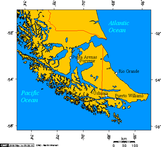
Tierra del Fuego is an archipelago off the southernmost tip of the South American mainland, across the Strait of Magellan.

<span class="mw-page-title-main">Geography of Argentina</span> Geographic features of Argentina

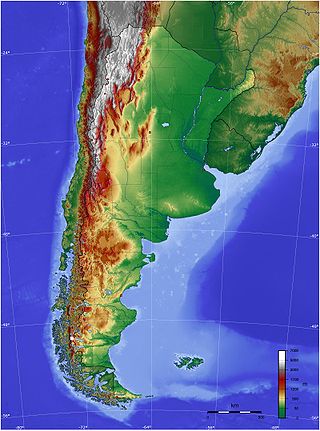
The geography of Argentina is heavily diverse, consisting of the Andes Mountains, pampas, and various rivers and lakes. Bordered by the Andes in the west and the South Atlantic Ocean to the east, its neighbouring countries are Chile to the west, Bolivia and Paraguay to the north, and Brazil and Uruguay to the northeast.

<span class="mw-page-title-main">Strait of Magellan</span> Strait in southern Chile between the Atlantic and Pacific

The Strait of Magellan, also called the Straits of Magellan, is a navigable sea route in southern Chile separating mainland South America to the north and Tierra del Fuego to the south. The strait is considered the most important natural passage between the Atlantic and Pacific oceans. It was navigated by canoe-faring indigenous peoples including the Kawésqar for thousands of years. The strait is approximately 570 km long and 2 km wide at its narrowest point. In 1520, the Spanish expedition of Ferdinand Magellan, after whom the strait is named, became the first Europeans to discover it.

<span class="mw-page-title-main">Ushuaia</span> City in Tierra del Fuego, Argentina

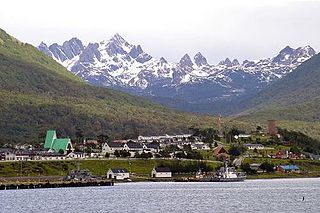
Ushuaia is the capital of Tierra del Fuego, Antártida e Islas del Atlántico Sur Province, Argentina. With a population of 82,615 and a location below the 54th parallel south latitude, Ushuaia claims the title of world's southernmost city.

<span class="mw-page-title-main">Ushuaia – Malvinas Argentinas International Airport</span> Airport in Argentina

Ushuaia – Malvinas Argentinas International Airport is located 4 km (2.5 mi) south of the center of Ushuaia, a city on the island of Tierra del Fuego in the Tierra del Fuego Province of Argentina.

<span class="mw-page-title-main">Tierra del Fuego Province, Argentina</span> Province in Ushuaia, Argentina

<span class="mw-page-title-main">Isla Grande de Tierra del Fuego</span> Island of Argentina and Chile

Isla Grande de Tierra del Fuego also formerly Isla de Xátiva is an island near the southern tip of South America from which it is separated by the Strait of Magellan. The western portion (61.4%) of the island is in Chile, while the eastern portion is in Argentina. It forms the major landmass in an extended group of islands or archipelago also known as Tierra del Fuego.

<span class="mw-page-title-main">Southernmost settlements</span> Worlds most southerly settlements

Southernmost settlements are cities, towns, weather stations or permanent military bases which are farther south than latitude 45°S. They are closely related to the Southern Ocean or either the Roaring Forties or Furious Fifties. Antarctic bases are excluded due to not having a permanent population.

<span class="mw-page-title-main">Puerto Williams</span> City in Magallanes y Antártica Chilena Region, Chile

Puerto Williams is a city, port and naval base on Navarino Island in Chile, and is also the southernmost peopled settlement in the world. It faces the Beagle Channel. It is the capital of the Chilean Antarctic Province, one of four provinces in the Magellan and Chilean Antarctica Region, and administers the communes of Chilean Antarctic Territory and Cabo de Hornos. It has a population of 2,874, including both naval personnel and civilians. Puerto Williams claims the title of world's southernmost city. The settlement was founded in 1953, and was first named Puerto Luisa. The town was later named after John Williams Wilson, a British man who founded Fuerte Bulnes, the first settlement in the Strait of Magellan. It has served primarily as a naval base for Chile. The Chilean Navy runs the Guardiamarina Zañartu Airport and hospital, as well as nearby meteorological stations. Since the late 20th century, the number of navy personnel has decreased in Puerto Williams and the civilian population has increased. In that period, tourism and support of scientific research have contributed to an increase in economic activity.

<span class="mw-page-title-main">Beagle Channel</span> Strait in Tierra del Fuego

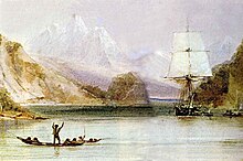
Beagle Channel is a strait in the Tierra del Fuego Archipelago, on the extreme southern tip of South America between Chile and Argentina. The channel separates the larger main island of Isla Grande de Tierra del Fuego from various smaller islands including the islands of Picton, Lennox and Nueva; Navarino; Hoste; Londonderry; and Stewart. The channel's eastern area forms part of the border between Chile and Argentina and the western area is entirely within Chile.

<span class="mw-page-title-main">Hoste Island</span> Island in southern Chile

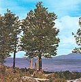
Hoste Island is one of the southernmost islands in Chile, lying south, across the Beagle Channel, from Isla Grande de Tierra del Fuego and west of Navarino Island, from which it is separated by the Murray Channel. It is named after William Hoste, one of Lord Nelson's protégés. Hoste Island has the southernmost trees on earth, Nothofagus antarctica. In Magellania, Jules Verne described an imaginary republic on the island.

<i>Nothofagus pumilio</i> Species of plant

Nothofagus pumilio, the lenga beech, is a deciduous tree or shrub in the Nothofagaceae family that is native to the southern Andes range, in the temperate forests of Chile and Argentina to Tierra del Fuego, from 35° to 56° South latitude. This tree is in the same genus as the coihue. It regenerates easily after fires. The wood is of good quality, moderate durability, and is easy to work with. It is used in furniture, shingles and construction and sometimes as a substitute for American black cherry in the manufacturing of cabinets.

<span class="mw-page-title-main">Puerto Toro</span> Place in Magallanes y Antártica Chilena, Chile

Puerto Toro is a hamlet on the eastern coast of Navarino Island, Chile. Puerto Toro was founded in 1892 during the Tierra del Fuego Gold Rush by Governor of Punta Arenas Señoret.

<span class="mw-page-title-main">Cami Lake</span>

Fagnano Lake, also called Lake Cami, is a lake located on the main island of the Tierra del Fuego archipelago, and shared by Argentina and Chile. The 645 km2 lake runs east–west for about 98 kilometres, of which 72.5 km (606 km2) belong to the Argentine Tierra del Fuego Province, and only 13.5 km (39 km2) belong to the Chilean Magallanes y la Antártica Chilena Region. It has a maximum depth of 449 meters. The southern bank is steep compared to the northern, and expands in a considerably wide and flat piedmont from which both levels of the plateaus can be appreciated. From its western end, the Azopardo River drains towards the Almirantazgo Fjord. On its eastern end is the town of Tolhuin. The lake is located in a pull-apart basin developed along the Magallanes–Fagnano Fault zone.

<span class="mw-page-title-main">Navarino Island</span> Island in southern Chile

Navarino Island is a Chilean island located between Isla Grande de Tierra del Fuego, to the north, and Cape Horn, to the south. The island forms part of the Commune of Cabo de Hornos, the southernmost commune in Chile and in the world, belonging to Antártica Chilena Province in the XII Region of Magallanes and Chilean Antarctica. Its population is concentrated primarily in the communal capital, Puerto Williams, and in small settlements like Puerto Navarino, Río Guanaco and Puerto Toro. The highest point of the island is Pico Navarino at 1,195 m (3,921 ft). The island is a popular destination for fly-fishers.

<span class="mw-page-title-main">Alberto de Agostini National Park</span>

Alberto de Agostini National Park is a protected area that was created on January 22, 1965, on land that was formerly part of the "Hollanda" forest reserve and "Hernando de Magallanes National Park". It covers 1,460,000 hectares and includes the Cordillera Darwin mountain range, which is the final land-based stretch of the Andes before it becomes a chain of mountains appearing as small islands that sink into the Pacific Ocean and the Beagle Channel.

<span class="mw-page-title-main">Bahía Wulaia</span> Bay in Chile

Bahia Wulaia is a bay on the western shore of Isla Navarino along the Murray Channel in extreme southern Chile. The island and adjacent strait are part of the commune of Cabo de Hornos in the Antártica Chilena Province, which is part of the Magallanes and Antartica Chilena Region.

<span class="mw-page-title-main">Martin Gusinde Anthropological Museum</span> Archaeology museum in Aragay / Gusinde, Puerto Williams

The Martin Gusinde Anthropological Museum is an anthropology museum in Puerto Williams, Isla Navarino, in southern Chile. It is the southernmost museum of the world. The museum hosts artifacts, maps and photographs related to the 10,000-year history of the Yahgan people, as well as European settlers since the 19th century. Samples of local flora and fauna are also displayed, as well as photographs and text from the founding of Puerto Williams.

<span class="mw-page-title-main">Yendegaia National Park</span>

Yendegaia National Park is located in Tierra del Fuego in the Magallanes y la Antártica Chilena Region of Chile and contains 150,612 ha of mountainous terrain and Valdivian temperate rain forest. It borders the Alberto de Agostini National Park and Tierra del Fuego National Park.

Fueguino is a volcanic field in Chile. The southernmost volcano in the Andes, it lies on Tierra del Fuego's Cook Island and also extends over nearby Londonderry Island. The field is formed by lava domes, pyroclastic cones, and a crater lake.

References

  1. Oyola-Yemaiel, Arthur (1999). The Early Conservation Movement in Argentina and the National Park Service: A Brief History of Conservation, Development, Tourism and Sovereignty. Universal-Publishers. p. 110. ISBN   978-1-58112-098-1 . Retrieved 30 March 2011.
  2. 1 2 McCarthy, Carolyn; Carillet, Jean-Bernard (2009). Chile and Easter Island . Lonely Planet. p.  417. ISBN   978-1-74104-779-0 . Retrieved 30 March 2011.
  3. 1 2 3 4 5 6 7 Green, Toby; Janak Jani (1982). IUCN directory of neotropical protected areas. IUCN. pp. 15–16. ISBN   978-0-907567-62-2 . Retrieved 24 October 2013. Contributor: IUCN Commission on National Parks and Protected Areas
  4. 1 2 3 4 5 Erin McCloskey; Tim Burford (2006). Argentina: The Bradt Travel Guide. Bradt Travel Guides. p. 371. ISBN   978-1-84162-138-8 . Retrieved 30 March 2011.
  5. 1 2 William C. Leitch (1990). South America's national parks: a visitor's guide . Mountaineers. p.  108. ISBN   978-0-89886-259-1 . Retrieved 26 March 2011.
  6. 1 2 "Parque Nacional Tierra del Fuego". Official website of Parque Nacional Tierra del Fuego. Archived from the original on 31 May 2011. Retrieved 27 March 2011.
  7. 1 2 3 4 5 6 7 8 9 10 "PN Tierra Del Fuego". Administration De Parques Nationales. Archived from the original on 6 July 2011. Retrieved 28 February 2011.
  8. 1 2 3 4 5 6 de Dios; Julian (2006). This is Argentina. de Dios Editores. pp. 87–91. ISBN   978-987-9445-51-8 . Retrieved 26 March 2011.
  9. 1 2 Holly Hughes; Alexis Lipsitz Flippin; Julie Duchaine; Sylvie Murphy (2009). Frommer's 500 Extraordinary Islands. Frommer's. pp. 507–. ISBN   978-0-470-50070-5 . Retrieved 27 March 2011.
  10. Martínez, Tomás Eloy; Zimmerman, Marcos (2007). Patagonia: nature's last frontier. New Holland Publishers. p. 9. ISBN   978-1-84773-077-0 . Retrieved 30 March 2011.
  11. Dominic Couzens (2008). Top 100 birding sites of the world. University of California Press. pp. 231–. ISBN   978-0-520-25932-4 . Retrieved 30 March 2011.
  12. Guides, Insight; Hennessy, Huw (1999). Argentina. Langenscheidt Publishing Group. p. 334. ISBN   978-0-88729-031-2 . Retrieved 30 March 2011.
  13. Erize, Francisco (1995). National parks of Argentina and other natural areas . El Ateneo. p.  169. ISBN   978-950-02-6339-9 . Retrieved 30 March 2011.
  14. Forshaw, Joseph M.; Knight, Frank (2010). Parrots of the World. Princeton University Press. p. 212. ISBN   978-0-691-14285-2 . Retrieved 30 March 2011.
  15. GreenJani2006,p.494
  16. 1 2 3 "Ushuaia". Official website of Parque Nacional Tierra del Fuego. Retrieved 27 March 2011.
  17. 1 2 Christabelle Dilks; Janak Jani (2007). Patagonia, 2. Footprint Travel Guides. pp. 309–310. ISBN   978-1-906098-00-1 . Retrieved 29 March 2011.
  18. "The Complete Works of Charles Darwin online". Darwinonline.org. p. 227. Retrieved 24 October 2013.
  19. "Beagle Channel". Encyclopædia Britannica. Retrieved 30 March 2010.
  20. 1 2 Rongxing Guo (2007). Territorial disputes and resource management: a global handbook. Nova Publishers. pp. 64–65. ISBN   978-1-60021-445-5 . Retrieved 30 March 2011.
  21. 1 2 "The Lake that resembles the sea". welcomeargentina.com. Retrieved 30 March 2011.
  22. 1 2 3 Richter, Andreas; Hormaechea, Jose Luis; Dietrich, Reinhard; Perdomo, Raúl; Fritsche, Mathias; Del Cogliano, Daniel; Liebsch, Gunter; Mendoza, Luciano (2010). "Lake level variations of Lago Fagnano, Tierra del Fuego: observations, modeling and interpretation" (PDF). Journal Limnol. 69 (1): 29–41. doi: 10.4081/jlimnol.2010.29 . Archived from the original (PDF) on 22 July 2011. Retrieved 30 March 2011.
  23. Lodolo, Emanuele; Menichetti, Marco; Bartole, Roberto; Ben‐Avraham, Zvi; Tassone, Alejandro; Lippai, Horacio (2003). "Magallanes-Fagnano continental transform fault (Tierra del Fuego, southernmost South America)". Tectonics. 22 (6): 1076. Bibcode:2003Tecto..22.1076L. doi: 10.1029/2003TC001500 .
  24. Insight Guides; Huw Hennessy (November 1999). Argentina. Langenscheidt Publishing Group. p. 330. ISBN   978-0-88729-031-2 . Retrieved 29 March 2011.
  25. "The disappeared ethnic groups in Tierra del Fuego, Patagonia". www.argentina-excepcion.com. Retrieved 23 January 2019.
  26. Jackie Hailey (14 October 2005). "Extinction on the horizon for an indigenous tribe in Chile: Second-To-Last Yagana Woman Dies Of A Heart Attack". The Santiago Times. Santiago. Retrieved 24 January 2019.
  27. 1 2 "Ushuaia". Encyclopædia Britannica. Retrieved 29 March 2011.
  28. Toby green; Janak Jani (2006). Footprint Chile. Footprint Travel Guides. pp. 492–. ISBN   978-1-904777-73-1 . Retrieved 27 March 2011.