Torres del Paine National Park

Last updated

Torres del Paine National Park
Torres del Paine y cuernos del Paine, montaje.jpg
Torres del Paine (top) and Cuernos del Paine (below)
Torres del Paine National Park location.svg
Location Magallanes Region, Chile
Nearest city Puerto Natales
Coordinates 51°0′0″S73°0′0″W / 51.00000°S 73.00000°W / -51.00000; -73.00000
Area181,414 ha (448,280 acres) [1]
EstablishedMay 13, 1959 (1959-05-13)
Visitors304,947 [2] (in 2019)
Governing body Corporación Nacional Forestal
Torres d'Agostini, Torres Central, Torres Monzino Mirador Base de Las Torres.jpg
Torres d'Agostini, Torres Central, Torres Monzino

Torres del Paine National Park (Spanish : Parque Nacional Torres del Paine) [3] is a national park encompassing mountains, glaciers, lakes, and rivers in southern Chilean Patagonia. The Cordillera del Paine is the centerpiece of the park. It lies in a transition area between the Magellanic subpolar forests and the Patagonian Steppes. The park is located 112 km (70 mi) north of Puerto Natales and 312 km (194 mi) north of Punta Arenas. The park borders Bernardo O'Higgins National Park to the west and the Los Glaciares National Park to the north in Argentine territory. Paine means "blue" in the native Tehuelche (Aonikenk) language and is pronounced PIE-neh. [4] It was established as a National Park in 1959.

Contents

Torres del Paine National Park is part of the Sistema Nacional de Áreas Silvestres Protegidas del Estado de Chile (National System of Protected Forested Areas of Chile). In 2013, it measured approximately 181,414 hectares (700 sq mi). [1] It is one of the largest and most visited parks in Chile. The park averages around 252,000 visitors a year, of which 54% are foreign tourists, [2] who come from many countries all over the world. It is also part of the End of the World Route, a tourist scenic route.

The park is one of the 11 protected areas of the Magallanes Region and Chilean Antarctica (together with four national parks, three national reserves, and three national monuments). Together, the protected forested areas comprise about 51% of the land of the region (6,728,744 hectares (25,980 sq mi)).

The Torres del Paine ("Towers of Paine") are the distinctive three granite peaks of the Paine mountain range or Paine Massif. From left to right they are known as Torre d'Agostini, Torre Central and Torre Monzino. They extend up to 2,500 metres (8,200 ft) above sea level and are joined by the Cuernos del Paine ("Horns of Paine"). The area also boasts valleys, rivers such as the Paine, lakes, and glaciers. The well-known lakes include Grey, Pehoé, Nordenskiöld, and Sarmiento. The glaciers, including Grey, Pingo, and Tyndall, belong to the Southern Patagonia Ice Field.

History

Torres del Paine TDP2 Stevage.jpg
Torres del Paine

Lady Florence Dixie, in her book published in 1880, gave one of the first descriptions of the area and referred to the three towers as Cleopatra's Needles. [5] She and her party are sometimes credited as being the first "foreign tourists" to visit the area that is now called Torres del Paine National Park. [6]

Several European scientists and explorers visited the area in the following decades, including Otto Nordenskiöld, Carl Skottsberg, and Alberto María de Agostini. [6] Gunther Plüschow was the first person to fly over the Paine massif.

The park was established on 13 May 1959 [7] as Parque Nacional de Turismo Lago Grey (Grey Lake National Tourism Park) and was given its present name in 1970. [6]

In 1976, British mountaineer John Garner and two Torres del Paine rangers, Pepe Alarcon and Oscar Guineo pioneered the Circuit trail which circles the Paine massif. [8]

In 1977, Guido Monzino donated 12,000 hectares (30,000 acres) to the Chilean Government when its definitive limits were established. [9] The park was designated a World Biosphere Reserve by UNESCO in 1978. [10]

Fires

In 1985, a tourist started a fire that burned about 150 km2 (58 sq mi) of the park. The blaze affected the areas east and south around Lake Pehoé. [11]

In February 2005, an accidental fire started by a Czech backpacker, which lasted for about ten days, destroyed 155 km2 (60 sq mi) of the park, [11] including about 2 km2 of native forest. The Czech government offered aid after the fire and donated US$1 million to reforestation efforts. [12]

In late December 2011 through January 2012, an Israeli backpacker was charged of having started a fire after being caught by a park ranger when lighting up some paper roll in a forbidden area. [13] The backpacker and his family have denied the charges. Subsequently, the Chilean authorities dropped the charges. [14] [15] The fire burned about 176 km2 (68 sq mi) of the reserve, [16] destroying about 36 km2 of native forest [17] and affecting most of the areas around Lake Pehoé and the western areas around Lake Sarmiento, but moving away from the Cordillera del Paine, the park's centerpiece. [18]

In 2019 an incipient wildfire caused by a cigarette butt was promptly extinguished by nearby fire brigades of the National Forest Corporation. [19]

Nevertheless, recent paleoenvironmental studies performed within the Park indicate that fires have been frequent phenomena at least during the last 12,800 years. [20]

Climate

Map of the Park Parque nacional Torres de Paine.svg
Map of the Park

According to the Köppen climate classification, the park lies in the “temperate climate of cold rain without a dry season." The meteorological conditions of the park are variable due to the complex orography.

The park is famous for its strong winds. The windiest months are November - January, [21] which coincides with the peak tourism season.

Temperatures

The zone is characterized by cool summers, with temperatures lower than 16 °C (61 °F) during the warmest month (January). Winter is relatively cold, with an average high temperature in July of 5 °C (41 °F), and an average low of −3 °C (27 °F). [22]

Precipitation

The rainiest months are March and April, with a monthly average rainfall of 80  mm. This represents double the July–October (winter) rainfall, which are the drier months. A study of the exact chemical components of the precipitation in the park has been carried out. [23]

Hydrology

The park possesses a large drainage network, which consists of numerous rivers, streams, lakes, ponds, and cascades that come from the Southern Patagonia Ice Field and flow towards the southeast until the Última Esperanza Sound that bathes the coasts of the city of Puerto Natales. The courses of water come from a longitudinal profile and are very turbulent with brusque changes in course, generated by waterfalls and rapids.

The Southern Patagonian Ice Field takes up the entire western side of the park. The Southern Patagonian Ice Field feeds four main glaciers; they are from north to south the glaciers: Dickson, Grey, Zapata, and Tyndall. This last glacier is rapidly receding. The largest is Glacier Grey. It is divided into two arms, because of the appearance of a peninsula of ice, commonly called the Island or Nunatak, that becomes apparent a little more with each year that passes. The eastern arm measures about 1.2  km while the western has a width of around 3.6  km. The longitude of the glacier in its path towards the interior of the park is 15  km.

Studies of the glaciers in the park have given scientists a clearer picture of the epochs of the earth, or what happened after the last glacial age. [24] [25] [26]

Geography

French Valley Valle del Frances.jpg
French Valley

The landscape of the park is dominated by the Paine massif, which is an eastern spur of the Andes located on the east side of the Grey Glacier, rising dramatically above the Patagonian steppe. Small valleys separate the granite spires and mountains of the massif. These are: Valle del Francés (French Valley), Valle Bader, Valle Ascencio, and Valle del Silencio (Silence Valley).

The head of French Valley is a cirque formed by tall cliffs. The colossal walls of Cerro Cota 2000 and Cerro Catedral punctuate the western region of the Valley. Cerro Cota 2000 is named for its elevation; its highest contour line is about 2,000 m (6,562 ft). Cerro Catedral is named so because its east face resembles a cathedral's facade. To the north stands the granite arête called Aleta de Tiburón (English: Shark's Fin). To the east, from north to south, lie the peaks Fortaleza (Fortress), La Espada (The Sword), La Hoja (The Blade), La Máscara (The Mummer), Cuerno Norte (North Horn), and Cuerno Principal (Main Horn).

In the Valley of Silence, the gigantic granite walls of Cerro Fortaleza and Cerro Escudo (Shield Mountain) stand face to face with the western faces of the Torres del Paine. Ascencio Valley is the normal route to reach the Torres del Paine lookout, which is located at the bank of a milky green tarn. The highest mountain of the group is Paine Grande , whose height was measured in 2011 using GPS and found to be 2,884 m (9,462 ft).

The Southern Patagonian Ice Field mantles a great portion of the park. Glaciers include the Dickson, the Grey, and the Tyndall.

Among the lakes are the Dickson Lake, Nordenskjöld Lake, Lake Pehoé, Grey Lake, Sarmiento Lake, and Del Toro Lake. Only a portion of the latter is within the borders of the park. All are vividly colored, most due to rock flour suspended in their waters. The main river flowing through the park is Paine River. Most of the rivers and lakes of the park drain into Última Esperanza Sound via Serrano River.

Looking at the Cuernos del Paine from the Lago del Toro in the morning Patagonia-62 (26027075260).jpg
Looking at the Cuernos del Paine from the Lago del Toro in the morning

Geology

Much of the geology of the Paine Massif area consists of Cretaceous sedimentary rocks that have been intruded by a Miocene-aged laccolith. [27] Orogenic and erosional processes have shaped the present-day topography, and glacial erosion is mainly responsible for the sculpturing of the massif in the last tens of thousands of years. A good example of the latter is the Cuernos del Paine, whose central bands of exposed granite contrast strongly with the dark aspect of their tops, which are remnants of a heavily eroded sedimentary stratum. [28] In the case of Las Torres, what once was their overlying sedimentary rock layer has been completely eroded away, leaving behind the more resistant granite.

In June 2014, scientists uncovered fossils of at least 46 ancient specimens of nearly complete skeletons of dolphin-like creatures called Ichthyosaurs which lived between 245 and 90 million years ago. The finding came after melting glaciers revealed new rock faces beneath. [29] [30]

During the last glacial period glacier extent in the area peaked about 48,000 years ago, much earlier than for the more northern locations of Chiloé and Llanquihue. [31] During the late Pleistocene and early Holocene a series of proglacial lakes existed in the Torres del Paine area. [32] The last of these lakes, the Great Tehuelche Paleolake, covered what is now Sarmiento and Del Toro lakes plus a large area to east making Cazador Range a peninsula. The Great Tehuelche Paleolake vanished after being drained about 7,113 years before present. [33] Ancient lake terraces marks the level attained by these lakes albeit great uncertainty exists regarding their evolution. [32]

IUGS geological heritage site

In respect of it being 'a world class site for the study of structurally controlled emplacement and construction of shallow bimodal laccoliths', the International Union of Geological Sciences (IUGS) included 'The Miocene Torres del Paine intrusive complex' in its assemblage of 100 'geological heritage sites' around the world in a listing published in October 2022. The organisation defines an IUGS Geological Heritage Site as 'a key place with geological elements and/or processes of international scientific relevance, used as a reference, and/or with a substantial contribution to the development of geological sciences through history.' [34]

Biology

Calceolaria uniflora Calceolaria uniflora.JPG
Calceolaria uniflora

Flora

The last study of significant scope carried out concerning the flora of the park was realized by Pisano in 1974. This study examined four biotic zones that made up the territory of the park, determined by their vegetational type.

Torres del Paine National Park is adorned with beautiful vegetation, including the evergreen Embothrium coccineum , which produces vivid red flowers grouped in corymbs, and Calceolaria uniflora , of striking shape and colors.

The park has 7 documented species of Orchidaceae, including Chloraea magellanica. [35]

In the park 85 non-native plant species have been recorded, of which 75 are of European origin and 31 are considered to be invasive. [36]

The park contains four vegetation zones: Patagonian steppe, Pre-Andean shrubland, Magellanic subpolar forests and Andean Desert. [37] The vegetation of the Patagonian steppe is dominated by Fescue species (mainly Festuca gracillima), which are resistant to harsh winds and weather conditions that are typical of the Patagonian region. Some of the dominant plant species of the Pre-Andean shrubland are Mulinum spinosum (a cushion plant) and Escallonia rubra , which are frequently associated with other species, including Anathrophyllun desideratum and Berberis buxifolia . The Magellanic deciduous forest is home to various species of trees such as the Nothofagus pumilio and Nothofagus antarctica . Above the tree line in the Andean Desert, Escallonia rubra, Empetrum rubrum, and Senecio skottsbergii take the place of Nothofagus pumilio trees.

A study on the beech trees and forest regeneration patterns in the park was published in 1992. [38]

Fauna

Guanacos are one of the most common mammals found in the park. Other mammals include foxes and pumas. [39] It is also home to the endangered Chilean Huemul. The puma's predation on guanacos in the park has been studied. [40]

The park contains breeding populations of 15 bird of prey species and two others are likely reproducing here. Among them are Andean condor, black-chested buzzard-eagle, rufous-tailed hawk, cinereous harrier, chimango caracara, magellanic horned owl, austral pygmy-owl, to name but a few. [41] Other birds occurring in the park include the Chilean flamingo, Darwin's rhea, coscoroba swan, black-necked swan, Magellanic woodpecker, Magellan goose, and black-faced ibis.

Tourism

Hiking trail in Torres del Paine Sendero (torres del paine).jpg
Hiking trail in Torres del Paine

The national park has over 252,000 visitors per year. [2] It is a popular hiking destination in Chile. There are clearly marked paths and many refugios which provide shelter and basic services. Hikers can opt for a day trip to see the towers, French Valley or Glacier Grey or a multi-day trek. Multi-day treks include the popular "W" route, which takes about three to five days, and the full circuit or "O" route, which typically takes 7 to 9 days. [42] The Refugio locations also have campsites and tent for hire. Cooking with a camping stove is not permitted except in Refugio locations. Camping is only allowed at specified campsites and wood fires are prohibited throughout the park. Since October 2016, it is mandatory to book campsites or refugios before entering the park. [43] [44] For less adventurous visitors, there are several hotels located in and around the park. [45]

A good time to visit Torres del Paine is between October and April because there is less rain. But, during high season the entrance fee is more expensive than between May and September. Some of Torres del Paine National Park attractions are Paine horns which are a group of mountains 2000 meters high in the middle of the W trek. There is a view of Pingo Lake from de Grey Glacier. [46]

Hikers are not allowed to stray from the paths in the national park. The visitor impact on the park has been scientifically measured. [47]

A certified guide is required to access some parts of the park.

Visiting the park is recommended between September and April, during the southern spring, summer, and early autumn. During summer, daylight hours are long given the southern latitude. Outside of this time frame, the weather becomes extreme for the majority of the public. During the southern winter, daylight dwindles to only 8 hours a day.

The park has been elected as the 8th Wonder of the World by TripAdvisor. [48]

Access routes

The park can be reached by Chile Route 9, which is paved and connects Punta Arenas and Puerto Natales and continues as an asphalt road for 100 km and then becomes a gravel road. In the winter using tire chains is recommended due to unstable climatic conditions. The park can also be reached through maritime and aerial routes. There are buses that leave from Puerto Natales. [49]

See also

Related Research Articles

<span class="mw-page-title-main">Valdivian temperate forests</span> Temperate forest ecoregion in Chile and Argentina

The Valdivian temperate forests (NT0404) is an ecoregion on the west coast of southern South America, in Chile and Argentina. It is part of the Neotropical realm. The forests are named after the city of Valdivia. The Valdivian temperate rainforests are characterized by their dense understories of bamboos, ferns, and for being mostly dominated by evergreen angiosperm trees with some deciduous specimens, though conifer trees are also common.

<span class="mw-page-title-main">Magellanic subpolar forests</span> Ecoregion of southernmost South America

The Magellanic subpolar forests are a terrestrial ecoregion of southernmost South America, covering parts of southern Chile and Argentina, and are part of the Neotropical realm. It is a temperate broadleaf and mixed forests ecoregion, and contains the world's southernmost forests.

<span class="mw-page-title-main">Los Glaciares National Park</span> National park in the Santa Cruz Province of Argentina

Los Glaciares National Park is a federal protected area in Santa Cruz Province, Argentina.

<span class="mw-page-title-main">Cordillera Paine</span> Mountain group in Torres del Paine, Chile

The Cordillera Paine is a mountain group in Torres del Paine National Park in Chilean Patagonia. The cordillera is located 280 km (170 mi) north of Punta Arenas, and about 1,960 km (1,220 mi) south of the Chilean capital Santiago. It belongs to the Commune of Torres del Paine in Última Esperanza Province of Magallanes and Antártica Chilena Region. No accurate surveys have been published, and published elevations have been claimed to be seriously inflated, so most of the elevations given on this page are approximate. Paine means "blue" in the native Tehuelche (Aonikenk) language and is pronounced PIE-nay.

<span class="mw-page-title-main">Tronador</span> Mountain in Argentina and Chile

Tronador is an extinct stratovolcano in the southern Andes, located along the border between Argentina and Chile, near the Argentine city of Bariloche. The mountain was named Tronador by locals in reference to the sound of falling seracs. With an altitude of 3,470 metres (11,380 ft), Tronador stands more than 1,000 m above nearby mountains in the Andean massif, making it a popular mountaineering destination. Located inside two national parks, Nahuel Huapi in Argentina and Vicente Pérez Rosales in Chile, Tronador hosts a total of eight glaciers, which are currently retreating due to warming of the upper troposphere.

The Holocene glacial retreat is a geographical phenomenon that involved the global retreat of glaciers (deglaciation) that previously had advanced during the Last Glacial Maximum. Ice sheet retreat initiated ca. 19,000 years ago and accelerated after ca. 15,000 years ago. The Holocene, starting with abrupt warming 11,700 years ago, resulted in rapid melting of the remaining ice sheets of North America and Europe.

<span class="mw-page-title-main">Laguna San Rafael National Park</span> National park in Chile

Laguna San Rafael National Park is a park located on the Pacific coast of southern Chile. The park is named for the San Rafael Lagoon formed by the retreat of the San Rafael Glacier. Created in 1959, it covers an area of 17,420 km2 (6,726 sq mi) and includes the Northern Patagonian Ice Field. A fjord more than 16 km (10 mi) long is one of the park's principal attractions.

<span class="mw-page-title-main">Última Esperanza Province</span> Province in Magallanes y Antártica Chilena, Chile

Última Esperanza is one of four provinces in the southern Chilean region of Magallanes and Antártica Chilena. The capital is Puerto Natales and it is named after Última Esperanza Sound. A section of its border with Argentina in the Southern Patagonian Ice Field is under dispute.

<span class="mw-page-title-main">Bernardo O'Higgins National Park</span> National park in the Aysén and Magallanes regions of Chile

Bernardo O'Higgins National Park is the largest of the protected areas in Chile, covering an area of 3,525,901 ha, in both the Aysén and Magallanes and Antártica Chilena regions. Management of this and other national parks in Chile is entrusted to the Corporación Nacional Forestal (CONAF). The park is named after General Bernardo O'Higgins, the first head of state of the Republic of Chile. Los Glaciares National Park (Argentina) and Torres del Paine National Park are its neighbours to the east, Laguna San Rafael National Park is located to the north, the Alacalufes National Reserve to the southwest, and the Katalalixar National Reserve to the northwest.

<span class="mw-page-title-main">Grey Glacier</span> Glacier of Chile

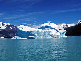
Grey Glacier is a glacier in the Southern Patagonian Ice Field, just west of the Cordillera del Paine. It flows southward into the lake of the same name. Before dividing in two at its front end, the glacier is 6 kilometers wide and over 30 meters high. In 1996, it occupied a total area of 270 km2 (100 sq mi) and a length of 28 km (17 mi). In November 2017 a large iceberg broke off the glacier.

<span class="mw-page-title-main">Aguilera (volcano)</span> Mountain in Chile

Aguilera is a stratovolcano in southern Chile. The volcano rises above the edge of the Southern Patagonian Ice Field. It is a remote volcano that was identified as such in 1985. The first ascent only occurred in 2014, making it the last unclimbed major Andean volcano.

<span class="mw-page-title-main">Patagonian Desert</span> Largest desert in Argentina

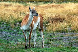
The Patagonian Desert, also known as the Patagonian Steppe, is the largest desert in Argentina and is the 8th largest desert in the world by area, occupying 673,000 square kilometers (260,000 mi2). It is located primarily in Argentina and is bounded by the Andes, to its west, and the Atlantic Ocean to its east, in the region of Patagonia, southern Argentina. To the north the desert grades into the Cuyo Region and the Monte. The central parts of the steppe are dominated by shrubby and herbaceous plant species albeit to the west, where precipitation is higher, bushes are replaced by grasses. Topographically the deserts consist of alternating tablelands and massifs dissected by river valleys and canyons. The more western parts of the steppe host lakes of glacial origin and grades into barren mountains or cold temperate forests along valleys.

<span class="mw-page-title-main">Tortel</span> Commune in Aisén, Chile

Tortel is a Chilean commune located at the outflow of the Baker River and Pascua River to the Pacific Ocean. It lies between the Northern and Southern Patagonian Ice Field in the Capitán Prat Province in the Aysén Region. The commune is administered by the municipality in Caleta Tortel, the principal settlement.

<span class="mw-page-title-main">Reclus (volcano)</span> Volcano located in the Patagonia Ice Field, Chile

Reclus, also written as Reclús, is a volcano located in the Southern Patagonian Ice Field, Chile. Part of the Austral Volcanic Zone of the Andes, its summit rises 1,000 metres (3,300 ft) above sea level and is capped by a crater about 1 kilometre (0.62 mi) wide. Close to the volcano lies the Amalia Glacier, which is actively eroding Reclus.

<span class="mw-page-title-main">Perito Moreno National Park</span> National park in Santa Cruz Province, Argentina

Perito Moreno National Park is a national park in Argentina. It is located in the western region of Santa Cruz Province on the border with Chile. It has an area of 126,830 hectares of mountains and valleys at a height of 900 metres above sea level.

Hiking in Chile is characterized by a wide range of environments and climates for hikers, which largely results from Chile's unusual, ribbon-like shape, which is 4,300 kilometres long and on average 175 kilometres wide. These range from the world's driest desert, the Atacama, in the north, through a Mediterranean climate in the center, to the glaciers, fjords and lakes of Patagonia in the south.

<span class="mw-page-title-main">Nahuel Huapi National Park</span> National park in Argentina

Nahuel Huapi National Park is the oldest national park in Argentina, established in 1922 as Parque Nacional de Sud and reconfiguered in 1934. It surrounds Nahuel Huapi Lake in the foothills of the Patagonian Andes. The largest of the national parks in the region, it has an area of 7,050 km2 (2,720 sq mi), or nearly 2 million acres. Its landscapes represent the north Patagonian Andean Zone consisting of three types, namely, the Altoandino, the Andino-Patagónico and the Patagonian steppe. It also represents small parts of the Valdivian Rainforest.

<span class="mw-page-title-main">Tierra del Fuego National Park</span> Argentine park

Tierra del Fuego National Park is a national park on the Argentine part of the island of Tierra del Fuego, within Tierra del Fuego Province in the ecoregion of Patagonic Forest and Altos Andes, a part of the subantarctic forest. Established on 15 October 1960 under the Law 15.554 and expanded in 1966, it was the first shoreline national park to be established in Argentina.

<span class="mw-page-title-main">Llanquihue glaciation</span> Last glacial period in southern Chile

The last glacial period and its associated glaciation is known in southern Chile as the Llanquihue glaciation. Its type area lies west of Llanquihue Lake where various drifts or end moraine systems belonging to the last glacial period have been identified. The glaciation is the last episode of existence of the Patagonian Ice Sheet. Around Nahuel Huapi Lake the equivalent glaciation is known as the Nahuel Huapi Drift.

The Paleolake Tehuelche is the name for several former lakes that existed in the area of Torres del Paine in southern Patagonia. These were proglacial lakes that existed next to the Patagonian Ice Sheet during the Late Pleistocene and Early Holocene. Some of the evidence of the lakes stem from lake terraces observable at present but these is some uncertainty on which terraces are associated to which lake or lake stage.

References

  1. 1 2 "CONAF, Por Un Chile Forestal Sustentable" (PDF) (in Spanish). CONAF. May 2013. p. 76. Retrieved 2 April 2017.
  2. 1 2 3 "Visitor Statistics" (PDF). National Forest Corporation (Chile). 2019. p. 3. Retrieved 28 November 2020.
  3. "Blown Away in Patagonia – Hiking Torres del Paine National Park". GORP.com. Archived from the original on 7 March 2012. Retrieved 2 January 2012.
  4. Abraham, Rudolf (2011). Torres del Paine: Trekking in Chile's Premier National Park. Milnthorpe: Cicerone Press. p. 17. ISBN   978-1-84965-356-5. Retrieved 4 August 2015.
  5. Dixie, Florence, Lady (1880). Across Patagonia.{{cite book}}: CS1 maint: multiple names: authors list (link) Available at the internet archive.
  6. 1 2 3 "History of the park". Official website. National Forest Service. Archived from the original on 25 March 2012. Retrieved 9 June 2011.
  7. "60th Anniversary of Torres del Paine National Park". www.google.com. Retrieved 16 May 2019.
  8. "Ice bold". The Sydney Morning Herald . 10 February 2007. Retrieved 13 September 2020.
  9. "History of Estancia Torres del Paine". Fantastico Sur Lodges. Archived from the original on 20 August 2010. Retrieved 25 May 2010.
  10. UNESCO Archived 2006-10-10 at the Wayback Machine - Park description at UNESCO World Biosphere Reserve
  11. 1 2 "Front page". El Mercurio. 2 January 2012.
  12. "Chile and Czech Republic work to restore Torres del Paine Park — MercoPress". En.mercopress.com. Retrieved 2 January 2012.
  13. S.A.P, El Mercurio. "La Segunda.com". LaSegunda.com (in Spanish). Retrieved 10 January 2019.
  14. Phillips, Tom (4 January 2012). "Chile's fire-ravaged Torres del Paine national park to partly reopen". The Guardian. ISSN   0261-3077 . Retrieved 5 November 2023.
  15. "Chile drops brush fire charges against Israeli". The Jerusalem Post | JPost.com. 9 February 2012. Retrieved 5 November 2023.
  16. Becerra, Alex; Diaz, Marcos; Zagal, Juan Cristobal. "Feasibility study of using a Small Satellite constellation to forecast, monitor and mitigate natural and man-made disasters in Chile and similar developing countries" (PDF). Archived from the original (PDF) on 16 October 2013. Retrieved 26 March 2013.
  17. "Cómo el fuego destruye esta reserva de la biósfera". El Mercurio. 2 January 2012.
  18. "Infografía: Áreas afectadas por el incendio en Torres del Paine". Emol.com. Archived from the original on 8 January 2012. Retrieved 2 January 2012.
  19. "Incendio en el Parque Torres del Paine fue provocado por un cigarro mal apagado". El Mostrador (in Spanish). 15 January 2019. Retrieved 14 March 2023.
  20. Francois, J.P. "Historia paleoambiental del ecotono bosque-estepa al interior del Parque Nacional Torres del Paine (Región de Magallanes, Chile) durante los últimos 14.800 años". Thesis.
  21. "Weather and Climate: Torres del Paine". Weather and Climate. 14 January 2020. Retrieved 14 January 2020.
  22. "Ecocamp Patagonia". Archived from the original on 2 January 2013. Retrieved 4 December 2012.
  23. Galloway, James N.; William C. Keene (20 March 1996). "Processes controlling the composition of precipitation at a remote southern hemispheric Location: Torres del Paine National Park, Chile". Journal of Geophysical Research. 101 (D3): 6883–6897. Bibcode:1996JGR...101.6883G. doi:10.1029/95jd03229 . Retrieved 4 December 2012.
  24. Fogwill, C.J.; P.W. Kubik (22 July 2005). "A Glacial Stage Spanning the Antarctic Cold Reversal in Torres del Paine (51°S), Chile, Based on Preliminary Cosmogenic Exposure Ages". Geografiska Annaler: Series A, Physical Geography. A. 87 (2): 403–408. doi:10.1111/j.0435-3676.2005.00266.x. S2CID   128400121.
  25. Marden, Christopher J. (1997). "Late-glacial fluctuations of South Patagonian Icefield, Torres del Paine National Park, southern Chile". Quaternary International. 38–39: 61–68. Bibcode:1997QuInt..38...61M. doi:10.1016/S1040-6182(96)00019-5.
  26. Rivera, Andrés; Gino Casassa (November 2004). "Ice Elevation, Areal, and Frontal Changes of Claciers from National Park Torres del Paine, Southern Patagonia Ice Field". Arctic, Antarctic, and Alpine Research . 36 (4): 379–389. doi:10.1657/1523-0430(2004)036[0379:IEAAFC]2.0.CO;2. S2CID   67848949. Archived from the original on 29 June 2012. Retrieved 4 December 2012.
  27. Uwe Altenberger; Roland Oberhansli; Benita Putlitz; et al. (July 2003). "Tectonic controls and Cenozoic magmatism at the Torres del Paine, southern Andes (Chile, 51°10'S)". Revista Geológica de Chile . 30 (1): 65–81. doi: 10.4067/S0716-02082003000100005 .
  28. Michel, Jürgen; Lukas Baumgartner; Benita Putlitz; Urs Schaltegger; Maria Ovtcharova (2008). "Incremental growth of the Patagonian Torres del Paine laccolith over 90 k.y." Geology. 36 (6): 459–462. Bibcode:2008Geo....36..459M. doi:10.1130/g24546a.1 . Retrieved 4 December 2012.
  29. Dinosaur graveyard discovered in Chile's Torres del Paine National Park. 4 June 2014. Archived from the original on 14 December 2021 via YouTube.
  30. "Video: Dinosaur 'graveyard' discovered in Chile - Telegraph". Telegraph.co.uk. 4 June 2014. Archived from the original on 5 June 2014.
  31. García, Juan-Luis; Hein, Andrew S.; Binnie, Steven A.; Gómez, Gabriel A.; González, Mauricio A.; Dunai, Tibor J. (2018). "The MIS 3 maximum of the Torres del Paine and Última Esperanza ice lobes in Patagonia and the pacing of southern mountain glaciation". Quaternary Science Reviews . 185: 9–26. Bibcode:2018QSRv..185....9G. doi:10.1016/j.quascirev.2018.01.013. hdl: 20.500.11820/d73c13fd-aeb3-4417-9158-4618d8263360 .
  32. 1 2 García, Juan-Luis; Hall, Brenda L.; Kaplan, Michael R.; Vega, Rodrigo M.; Strelin, Jorge A. (2014). "Glacial geomorphology of the Torres del Paine region (southern Patagonia): Implications for glaciation, deglaciation and paleolake history". Geomorphology . 204: 599–616. Bibcode:2014Geomo.204..599G. doi:10.1016/j.geomorph.2013.08.036. hdl: 10533/129777 .
  33. Solari, Marcelo A.; Le Roux, Jacobus P.; Hervé, Francisco; Airo, Alessandro; Calderón, Mauricio (2012). "Evolution of the Great Tehuelche Paleolake in the Torres del Paine National Park of Chilean Patagonia during the Last Glacial Maximum and Holocene". Andean Geology . 39 (1): 1–21. doi: 10.5027/andgeov39n1-a01 .
  34. "The First 100 IUGS Geological Heritage Sites" (PDF). IUGS International Commission on Geoheritage. IUGS. Retrieved 13 November 2022.
  35. Domínguez, Erwin (2004). "Catálogo preliminar de la familia Orchidaceae del Parque Nacional Torres del Paine, XII Región, Chile". Chloris Chilensis. 7 (1). Retrieved 1 November 2007.
  36. Domínguez, Erwin; Elvebakk, Arve; Clodomiro Marticorena; Aníbal Pauchard (December 2006). "Plantas introducidas en el Parque Nacional Torres del Paine, Chile". Gayana. Botánica . 63 (2): 131–141. doi: 10.4067/S0717-66432006000200001 .
  37. "Torres del Paine National Park (Official GANP Park Page)". national-parks.org. Retrieved 8 July 2022.
  38. Armesto, J.J.; I. Casassa; O.Dollenz (1992). "Age structure and dynamics of Patagonian beech forests in Torres del Paine National Park, Chile". Vegetatio. 98: 13–22. doi:10.1007/bf00031633. S2CID   24147789.
  39. "A Wild But Fragile Chile: Torres del Paine National Park". Sounds and Colours. 22 August 2011. Archived from the original on 2 October 2012. Retrieved 23 August 2011.
  40. Wilson, Paul (October 2009). "Puma predation on guanacos in Torres del Paine National Park, Chile". Mammalia. 48 (4). doi:10.1515/mamm.1984.48.4.515. S2CID   86558711.
  41. Jaksic, Fabián; Iriarte, J. Agustín; Jiménez, Jaime E. (June 2002). "Las rapaces del Parque Nacional Torres del Paine, Chile: biodiversidad y conservación". Rev. Chil. Hist. Nat. 75 (2): 449–461. doi: 10.4067/S0716-078X2002000200014 .
  42. "Torres del Paine Circuit Trek". backpackers-review.com. 8 January 2018. Retrieved 5 March 2019.
  43. "Fantastico Sur" . Retrieved 4 December 2012.
  44. "Vertice Patagonia" . Retrieved 4 December 2012.
  45. "Accommodation". TorresDelPaine.com. Retrieved 2 April 2017.
  46. "Attractions". sayhueque.com. Retrieved 17 February 2022.
  47. Farrell, Tracy A.; Jeffrey L. Marion (15 November 2010). "Trail Impacts and Trail Impact Management Related to Visitation at Torres del Paine National Park, Chile". Leisure. 26 (1–2): 31–59. doi:10.1080/14927713.2001.9649928. S2CID   145269658.
  48. "About Us". Parque Nacional Torres del Paine. Archived from the original on 30 October 2020. Retrieved 2 April 2017.
  49. "Interpatagonia" . Retrieved 4 December 2012.