
Krugersdorp is a mining city in the West Rand, Gauteng Province, South Africa founded in 1887 by Marthinus Pretorius. Following the discovery of gold on the Witwatersrand, a need arose for a major town in the west of the reef. The government bought part of the Paardekraal farm and named the new town after the Transvaal president, Paul Kruger. Krugersdorp no longer has a separate municipal government after it was integrated into Mogale City Local Municipality along with surrounding towns. It is now the seat of government for Mogale City.

Randfontein is a gold mining town in the West Rand, Gauteng, South Africa, 40 km (25 mi) west of Johannesburg. With the Witwatersrand gold rush in full swing, mining financier JB Robinson bought the farm Randfontein and, in 1889, floated the Randfontein Estates Gold Mining Company. The town was established in 1890 to serve the new mine and was administered by Krugersdorp until it became a municipality in 1929. Apart from having the largest stamp mill in the world, Randfontein, like many of the other outlying areas of Johannesburg, is essentially a rural collection of farms and small holdings in a particularly beautiful part of Gauteng.

The R24 is a major East-West provincial route in the Gauteng and North West provinces that links OR Tambo International Airport with Rustenburg via Johannesburg, Krugersdorp and Magaliesburg. The process of renaming the streets and freeway that form the route from Krugersdorp eastward to OR Tambo International after anti-apartheid stalwart Albertina Sisulu was completed in 2013.

The R28 is a provincial route in Gauteng, South Africa that connects Krugersdorp with Vereeniging via Randfontein. The R28 used to connect with Pretoria, but that section of the road is now part of the N14.
The R41 is a provincial route in Gauteng, South Africa, that connects Johannesburg with Randfontein via Roodepoort.

Tarlton International Raceway is a drag racing strip just outside Krugersdorp in South Africa on the R24 Route.

The N14 is a national route in South Africa which runs from Springbok in the Northern Cape to Pretoria in Gauteng. It passes through Upington, Kuruman, Vryburg, Krugersdorp and Centurion. The section between Pretoria and Krugersdorp is maintained by the Gauteng Provincial government and is also designated the P158, and is also a 4-lane dual carriageway with 2 lanes in each direction.

The South African Railways Class 34-400 of 1973 is a diesel-electric locomotive.
The R540 is a Regional Route in South Africa.
The R558 is a Regional Route in South Africa.
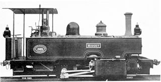
The Cape Government Railways Type C 0-4-0T Midget of 1902 was a South African steam locomotive from the pre-Union era in the Cape of Good Hope.
The R114 is a regional route in Gauteng, South Africa that runs from Muldersdrift to Centurion. The designation R114 is applied to sections of road that were previously part of the N14 that have been replaced by newly built freeway sections.

In South Africa some roads are designated as numbered routes to help with navigation. There is a nationwide numbering scheme consisting of national, provincial and regional routes, and within various urban areas there are schemes of metropolitan route numbering.

Krugersdorp Commando or Kommando was a light infantry regiment of the South African Army. It was active as a part of the South African Army Infantry Formation as well as the South African Territorial Reserve.
The M18 is a long metropolitan route in Greater Johannesburg, South Africa. It connects Krugersdorp with Bruma via Constantia Kloof, Florida, Auckland Park, Braamfontein and Observatory.
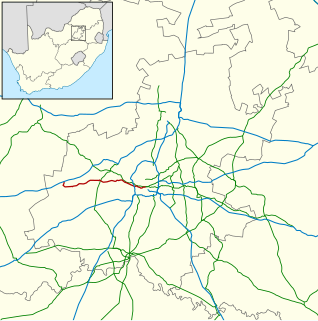
The M36 is a short metropolitan route in Greater Johannesburg, South Africa. The entire route is within the city of Krugersdorp in the Mogale City Local Municipality.
The M47 is a short metropolitan route in the City of Johannesburg, South Africa It connects the N14 at Cradlestone Mall with the M18 at Maraisburg in Roodepoort. It consists of only one street, named Hendrick Potgieter Road.
The M86 is a short metropolitan route in the Greater Johannesburg, South Africa. It connects Krugersdorp with Randpark Ridge via Roodepoort.
