Hudspeth County is a county located in the U.S. state of Texas. As of the 2010 census, the population was 3,476. Its county seat is Sierra Blanca, and the largest community is Fort Hancock. The county is named for Claude Benton Hudspeth, a state senator and United States Representative from El Paso. It is northeast from the Mexican border.

Culberson County is a county located in the U.S. state of Texas. As of the 2010 census, its population was 2,398. The county seat is Van Horn. Culberson County was founded in 1911 and organized the next year. It is named for David B. Culberson, a lawyer and Confederate soldier in the American Civil War.

The Southern Pacific was an American Class I railroad network that existed from 1865 to 1998 that operated in the Western United States. The system was operated by various companies under the names Southern Pacific Railroad, Southern Pacific Company and Southern Pacific Transportation Company.

The Atchison, Topeka and Santa Fe Railway, often referred to as the Santa Fe or AT&SF, was one of the larger railroads in the United States. Chartered in February 1859, the railroad reached the Kansas-Colorado border in 1873 and Pueblo, Colorado, in 1876. To create a demand for its services, the railroad set up real estate offices and sold farm land from the land grants that it was awarded by Congress. Despite the name, its main line never served Santa Fe, New Mexico, as the terrain was too difficult; the town ultimately was reached by a branch line from Lamy.

Downtown El Paso is the central business district of El Paso, Texas, United States.

The St. Louis Southwestern Railway, known by its nickname of "The Cotton Belt Route" or simply Cotton Belt, is a former US Class I railroad which operated between St. Louis, Missouri, and various points in the states of Arkansas, Tennessee, Louisiana, and Texas from 1891 to 1980. In 1980 the Cotton Belt began operating the Rock Island's Golden State Route which added the states of Kansas, Oklahoma, and New Mexico to the operation. Operation of the Cotton Belt was assumed by parent Southern Pacific in 1992.

The Texas and Pacific Railway Company was created by federal charter in 1871 with the purpose of building a southern transcontinental railroad between Marshall, Texas, and San Diego, California.
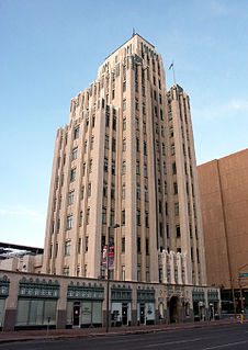
Trost & Trost Architects & Engineers, often known as Trost & Trost, was an architecture firm based in El Paso, Texas. The firm's chief designer was Henry Charles Trost, who was born in Toledo, Ohio, in 1860. Trost moved from Chicago to Tucson, Arizona in 1899 and to El Paso in 1903. He partnered with Robert Rust to form Trost & Rust. Rust died in 1905 and later that year Trost formed the firm of Trost & Trost with his twin brother Gustavus Adolphus Trost, also an architect, who had joined the firm as a structural engineer. Between 1903 and Henry Trost's death on September 19, 1933, the firm designed hundreds of buildings in the El Paso area and in other Southwestern cities, including Albuquerque, Phoenix, Tucson, and San Angelo.
Magic Landing was a theme park located in El Paso, Texas, operating from 1984 to 1988. Magic Landing was one of two amusement parks operating in El Paso during the 1980s, the other being Western Playland.

The National Museum of Transportation (NMOT) is a private, 42-acre transportation museum in Kirkwood, Missouri, outside St. Louis. Founded in 1944, it restores, preserves, and displays a wide variety of vehicles spanning 15 decades of American history: cars, boats, aircraft, and in particular, locomotives and railroad equipment from around the United States. The museum is also home to a research library of transportation-related memorabilia and documents.

El Paso Community College (EPCC) is a community college district headquartered in El Paso, Texas, United States. EPCC operates five campuses in the Greater El Paso area, as well as courses offered at nearby Fort Bliss.

Founded in 1959, The El Paso Museum of Art (EPMA) is located in downtown El Paso, Texas. First accredited in 1972, it is the only accredited art museum within a 250-mile radius and serves approximately 100,000 visitors per year. A new building was completed in 1998. In addition to its permanent collections and special exhibitions, the museum also offers art classes, film series, lectures, concerts, storytelling sessions and other educational programs to the West Texas, Southern New Mexico and Ciudad Juarez, Mexico community. EPMA's Algur H. Meadows Art Library houses a special collection of art and art history reference books.
The El Paso and Southwestern Railroad was a short-line American railway company which operated in Arizona, New Mexico, and Texas, with line extensions across the international border into Mexico. The railroad was known as the Arizona and South Eastern Railroad from 1888 to 1902.

The El Paso Public Library is the municipal public library system of El Paso, Texas. The library serves the needs the public in El Paso, Texas, Chaparral, New Mexico and Ciudad Juarez, Mexico. It consists of 13 branches and one Bookmobile service. Multiple outreach services are also available including a Homebound service.
The Museum & Railroad Historical Center of Greenwood is located in Greenwood, South Carolina. It offers a collection and interpretation of the history of the Lakelands region of South Carolina, especially Greenwood County.
The United Railroad Historical Society of New Jersey, Inc. is a non profit educational organization directed at supporting the preservation of New Jersey's historical railroad equipment and artifacts for the proposed New Jersey Transportation Heritage Center or in its absence, another railroad museum in New Jersey.
The following is a timeline of the history of the city of El Paso, Texas.
The history of the Southern Pacific stretches from 1865 to 1998. For the main page, see Southern Pacific Transportation Company; for the former holding company, see Southern Pacific Rail Corporation.