
U.S. Route 54 is an east–west United States Highway that runs northeast–southwest for 1,197 miles (1,926 km) from El Paso, Texas, to Griggsville, Illinois. The Union Pacific Railroad's Tucumcari Line runs parallel to US 54 from El Paso to Pratt, Kansas, which comprises about two-thirds of the route. Truckers refer to this road as "The Bee Line."

Northside High School, formerly Jefferson Davis High School, is a secondary school located at 1101 Quitman in the Near Northside neighborhood of Northside, Houston, Texas with a ZIP code of 77009. The school was previously named after Jefferson Davis, the only president of the Confederate States of America.

Phillis Wheatley High School is a secondary school located at 4801 Providence Street in Houston, Texas, United States with a ZIP code of 77020. Wheatley is a part of the Houston Independent School District. Wheatley, named after Phillis Wheatley, is located inside the 610 Loop in the Fifth Ward.

The El Paso Independent School District is the largest school district serving El Paso, Texas (USA). Originally organized in 1883, it is currently the largest district in the Texas Education Agency's Educational Service Center (ESC) Region 19, as well as the largest district within the city of El Paso and El Paso County. The EPISD also provides public education to the children of U.S. Army soldiers stationed at Fort Bliss. The district headquarters are located in El Paso.

Northeast El Paso is part of the city of El Paso, Texas and is located north of Central El Paso, and east of the Franklin Mountains. Its southern boundary is variously given as Fred Wilson Boulevard or Cassidy Road and Van Buren Avenue, and it extends northward to the New Mexico state line; some portions of this region lie outside the city limits, including parts of Franklin Mountains State Park and areas of Fort Bliss: the Logan Heights area of Fort Bliss around Chapin High School and Castner Range National Monument, an old firing range northwest of Hondo Pass Drive and Gateway South Boulevard. Development of Northeast El Paso, which had begun before the Second World War around the Logan Heights area, started in earnest during the 1950s, when many homes were demolished in the process of the construction of Interstate 10. It is one of the more ethnically diverse areas of town due to a high concentration of military families. Northeast El Paso has historically not developed at a rate comparable to East El Paso and Northwest El Paso, but in recent years, it has seen an increase in development. It is expected that the population in Northeast El Paso will grow more rapidly as a result of the troop increase for Fort Bliss in the coming years. Northeast El Paso has gained recognition throughout the city for schools like Parkland, Irvin, Andress and Chapin because of their outstanding athletic programs.

Franklin High School is a public high school located on the west side of El Paso, Texas, which is part of the El Paso Independent School District. It opened in 1993. Its name refers to the nearby Franklin Mountains. Although the student population of the school is usually between 2,000 and 3,000 annually, as of the 2023-24 school year, it exceeds 3,100. Since 2022, the principal has been Amanda Bowser.

Chapin High School is a public high school in El Paso, Texas. Chapin is located at the intersection of Dyer Street and Ellerthorpe Avenue. This land is reserved for the United States Government and is a part of the El Paso Independent School District. It is the only high school in the continental United States that is on government property but not owned by the government. The school enrolls over 1,800 students in grades 9 to 12. Nearly half of the students are military dependents from nearby Fort Bliss. The school also accepts students from throughout the city of El Paso as part of its pre-engineering magnet program.

Coronado High School in El Paso, Texas, United States is located on the west side of El Paso near the intersection of North Mesa Street and Resler Drive. It serves the southern part of west El Paso: east of Interstate 10, from the vicinity of Executive Center Boulevard north approximately three miles to around Coronado Arroyo, a normally dry stream bed running west down from the Franklin Mountains just north of Escondido Drive; and the portion of the Upper Valley which lies south of Country Club Road. Most of the Coronado attendance zone is zoned to Morehead Middle School for grades six to eight. The elementary schools in the Coronado feeder pattern include Dr. Green, L.B Johnson, Putnam, Carlos Rivera, Western Hills, and Zach White. The Upper Valley portion of the Coronado attendance area is zoned to Zach White Elementary and Lincoln Middle School, except for the Buena Vista neighborhood around Interstate 10 and West Paisano Drive, which is zoned to Johnson and Morehead. Dr. Green, L.B Johnson, Putnam, Carlos Rivera and Western Hills elementary schools all graduate into Morehead Middle School.

Park Foothills is a neighborhood in Northeast El Paso. It is located west of U.S. 54 to the Franklin Mountains, and from Mountain Ridge Drive and Atlas Avenue north to the boundary of Castner Range at Hondo Pass Avenue, mainly on a hill known as Wingate Point down which Hondo Pass and Hercules Avenue run, which forms part of the eastern foothills of the Franklin Mountains. It encompasses the officially recognized neighborhoods of Park Foothills and Sunrise Acres West, which includes the area east of Echo Street to the Patriot Freeway. Park Foothills is mainly residential and developed piecemeal as part of a slow ongoing process, consisting of apartment complexes of varying sizes and houses of varying styles built either individually or as part of small developments constructed beginning in the early 1950s, with a commercial area along Gateway South Boulevard at its eastern edge and smaller business districts around the intersections of Hercules Avenue and Leo Street, Magnetic Street and Hondo Pass Avenue, and Zion Drive with Alabama Street. Many of Park Foothills' streets are named for minerals or gemstones or have names with an astronomical theme. Sunrise Park at the center of Park Foothills is its only park of any size.
Near Northside is a historic neighborhood located in Northside, Houston, Texas. Near Northside is primarily occupied by people of Hispanic descent.
Burges High School in El Paso, Texas, United States, is a comprehensive high school in the El Paso Independent School District. It is located in the Cielo Vista neighborhood on the near east side of El Paso, north of the large shopping center Cielo Vista Mall and south of El Paso International Airport, and is the only El Paso Independent School District high school in East El Paso.

El Paso High School is the oldest operating high school in El Paso, Texas, and is part of the El Paso Independent School District. It serves the west-central section of the city, roughly south and west of the Franklin Mountains and north of Interstate 10 to the vicinity of Executive Center Boulevard. It is fed by Wiggs Middle School, into which the three elementary schools in its feeder pattern, Lamar, Mesita, and Vilas, graduate.
Angel's Triangle is a neighborhood located in Northeast El Paso in El Paso, Texas. It lies within a right triangle bordered by Dyer Street on the east, the Patriot Freeway on the west, and Hondo Pass Avenue on the north. Dominated by apartment complexes and older duplexes or single-family homes with a high poverty rate among its residents, and once notorious for crime, drug trafficking and prostitution, it was known as the Devil's Triangle before being officially renamed at a meeting of its residents in the 1990s. and is still sometimes referred to as such, or as the Triangle. The neighborhood's commercial portion is along its eastern and northern edges, on Dyer and on Hondo Pass, respectively; there is almost no business development along Gateway North Boulevard at the western edge of the Angel's Triangle.
Silva Magnet High School is a health-focused magnet high school within the El Paso Independent School District in El Paso, Texas.
Mountain View is a neighborhood in Northeast El Paso, in the city of El Paso, Texas. Its boundaries are commonly considered to be Dyer Street on the west, Railroad Drive on the east, Hondo Pass Avenue on the north, and on the south, Hercules Avenue and the intersection of Diana Drive and Railroad Drive; this includes the city-designated neighborhoods of Las Sierras and Restlawn as well as Mountain View North and South, which lie east of Diana Drive.
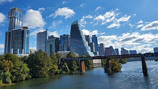
Downtown Austin is the central business district of Austin, Texas, United States. The area of the district is bound by Lamar Boulevard to the west, Martin Luther King Jr. Boulevard to the north, Interstate 35 to the east, and Lady Bird Lake to the south.

Bowie High School is one of the oldest operating high schools in El Paso, Texas and is part of the El Paso Independent School District. It is located in the Chamizal neighborhood in the South Central part of the city next to the border with Mexico, not far from the Bridge of the Americas linking El Paso with Ciudad Juarez, across San Marcial Street from Chamizal National Memorial.
Andress High School is a public high school located on the northeast side of El Paso, Texas. The school serves about 2,000 students in the El Paso Independent School District. It is located in the Sun Valley neighborhood at the intersection of Sun Valley Drive and Mackinaw Street. Andress High is currently the northernmost of EPISD's ten comprehensive high schools, serving the portion of Northeast El Paso between the Franklin Mountains and McCombs Street and north of Woodrow Bean Transmountain Road west of Girl Scout Way and Fairbanks Drive east of it, up to the New Mexico state line. Virtually all of the northern half of the Andress attendance zone, that is, north of Loma Real Avenue, is undeveloped land, most of it slated for future residential development. A new high school, as yet unnamed, which will serve what is now the portion of the Andress attendance zone north of the Patriot Freeway to the New Mexico state line, is in the planning stages, and was originally slated to be built using funding from a 2007 bond issue; however, in 2014 it was decided by the EPISD board of managers that development of the area did not yet justify a new high school and the funds set aside for its construction were reallocated. The money allocated went to Franklin High School.

Stephen F. Austin High School is a high school in El Paso, Texas. Austin opened in 1930. It is part of the El Paso Independent School District. The school's mascot is a golden panther named "Henry." Austin High School is located in the heart of historic Central El Paso and serves the Central community.

Irvin High School is an El Paso Independent School District (EPISD) high school in El Paso, Texas, United States. It opened in September 1959. It is named for Dr. O.C. Irvin, Dr. E.H. Irvin, and Mr. C. M. Irvin. All three of these men were well-known contributors to the El Paso public schools.


