The Puebloans, or Pueblo peoples, are Native Americans in the Southwestern United States who share common agricultural, material, and religious practices. Among the currently inhabited Pueblos, Taos, San Ildefonso, Acoma, Zuni, and Hopi are some of the best-known. Pueblo people speak languages from four different language families, and each Pueblo is further divided culturally by kinship systems and agricultural practices, although all cultivate varieties of maize.

San Elizario is a city in El Paso County, Texas, United States. Its population was 13,603 at the 2010 census. It is part of the El Paso metropolitan statistical area. It lies on the Rio Grande, which forms the border between the United States and Mexico. The city of Socorro adjoins it on the west and the town of Clint lies to the north.
Tiwa is a group of two, possibly three, related Tanoan languages spoken by the Tiwa Pueblo, and possibly Piro Pueblo, in the U.S. state of New Mexico.
The Pueblo Revolt of 1680, also known as Popé's Rebellion or Popay's Rebellion, was an uprising of most of the indigenous Pueblo people against the Spanish colonizers in the province of Santa Fe de Nuevo México, larger than present-day New Mexico. The Pueblo Revolt killed 400 Spaniards and drove the remaining 2,000 settlers out of the province. The Spaniards reconquered New Mexico twelve years later.
Piro people were a Native American tribe who lived in New Mexico during the 16th and 17th century. (The Piros They lived in a number of pueblos in the Rio Grande Valley around modern Socorro, New Mexico, USA. The now extinct Piro language may have been a Tanoan language. Numbering several thousand at the time of first contact with the Spanish, by the time of the Pueblo Revolt in 1680 the Piro had been decimated by European-introduced diseases and Apache attacks and most of the survivors resettled near El Paso, Texas.

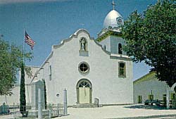
Ysleta del Sur Pueblo is a Native American Pueblo and federally recognized tribe in the Ysleta section of El Paso, Texas. Its members are Southern Tiwa people who had been displaced from Spanish New Mexico from 1680 to 1681 during the Pueblo Revolt against the Spaniards.
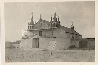
San Agustín de la Isleta Mission, founded in 1613, was a Spanish Mission in what is now Bernalillo County, New Mexico, United States. It was a religious outpost established by Spanish Catholic Franciscans, to spread Christianity among the local Native Americans.

Pueblo of Isleta is an unincorporated community and Tanoan pueblo in Bernalillo County, New Mexico, United States, originally established in the c. 14th century. The Southern Tiwa name of the pueblo is Shiewhibak (Shee-eh-whíb-bak) meaning "a knife laid on the ground to play whib", a traditional footrace. Its people are a federally recognized tribe.
Antonio de Otermín was the Spanish Governor of the northern New Spain province of Santa Fe de Nuevo México, today the U.S. states of New Mexico and Arizona, from 1678 to 1682. He was governor at the time of the Pueblo Revolt, during which the religious leader Popé led the Pueblo people in a military ouster of the Spanish colonists. Otermín had to cope with the revolt with help of the settlers and their descendants in New Mexico, fighting against the Pueblo in some military campaigns and establishing a refuge for the surviving settlers and loyal native Pueblo in the vicinity of the modern Ciudad Juárez, current Mexico.
The Suma were an Indigenous people of Aridoamerica. They had two branches, one living in the northern part of the Mexican state of Chihuahua and the other living near present-day El Paso, Texas. They were semi-nomadic hunter-gatherers who practiced little or no agriculture. The Suma merged with Apache groups and the mestizo population of northern Mexico, and are extinct as a distinct people.
Mission Valley is an area of El Paso, Texas, United States, which includes part of Eastside and all Lower Valley districts. It is the third largest area of the city, behind East El Paso and Central El Paso. Hawkins Road and Interstate 10 border the Mission Valley. This location is considered the oldest area of El Paso, dating back to the late 17th century when present-day Texas was under the rule of Nueva España.
The Tiwa or Tigua are a group of related Tanoan Puebloans in New Mexico. They traditionally speak a Tiwa language, and are divided into the two Northern Tiwa groups, in Taos and Picuris, and the Southern Tiwa in Isleta and Sandia, around what is now Albuquerque, and in Ysleta del Sur near El Paso, Texas.

The original Franciscan mission, Nuestra Señora de la Concepción del Socorro, was founded in 1682 by the Franciscan order, to serve displaced Spanish families, American Indians from New Mexico, who fled the central New Mexico region during the Pueblo Revolt. The present Socorro Mission was constructed around 1840 to replace an earlier 18th-century mission destroyed in 1829 by flooding of the Rio Grande. The mission, constructed of adobe surfaced with stucco, is particularly notable for its interior. The finely painted and decorated beams, or vigas, are from the 18th-century mission and were reused when the present church was constructed. The massing, details and use of decorative elements of the Socorro Mission show strong relationships to the building traditions of 17th-century Spanish New Mexico.
Senecú is a small Mexican village, now on the outskirts of Ciudad Juárez, Chihuahua. It is at an altitude of 1,123 m. and lies within the Chihuahuan Desert ecosystem.
Founded as El Paso del Norte by Spanish Franciscan friars at an important mountain pass, the area became a small agricultural producer though most settlement was south of the river where modern Mexico lies. The city was considered part of New Mexico under Spanish Conquerors and was tied economically to Santa Fe, New Mexico and the Chihuahuan mining districts of San Felipe El Real and San José del Parral.

The Ysleta Mission, located in the Ysleta del Sur Pueblo within the municipality of El Paso, Texas, is recognized as the oldest continuously operated parish in the State of Texas. The Ysleta community is also recognized as the oldest in Texas and claims to have the oldest continuously cultivated plot of land in the United States.
The Tompiro Indians were Pueblo Indians living in New Mexico. They lived in several adobe villages east of the Rio Grande Valley in the Salinas region of New Mexico. Their settlements were abandoned and they were absorbed into other Pueblo Nations in the 1670s.
The Manso Indians were an indigenous people who lived along the Rio Grande, from the 16th to the 17th century. Present-day Las Cruces, New Mexico developed in this area. The Manso were one of the indigenous groups to be resettled at the Guadalupe Mission in what is now Ciudad Juarez, Mexico. Some of their descendants remain in the area to this day.
Domingo Jironza Pétriz de Cruzate was a Spanish soldier who was Governor of New Mexico from 1683 to 1686, and again from 1689 to 1691. He came to office at a time a large part of the province of Santa Fe de Nuevo México was independent of Spanish rule due to the Pueblo Revolt. With limited resources, he was unable to reconquer the province.
Tortugas, New Mexico or Tortugas Pueblo is a community in Doña Ana County, New Mexico, just outside of Las Cruces, New Mexico. As of the 2020 census, the CDP's population was 579.