Macon County is a county located in the U.S. state of North Carolina. As of the 2010 census, the population was 33,922. Its county seat is Franklin.
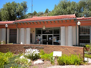
The City of Manitou Springs is a Home Rule Municipality located at the foot of Pikes Peak in western El Paso County, Colorado, United States. The town was founded for its natural mineral springs. The downtown area continues to be of interest to travelers, particularly in the summer, with many one-story small shops, restaurants, and pubs, as well as a creekside city park with a children's playground made from unusual materials. Among other services, shops sell clothing, candy, souvenirs, and outdoor recreation. The main road through the center of town was one of the direct paths to the base of Pikes Peak. Barr Trail, which winds its way up Pikes Peak, is accessible from town. The subdivision Crystal Hills was added to the municipality in the 1960s.

The Broadmoor Pikes Peak Cog Railway is an Abt rack system cog railway with 4 ft 8 1⁄2 instandard gauge track in Colorado, United States, climbing the well-known mountain Pikes Peak. The base station is in Manitou Springs, Colorado, near Colorado Springs.

The Manitou Cliff Dwellings are a group of relocated Ancestral Puebloan cliff dwellings and museums located just west of Colorado Springs, Colorado, on U.S. Highway 24 in Manitou Springs.
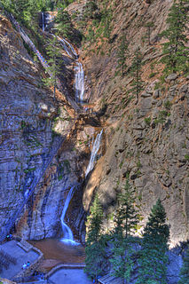
The Broadmoor Seven Falls is a series of seven cascading waterfalls of South Cheyenne Creek in South Cheyenne Cañon, Colorado Springs, Colorado. It has been a privately-owned tourist attraction since it was opened in the early 1880s.

Rainbow Springs State Park is a Florida state park located on U.S. 41, 3 miles (5 km) north of Dunnellon, Florida. It comprises 1,459.07 acres (5.9046 km2) upland and 12.83 acres (51,900 m2) submerged. The most significant natural feature is the first-magnitude headspring basin, which produces up to 600,000,000 US gallons (2,300,000 m3) of fresh water per day, forming the Rainbow River. The looking-glass waters of Rainbow Springs come from several vents, not one large bubbling spring. The river itself supports a wide variety of fish, wildlife, and plants, many within easy viewing by visitors. In total, the park contains 11 distinct natural communities, including sandhills, flatwoods, upland mixed forests, and hydric hammocks.

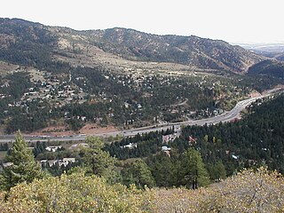
The Ute Pass is a mountain pass west of Colorado Springs that ranges from a peak elevation at Divide of 9,165 to 6,165 feet at its lowest point.

Cascade is an unincorporated community and U.S. Post Office in El Paso County, Colorado, United States. The ZIP Code of the Cascade Post Office is 80809.

State Highway 67 (SH 67) is a 71-mile-long (114 km) state highway encompassing five distinct segments in south-central Colorado. SH 67's southern terminus is at SH 96 in Wetmore, and the northern terminus is at U.S. Route 85 in Sedalia. It traverses the former route of the Florence and Cripple Creek Railroad through Phantom Canyon as a county road and carrying part of the Gold Belt Byway.

Before it was founded, the site of modern-day Colorado Springs, Colorado, was part of the American frontier. Old Colorado City, built in 1858 during the Pike's Peak Gold Rush was the Colorado Territory capital. The town of Colorado Springs, was founded by General William Jackson Palmer as a resort town. Old Colorado City was annexed into Colorado Springs. Railroads brought tourists and visitors to the area from other parts of the United States and abroad. The city was noted for junctions for seven railways: Denver and Rio Grande (1870), Denver and New Orleans Manitou Branch (1882), Colorado Midland (1886-1918), Colorado Springs and Interurban, Atchison, Topeka, and Santa Fe (1889), Rock Island (1889), and Colorado Springs and Cripple Creek Railways. It was also known for mining exchanges and brokers for the Cripple Creek Gold Rush.
Rainbow Falls is the name of several waterfalls:
Manitou Springs School District 14 is the main school district of Manitou Springs and its nearby communities at the western edge of El Paso County, Colorado.
U.S. Route 24 (US 24) is a part of the U.S. Highway System that travels from Minturn, Colorado, to Clarkston, Michigan. In the U.S. state of Colorado US 24 extends from Interstate 70 (I-70) and US 6 in Minturn east to the Kansas state line where it continues as US 24 concurrent with I-70.

Havasu Creek is a stream in the U.S. state of Arizona associated with the Havasupai people. It is a tributary to the Colorado River, which it enters in the Grand Canyon.

The Manitou Springs Incline, also known as the Manitou Incline or simply the Incline, is a popular hiking trail rising above Manitou Springs, Colorado, near Colorado Springs. The Incline ascends on the east slope of Rocky Mountain which is itself on the eastern flank of Pikes Peak. The trail is the remains of a former 3 ft narrow gauge funicular railway whose tracks washed out during a rock slide in 1990. The Incline is famous for its sweeping views and steep grade, with an average grade of 45% (24°) and as steep as 68% (34°) in places, making it a fitness challenge for locals of the Colorado Springs area. The incline gains 2,011 feet (613 m) of elevation in 0.88 miles (1.42 km) horizontal. Currently the Incline has approximately 2,744 steps from the bottom to the summit, although the top step is numbered "2768". The number of steps changes occasionally with trail maintenance and deterioration.

Manitou Springs Historic District in Manitou Springs, Colorado is roughly bounded by US 24, Ruxton Avenue, El Paso Boulevard and Iron Mountain Avenue. Listed in the National Register of Historic Places, it is one of the country's largest National Historic Districts.

Manitou Mineral Springs are natural mineral springs in Manitou Springs, Colorado and Cheyenne Spring House is on the National Register of Historic Places. The springs are located in one of the country's largest National Historic Districts.
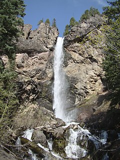
Treasure Falls is a waterfall in the San Juan Mountains, within Mineral County, Colorado. It is located in the San Juan National Forest, off U.S. Highway 160, about 15 miles (24 km) northeast of Pagosa Springs. The falls are named after a local legend about "a treasure of gold" buried in the mountain that the falls plunge from.
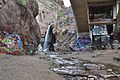
Iron Springs, a neighborhood in Manitou Springs, Colorado, was an area named for one of Manitou Mineral Springs. The Manitou area had been frequented by Native Americans who considered it a sacred and healing place before European Americans settled in Manitou.