
Mount Bachelor, formerly named Bachelor Butte, is a dormant stratovolcano atop a shield volcano in the Cascade Volcanic Arc and the Cascade Range of central Oregon. Named Mount Bachelor because it stands apart from the nearby Three Sisters, it lies in the eastern segment of the central portion of the High Cascades, the eastern segment of the Cascade Range. The volcano lies at the northern end of the 15-mile (24 km) long Mount Bachelor Volcanic Chain, which underwent four major eruptive episodes during the Pleistocene and the Holocene. The United States Geological Survey considers Mount Bachelor a moderate threat, but Bachelor poses little threat of becoming an active volcano in the near future. It remains unclear whether the volcano is extinct or just inactive.

Mount Jefferson is a stratovolcano in the Cascade Volcanic Arc, part of the Cascade Range in the U.S. state of Oregon. The second highest mountain in Oregon, it is situated within Linn County, Jefferson County, and Marion County and forms part of the Mount Jefferson Wilderness. Due to the ruggedness of its surroundings, the mountain is one of the hardest volcanoes to reach in the Cascades. It is also a popular tourist destination despite its remoteness, with recreational activities including hiking, backpacking, mountaineering, and photography. Vegetation at Mount Jefferson is dominated by Douglas fir, silver fir, mountain hemlock, ponderosa pine, lodgepole pine, and several cedar species. Carnivores, insectivores, bats, rodents, deer, birds, and various other species inhabit the area.

Three Fingered Jack is a summit of a shield volcano of the Cascade Range in the U.S. state of Oregon. Formed during the Pleistocene epoch, the mountain consists mainly of basaltic andesite lava and was heavily glaciated in the past. While other Oregon volcanoes that were heavily glaciated—such as Mount Washington and Mount Thielsen—display eroded volcanic necks, Three Fingered Jack's present summit is a comparatively narrow ridge of loose tephra supported by a dike only 10 feet (3.0 m) thick on a generally north–south axis. Glaciation exposed radiating dikes and plugs that support this summit. The volcano has long been inactive and is highly eroded.

Mount Washington is a deeply eroded volcano in the Cascade Range of Oregon. It lies within Deschutes and Linn counties and is surrounded by the Mount Washington Wilderness area.

Mount McLoughlin is a dormant steep-sided stratovolcano, or composite volcano, in the Cascade Range of southern Oregon and within the United States Sky Lakes Wilderness. It is one of the volcanic peaks in the Cascade Volcanic Arc, within the High Cascades sector. A prominent landmark for the Rogue River Valley, the mountain is north of Mount Shasta, and Crater Lake lies to the north-northeast. It was named around 1838 after John McLoughlin, a Chief Factor for the Hudson's Bay Company. Mount McLouglin's prominence has made it a landmark to Native American populations for thousands of years.
Medicine Lake Volcano is a large shield volcano in northeastern California about 30 mi (50 km) northeast of Mount Shasta. The volcano is located in a zone of east-west crustal extension east of the main axis of the Cascade Volcanic Arc and the Cascade Range. The 0.6 mi (1 km) thick shield is 22 mi (35 km) from east to west and 28 to 31 mi from north to south, and covers more than 770 sq mi (2,000 km2). The underlying rock has downwarped by 0.3 mi (0.5 km) under the center of the volcano. The volcano is primarily composed of basalt and basaltic andesite lava flows, and has a 4.3 by 7.5 mi caldera at the center.

Indian Heaven is a volcanic field in Skamania County in the state of Washington, in the United States. Midway between Mount St. Helens and Mount Adams, the field dates from the Pleistocene to the early Holocene epoch. It trends north to south and is dominated by six small shield volcanoes; these shields are topped by small spatter and cinder cones, and the field includes a number of subglacial volcanoes and tuyas. The northernmost peak in the field is Sawtooth Mountain and the southernmost is Red Mountain; its highest point is Lemei Rock at an elevation of 5,925 feet (1,806 m).

Mount Tehama is an eroded andesitic stratovolcano in the Cascade Volcanic Arc and the Cascade Range in Northern California. Part of the Lassen volcanic area, its tallest remnant, Brokeoff Mountain, is itself the second highest peak in Lassen Volcanic National Park and connects to the park's highest point, Lassen Peak. Located on the border of Tehama County and Shasta County, Brokeoff's peak is the highest point in the former. The hikers that summit this mountain each year are treated to "exceptional" views of Lassen Peak, the Central Valley of California, and many of the park's other features. On clear days, Mount Shasta can also be seen in the distance.

Goat Rocks is an extinct stratovolcano in the Cascade Range, located between Mount Rainier and Mount Adams in southern Washington, in the United States. Part of the Cascade Volcanoes, it was formed by the subduction of the Juan de Fuca Plate under the western edge of the North American Plate. The volcano was active from 3.2 million years ago until eruptions ceased between 1 and 0.5 million years ago. Throughout its complex eruptive history, volcanism shifted from silicic explosive eruptions to voluminous, mafic activity.

The Chilcotin Group, also called the Chilcotin Plateau Basalts, is a large area of basaltic lava that forms a volcanic plateau running parallel with the Garibaldi Volcanic Belt in south-central British Columbia, Canada.

Broken Top is a glacially eroded complex stratovolcano. It lies in the Cascade Volcanic Arc, part of the extensive Cascade Range in the U.S. state of Oregon. Located southeast of the Three Sisters peaks, the volcano, residing within the Three Sisters Wilderness, is 20 miles (32 km) west of Bend, Oregon in Deschutes County. Eruptive activity stopped roughly 100,000 years ago, and currently, erosion by glaciers has reduced the volcano's cone to where its contents are exposed. There are two named glaciers on the peak, Bend and Crook Glacier.

Black Butte is an extinct stratovolcano in the U.S. state of Oregon. Located in Jefferson County, it is part of Deschutes National Forest. Black Butte forms part of the Cascade volcanic arc. The butte lies just south of the Metolius Springs, which merge to form the headwaters of the Metolius River. The Metolius River's basin sustains a wide array of plant life, large and small mammals, and more than 80 bird species.

The Spectrum Range, formerly called the Spectrum Mountains and the Rainbow Mountains, is a subrange of the Tahltan Highland in the Stikine Country of northwestern British Columbia, 20 km west of the Stewart-Cassiar Highway, south of Mount Edziza and north of the Arctic Lake Plateau. The Spectrum Range falls within Mount Edziza Provincial Park. The range is lightly glaciated, as compared to the other ranges to the west. It is accessible only by foot or via helicopter; there are no roads to the range.

Diamond Peak is a volcano in Klamath and Lane counties of central Oregon in the United States. It is a shield volcano, though it might also be considered a modest stratocone. Diamond Peak forms part of the Cascade Volcanic Arc, a segment of the Cascade Range in western North America extending from southern British Columbia through Oregon to Northern California. Reaching an elevation of 8,748 feet (2,666 m), the mountain is located near Willamette Pass in the Diamond Peak Wilderness within the Deschutes and Willamette national forests. Surrounded by coniferous forest and visible in the skyline from foothills near Eugene, Diamond Peak offers a few climbing routes and can be scrambled. Diamond Peak is one of Oregon's Matterhorns.
Big Cave is a small shield volcano located in northern California in the Cascade Volcanic Arc of the Pacific Northwest. With an elevation listed at either 4,130 feet (1,260 m) or 4,131 feet (1,259 m), it is the product of subduction of several tectonic plates under the North American Plate, which continues at a rate of 4 centimetres (1.6 in) each year.
Hoodoo Butte is a cinder cone butte in the Cascade Range of northern Oregon, located near Santiam Pass. Immediately to the east lies Hayrick Butte, a prime example of a tuya; the two mountains' names were likely mistaken for each other, but stuck with them over time. The area has been subjected to a number of historic fires. Hoodoo is sometimes considered a subfeature of the Mount Washington shield volcano, and it forms part of the Sisters Reach, which extends from South Cinder Peak to Crane Prairie Reservoir, running for 56 miles (90 km). This region has a high vent density, with many mafic volcanoes of Pleistocene to Holocene age, such as Hoodoo. While Hoodoo has an intact summit crater that was blocked from erosion by glaciers, it has an irregular topography, giving it an open appearance.
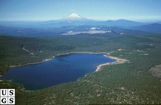
The Mountain Lakes Wilderness is a wilderness area located in the Fremont–Winema National Forest in the southern Cascade Range of Oregon in the United States. It surrounds a cluster of four overlapping shield volcanoes, the highest of which is 8,208-foot (2,502 m) Aspen Butte. Over 20 small lakes lie along the bottoms of several large cirques carved by Ice Age glaciers near the summits of the volcanoes.

The geology of the Pacific Northwest includes the composition, structure, physical properties and the processes that shape the Pacific Northwest region of North America. The region is part of the Ring of Fire: the subduction of the Pacific and Farallon Plates under the North American Plate is responsible for many of the area's scenic features as well as some of its hazards, such as volcanoes, earthquakes, and landslides.
Round Mountain is an eroded volcanic outcrop in the Garibaldi Volcanic Belt in British Columbia, Canada, located 8 km southwest of Eanastick Meadows, 9 km (6 mi) east of Brackendale and 10 km (6 mi) south of Mount Garibaldi. It is the highpoint of Paul Ridge and is located in the southwest corner of Garibaldi Provincial Park. Round Mountain formed as a result of subduction of the Juan de Fuca Plate beneath the North American Plate, known as the Cascadia subduction zone. Round Mountain last erupted during the Pleistocene.
Trout Creek Hill is a small Pleistocene basaltic shield volcano in Washington, United States. Located in Skamania County, Trout Creek Hill rises to an elevation of 2,946 feet (898 m). It is part of the Cascade Volcanic Arc, located in the Marble Mountain-Trout Creek Hill volcanic field.

