
The Devon Wildlife Trust is a member of The Wildlife Trusts partnership covering the county of Devon, England. It is a registered charity, established in 1962 as the Devon Naturalists Trust, and its aim is to safeguard the future of the county's urban, rural and marine wildlife and its environment.

Durham Wildlife Trust is a registered charity that was established in 1971, originally as the Durham County Conservation Trust, becoming Durham Wildlife Trust in 1988. The Trust operates across the area of the old County Durham, which includes Darlington, Gateshead, South Tyneside and Sunderland.
The Avon Wildlife Trust aims to protect and promote wildlife in the area of the former county of Avon — now Bath and North East Somerset, Bristol, North Somerset and South Gloucestershire, in England. It has its headquarters in Bristol and runs wildlife centres at Folly Farm, Somerset and Grow Wilder, Frenchay, North Bristol.

The Stiperstones is a distinctive hill in Shropshire, England. The quartzite rock of the ridge formed some 480 million years ago. During the last Ice Age Stiperstones lay on the eastern margin of the Welsh ice sheet. The hill itself was not glaciated though glaciers occupied surrounding valleys and it was subject to intense freezing and thawing which shattered the quartzite into a mass of jumbled scree surrounding several residual rocky tors. At 536 metres (1,759 ft) above sea level it is the second-highest hill in the county, surpassed only by Brown Clee Hill. Stiperstones' 8-kilometre (5 mi) summit ridge is crowned by several jagged outcrops of rock, which may be seen silhouetted against the sky.

Henfield is a large village and civil parish in the Horsham District of West Sussex, England. It lies 41 miles (66 km) south of London, 12 miles (19 km) northwest of Brighton, and 30 miles (48 km) east northeast of the county town of Chichester at the road junction of the A281 and A2037. The parish has a land area of 4,285 acres (1,734.1 ha). In the 2001 census 5,012 people lived in 2,153 households, of whom 2,361 were economically active. Other nearby towns include Burgess Hill to the east and Shoreham-by-Sea to the south. The population at the 2011 Census was 5,349.

The Cotswold Water Park is the United Kingdom's largest marl lake system, straddling the Wiltshire–Gloucestershire border, north-west of Cricklade and south of Cirencester. There are 180 lakes, spread over 42 square miles (110 km2).

The Sussex Wildlife Trust (SWT) is a conservation charity which aims to protect natural life in Sussex. It was founded in 1961 and is one of 46 wildlife trusts across the UK and the Isle of Man and Alderney. As of 2019, it has 33,000 members and manages 2,000 hectares of land for nature. It is a registered charity and in the year to 31 March 2019 it had an income of £5.7 million and expenditure of £4 million, resulting in net income of £1.7 million.

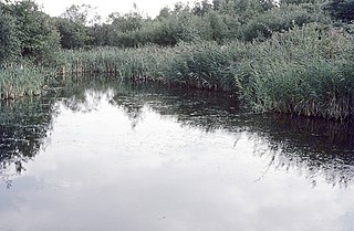
Coombe Hill Canal lies in the Vale of Gloucester, south west England, north of Leigh and runs west 2.75 miles (4.43 km) from Coombe Hill Basin to the River Severn near Wainlode Hill. It opened in 1796 and closed 80 years later in 1876, after the only lock was damaged by flooding. The Gloucestershire Wildlife Trust purchased the Coombe Hill Canal nature reserve in 1985 and the area is managed by the trust. Adjacent to the Coombe Hill Canal is a large area of wet meadowland situated midway between Gloucester and Tewkesbury to the west of the A38, which was purchased by the trust in 1999. There is a north and a south meadow. This land and the Canal itself often flood in winter, which attracts hundreds of wildfowl.

Camley Street Natural Park is an urban nature reserve in St Pancras in central London and within the London Borough of Camden. It is a local nature reserve.
London Wildlife Trust (LWT), founded in 1981, is a local nature conservation charity for Greater London. It is one of 46 members of the Royal Society of Wildlife Trusts, each of which is a local nature conservation charity for its area. The Trust aims to protect London's wildlife and wild spaces, and it manages 36 nature reserves in Greater London. The Trust provides education services for schools. Local groups work on reserves and organise walks.

Lower Woods is a 280.1-hectare (692-acre) biological and geological Site of Special Scientific Interest near the village of Wickwar, South Gloucestershire, notified in 1966 and renotified in 1985. The site area has increased at last revision in 1974 to a 284.1-hectare (702-acre) site. The site is a nature reserve managed by the Gloucestershire Wildlife Trust.

Ebernoe is a hamlet and civil parish in the District of Chichester in West Sussex, England, and 4 miles (6 km) north of Petworth near the A283 road.

Joe's Pond is a 4-hectare (9.9-acre) Site of Special Scientific Interest that lies to the east of, and adjacent to, the Rainton Meadows nature reserve in Tyne and Wear, England.

Baggeridge Country Park is located within the South Staffordshire district of Staffordshire, England. Its entrance is on the A463 just west of Gospel End, a small Staffordshire village just beyond the borders of the Wolverhampton, Gornal and the surrounding Metropolitan Borough of Dudley.

Gunnersbury Triangle is a 2.57-hectare (6.4-acre) local nature reserve in Chiswick, in the London boroughs of Ealing and Hounslow, immediately to the east of Gunnersbury. It was created in 1983 when, for the first time in Britain, a public inquiry ruled that a planned development of the land could not go ahead because of its value for nature. It opened as a nature reserve in 1985.

Dymock Woods is a 53-hectare (130-acre) biological Site of Special Scientific Interest in Gloucestershire, notified in 1990. The site is listed in the 'Forest of Dean Local Plan Review' as a Key Wildlife Site (KWS).

Vell Mill Daffodil Meadow is a 2.1-hectare (5.2-acre) nature reserve in Gloucestershire.

Adelaide Local Nature Reserve is in North West London, in the area of Chalk Farm, Primrose Hill, Belsize Park and Swiss Cottage. It is managed by a local volunteer group, the Adelaide Nature Reserve Association, which works with the council to improve the site for wildlife and local community use and enjoyment. The site is a Local Nature Reserve and Site of Borough Importance for Nature Conservation, Grade 1.
Fingringhoe Wick is a 48.6-hectare (120-acre) nature reserve in Fingringhoe in Essex. It is managed by the Essex Wildlife Trust, which runs a visitor centre on the site. It is part of the Colne Estuary Site of Special Scientific Interest, Ramsar site and Nature Conservation Review site.

