Krakatoa, also transcribed Krakatau, is a caldera in the Sunda Strait between the islands of Java and Sumatra in the Indonesian province of Lampung. The caldera is part of a volcanic island group comprising four islands. Two, Lang and Verlaten, are remnants of a previous volcanic edifice destroyed in eruptions long before the famous 1883 eruption; another, Rakata, is the remnant of a much larger island destroyed in the 1883 eruption.

A volcano is a rupture in the crust of a planetary-mass object, such as Earth, that allows hot lava, volcanic ash, and gases to escape from a magma chamber below the surface.

The Ring of Fire is a region around much of the rim of the Pacific Ocean where many volcanic eruptions and earthquakes occur. The Ring of Fire is a horseshoe-shaped belt about 40,000 km (25,000 mi) long and up to about 500 km (310 mi) wide.

The Bromo, or Mount Bromo is an active somma volcano and part of the Tengger mountains, in East Java, Indonesia. At 2,329 meters (7,641 ft) it is not the highest peak of the massif, but the most famous. The area is one of the most visited tourist destinations in East Java, and the volcano is included in the Bromo Tengger Semeru National Park. The name Bromo comes from the Javanese pronunciation of Brahma, the Hindu god of creation. Mount Bromo is located in the middle of a plain called "Sea of Sand", a nature reserve that has been protected since 1919.

Lampung, officially the Province of Lampung, is a province of Indonesia. It is located on the southern tip of the island of Sumatra. It has a short border with the province of Bengkulu to the northwest, and a longer border with the province of South Sumatra to the north. It is the original home of the Lampung people, who speak their own language, and possess their own written script. Its capital is Bandar Lampung.

Mount Merapi, Gunung Merapi, is an active stratovolcano located on the border between the province of Central Java and the Special Region of Yogyakarta, Indonesia. It is the most active volcano in Indonesia and has erupted regularly since 1548. It is located approximately 28 km (17 mi) north of Yogyakarta city which has a population of 2.4 million, and thousands of people live on the flanks of the volcano, with villages as high as 1,700 m (5,577 ft) above sea level.

Mount Agung is an active volcano in Bali, Indonesia, southeast of Mount Batur volcano, also in Bali. It is the highest point on Bali, and dominates the surrounding area, influencing the climate, especially rainfall patterns. From a distance, the mountain appears to be perfectly conical. From the peak of the mountain, it is possible to see the peak of Mount Rinjani on the nearby island of Lombok, to the east, although both mountains are frequently covered in clouds. Agung is a stratovolcano, with a large and deep crater. Its most recent eruptions occurred from 2017–2019.
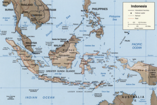
The Sunda Arc is a volcanic arc that produced the volcanoes that form the topographic spine of the islands of Sumatra, Nusa Tenggara, and Java, the Sunda Strait and the Lesser Sunda Islands. The Sunda Arc begins at Sumatra and ends at Flores, and is adjacent to the Banda Arc. The Sunda Arc is formed via the subduction of the Indo-Australian Plate beneath the Sunda and Burma plates at a velocity of 63–70 mm/year.

Mount Rinjani is an active volcano in Indonesia on the island of Lombok. Administratively the mountain is in the Regency of North Lombok, West Nusa Tenggara. It rises to 3,726 metres (12,224 ft), making it the second highest volcano in Indonesia. It is also the highest point in the Indonesian province of West Nusa Tenggara.

Bandar Lampung is the capital and largest city of the Indonesian province of Lampung. Located on the southern tip of Sumatra, Bandar Lampung was originally called Tanjungkarang–Telukbetung, since it was a unification of two major settlements in Lampung, before being renamed in 1983.

Anak Krakatoa is a volcanic island in Indonesia. On 29 December 1927, Anak Krakatoa first emerged from the caldera formed in 1883 by the explosive volcanic eruption that destroyed the island of Krakatoa. There has been sporadic eruptive activity at the site since the late 20th century, culminating with a large underwater collapse of the volcano that caused a deadly Tsunami in December 2018. There has been subsequent activity since. Due to its young age, the island is one of several in the area that are of interest to, and the subject of extensive study by, volcanologists.

The Sidoarjo mud flow is the result of an erupting mud volcano in the subdistrict of Porong, Sidoarjo in East Java, Indonesia that has been in eruption since May 2006. It is the biggest mud volcano in the world; responsibility for the disaster was assigned to the blowout of a natural gas well drilled by PT Lapindo Brantas, although company officials contend it was caused by a very distant earthquake that occurred in a different province.

Mount Sinabung is a Pleistocene-to-Holocene stratovolcano of andesite and dacite in the Karo plateau of Karo Regency, North Sumatra, Indonesia, 40 kilometres (25 mi) from the Lake Toba supervolcano. Many old lava flows are on its flanks and the last known eruption, before recent times, occurred 1200 years before present, between 740 - 880 CE. Solfataric activities were last observed at the summit in 1912; recent documented events include an eruption in the early hours of 29 August 2010 and eruptions in September and November 2013, January, February and October 2014. The volcano has recently claimed the life of at least 23 people in a number of events since 2014. Between 2013 and 2014, the alert for a major event was increased with no significant activity. On 2 June 2015, the alert was again increased, and on 26 June 2015, at least 10,000 people were evacuated, fearing a major eruption. The long eruption of Mount Sinabung is similar to that of Mount Unzen in Japan, which erupted for five years after lying dormant for 400 years. A major eruption began on 10 August 2020.

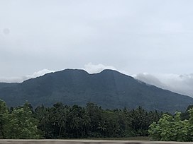
Mount Gede or Gunung Gede is a stratovolcano in West Java, Indonesia. The volcano contains two peaks with Mount Gede as one peak and Mount Pangrango for the other one. Three major cities, Cianjur, Sukabumi and Bogor, are located in the volcano complex at the east, south and northwest, respectively, along with suburban growth. Seven craters are located in the complex: Baru, Gumuruh (2,927 m), Lanang (2,800 m), Kawah Leutik, Ratu (2,800 m), Sela (2,709 m) and Wadon (2,600 m). Historical volcanic activity has been recorded since the 16th century. With the amalgamation and growth of Greater Jakarta with those 3 cities, dense suburban growth has engulfed the fringes of the volcano, home to roughly 4 million people. Though not listed as one of the Decade Volcanoes or thought to produce large eruptions, the huge populations nearby give a potential for severe destruction if indeed a large eruption did occur.

Several types of volcanic eruptions—during which lava, tephra, and assorted gases are expelled from a volcanic vent or fissure—have been distinguished by volcanologists. These are often named after famous volcanoes where that type of behavior has been observed. Some volcanoes may exhibit only one characteristic type of eruption during a period of activity, while others may display an entire sequence of types all in one eruptive series.
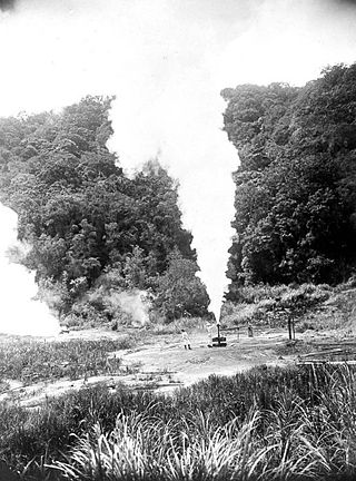
Geothermal power in Indonesia is an increasingly significant source of renewable energy. As a result of its volcanic geology, it is often reported that Indonesia has 40% of the world's potential geothermal resources, estimated at 28,000 megawatts (MW).
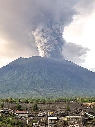
Mount Agung, a volcano on the island of Bali in Indonesia, erupted five times in late November 2017, causing thousands to evacuate, disrupting air travel and causing environmental damage. As of 27 November 2017, the alert level was at its highest and evacuation orders were in place.

Kertapati Station (KPT) is a railway station located in Kemas Rindo, Kertapati, Palembang, South Sumatra, Indonesia. It is operated the Regional Division III Palembang of Kereta Api Indonesia, and become the main station of the city. The station is close to the Musi River and Ogan River.
The Muria rock gecko is a species of diurnal, rock-dwelling, insectivorous gecko endemic to Indonesia. It is distributed throughout Java. It was first identified by Riyanto et al (2019) on the southern slopes of Gunung Muria, a dormant volcano in central Java. To date, this is the only known location for the genus Cnemaspis on the island of Java. This discovery is geographically significant as the closest other species of Cnemaspis was found in Lampung, roughly 580 km away. The holotype was caught at night and subsequent species were only found on large rocky microhabitats alongside rivers and coffee plantations. As it is an insectivore, it is believed to eat pests found on coffee plants; there are concerns about the use of insecticides jeopardizing the geckos as natural pest control agents.