Myanglung is a municipality and the district headquarters of Terhathum District of Koshi Province in eastern Nepal. The "myang" means cat and "lung" means stone in Limbu language.The story is that the cat (myang) in ancient time, pawed the stone (lung) in anger. The municipality is situated at an elevation of about 1500 metres above sea level. Myanglung was converted into a municipality from a village development committee on 18 May 2014, merging the existing village development committees of Myanglung, Piple, Jirikhimti, Ambung, Sabla and Tamphula. According to the census of 2011 the total population of Myanglung is 19,659 including five VDCs.
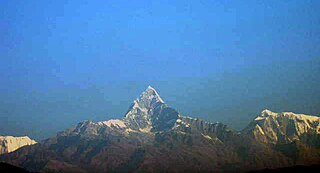
Machhapuchchhre is a Gaunpalika and former village development committee in Kaski District in the Gandaki Province of northern-central Nepal. At the time of the 1991 Nepal census it had a population of 1,881 persons living in 378 individual households.
Gauriganga Municipality is a municipality in Kailali District in the Sudurpashchim Province. At the time of the 2011 Nepal census it had a population of 55,314 living in 5,293 individual households. It is Surrounded by Ghodaghodi Municipality in the west, Godawari Municipality in the east, Mohanyal and Chure Rural Municipality in the north and Dhangadhi Sub Metropolitan City and Kailari Rural Municipality in the south.
Chainpur is a municipality in Sankhuwasabha District in the Koshi Province of north-eastern Nepal. It was formed by merging five villages i.e. Chainpur, Siddhakali, Siddhapokhari, Baneshwar and Kharang. The municipality was implemented on 18 May 2014. At the time of the 1991 Nepal census it had a population of 4933 people in 948 households.
Belauri, The former village development committee was converted into municipality, merging with existing Rampur Bilaspur, Laxmipur and Sreepur village development committee on 18 May 2014. At the time of the 1991 Nepal census it had a population of 14,280 people living in 1877 individual households.
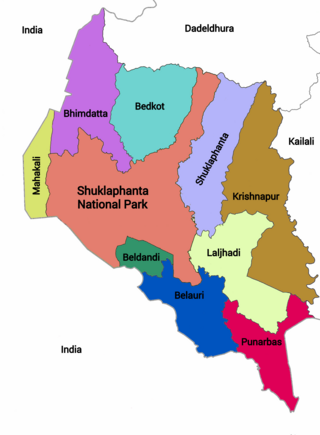
Punarwas is a Municipality in Kanchanpur District in Sudurpashchim Province of south-western Nepal. The new Municipality was established on 18 May 2014 by merging the existing 3 Village Development Committees i.e. Parasan, Tribhuwanbasti and Kalika. At the time of the 2011 Nepal census, it had a population of 43,996 people living in Punarwas.
Manahari is a Rural Municipality in Makwanpur District in the Bagmati Province of Nepal. At the time of the 1991 Nepal census it had a population of 10,013 people living in 1789 individual households.

Tarakeshwar is a municipality in Kathmandu District in Bagmati Province of Nepal that was established on 2 December 2014 by merging the former Village development committees Dharmasthali, Futung, Goldhunga, Jitpurphedi, Kavresthali, Manmaiju and Sangla. The office of the municipality is that of the former Dharmasthali village development committee.
Bansgadhi is a municipality in the Bardiya District in southwestern Nepal.

Gadhawa Rural Municipality is located in Deukhuri valley of Dang district of Lumbini Province, Nepal. This rural municipality was declared on Falgun 12, 2073 Vikram Samvat. It lies from 195 meter to 885 meter above sea level. The former Gadhawa VDC office was the administrative center of Gadhawa Rural Municipality for 4 years of its inception and then the office of the executive was moved to a new building. According to the preliminary report of population census 2078, Gadhawa Rural Municipality has 46275 population where male and female comprises 22650 (48.95%) and 23625 (51.05%) population respectively. During local level restructuring, this rural municipality was formed by annexing former four VDCs named Gobardiya, Gangapraspur, Gadhawa and Koilabas. This rural municipality has a 358.57 square km area and is divided into 8 wards. It is surrounded by Arghakhanchi and Kapilvastu districts from the east, Rajapur Rural Municipality from the west, Lamahi Municipality and Rapti Rural Municipality in the north, and India in the south direction.
Rajpur Rural Municipality is a municipal unit in Dang District, Lumbini Province in western Nepal. It was formed by a combination of the erstwhile Bela and Rajpur Village Development Committees. The center of the Rural Municipality is located at Gangdi.
Chaukune is a rural municipality located in Surkhet District of Karnali Province of Nepal.
Ghiring Rural Municipality (Ghiring Gaupalika) (Nepali: घिरिङ्ग गाउँपालिका) is a Gaunpalika in Tanahaun District in Gandaki Province of Nepal. On 12 March 2017, the government of Nepal implemented a new local administrative structure, in which VDCs have been replaced with municipal and Village Councils. Ghiring is one of these 753 local units.
Myagde Rural Municipality (Myagde Gaupalika) (Nepali: म्याग्दे गाउँपालिका) is a Gaunpalika in Tanahaun District in Gandaki Province of Nepal. On 12 March 2017, the government of Nepal implemented a new local administrative structure, in which VDCs have been replaced with municipal and Village Councils. Myagde is one of these 753 local units.
Gharapjhong Rural Municipality (Gharapjhong Gaupalika) (Nepali: घरपझोङ गाउँपालिका) is a Gaunpalika, or rural municipality, in Mustang district in Gandaki Province of Nepal. On 12 March 2017, the government of Nepal implemented a new local administrative structure, in which Village Development Committees were replaced with municipal and Village Councils. Gharapjhong is one of these 753 local units.

Rapti Rural Municipality is a gaunpalika in Dang District in Lumbini Province of Nepal. On 12 March 2017, the government of Nepal implemented a new local administrative structure, with the implementation of the new local administrative structure, VDCs have been replaced with municipal and Village Councils. Rapti is one of these 753 local units.
Madhuwan is a municipality located in Bardiya District of Lumbini Province of Nepal. It is one out of six municipality of Bardiya District. The municipality is surrounded by Gulariya and Barbardiya in the east, India borders from the west, Thakurbaba and Geruwa Rural Municipality in the north. Bardiya National Park touches the border of the municipality by north.

Indrasarowar is a rural municipality located within the Makwanpur District of the Bagmati Province, Nepal. The municipality spans 97.33 square kilometres (37.58 sq mi) of area, with a total population of 17,585 according to a 2011 Nepal census.
Likhutamakoshi is a Rural municipality located within the Ramechhap District of the Bagmati Province of Nepal. The municipality spans 124.51 square kilometres (48.07 sq mi) of area, with a total population of 23,109 according to the 2011 Nepal census.
Sarumarani is a Rural municipality located within the Pyuthan District of the Lumbini Province of Nepal. The rural municipality spans 157.97 square kilometres (60.99 sq mi) of area, with a total population of 18,627 according to a 2011 Nepal census.

