Jackson County is a county located in the U.S. state of Michigan. Its population was 160,366 as of the 2020 Census. The county seat is Jackson. The county was set off in 1829 and organized in 1832. It is named for U.S. President Andrew Jackson and considered to be one of Michigan's "Cabinet counties", named for members of Jackson's Cabinet.

Buena Park is a city in northern Orange County, California, United States. As of the 2020 census its population was 84,034. It is the location of several tourist attractions, including Knott's Berry Farm. It is about 12 miles (20 km) northwest of downtown Santa Ana, the county seat, and is within the Los Angeles metropolitan area.

Fullerton is a city located in northern Orange County, California, United States. As of the 2020 census, the city had a total population of 143,617.

John Day Fossil Beds National Monument is a U.S. national monument in Wheeler and Grant counties in east-central Oregon. Located within the John Day River basin and managed by the National Park Service, the park is known for its well-preserved layers of fossil plants and mammals that lived in the region between the late Eocene, about 45 million years ago, and the late Miocene, about 5 million years ago. The monument consists of three geographically separate units: Sheep Rock, Painted Hills, and Clarno.

Coyote Hills Regional Park is a regional park encompassing nearly 978 acres of land and administered by the East Bay Regional Park District. The park, which was dedicated to public use in 1967, is located in Fremont, California, US, on the southeast shore of the San Francisco Bay. The Coyote Hills themselves are a small range of hills at the edge of the bay; though not reaching any great height, they afford tremendous views of the bay, three of the trans-bay bridges, the cities of San Francisco and Oakland, the Peninsula Range of the Santa Cruz Mountains and Mount Tamalpais. In addition to the hills themselves, the park encloses a substantial area of wetlands.
The Coyote Creek bikeway is a Class 1 bike path in Los Angeles County that runs adjacent to the Coyote Creek flood control channel for approximately 9.5 miles. The bike path is controlled by Caltrans. The path begins in Santa Fe Springs on the North fork of the Coyote Creek and extends south into Long Beach where it joins the San Gabriel River bicycle path at the trail bridge just South of Willow Street/Katella Avenue.

Rennerdale is an unincorporated community and census-designated place in Collier Township, Allegheny County, Pennsylvania, United States, about 9 miles (14 km) southwest of Pittsburgh. As of the 2020 census it had a population of 1,103.

Lake Maria State Park is a state park of Minnesota, United States, created to provide a wilderness area within an easy drive of Minneapolis–Saint Paul. The park's amenities are designed primarily for hikers, backpackers, and horseback riders and consequently use remains light compared to other state parks around the metro area. It preserves a remnant of Big Woods atop a hilly, glacially-formed landscape dotted with lakes and wetlands. The park was established in 1963 west of the city of Monticello.
Lake Perris is an artificial lake completed in 1973. It is the southern terminus of the California State Water Project, situated in a mountain-rimmed valley between Moreno Valley and Perris, in what is now the Lake Perris State Recreation Area. The park offers a variety of recreational activities. Because of this and the lake's proximity to major population centers, it is very crowded during the summer months.

The American River Parkway is a 32-mile (51 km) parkway that runs along the American River throughout Sacramento County, California and consists of many smaller parks and boat launching points. It can be accessed by various exits off U.S. Route 50 in Sacramento County.

Saddle River County Park is a 596-acre (2.41 km2) county park in Bergen County, New Jersey, United States, stretching from Ridgewood to Rochelle Park, and extends out to Glen Rock. The park is located along the Saddle River and consists of five sections, all of which are connected by a paved path that is open to both pedestrians and bicyclists.
Ramsey Lake State Recreation Area is a 1,980-acre (800 ha) state park located in Fayette County, Illinois, United States. The nearest town is Ramsey, Illinois, and the park is adjacent to U.S. Highway 51. The park is managed by the Illinois Department of Natural Resources (IDNR).

Sunset Regional Park, one of the largest parks in Las Vegas, is located near Harry Reid International Airport in the southeast part of the valley. The park is bordered by Sunset Road on the north, Eastern Avenue on the west and Warm Springs Road on the south. It is situated in close proximity to the affluent Tomiyasu neighborhood.

Roper Lake State Park is a state park of Arizona, surrounding 32-acre (130,000 m2) Roper Lake. The park is located off U.S. Route 191, 5 miles (8.0 km) south of Safford, at the Gila River and Valley.
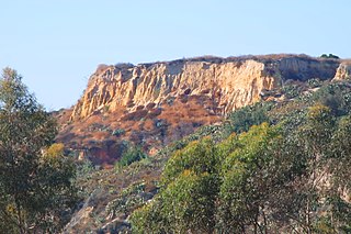
The West Coyote Hills is the area surrounding a ridge in northern Orange County, California. It contains one of the last large open-space area in north Orange County. Parts of it lie within the city limits of La Habra, Buena Park, and La Mirada, with most of it sprawling across western Fullerton between Ralph B. Clark Regional Park and Euclid Street north of Rosecrans Avenue. The foothill region to the east and south is known as Sunny Hills. There is also an East Coyote Hills area, on the east side of Fullerton, that has been almost completely developed for residential real estate.

Blue Lake Regional Park is a public park in Fairview, in the U.S. state of Oregon. The 101-acre (41 ha) park, near the south shore of the Columbia River in Multnomah County, includes many covered and uncovered picnic areas, playing fields for sports such as softball, a cross country course and infrastructure related to lake recreation including swimming, boating, and fishing. Encompassing wooded areas, three ponds, and a wetland in addition to the lake, the park is frequented by migrating birds and other wildlife. Paved paths run through the park, which is near the 40-Mile Loop hiking and biking trail. Park vegetation includes cottonwoods, willows, and other trees and shrubs as well as wetland plants such as cattails.

Rosecrans Avenue is a major west-east thoroughfare in Los Angeles and Orange Counties, California, USA. It has a total length of 27.5 miles (44.3 km). The street is named after U.S. Union General William S. Rosecrans, who purchased 13,000 acres (5,300 ha) of Rancho Sausal Redondo southwest of Los Angeles in 1869. Rosecrans Avenue was originally named Drexel Avenue, and ran through the Rosecrans Rancho which is part of modern-day Gardena.

Coyote Creek is a principal tributary of the San Gabriel River in northwest Orange County and southeast Los Angeles County, California. It drains a land area of roughly 41.3 square miles (107 km2) covering eight major cities, including Brea, Buena Park, Fullerton, Hawaiian Gardens, La Habra, Lakewood, La Palma, and Long Beach. Some major tributaries of the creek in the highly urbanized watershed include Brea Creek, Fullerton Creek, and Carbon Creek. The mostly flat creek basin is separated by a series of low mountains, and is bounded by several small mountain ranges, including the Chino Hills, Puente Hills, and West Coyote Hills.
Big Break Regional Shoreline is a regional park in Oakley, Contra Costa County, northern California. It is a part of the East Bay Regional Park District system.

Bear Creek Regional Park and Nature Center is a regional park located in Colorado Springs, Colorado that has trails for hiking, horseback riding, running and cycling. Within the park is a nature center and the El Paso Park Headquarters.
 Interpretive Center seen across the pond
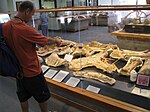
 Pterodactyl sculpture
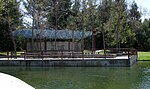 Group picnic shelter
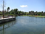 Looking west across the pond
 Northeast section of the perimeter trail