Ram Hill

Last updated

Ram Hill
Ram Hill.JPG
Ram Hill looking towards Henfield
Gloucestershire UK location map.svg
Red pog.svg
Ram Hill
Location within Gloucestershire
Civil parish
Unitary authority
Ceremonial county
Region
Country England
Sovereign state United Kingdom
Post town Bristol
Postcode district BS36
Dialling code 01454
Police Avon and Somerset
Fire Avon
Ambulance South Western
List of places
UK
England
Gloucestershire
51°31′N2°28′W / 51.52°N 02.46°W / 51.52; -02.46

Ram Hill is a hamlet in the civil parish of Westerleigh and Coalpit Heath, in the South Gloucestershire district, in the ceremonial county of Gloucestershire, England. It is located between Coalpit Heath and Westerleigh and adjoins the hamlet of Henfield immediately to the south. In the Mudge Map 1815, Ram Hill was known as Nutridge Hill, and was linked to Westerleigh by Broad Lane and to Mays Hill by Frog Lane. [1]

Contents

Pennant sandstone miners' cottages on Ram Hill Pennant sandstone cottage.JPG
Pennant sandstone miners' cottages on Ram Hill

Ram Hill is a small hamlet that has seen considerable land use change over the recent centuries moving from a traditional agricultural landscape to an active coal mining area by the beginning of the nineteenth century. The population would have increased at that time supported by the introduction of new miner's cottages by the Coalpit Heath Colliery Company.

The closure of Ram Hill Colliery and Churchleaze Pits in the 1860s represented change but the new branch line to the Frog Lane Pit along with the movement of labour to the pit and the nearby Parkfield Colliery would have ensured that the industrial nature of the area was maintained to well into the twentieth century. In 1903 the new Great Western Railway direct route from Badminton to South Wales and the railway sidings at Coalpit Heath Railway Station would also have had an impact.

The growing influence of "horsiculture" on the landscape Landscape at Ram Hill.JPG
The growing influence of "horsiculture" on the landscape

The closure of the Frog Lane Pit at Coalpit Heath in 1949 represented a step change in the area and Ram Hill reverted to its agricultural roots, a dispersed linear settlement, adjoining the London to South Wales railway, surrounded by pastoral agricultural land. There were new additions at that time with further ribbon development consolidating the 1920s/30s "plotlands" developments along the convergent minor roads. Another addition was the introduction of a caravan site at Greenacres.

Ram Hill was peaceful in the 1950s and early 1960s without extensive noise and light pollution. The construction of the M4 Motorway to the south of Henfield in the late 1960s began to change the character of the area and the increasing encroachment of night-time lights highlighted the continuing expansion of Bristol and Yate. In time Ram Hill has lost its rural tranquillity and adopted a new role as a commuter satellite to the main urban areas. At the same time the character of the landscape has changed with dairy farming being replaced by new uses in particular "horsiculture".

Industrial archaeology

Coal mines

Site of Ram Hill Colliery Ram Hill Colliery1.jpg
Site of Ram Hill Colliery

Ram Hill is situated near the centre of the North Bristol Coal Field, this area at one time having been a coal mining community. Coal had been mined in this area since the fourteenth century and most likely even earlier. However it was Sir Samuel Astry, Lord of the Manor of Westerleigh c1680 who started mining on a grander scale and his descendants, or their business partners, continued to be connected with the Coalpit Heath Colliery Company. [1]

Within Ram Hill itself there were four mines operational in the early nineteenth century:

Site of Churchleaze No. 1 Pit (with the Dramway which ran along the boundary on the left-hand side). Site of Churchleaze No. 1 Pit.JPG
Site of Churchleaze No. 1 Pit (with the Dramway which ran along the boundary on the left-hand side).

For the nearby Serridge Engine Pit, Orchard (or Middle Wimsey) Pit, No. 11 Pit and New Engine Pit see Henfield.

The underground map of around 1850 shows that the underground roads of the Ram Hill Colliery and Churchleaze pits on Ram Hill joined together with those of the Serridge Engine and New Engine pits in Henfield. [1]

Dramway

Site of the Dramway at Ram Hill, next to the Coalpit Heath Cricket Club Ram Hill Dramway.JPG
Site of the Dramway at Ram Hill, next to the Coalpit Heath Cricket Club
Dramway Footpath Sign Dramway Footpath Sign.jpg
Dramway Footpath Sign

In the Railway Act of 1828, parliament granted permission to the Avon and Gloucester Railway Company to build a Dramway (horse-drawn railway) from Ram Hill to the River Avon and this section of the Dramway was completed and in use by July 1832. The Ram Hill Colliery was the northern terminus of the Dramway and to the south of Bitterwell Lake there was also a southern spur to New Engine Pit in Henfield. [6]

This early tramway scheme was designed to provide transport from the mines of Coalpit Heath to the wharves on the Avon at Keynsham which supplied both Bristol and Bath. [6] The Dramway was built as a single track railway, built to a standard 4 ft 8in gauge, with passing places along the route. The whole length of the railway was built on a down hill gradient dropping 225 ft along the route. [1] It lasted only nine years before a steam railway connected the pits. [7]

Railways

The site of Coalpit Heath Railway Station and goods yard sidings now part of Ram Hill Business Park Site of Coalpit Heath Railway Station.JPG
The site of Coalpit Heath Railway Station and goods yard sidings now part of Ram Hill Business Park

Soon after the horse-drawn tramway was in operation pressure built up to convert the line to accommodate steam driven locomotives as the Great Western Railway (GWR) were keen to build a 7 ft gauge line from Bristol to Gloucester. The Bristol and Gloucester Company under the influence of the GWR started to convert the 4 ft 8in tramway to a 7 ft railway on 5 June 1844 and this was completed by 9 July. However the colliery owners at Coalpit Heath still had the right to transport their coal in 4 ft 8in trucks and the section of Dramway from Bitterwell Lake to Mangotsfield North Junction was the first dual gauge railway in the country. Another twist was that the line was sold to the Midland Railway in 1845 rather than to the GWR. [6]

In the 1st edition (1881) Ordnance Survey Map it shows that the southern branch of the railway line finishes at the New Engine Pit at Henfield, the centre branch having served Ram Hill Colliery. In around 1860 a northern branch was constructed near Boxhedge Farm that served the new Frog Lane Pit at Coalpit Heath. [6] This line remained operational for almost 90 years until the closure of the mine in 1949.

The South Wales Main Line was re-routed following the opening of the Severn Tunnel in 1886. The new route was established in 1903 with the building of what is often known as the Badminton Line. [8] This involved the construction of about 33 miles of new track, part of which skirted Ram Hill and Coalpit Heath. The Great Western Railway purchased the land at the Ram Hill Colliery site in 1898 and a deep railway cutting was created immediately north of the former mine. [9] To the west the Coalpit Heath Railway Station was opened and goods yard sidings established. The station fell victim to Dr Beeching's cuts and was closed in the 1960s.

Community facilities

Cycle route at Broad Lane Cycle route at Broad Lane.jpg
Cycle route at Broad Lane

Being a small hamlet Ram Hill does not have its own community facilities although the social facilities are available at Coalpit Heath Cricket Club in Serridge Lane. Social and recreational facilities are provided at Henfield Village Hall, Bitterwell Lake and the Newman Field amenity area in the adjoining hamlet of Henfield.

The hamlet is well served with footpaths and cycleways.

Governance

Avon Cycleway sign Avon Cycleway Sign.jpg
Avon Cycleway sign

The two tiers of local government responsible for administering Ram Hill:

Planning

In the adopted South Gloucestershire Local Plan Ram Hill does not have a Defined Settlement Boundary on the Proposals Map and there are no sites allocated for new residential development. [10]

The hamlet is within an area defined as Green Belt and is located within the Forest of Avon area. There are also Major Recreational Routes in the hamlet. [10]

Environment

Landscape

Bluebells at Martin Croft Brake Martin Croft Brake.JPG
Bluebells at Martin Croft Brake

Within the South Gloucestershire Landscape Character Assessment SPD the hamlet of Ram Hill is within an area defined as:

Westerleigh Vale and Oldland Ridge – The Study indicates that Ram Hill, a colliery settlement, and Henfield are small dispersed/linear and clustered hamlets respectively, consisting of a mix of Pennant sandstone with more recent render and brick buildings, focused around a convergence of minor roads and lanes. Around the two settlements are scattered farms.

The area of Ram Hill and Henfield comprises a largely strong, irregular rural framework with areas of woodland, mixed overgrown/clipped hedgerows supplemented with wire fences, defining regular shaped fields. The clustered settlement pattern and non-agricultural activities such as storage compounds, are reasonably well integrated as a result of this framework. Horse paddocks are however locally evident where hedgerows have become replaced with fences. Associated ad hoc home-made stables are also evident and atypical of a rural landscape. Large modern agricultural sheds are prominent within older farm complexes within this area.

The small scale settlement of Ram Hill - well integrated within the framework of hegerow trees Small scale settlement of Ram Hill.JPG
The small scale settlement of Ram Hill – well integrated within the framework of hegerow trees

The small scale settlement at Ram Hill and Henfield is largely well integrated within the framework of hegerow trees and woodland. The area has a generally tranquil character, although the presence of stables and fences associated with the increase in land use change to "horsiculture". modern large farm buildings and storage compounds, can detract from this, visually eroding the rural character and resulting in removal or fragmentation of hedgerows. In places the recreational pressure for "horsiculture" with the associated infrastructure of stables, access tracks, exercise areas, jumps and floodlighting, can result in a change in landscape character. [11]

Biodiversity

One area of Broadleaved Woodland at Ram Hill is identified by South Gloucestershire Council as a Site of Nature Conservation Importance:

There are no Sites of Special Scientific Interest within the hamlet.

Sport and Recreation

Coalpit Heath Cricket Club Coalpit Heath Cricket Club.jpg
Coalpit Heath Cricket Club

Coalpit Heath Cricket Club

Coalpit Heath Cricket Club, situated in Serridge Lane (formerly known as Chuchleaze) at Ram Hill, has well over 100 years of history. It was based for many years at the recreation ground at Coalpit Heath but has relocated to Serridge Lane where a clubhouse has been created which includes social facilities and a skittle alley. The club is a family orientated club running three Senior sides on Saturdays in the Bristol and District Leagues and a Sunday side in the Village Cricket League.

The club also provides facilities for young players to learn and play the game of cricket within their Youth section. The club is affiliated to the Gloucestershire Cricket Board, Bristol & District Cricket Association and Bristol Youth Cricket League. [13]

Mafeking Hall Mafeking Scout Hall Serridge Lane, Ram Hill.jpg
Mafeking Hall

Mafeking Hall

This Scout Hall is located at Serridge Lane, Ram Hill and is run by the Cotswold Edge District Scout Council. Both the Hall and Tullett Field are available for hire.

Economy

Education

The hamlet is served by The Manor C of E Primary School, Coalpit Heath, a primary school catering for pupils aged 5–11. [14]

Older children attend The Ridings Federation Winterbourne International Academy.

Transport

Ram Hill is served by one bus service:

Notable former resident

Location grid

Related Research Articles

<span class="mw-page-title-main">South Gloucestershire</span> District in England

South Gloucestershire is a unitary authority area in the ceremonial county of Gloucestershire, South West England. Towns in the area include Yate, Chipping Sodbury, Thornbury, Filton, Patchway and Bradley Stoke. The southern part of its area falls within the Greater Bristol urban area surrounding the city of Bristol.

<span class="mw-page-title-main">Kingswood, South Gloucestershire</span> Town in Gloucestershire, England

Kingswood is a town and civil parish in the South Gloucestershire district of the ceremonial county of Gloucestershire, England. The town is situated 3 miles (4.8 km) east-northeast of Bristol.

<span class="mw-page-title-main">Westerleigh</span> Human settlement in England

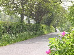
Westerleigh is a clustered village in the civil parish of Westerleigh and Coalpit Heath in the South Gloucestershire district, in the ceremonial county of Gloucestershire, England, it contains sources of the Frome and has an endpoint of the Frome Valley Walkway. It is 0.8 miles (1.3 km) north of the M4, 1 mile (1.6 km) south of Yate and 10 miles (16 km) north-east of the city of Bristol. In the south it includes a steep hill of its own 5 miles (8.0 km) from the crest of the Cotswold hills which is designated an AONB.

<span class="mw-page-title-main">Coalpit Heath</span> Human settlement in England

Coalpit Heath is a small village in the civil parish of Westerleigh and Coalpit Heath, in the South Gloucestershire district, in the ceremonial county of Gloucestershire, England, south of Yate and east of Frampton Cotterell.

<span class="mw-page-title-main">Northavon (UK Parliament constituency)</span>

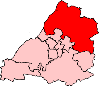
Northavon was, from 1983 until 2010, a constituency represented in the House of Commons of the Parliament of the United Kingdom. It elected one Member of Parliament (MP) by the first past the post system of election.

<span class="mw-page-title-main">Frampton Cotterell</span> Human settlement in England

Frampton Cotterell is a large village and parish, in South Gloucestershire, South West England, on the River Frome. The village is contiguous with Winterbourne to the south-west and Coalpit Heath to the east. The parish borders Iron Acton to the north and Westerleigh to the south-east, the large town of Yate is 2.1 miles (3.4 km) away. The village is 7.5 miles (12 km) north-east of the city of Bristol.

The Bristol and Gloucester Railway was a railway company opened in 1844 to run services between Bristol and Gloucester. It was built on the 7 ftBrunel gauge, but it was acquired in 1845 by the 4 ft 8+12 instandard gauge Midland Railway, which also acquired the Birmingham and Gloucester Railway at the same time.
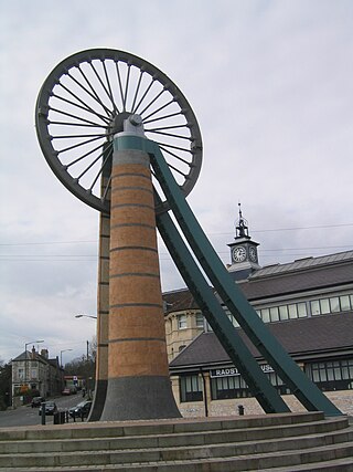
<span class="mw-page-title-main">Gresford</span> Village in Wales

Gresford is a village and community in Wrexham County Borough, Wales.

<span class="mw-page-title-main">Emersons Green</span> Human settlement in England

Emersons Green is a suburb of Bristol and parish in the unitary authority of South Gloucestershire. Sitting 7 miles northeast of Bristol, England. It was developed from farming land during the 1990s and early 21st century, and sits within the historic parish of Mangotsfield.

<span class="mw-page-title-main">Somerset Coalfield</span> Coalfield in northern Somerset, England

The Somerset Coalfield in northern Somerset, England is an area where coal was mined from the 15th century until 1973. It is part of a larger coalfield which stretched into southern Gloucestershire. The Somerset coalfield stretched from Cromhall in the north to the Mendip Hills in the south, and from Bath in the east to Nailsea in the west, a total area of about 240 square miles (622 km2). Most of the pits on the coalfield were concentrated in the Cam Brook, Wellow Brook and Nettlebridge Valleys and around Radstock and Farrington Gurney. The pits were grouped geographically, with clusters of pits close together working the same coal seams often under the same ownership. Many pits shared the trackways and tramways which connected them to the Somerset Coal Canal or railways for distribution.

<span class="mw-page-title-main">Ram Hill Colliery</span>

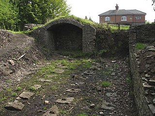
Ram Hill Colliery, was a privately owned colliery in the Coalpit Heath area north-east of Bristol, England. It operated between about 1825 and 1865.

Parkfield Colliery, near Pucklechurch, South Gloucestershire, was sunk in 1851 under the ownership of Handel Cossham. Coal was reached in 1853. The shaft was 840 ft deep, but only the upper series of coal veins were worked. These were the Hard, the Top, the Hollybush and Great veins. The quality of the coal mined was extremely good, and was used for gas manufacture and house coal.

<span class="mw-page-title-main">Siston Hill Colliery</span>

The sinking date for Siston Hill Colliery, Siston, Bristol is unknown, but was probably in the late 1790s or early 19th century. There is a surviving accident report dated 1804. This names the colliery owner as a Mrs. Peterson. By 1831 the colliery was under the ownership of Toghill & Company.

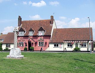
Mayshill or Mays Hill is a hamlet located in the Parish of Westerleigh, South Gloucestershire, England. It is located just off the A432 between Coalpit Heath and Nibley. A small road runs from the hamlet to Frampton End Road, connecting Frampton Cotterell and Iron Acton. Yate and Westerleigh are also nearby. Despite its size the hamlet contains a pub, dating from the 16th Century. The 'New Inn at Mays Hill', on Badminton Road, there is also a house opposite the pub dating from the 17th Century. Mayshill Cemetery, is located across Badminton Road

<span class="mw-page-title-main">Henfield, Gloucestershire</span> Human settlement in England

Henfield is a hamlet in the civil parish of Westerleigh and Coalpit Heath, in the South Gloucestershire district, in the ceremonial county of Gloucestershire, England. It is between Coalpit Heath and Westerleigh, adjoining the hamlet of Ram Hill immediately to the north.

<span class="mw-page-title-main">Siston Brook</span> River in England

Siston Brook rises in two separate streams which issue from a ridge just north of the village of Siston, South Gloucestershire, England. The brook is approximately 6 miles (9.7 km) long and is a tributary of the Bristol Avon. Much of its course is through the eastern suburbs of Bristol, although it remains outside the city boundaries. Tributaries include the Warmley Brook and an unnamed tributary from Bridgeyate.

Fletcher, Burrows and Company was a coal mining company that owned collieries and cotton mills in Atherton, Greater Manchester, England. Gibfield, Howe Bridge and Chanters collieries exploited the coal mines (seams) of the middle coal measures in the Manchester Coalfield. The Fletchers built company housing at Hindsford and a model village at Howe Bridge which included pithead baths and a social club for its workers. The company became part of Manchester Collieries in 1929. The collieries were nationalised in 1947 becoming part of the National Coal Board.

The Bristol and Gloucestershire Railway was an early mineral railway, opened in two stages in 1832 and 1834, which connected collieries near Coalpit Heath with Bristol, at the river Avon. Horse traction was used. It was later taken over by the Bristol and Gloucester Railway, and much of the route became part of the main line between Birmingham and Bristol, though that was later by-passed and closed. Part of it now forms the Bristol and Bath Railway Path.

<span class="mw-page-title-main">Avon and Gloucestershire Railway</span>

The Avon and Gloucestershire Railway also known as The Dramway was an early mineral railway, built to bring coal from pits in the Coalpit Heath area, north-east of Bristol, to the River Avon opposite Keynsham. It was dependent on another line for access to the majority of the pits, and after early success, bad relations and falling traffic potential dogged most of its existence.

Mainsforth Colliery was situated between Ferryhill and the small hamlet of Mainsforth in County Durham, England, United Kingdom. It was adjacent to the former Ferryhill railway station in the Ferryhill Station area of the town.

References

  1. 1 2 3 4 "Ram Hill Colliery – Site Report and Conservation Plan" (PDF). South Gloucestershire Council. Archived from the original (PDF) on 27 September 2011. Retrieved 8 March 2011.
  2. 1 2 3 "The Dramway – The old horse drawn railway path from Coalpit Heath to Willsbridge" (PDF). Ross Barber. Archived from the original (PDF) on 18 March 2012. Retrieved 11 March 2011.
  3. Southway, MJH, ed. (1971). Kingswood Coal Part 2, in the magazine of Bristol Industrial Archaeology Society Vol 5. p. 115.
  4. 1 2 "Scheduled Ancient Monument Notification – Ram Hill Colliery and Dramway" (PDF). English Heritage. Retrieved 11 March 2011.
  5. "The Ram Hill Colliery site". Winterbourne – South Gloucestershire. Retrieved 11 March 2011.
  6. 1 2 3 4 "The Dramway – The old horse drawn railway path from Coalpit Heath to Willsbridge" (PDF). Ross Barber. Archived from the original (PDF) on 18 March 2012. Retrieved 8 March 2011.
  7. "South Gloucestershire Mines Research Group" . Retrieved 8 March 2011.
  8. Kevin Robertson and David Abbott (1988). GWR The Badminton Line – A portrait of a railway. Sutton Publishing Ltd. ISBN   978-0-86299-459-4.
  9. "Ram Hill Colliery – Site Report and Conservation Plan" (PDF). South Gloucestershire Council. Archived from the original (PDF) on 27 September 2011. Retrieved 11 March 2011.
  10. 1 2 "South Gloucestershire Council – South Gloucestershire Local Plan (2006) – Proposals Map" (PDF). Retrieved 27 February 2011.
  11. "South Gloucestershire Landscape Character Assessment" (PDF). South Gloucestershire Council. Archived from the original (PDF) on 19 July 2011. Retrieved 9 March 2011.
  12. "South Gloucestershire Council" (PDF). Archived from the original (PDF) on 18 March 2012. Retrieved 8 March 2011.
  13. "Coalpit Heath Cricket Club" . Retrieved 11 March 2011.
  14. "The Manor C of E Primary School, Coalpit Heath" . Retrieved 9 March 2011.
  15. "South Gloucestershire 686". Archived from the original on 18 July 2011. Retrieved 8 March 2011.