Winterbourne, Gloucestershire

Last updated

Winterbourne
St Michael Winterbourne2.jpg
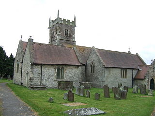
The Parish church of St Michael the Archangel.
Gloucestershire UK location map.svg
Red pog.svg
Winterbourne
Location within Gloucestershire
Population10,250 (2021 Census) [1]
OS grid reference ST647807
Civil parish
  • Winterbourne
Unitary authority
Ceremonial county
Region
Country England
Sovereign state United Kingdom
Post town BRISTOL
Postcode district BS16, BS36
Dialling code 01454
Police Avon and Somerset
Fire Avon
Ambulance South Western
UK Parliament
List of places
UK
England
Gloucestershire
51°31′28″N2°30′16″W / 51.52445°N 2.50447°W / 51.52445; -2.50447 Coordinates: 51°31′28″N2°30′16″W / 51.52445°N 2.50447°W / 51.52445; -2.50447

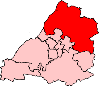
Winterbourne is a large village in South Gloucestershire, England, situated just beyond the north fringe of Bristol. [2] The village had a population of 8,965 according to the 2011 census. This has risen to 10,250 at the 2021 Census. [3] The Civil Parish of Winterbourne is centred on the village and includes the neighbouring communities of Winterbourne Down, Hambrook and Frenchay. To the north-east is the village of Frampton Cotterell and to the west lies the new town of Bradley Stoke.

Contents

Winterbourne was recorded in the Domesday Book as Wintreborne, meaning 'Winter Stream'. [4] The village is believed to have derived its name from the nearby Bradley Brook as much of medieval Winterbourne was originally built up around St Michael's Church, which is situated near the river.

St Michael's Church St Michaels Winterbourne.jpg
St Michael's Church

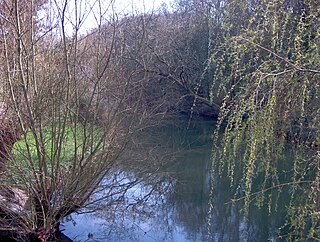
The modern village is largely built on top of a hill, with woodlands and fields encompassing its urban features. The River Frome flows through a valley between the village and nearby Frampton Cotterell, continuing on towards Frenchay, and eventually draining via Mylne's Culvert, into the tidal Bristol Avon New Cut, to the east of what is now Gaol Ferry Bridge. The Bradley Brook divides Winterbourne from Bradley Stoke and Stoke Gifford to the west, before flowing into the Frome at Hambrook. Since the 1960s, the M4 motorway has bypassed the village to the southwest.

Looking towards the Huckford Viaduct and Frome Valley from Cloisters Huckford Viaduct 2.jpg
Looking towards the Huckford Viaduct and Frome Valley from Cloisters
The village pond, home to ducks and swans. Shelter for the ducks is provided on the islands. Pond at Winterbourne, Somerset, England.jpg
The village pond, home to ducks and swans. Shelter for the ducks is provided on the islands.

The Huckford Viaduct carries the Great Western Railway over the River Frome. Beneath the viaduct is the abandoned Huckford Quarry, a public nature reserve. Winterbourne is known for its large duck pond,[ citation needed ] which overlooks the Frome Valley and is a common spot for fishing and feeding the ducks and swans.[ citation needed ]

The parish church is St Michael's, a building dating from the 12th century, which celebrated its 800th anniversary in 1998. St Michael's sits amid fields, flanked by cottages, with its prominent spire visible for miles around. At the altar is a stone depiction of the Last Supper , based on the painting by Leonardo da Vinci. Winterbourne Court Farm Barn is immediately adjacent to the church. This is a grade II* listed 14th century tithe barn and is an outstanding example of its type.[ citation needed ]

Winterbourne has a number of pubs including the George and Dragon, the Swan and the Mason's Arms. In recent years,[ when? ] a number of the village's pubs have become restaurants; two of which now serve Indian cuisine. The village has three social hubs: St Michael's Rooms, Fromeside Community Centre and Greenfield, which host clubs, functions and other public events.

The High Street Winterbourne main street arp.jpg
The High Street

Winterbourne contains branches of the Co-op and Tesco Express, a chemist, optician, a handful of dental practices and a library. Other village amenities include a bakery, butcher and a Post Office serving the community. Horses and cattle are a common sight in the fields, including in the Cloisters area, which has views of the Frome Valley and the Huckford Viaduct.

As well as being the centre of a large civil parish, Winterbourne contains the hamlet of Watley's End, located on the border between Winterbourne and Frampton Cotterell. Nowadays, it is regarded as an area of Winterbourne, but a few decades ago[ when? ] it was considered to be a village in its own right. Some people in Watley's End continue to refer to the busy, uphill part of the village as 'Winterbourne Hill'.[ citation needed ] Salem, the local Methodist church, is in Watley's End.

Governance

An electoral ward in the same name exists. This ward stretches from Winterbourne in the north west to Hambrook in the southeast. The total population of the ward taken at the 2011 census was 6,994. [5]

Schools

Winterbourne contains several schools. The main primary schools are Elm Park and St Michael's, with most students going on to attend the nearby secondary school, Winterbourne Academy, originally named The Ridings High School when formally opened by Tony Benn in 1957. Silverhill School and Day Nursery is an independent preparatory school for children aged 6 months to 11 years. St Michael's was founded in 1813 by the abolitionists and educational reformers, Hannah More and William Wilberforce. The original school was located upstairs in the George and Dragon pub. Larger rooms were then provided in Bourne House, where the school remained until a permanent building was erected on the High Street. St Michael's present location on Linden Close was opened in 1970. [6] St Michael's alumna, J. K. Rowling, [7] is reputed to have based much of her character, Albus Dumbledore, on Alfred Dunn, who was headmaster during her studies. [8]

Notable residents

Sport and leisure

Winterbourne has a Non-League football club Winterbourne United F.C. who play at Parkside Avenue and a popular village cricket club that fields 5 senior sides - Winterbourne CC - who share the same ground. Winterbourne Down Border Morris performs during the year at events such as wassailing, and especially on Boxing Day when they perform a Mummers play. [14]

Location grid

Related Research Articles

<span class="mw-page-title-main">South Gloucestershire</span> Unitary authority area in England

South Gloucestershire is a unitary authority area in the ceremonial county of Gloucestershire, South West England. Towns in the area include Yate, Chipping Sodbury, Thornbury, Filton, Patchway and Bradley Stoke, the latter three forming part of the northern Bristol suburbs. The unitary authority also covers many outlying villages and hamlets. The southern part of its area falls within the Greater Bristol urban area surrounding the city of Bristol.

<span class="mw-page-title-main">Stratton, Dorset</span> Village in Dorset, England

Stratton is a village and civil parish in Dorset, England, situated in the Frome valley about 3 miles (4.8 km) north-west of Dorchester. The parish includes the hamlets of Grimstone, Ash Hill and Wrackleford which, like the village, lie on or near the A37 trunk road. Ash Hill is a small estate east of the village near the railway. Wrackleford is a group of houses further east and centred about Wrackleford House and including Higher Wrackleford and Lower Wrackleford. In addition there are a number of isolated farms and houses including a few in an area called Langford near the Sydling Water in the north-west part of the parish.

<span class="mw-page-title-main">River Frome, Bristol</span> River in south west England

The Frome, historically the Froom, is a river that rises in Dodington Park, South Gloucestershire, and flows southwesterly through Bristol to join the river Avon. It is approximately 20 miles (32 km) long, and the mean flow at Frenchay is 60 cubic feet per second (1.7 m3/s). The name Frome is shared with several other rivers in South West England and means 'fair, fine, brisk'. The river is known locally in east Bristol as the Danny.

<span class="mw-page-title-main">Stoke Gifford</span> Human settlement in England

Stoke Gifford is a village and parish in South Gloucestershire, England. It had around 11,000 residents at the 2001 census, increasing to 15,494 at the 2011 census and then to 19,794 in the 2021 Census.

<span class="mw-page-title-main">Northavon (UK Parliament constituency)</span>

Northavon was, from 1983 until 2010, a constituency represented in the House of Commons of the Parliament of the United Kingdom. It elected one Member of Parliament (MP) by the first past the post system of election.

<span class="mw-page-title-main">Frampton Cotterell</span> Human settlement in England

Frampton Cotterell is a large village and parish, in South Gloucestershire, South West England, on the River Frome. The village is contiguous with Winterbourne to the south-west and Coalpit Heath to the east. The parish borders Iron Acton to the north and Westerleigh to the south-east, the large town of Yate is 2.1 miles (3.4 km) away. The village is 7.5 miles (12 km) north-east of the city of Bristol.

<span class="mw-page-title-main">Hambrook</span> Human settlement in England

Hambrook is a village in South Gloucestershire, England, situated on the north-eastern outskirts of the city of Bristol. It lies between the larger communities of Winterbourne and Frenchay and is part of the Civil Parish of Winterbourne.

<span class="mw-page-title-main">Diocese of Bristol</span> Diocese of the Church of England

The Diocese of Bristol is an ecclesiastical jurisdiction or diocese of the Church of England in the Province of Canterbury, England. It is based in the city of Bristol and covers South Gloucestershire and parts of north Wiltshire, as far east as Swindon. The diocese is headed by the Bishop of Bristol and the Episcopal seat is located at the Cathedral Church of the Holy and Undivided Trinity, commonly known as Bristol Cathedral.

<span class="mw-page-title-main">Frenchay</span> Human settlement in England

Frenchay is a village in the County of South Gloucestershire, England, and the Civil Parish of Winterbourne. It is on the outskirts to the north east of the city of Bristol.

<span class="mw-page-title-main">Filton and Bradley Stoke (UK Parliament constituency)</span>

Filton and Bradley Stoke is a constituency represented in the House of Commons of the UK Parliament since 2010 by Jack Lopresti, a Conservative.

<span class="mw-page-title-main">Winterbourne United F.C.</span> Association football club in England

Winterbourne United Football Club is a football club based in Winterbourne, near Bristol, England. Affiliated to the Gloucestershire County FA, they are currently members of the Bristol Premier Combination Premier Division.

<span class="mw-page-title-main">Frome Valley Walkway</span>

The Frome Valley Walkway is an 18-mile (29 km) footpath which follows the River Frome from the River Avon in the centre of Bristol to the Cotswold Hills in South Gloucestershire. The path also links the Cotswold Way National Trail at one end with the Avon Walkway at the other.

<span class="mw-page-title-main">Winterbourne Down, Gloucestershire</span>

Winterbourne Down is a village in South Gloucestershire, England, located on the north-eastern outskirts of Bristol. It is also part of the Civil Parish of Winterbourne. It is demarcated by the Avon Ring Road to the south. The Parish's annual May Day carnival is held here.

The city of Bristol, England, is divided into many areas, which often overlap or have non-fixed borders. These include Parliamentary constituencies, council wards and unofficial neighbourhoods. There are no civil parishes in Bristol.

<span class="mw-page-title-main">Watley's End</span>

Watley's End was a small village located in South Gloucestershire, England. It now forms the northern part of Winterbourne. Watley's End Road, which runs through the village, would have been the main road.

<span class="mw-page-title-main">St Michael's Church, Winterbourne</span> Building in Bristol, England

St Michael the Archangel Church or simply St Michael's Church is an Anglican parish church located in Winterbourne, South Gloucestershire, on the northern fringe of Bristol. It was built in the 12th century and has been designated by English Heritage as a grade I listed building.

<span class="mw-page-title-main">Langley and Swinehead Hundred</span>

Langley and Swinehead was an ancient hundred of Gloucestershire, England. Hundreds originated in the late Saxon period as a subdivision of a county and lasted as administrative divisions until the 19th century.

References

  1. "WINTERBOURNE". City population. Retrieved 25 October 2022.
  2. OS Explorer Map, Bristol and Bath, Keynsham & Marshfield. Scale: 1:25 000.Publisher: Ordnance Survey B4 edition (2013). ISBN   978 0319239773
  3. "Winterbourne (Parish, United Kingdom) - Population Statistics, Charts, Map and Location".
  4. ISBN   0-19-852758-6 Oxford Dictionary of British Place Names
  5. "ward population 2011" . Retrieved 21 March 2015.
  6. Winterbourne Family History Online, St Michael's School Admission Register 1966–1970 – Accessed 14 August 2006.
  7. Winterbourne Family History Online, St Michael’s School Admission Register 1966–1970 – Rowling listed as admission No.305. Accessed 14 August 2006.
  8. Winterbourne, South Gloucestershire Community Information and Magazine, Winterbourne, Harry Potter and Albus Dumbledore!. Accessed 8 August 2009.
  9. "Cllr Tim Bowles". Bristol and South Gloucestershire Conservatives. Retrieved 6 May 2017.
  10. Dictionary of National Biography, 1885-1900, Volume 11, Colston, Edward Author: William Hunt. Accessed 28 February 2017.
  11. "Ambition for the West of England" (PDF). Labour Party. 2021. Retrieved 18 July 2021.
  12. St Michael's School Admission Register 1966–1970 – Rowling listed as admission No.305. Accessed 14 August 2006.
  13. "Edinburgh "cub reporter" press conference, ITV, 16 July 2005". Quick Quotes Quill. Archived from the original on 6 January 2007. Retrieved 29 June 2007.
  14. "Winterbourne Down Border Morris".