Rancho Tehama, California

Last updated

Rancho Tehama, California
Tehama County California Incorporated and Unincorporated areas Rancho Tehama Reserve Highlighted.svg
Location in Tehama County and the state of California
Usa edcp location map.svg
Red pog.svg
Rancho Tehama, California
Location in the United States
USA California location map.svg
Red pog.svg
Rancho Tehama, California
Rancho Tehama, California (California)
Coordinates: 40°0′29″N122°25′33″W / 40.00806°N 122.42583°W / 40.00806; -122.42583 [1]
Country United States
State California
County Tehama
Area
[2]
  Total11.717 sq mi (30.345 km2)
  Land11.639 sq mi (30.144 km2)
  Water0.078 sq mi (0.201 km2)  0.66%
Elevation
[1]
525 ft (160 m)
Population
 (2020) [3]
  Total1,572
  Density130/sq mi (52/km2)
Time zone UTC-8 (Pacific (PST))
  Summer (DST) UTC-7 (PDT)
ZIP codes
96021, 96080
Area code 530
FIPS code 06-59604 [1]
GNIS ID 2413663 [1]
Website Official website OOjs UI icon edit-ltr-progressive.svg

Rancho Tehama, also known as the Rancho Tehama Reserve, is an unincorporated community in Tehama County, California, United States. [1] As of the 2020 census, the population of the community and nearby areas was 1,572. [3] The lightly populated rural, remote community has large lots where some residents farm olives, walnuts and almonds. [4]

Contents

History

2017 shooting spree

During a shooting spree on November 13-14, five people were killed and eighteen others were injured at eight separate crime scenes, including an elementary school. Ten people suffered bullet wounds and eight were cut by flying glass caused by the gunfire. The gunman, Kevin Janson Neal, died by suicide after a Corning police officer rammed and stopped his stolen vehicle. [5]

Geography

According to the United States Census Bureau, the CDP has a total area of 11.7 square miles (30 square kilometres), of which, 11.6 square miles (30 km2) of it is land and 0.1 square miles (0.26 km2) of it (0.66%) is water. The census definition of the area may not precisely correspond to local understanding of the area with the same name.

Rancho Tehama Airport, National Geographic Names Database feature ID 1653862, is located at 40°00′57″N122°23′23″W / 40.01583°N 122.38972°W / 40.01583; -122.38972 in the same vicinity as other references to the community.

Demographics

Historical population
CensusPop.Note
2000 1,406
2010 1,4855.6%
2020 1,5725.9%
U.S. Decennial Census

For statistical purposes, the United States Census Bureau has defined Rancho Tehama Reserve as a census-designated place (CDP), which includes population from the surrounding area.

2010

At the 2010 census Rancho Tehama had a population of 1,485, an increase from the population of 1,406 recorded in the 2000 census. [6] The population density was 126.7 inhabitants per square mile (48.9/km2). The racial makeup of Rancho Tehama was 1,181 (79.5%) White, 21 (1.4%) African American, 52 (3.5%) Native American, 21 (1.4%) Asian, 5 (0.3%) Pacific Islander, 102 (6.9%) from other races, and 103 (6.9%) from two or more races. Hispanic or Latino of any race were 214 people (14.4%). [7]

The whole population lived in households, no one lived in non-institutionalized group quarters and no one was institutionalized.

There were 587 households, 143 (24.4%) had children under the age of 18 living in them, 289 (49.2%) were married couples, 63 (10.7%) had a female householder with no husband present, 42 (7.2%) had a male householder with no wife present. There were 37 (6.3%) unmarried opposite-sex partnerships, and 1 (0.2%) same-sex married couples or partnerships. 148 households (25.2%) were one person and 57 (9.7%) had someone living alone who was 65 or older. The average household size was 2.53. There were 394 families (67.1% of households); the average family size was 2.96.

The age distribution was 295 people (19.9%) under the age of 18, 110 people (7.4%) aged 18 to 24, 253 people (17.0%) aged 25 to 44, 509 people (34.3%) aged 45 to 64, and 318 people (21.4%) who were 65 or older. The median age was 48.5 years. For every 100 females, there were 100.4 males. For every 100 females age 18 and over, there were 102.7 males.

There were 776 housing units at an average density of 66.2 per square mile, of the occupied units 476 (81.1%) were owner-occupied and 111 (18.9%) were rented. The homeowner vacancy rate was 6.5%; the rental vacancy rate was 6.7%. 1,150 people (77.4% of the population) lived in owner-occupied housing units and 335 people (22.6%) lived in rental housing units.

Government

In the California State Legislature, Rancho Tehama is in the 1st Senate District , represented by Republican Brian Dahle, and in the 3rd Assembly District , represented by Republican James Gallagher. [8]

In the United States House of Representatives, Rancho Tehama is in California's 1st congressional district , represented by Republican Doug LaMalfa. [9]

Related Research Articles

<span class="mw-page-title-main">Tehama County, California</span> County in California, United States

Tehama County is a county located in the northern part of the U.S. state of California. As of the 2020 census, the population was 65,829. The county seat and largest city is Red Bluff.

<span class="mw-page-title-main">East Rancho Dominguez, California</span> Unincorporated community in California, United States

East Rancho Dominguez, also known as East Compton, is an unincorporated community and census-designated place (CDP) located in southern Los Angeles County, California. The population was 15,135 at the 2010 census, up from 9,286 at the 2000 census. East Rancho Dominguez is an accepted city name according to the USPS, and shares the 90221 ZIP Code with Compton.

<span class="mw-page-title-main">West Rancho Dominguez, California</span> Unincorporated community in California, United States

West Rancho Dominguez, formerly known as West Compton, is an unincorporated census-designated place (CDP) located in southern Los Angeles County, California. Per the 2020 census, the population was 24,347. The community lies to the west of the city of Compton. The ZIP Codes encompassing the CDP area are 90220 & 90248.

<span class="mw-page-title-main">West Whittier-Los Nietos, California</span> Census-designated place in California, United States

West Whittier-Los Nietos is a census-designated place (CDP) in Los Angeles County, California, near the San Gabriel River and the San Gabriel River (I-605) Freeway. The population was 25,540 at the 2010 census, up from 25,129 at the 2000 census. The census area consists of separate unincorporated communities of Los Nietos and West Whittier.

<span class="mw-page-title-main">Aromas, California</span> Census-designated place in California, United States

Aromas is an unincorporated community and census-designated place (CDP) in Monterey County and San Benito County, California, United States. The population was 2,708 at the 2020 census.

<span class="mw-page-title-main">Coto de Caza, California</span> Census-designated place in California, United States

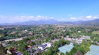
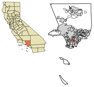
Coto de Caza is a census-designated place (CDP) and guard-gated private community in Orange County, California. The population was 14,710 at the 2020 census.

<span class="mw-page-title-main">Gold River, California</span> Census-designated place in California, United States

Gold River is a census-designated place (CDP) in Sacramento County, California. The population was 7,812 at the 2010 census, down from 8,023 at the 2000 census. Gold River is part of the Sacramento–Arden-Arcade–Roseville Metropolitan Statistical Area. With a median family income of $141,399 according to U.S Census Bureau in 2021, Gold River is the highest-income place in Sacramento County.

<span class="mw-page-title-main">Rancho Murieta, California</span> Census-designated place in California, United States

Rancho Murieta is a census-designated place (CDP) and guard-gated community in Sacramento County, California, United States. It is part of the Sacramento–Arden-Arcade–Roseville Metropolitan Statistical Area. The population was 5,488 at the 2010 census, up from 4,193 at the 2000 census. It is located in the foothills of the Sierra Nevada range, about 25 miles (40 km) east of Sacramento.

<span class="mw-page-title-main">Vandenberg Village, California</span> Census-designated place in California, United States

Vandenberg Village is a census-designated place (CDP) in the unincorporated area of Santa Barbara County, California, United States. The population was 6,497 at the 2010 census, up from 5,802 at the 2000 census.

<span class="mw-page-title-main">Cottonwood, California</span> Census-designated place in the United States

Cottonwood is a census-designated place (CDP) in Shasta County, California, United States. Its population is 6,268 as of the 2020 census, up from 3,316 from the 2010 census. Cottonwood was a stagecoach town where a settlement was established in 1849. The first Post Office was opened in 1852. Cottonwood is equidistant between Redding and Red Bluff, 15 miles (24 km) in either direction. It is 4 miles (6.4 km) south of Anderson.

<span class="mw-page-title-main">Corning, California</span> City in California, United States

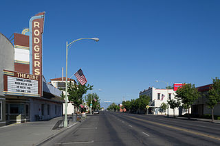
Corning is a city in Tehama County, California, that is located about 19 miles (31 km) south of Red Bluff and about 100 miles (160 km) north of Sacramento. The population was 8,244 at the 2020 census, up from 7,663 at the 2010 census.

<span class="mw-page-title-main">Gerber-Las Flores, California</span> Unincorporated community in California, United States

Gerber-Las Flores is a former census-designated place (CDP) in Tehama County, California, United States. The population was 1,389 at the 2000 census.

<span class="mw-page-title-main">Los Molinos, California</span> Census-designated place in California, United States

Los Molinos is a census-designated place (CDP) in Tehama County, California, United States. The population was 2,037 at the 2010 census, up from 1,952 at the 2000 census.

<span class="mw-page-title-main">Manton, California</span> Census-designated place in California, United States

Manton is a census-designated place (CDP) partially in Tehama County, California, United States. It is also in Shasta County. The population in the Tehama County portion was 347 at the 2010 census, down from 372 at the 2000 census.

<span class="mw-page-title-main">Mineral, California</span> Census designated place in California, United States

Mineral is a boundaried but unincorporated forest village in Tehama County, California, United States. It has been part of a much larger census-designated place since 1980, for which the population was 123 at the 2010 census, down from 143 at the 2000 census.

<span class="mw-page-title-main">Red Bluff, California</span> City in California, United States

Red Bluff is a city in and the county seat of Tehama County, California, United States. The population was 14,710 at the 2020 census, up from 14,076 at the 2010 census.

<span class="mw-page-title-main">Tehama, California</span> City in California, United States

Tehama is a city in Tehama County, California, United States. The population was 418 at the 2010 census, down from 432 at the 2000 census.

<span class="mw-page-title-main">Rancho San Diego, California</span> Census designated place in California, United States

Rancho San Diego is a census-designated place (CDP) in the East County region of San Diego County, California. The population was 21,858 at the 2020 census, up from 21,208 at the 2010 census. The area was developed as subdivisions beginning in the 1970s.

<span class="mw-page-title-main">Bend, California</span> Census-designated place in California, United States

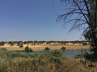
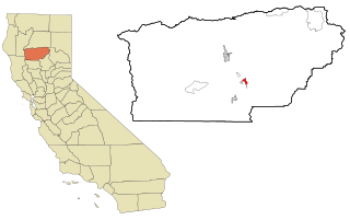
Bend is a census-designated place in Tehama County, California, United States. Bend is located on the Sacramento River 6 miles (9.7 km) north-northeast of Red Bluff. Bend had a post office from 1897 to 1935. The community was originally known as Horsethief Bend; the name was changed to Sander's Bend and later shortened to Bend. The community was named after a nearby meander in the Sacramento River. The population was 619 at the 2010 census.

Las Flores is a census-designated place (CDP) in Tehama County, California. Las Flores sits at an elevation of 249 feet (76 m). The 2010 United States census reported Las Flores's population was 187.

References

  1. 1 2 3 4 5 "Rancho Tehama Reserve", Geographic Names Information System , United States Geological Survey, United States Department of the Interior
  2. "2010 Census U.S. Gazetteer Files – Places – California". United States Census Bureau.
  3. 1 2 "Profile of Rancho Tehama Reserve, California (CDP) in 2020". United States Census Bureau. Retrieved March 16, 2023.
  4. Shyong, Frank; Panzar, Javier; Serna, Joseph; Saint John, Paige (November 14, 2017). "Terror in Northern California town as gunman goes on rampage, sprays school will bullets". Los Angeles Times . Retrieved November 15, 2017.
  5. Saint John, Paige (November 15, 2017). "Gunman's rampage exposes dark 'underbelly' of small Northern California community". Los Angeles Times . Retrieved November 16, 2017.
  6. "U.S. Census website". United States Census Bureau . Retrieved January 31, 2008.
  7. "2010 Census Interactive Population Search: CA – Rancho Tehama Reserve CDP". U.S. Census Bureau. Archived from the original on July 15, 2014. Retrieved July 12, 2014.
  8. "Statewide Database". Regents of the University of California . Retrieved April 20, 2015.
  9. "California's 1st Congressional District - Representatives & District Map". Civic Impulse, LLC. Retrieved March 1, 2013.