Randolph, Minnesota

Last updated

Randolph
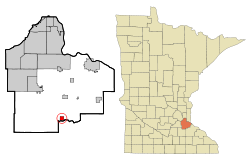
Dakota County Minnesota Incorporated and Unincorporated areas Randolph Highlighted.svg
Location of the city of Randolph
within Dakota County, Minnesota
Coordinates: 44°31′30″N93°1′10″W / 44.52500°N 93.01944°W / 44.52500; -93.01944
Country United States
State Minnesota
County Dakota
Area
[1]
  Total0.98 sq mi (2.54 km2)
  Land0.95 sq mi (2.47 km2)
  Water0.03 sq mi (0.07 km2)
Elevation
879 ft (268 m)
Population
 (2020)
  Total466
  Density488.98/sq mi (188.85/km2)
Time zone UTC-6 (Central (CST))
  Summer (DST) UTC-5 (CDT)
ZIP code
55065
Area code(s) 507, 651
FIPS code 27-53098 [2]
GNIS feature ID0649818 [3]

Randolph is a city in Dakota County, Minnesota, United States. The population was 436 at the 2010 census. [4]

Contents

History

A post office called Randolph has been in operation since 1886. [5] The city took its name from Randolph Township. [6]

Geography

According to the United States Census Bureau, the city has a total area of 1.03 square miles (2.67 km2), of which 0.96 square miles (2.49 km2) is land and 0.07 square miles (0.18 km2) is water. [7]

The city of Randolph is entirely within Randolph Township geographically but is a separate entity.

Lake Byllesby and the Cannon River are both nearby.

Randolph is in the southern part of Dakota County. The boundary line between Dakota, Goodhue, and Rice counties is nearby.

Demographics

Historical population
CensusPop.Note
1910 182
1920 170−6.6%
1930 21425.9%
1940 23610.3%
1950 2599.7%
1960 31521.6%
1970 35011.1%
1980 3510.3%
1990 331−5.7%
2000 318−3.9%
2010 43637.1%
2020 4666.9%
U.S. Decennial Census [8]

2010 census

As of the census [9] of 2010, there were 436 people, 168 households, and 118 families living in the city. The population density was 454.2 inhabitants per square mile (175.4/km2). There were 177 housing units at an average density of 184.4 per square mile (71.2/km2). The racial makeup of the city was 98.4% White, 0.2% Asian, and 1.4% from two or more races. Hispanic or Latino of any race were 1.8% of the population.

There were 168 households, of which 37.5% had children under the age of 18 living with them, 53.6% were married couples living together, 11.3% had a female householder with no husband present, 5.4% had a male householder with no wife present, and 29.8% were non-families. 23.2% of all households were made up of individuals, and 7.8% had someone living alone who was 65 years of age or older. The average household size was 2.60 and the average family size was 3.03.

The median age in the city was 36 years. 27.5% of residents were under the age of 18; 7.8% were between the ages of 18 and 24; 27.7% were from 25 to 44; 29.1% were from 45 to 64; and 7.8% were 65 years of age or older. The gender makeup of the city was 51.1% male and 48.9% female.

2000 census

As of the census [2] of 2000, there were 318 people, 117 households, and 89 families living in the city. The racial makeup of the city was 98.74% White, 0.63% Asian, and 0.63% from two or more races. Hispanic or Latino of any race were 1.26% of the population.

There were 117 households, out of which 38.5% had children under the age of 18 living with them, 65.0% were married couples living together, 6.0% had a female householder with no husband present, and 23.9% were non-families. 22.2% of all households were made up of individuals, and 4.3% had someone living alone who was 65 years of age or older. The average household size was 2.72 and the average family size was 3.13.

In the city, the population was spread out, with 28.9% under the age of 18, 6.6% from 18 to 24, 33.0% from 25 to 44, 20.4% from 45 to 64, and 11.0% who were 65 years of age or older. The median age was 35 years. For every 100 females, there were 101.3 males. For every 100 females age 18 and over, there were 98.2 males.

The median income for a household in the city was $42,750, and the median income for a family was $48,125. Males had a median income of $35,375 versus $25,000 for females. The per capita income for the city was $16,947. About 3.9% of families and 4.3% of the population were below the poverty line, including none of those under age 18 and 13.5% of those age 65 or over.

Roads

State Highway 56, County Road 88 / 292nd Street East, and County Road 83 are main routes in the community.

Nearby routes include U.S. Highway 52, State Highway 19, County Road 47 / Northfield Boulevard, and County Road 86.

Airport

Stanton Airfield is located five miles south of Randolph but is primarily a general aviation airport.

Related Research Articles

<span class="mw-page-title-main">Randolph County, Alabama</span> County in Alabama, United States

Randolph County is a county on the central eastern border of the U.S. state of Alabama. As of the 2020 census, the population was 21,967. Its county seat is Wedowee. Its name is in honor of John Randolph, a member of the United States Senate from Virginia. Randolph County was a prohibition or dry county until 2012, when the citizens of Randolph County voted to repeal prohibition.

<span class="mw-page-title-main">Knightsville, Indiana</span> Town in Indiana, United States

Knightsville is a town in Van Buren Township, Clay County, Indiana, United States. The population was 872 at the 2010 census. It is part of the Terre Haute Metropolitan Statistical Area.

<span class="mw-page-title-main">Ashley, Indiana</span> Town in Indiana, United States

Ashley is a town in Indiana located on the border of Smithfield Township, DeKalb County and Steuben Township, Steuben County. The population was 983 at the 2010 census.

<span class="mw-page-title-main">Dakota City, Iowa</span> City in Iowa, United States

Dakota City is a city in and the county seat of Humboldt County, Iowa, United States. The population was 759 at the time of the 2020 census. Dakota City shares its western border with the much larger city of Humboldt. It is the least populous county seat in Iowa.

Randolph Township is a township in Dakota County, Minnesota, United States. The population was 536 at the 2000 census.

<span class="mw-page-title-main">Dakota, Minnesota</span> City in Minnesota, United States

Dakota is a city in Winona County, Minnesota, United States. The population was 295 at the 2020 census.

<span class="mw-page-title-main">Hettinger, North Dakota</span> City in North Dakota, United States

Hettinger is a city in, and the county seat of, Adams County, North Dakota, United States. The population was 1,074 at the 2020 census.

<span class="mw-page-title-main">Lakota, North Dakota</span> City in North Dakota, United States

Lakota is a city in Nelson County, North Dakota, United States. It is the county seat of Nelson County Lakota is located 63 miles west of Grand Forks and 27 miles east of Devils Lake. The population was 683 at the 2020 census, making Lakota the 76th-largest city in North Dakota.

<span class="mw-page-title-main">Tyndall, South Dakota</span> City in South Dakota, United States

Tyndall is a city in and the county seat of Bon Homme County, South Dakota, United States. The population was 1,057 at the 2020 census.

<span class="mw-page-title-main">Chamberlain, South Dakota</span> City in South Dakota, United States

Chamberlain is a city in Brule County, South Dakota, United States. It is located on the east bank of the Missouri River, at the dammed section of the Lake Francis Case, close to where it is crossed by Interstate 90.

<span class="mw-page-title-main">Wagner, South Dakota</span> City in South Dakota, United States

Wagner is a city in Charles Mix County, South Dakota, United States. The population was 1,490 at the 2020 census. The city is served by Wagner Municipal Airport as well as YST Transit buses.

<span class="mw-page-title-main">Webster, South Dakota</span> City in South Dakota, United States

Webster is a city in and the county seat of Day County, South Dakota, United States. The population was 1,728 at the 2020 census.

<span class="mw-page-title-main">Clear Lake, South Dakota</span> City in South Dakota, United States

Clear Lake is a city in and the county seat of Deuel County, South Dakota, United States. The population was 1,218 at the 2020 census.

<span class="mw-page-title-main">Miller, South Dakota</span> City in South Dakota, United States

Miller is a city in and county seat of Hand County, South Dakota, United States. The population was 1,349 at the 2020 census.

<span class="mw-page-title-main">Alexandria, South Dakota</span> City in South Dakota, United States

Alexandria is a city in central Hanson County, South Dakota, United States. The population was 649 at the 2020 census. It is the county seat of Hanson County.

<span class="mw-page-title-main">Kadoka, South Dakota</span> City in South Dakota, United States

Kadoka is a city in, and the county seat of, Jackson County, South Dakota, United States. The population was 543 at the 2020 census. The town occupies about 2.3 square miles.

<span class="mw-page-title-main">Leola, South Dakota</span> City in South Dakota, United States

Leola is a small city in, and the county seat of, McPherson County, South Dakota, United States. It was founded on May 1, 1884, and named for Leola Haynes, daughter of one of the town's founders. The population was 434 as of the 2020 census.

<span class="mw-page-title-main">Hartford, South Dakota</span> City in South Dakota, United States

Hartford is a suburban American city in Minnehaha County, South Dakota, a few miles northwest of Sioux Falls. Its population was 3,354 at the 2020 census.

<span class="mw-page-title-main">Parker, South Dakota</span> City in South Dakota, U.S.

Parker is a city in Turner County, South Dakota, United States. The population was 1,194 at the 2020 census. It is the county seat of Turner County. Parker is bordered on its eastern side by South Dakota State Highway 19. Its northern side is bordered by South Dakota State Highway 44. Parker is located approximately 8 miles (13 km) northwest of Chancellor, 42 miles (68 km) east of Parkston and 41 miles (66 km) south of Madison.

<span class="mw-page-title-main">Waterville, Wisconsin</span> Town in Wisconsin, United States

Waterville is a town in Pepin County, Wisconsin, United States. The population was 829 at the 2020 census. The unincorporated community of Arkansaw is located within the eastern portion of the town.

References

  1. "2020 U.S. Gazetteer Files". United States Census Bureau. Retrieved July 24, 2022.
  2. 1 2 "U.S. Census website". United States Census Bureau . Retrieved January 31, 2008.
  3. "US Board on Geographic Names". United States Geological Survey. October 25, 2007. Retrieved January 31, 2008.
  4. "2010 Census Redistricting Data (Public Law 94-171) Summary File". American FactFinder. United States Census Bureau . Retrieved April 27, 2011.[ dead link ]
  5. "Dakota County". Jim Forte Postal History. Retrieved May 10, 2015.
  6. Upham, Warren (1920). Minnesota Geographic Names: Their Origin and Historic Significance. Minnesota Historical Society. p.  167.
  7. "US Gazetteer files 2010". United States Census Bureau. Archived from the original on July 2, 2012. Retrieved November 13, 2012.
  8. "Census of Population and Housing". Census.gov. Retrieved June 4, 2015.
  9. "U.S. Census website". United States Census Bureau . Retrieved November 13, 2012.

44°31′34″N93°01′12″W / 44.52611°N 93.02000°W / 44.52611; -93.02000