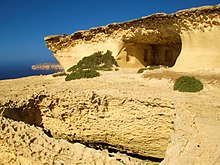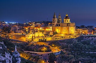
Mellieħa is a large village in the Northern Region of Malta. It has a population of 10,087 as of March 2014. Mellieħa is also a tourist resort, popular for its sandy beaches, natural environment, and Popeye Village nearby.
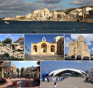
St. Paul's Bay is a town in the Northern Region of Malta, sixteen kilometres northwest of the capital Valletta. Saint Paul's Bay is the largest town in the Northern Region and the seat of the Northern Regional Committee. It is the most populous settlement in Malta.
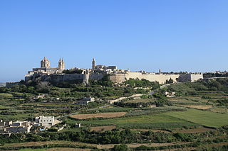
Mdina, also known by its Italian-language titles Città Vecchia and Città Notabile, is a fortified city in the Northern Region of Malta which served as the island's capital from antiquity to the medieval period. The city is still confined within its walls, and has a population of 250, but it is contiguous with the town of Rabat, which takes its name from the Arabic word for suburb, and has a population of over 11,000.

Gudja is a village in the Southern Region of Malta, with a population of 3,148 as of March 2017. The village is located on high grounds, south of Valletta. It is administered by the Gudja Local Council. A number of schools, clubs, public gardens and recreations places are found around the village.
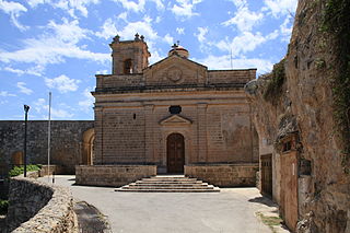
The Sanctuary of Our Lady of Mellieħa is a Roman Catholic church in the village of Mellieħa in Malta. The sanctuary originated as a natural cave which was consecrated as a church at an unknown date, and local traditions link its establishment to antiquity or the medieval period. The church's altarpiece is a Byzantine-style fresco which is believed to date back to the late 12th or early 13th centuries, and it is said to be miraculous.

The Hypogeum of Ħal Saflieni is a Neolithic subterranean structure dating to the Saflieni phase in Maltese prehistory, located in Paola, Malta. It is often simply referred to as the Hypogeum, literally meaning "underground" in Greek. The Hypogeum is thought to have been a sanctuary and necropolis, with the estimated remains of more than 7,000 people documented by archeologists, and is among the best preserved examples of the Maltese temple building culture that also produced the Megalithic Temples and Xagħra Stone Circle.

The Xagħra Stone Circle, also known as the Xagħra Hypogeum or the Brochtorff Circle, is a Neolithic funerary complex located in Xagħra, Gozo, Malta. It consists of a series of caves which were used to bury the dead, and which were surrounded by a walled enclosure. It mainly dates back to around 3000 to 2400 BC, although the earliest tombs at the site date back to 4100 to 3800 BC. The caves collapsed sometime before 2000 BC, and the site was later used for domestic and agricultural purposes.
Xlendi is an urban village in Malta situated in the south west of the island of Gozo. It is surrounded by the villages of Munxar, Fontana and Kerċem. The village is administered by Munxar, but has its own coat of arms and motto. From March 2010, Xlendi has had its own 5-person "mini council" responsible for the main activities of the area.

The Cittadella, also known as the Castello, is the citadel of Victoria on the island of Gozo, Malta. The area has been inhabited since the Bronze Age, and the site now occupied by the Cittadella is believed to have been the acropolis of the Punic-Roman city of Gaulos or Glauconis Civitas.

Tas-Silġ is a rounded hilltop on the south-east coast of the island of Malta, overlooking Marsaxlokk Bay, and close to the town of Żejtun. Tas-Silġ is a major multi-period sanctuary site with archaeological remains covering four thousand years, from the neolithic to the ninth century AD. The site includes a megalithic temple complex dating from the early third millennium BC, to a Phoenician and Punic sanctuary dedicated to the goddess Astarte. During the Roman era, the site became an international religious complex dedicated to the goddess Juno, helped by its location along major maritime trading routes, with the site being mentioned by first-century BC orator Cicero.

Borġ in-Nadur is an archaeological site located in open fields overlooking St George's Bay, near Birżebbuġa, Malta. It is occupied by a Tarxien phase megalithic temple as well as the remains of a Bronze Age village which includes the earliest fortification in Malta. The site is located close to various Bronze Age cart ruts and silos, a Roman villa at Ta' Kaċċatura, as well as Saint George Redoubt which was built thousands of years later in 1715–1716.

The Żejtun Roman villa is an archaeological complex in the city of Żejtun, in south-eastern Malta. The open-air remains contain areas of original Roman tiling and coloured stucco. The complex was an active settlement since the Bronze Age, although the presently visible remains can be mainly dated from the Punic period right up to Late Antiquity. The site was discovered in 1961, with the complex being the subject of two large-scale archaeological investigations, the first of which was carried out in the 1970s.

Ras ir-Raħeb, known also as Ras il-Knejjes is a scenic limestone promontory in north western Malta, close to the hamlet of Baħrija. The headland is located in the administrative area of the council of Rabat. Ras ir-Raħeb lies in the north western corner of the Rabat-Dingli-Mdina plateau, just off Fomm ir-Riħ Bay. It rises to 45 metres above sea level. The peak allows views of the west coast of the island, as far as the cliffs of Ta' Ċenċ in Gozo. A wide variety of vegetation grows on the headland, including large populations of esparto grass on the clay slopes in the area. The headland also serves as a navigational marker.

The fortifications of Mdina are a series of defensive walls which surround the former capital city of Mdina, Malta. The city was founded as Maleth by the Phoenicians in around the 8th century BC, and it later became part of the Roman Empire under the name Melite. The ancient city was surrounded by walls, but very few remains of these have survived.

Ta' Ċieda Tower, also known as San Ġwann Roman Tower, is a Punic-Roman tower in San Ġwann, Malta. The exact origins of the tower could date back to pre-history with different architecture. It is argued that the tower could be of Punic origins rather than Roman but the latter have adapted it. The site of the tower was used as a cemetery, or more, during the Muslim caliphate in the medieval times. Following the expulsion of the Muslims in Malta a church dedicated to St. Helen was built on the site.

The remains of six Punic-Roman towers have been identified in Malta. They are believed to have been built while the island was part of the Punic or Roman Empires. Their architecture suggests a late Punic origin, and they remained in use throughout the Roman period, until at least the 3rd century AD. Evidence suggest that the towers were used to defend the island. The towers are clearly all built on high grounds, in specific locations, and could considerably communicate with signals from one to another. Similar towers are also found in nearby Tunisia with the same defensive system. In the context of time some locals still lived in caves with few others living in vernacular housing with similar characteristics to nearby Sicily.

Melite or Melita was an ancient city located on the site of present-day Mdina and Rabat, Malta. It started out as a Bronze Age settlement, which developed into a city called Maleth under the Phoenicians, and became the administrative centre of the island. The city fell to the Roman Republic in 218 BC, and it remained part of the Roman and later the Byzantine Empire until 870 AD, when it was captured and destroyed by the Aghlabids. The city was then rebuilt and renamed Medina, giving rise to the present name Mdina. It remained Malta's capital city until 1530.

Ta' Ġawhar Tower is a round Punic-Roman tower in the village of Safi, Malta. The tower is the best preserved of the six Punic-Roman towers in Malta at approximately seven wall courses high. The tower was probably built at the time of the Punic Wars, although it continued in use during the Roman period before its destruction in the 3rd century AD.

Santa Luċija is a hamlet in Kerċem, in Gozo Island, Malta.

The remains of an unidentified Punic building exist incorporated into several properties in Żurrieq, Malta. They include a well-preserved structure commonly known as the Punic Tower or the Żurrieq Tower which is found inside the private garden of the Domus Curialis, the house of the town's archpriest, and which is the most substantial surviving example of Punic architecture on the island.
