
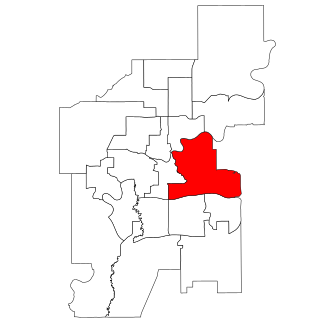
Edmonton Strathcona is a federal electoral district in Alberta, Canada, that has been represented in the House of Commons of Canada since 1953. It spans the south-central part of the city of Edmonton. In the periods 2008–2015 and 2019–2021, during the 40th, 41st, and 43rd Canadian Parliaments, Edmonton Strathcona was the only federal riding in Alberta not represented by the Conservative Party.

Strathcona was a provincial electoral district in Alberta, Canada, mandated to return a single member to the Legislative Assembly of Alberta using the first past the post method of voting from 1905 to 1913 and again from 2004 to 2012.
Edmonton-Gold Bar is a provincial electoral district, in Alberta, Canada. The district is one of 87 in the province mandated to return a single member to the Legislative Assembly of Alberta using the first past the post method of voting.

The North Saskatchewan River is a glacier-fed river that flows from the Canadian Rockies continental divide east to central Saskatchewan, where it joins with the South Saskatchewan River to make up the Saskatchewan River. Its water flows eventually into the Hudson Bay.
Strathcona was a city in Alberta, Canada on the south side of the North Saskatchewan River. Originally founded in 1891, it amalgamated with the City of Edmonton in 1912.

Cloverdale is a river valley neighbourhood in Edmonton, Alberta, Canada located on the south side of the North Saskatchewan River. It is located immediately across the river from the downtown core and the river valley neighbourhood of Riverdale. Southside neighbourhoods overlooking Cloverdale include: Bonnie Doon, Strathearn, Holyrood, and Forest Heights. The southwest corner of the neighbourhood is bounded by Connor's Road, the approaches to the Low Level Bridge, and the mouth of the Mill Creek Ravine. The Low Level Bridge and James McDonald Bridge connect the neighbourhood to the north side, while Scona Road provides access to Old Strathcona.

Mill Creek Ravine is located in Edmonton, Alberta, Canada and is a part of the River Valley parks and trail system. It contains the last stretch of Mill Creek, before it flows into a culvert for its end run to the North Saskatchewan River. The ravine ends where the land opens onto the North Saskatchewan River valley near the west end of Cloverdale on the opposite bank from downtown.

Garneau is one of the oldest neighbourhoods in the city of Edmonton, Canada. Prior to 1912, it was part of the City of Strathcona. It is named after one of its first inhabitants, Laurent Garneau, a former Manitoba Métis rebel and Hudson's Bay Company employee who with his wife and family settled there around 1874.
Strathcona is a residential neighbourhood in south central Edmonton, Alberta, Canada. It is a part of, and should not be confused with, Old Strathcona, although much of the Strathcona neighbourhood is in Old Strathcona. The neighbourhood overlooks both the North Saskatchewan River and the Mill Creek Ravine.

The North Saskatchewan River valley parks system, also known as the Ribbon of Green or the River Valley Parks, is a continuous collection of urban parks around the North Saskatchewan River valley in the Edmonton Metropolitan Region of Alberta, Canada. The park system encompasses over 7,300 hectares of parkland, making it the largest contiguous area of urban parkland in the country. The park system is made up of over 30 provincial and municipal parks situated around the river from Devon to Fort Saskatchewan, with trails connecting most of the parks together.
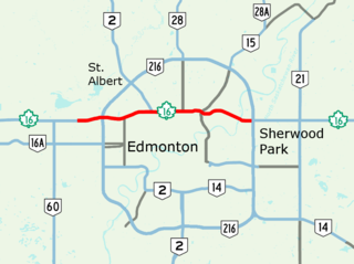
97/98/101 Avenue and Baseline Road is a major arterial road in central Edmonton and north Sherwood Park, Alberta. It connects Downtown Edmonton with the mature residential neighborhoods on the city's eastern edge, as well as Refinery Row and Sherwood Park.
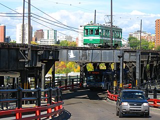
The High Level Bridge Streetcar is a historic streetcar ride over the High Level Bridge in Edmonton, Alberta. It travels from the Strathcona Streetcar Barn & Museum, just north of the Strathcona Farmers Market, in Old Strathcona, to Jasper Plaza south of Jasper Avenue, between 109 Street and 110 Street, in downtown, with three intermediate stops. It operates between the Victoria Day weekend in May, and Thanksgiving weekend in October. It is operated by the Edmonton Radial Railway Society, which operates five more streetcars on a second line in the river valley at Fort Edmonton Park.
Yellowhead Trail is a 24.6-kilometre (15.3 mi) expressway segment of the Yellowhead Highway in northern Edmonton, Alberta, Canada. It carries a significant amount of truck traffic to and from the industrial areas of north Edmonton and serves as a key commuter route for the bedroom communities of Stony Plain, Spruce Grove, and Sherwood Park, carrying nearly 80,000 vehicles per weekday in 2015. A suburban bypass of the route was completed when the northeast leg of Anthony Henday Drive (Highway 216) opened in late 2016, providing an alternate route through north Edmonton.
Walterdale is a former industrial and residential neighbourhood in Edmonton, Alberta, Canada within the North Saskatchewan River valley. It is located on the south shore of the river in an area now occupied by Kinsmen Park within a river valley neighbourhood named River Valley Walterdale.
Horsehills Creek is a creek that flows in the far northeastern corridor of the city of Edmonton, Alberta, Canada. The creek is a minor tributary to the North Saskatchewan River and is surrounded by agricultural fields and native vegetation. The City of Edmonton considers Horsehills Creek a designated protected site, because of the flora and fauna located in patches of forest and wetlands.
Fulton Creek is a minor tributary which flows into the North Saskatchewan River. Fulton Creek originates within The Meadows area of Edmonton, Alberta. As with other urban Edmonton waterways, with long stretches running through underground culverts, and water volume managed by other urban land uses and for erosion control, Fulton Creek has been labeled a lost creek.
Calgary Trail and Gateway Boulevard are a pair of major arterial roadways in Edmonton, Alberta. Gateway Boulevard carries northbound traffic while Calgary Trail carries southbound traffic. From south of 31 Avenue, they form a two-way freeway separated by a median; for this portion, the roadway maintains the separate names for northbound and southbound traffic. Near 31 Avenue, Calgary Trail and Gateway Boulevard separate and become parallel one-way arterial roadways to Saskatchewan Drive, at the edge of the North Saskatchewan River valley. Designated as part of Highway 2 south of Whitemud Drive, it is Edmonton's main southern entrance and is both a major commuter route, connecting to the Edmonton International Airport and Leduc, as well as a regional connection to Red Deer and Calgary.
