
Murrayfield is an area to the west of Edinburgh city centre in Scotland. It is to the east of Corstorphine and north of Balgreen, Saughtonhall and Roseburn. The A8 road runs east–west through the south of the area. Murrayfield is often considered to include the smaller neighbouring areas of Ravelston and Roseburn.
Edinburgh West is a burgh constituency of the House of Commons of the Parliament of the United Kingdom, first contested at the 1885 general election.

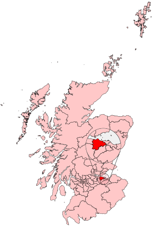
Edinburgh West was a constituency of the Scottish Parliament (Holyrood) from 1999 until 2011. It elected one Member of the Scottish Parliament (MSP) by the plurality method of election. It was also one of nine constituencies in the Lothians electoral region, which elected seven additional members, in addition to nine constituency MSPs, to produce a form of proportional representation for the region as a whole.
Corstorphine is an area of the Scottish capital city of Edinburgh. Formerly a separate village and parish to the west of Edinburgh, it is now a suburb of the city, having been formally incorporated into it in 1920.

Stewart's Melville College (SMC) is a private day and boarding school in Edinburgh, Scotland. Classes are all boys in the 1st to 5th years and co-educational in Sixth (final) year. It has a roll of about 750 pupils.

Balgreen is a suburb of Edinburgh, located approximately two miles west of the city centre, most commonly known for its primary school, Balgreen Primary. It is located to the west of Murrayfield and Saughtonhall, to the east of Corstorphine, and to the north of Gorgie. It is bound to the north by Corstorphine Hill, to the west by Carrick Knowe Golf Course, and roughly to the east by Water of Leith.

South Gyle is an area of Edinburgh, Scotland, lying on the western edge of the city and to the south and west of an area of former marshland once known as the Gogarloch, on the edge of Corstorphine. Most of the buildings in the area are of recent origin, dating from the later 1980s, 1990s, and early 21st century, with the exception of some farm workers' cottages and an early 1970s council estate abutting South Gyle railway station.

Corstorphine Hill is a low ridge-shaped hill rising above the western suburbs of Edinburgh, Scotland. Although there has been residential and commercial development on its lower slopes, especially in the south and west, most of the hill is occupied by a local nature reserve, consisting of extensive broadleaf woodland, accessible to the public.

Craigleith is an area of west Edinburgh, Scotland. Its name comes from various forms of Craig of Inverleith, or rock or hill of Inverleith. The area lies between Ravelston Dykes, to Crewe Toll and the Ferry Road, and Comely Bank on the east. Queensferry Road and Craigleith Road both pass through here. There are also a number of private schools in the area such as Stewart's Melville College and The Mary Erskine School.
Drumbrae or Drum Brae is the name of a suburb of west Edinburgh, Scotland generally considered to be part of the neighbouring larger areas of Corstorphine and Clermiston. This is a commuter settlement as many people who live in the area travel to the centre of town to attend work.
Cammo is a northwestern suburb of Edinburgh, the capital of Scotland. It is south of A90, at the edge of the city, approximately 6 miles from the city centre.

Roseburn is a suburb of Edinburgh, the capital of Scotland.

Burghmuirhead is an area of Edinburgh, Scotland.
Hunter's Tryst is the name of a long-established inn in Edinburgh, Scotland; it has lent its name to the surrounding area, near Fairmilehead.

Sir Godfrey Hilton Thomson FRSE DCL was an English educational psychologist known as a critical pioneer in intelligence research.
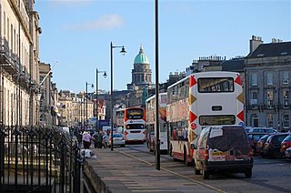
The West End is an affluent district of Edinburgh, Scotland, which along with the rest of the New Town and Old Town forms central Edinburgh, and Edinburgh's UNESCO World Heritage Site. The area boasts several of the city's hotels, restaurants, independent shops, offices and arts venues, including the Edinburgh Filmhouse, Edinburgh International Conference Centre and the Caledonian Hotel. The area also hosts art festivals and crafts fairs.

Corstorphine/Murrayfield is one of the seventeen wards used to elect members of the City of Edinburgh Council. Established in 2007 along with the other wards, it currently elects three Councillors.
The Inverleith Sports Ground is a rugby union stadium in Inverleith, Edinburgh, Scotland which is the home ground of amateur club Stewart's Melville RFC and was the home ground of the Scotland national rugby union team between 1899 and 1925.

Saughtonhall is a residential neighbourhood in the west of Edinburgh, Scotland, bordering Balgreen directly to the south and south-west, Murrayfield to the north, Carrick Knowe golf course to the west, and sports facilities on the opposite bank of the Water of Leith and its walkway to the east, connected by several footbridges which now also incorporate flooding defences. It is within the Corstorphine/Murrayfield ward under the City of Edinburgh Council.

