
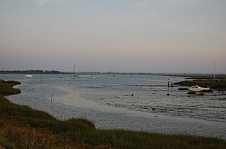
Mersea Island is an island in Essex, England, in the Blackwater and Colne estuaries to the south-east of Colchester. Its name comes from the Old English word meresig, meaning "island of the pool" and thus is tautological. The island is split into two main areas, West Mersea and East Mersea, and connected to the mainland by the Strood, a causeway that can flood at high tide.

The Swale is a tidal channel of the Thames estuary that separates the Isle of Sheppey from the rest of Kent. On its banks is a 6,509.4-hectare (16,085-acre) biological Site of Special Scientific Interest which stretches from Sittingbourne to Whitstable in Kent. It is also a Ramsar internationally important wetland site and a Special Protection Area under the European Union Directive on the Conservation of Wild Birds. Parts of it are a Nature Conservation Review site, Grade I, National Nature Reserves, a Kent Wildlife Trust nature reserve and a Local Nature Reserve.

Two Tree Island is a small island lying north-east of Canvey Island and south-west of Leigh-on-Sea in Essex, England. It covers 257 hectares and is connected to the mainland at Leigh by a single span bridge.
The Blackwater Estuary is the estuary of the River Blackwater between Maldon and West Mersea in Essex. It is a 5,538 hectare biological Site of Special Scientific Interest (SSSI). An area of 4,395 hectares is also designated a Ramsar Wetland of International Importance, and a Special Protection Area 1,099 hectares is a National Nature Reserve. Tollesbury Wick and part of Abbotts Hall Farm, both nature reserve managed by the Essex Wildlife Trust, are in the SSSI.

Scolt Head Island is an offshore barrier island between Brancaster and Wells-next-the-Sea in north Norfolk. It is in the parish of Burnham Norton and is accessed by a seasonal ferry from the village of Overy Staithe. The shingle and sand island appears to have originated from a former spit extending from the coast, and longshore drift means that it is slowly moving to the west and inshore.

Oare Marshes is a 71.4-hectare (176-acre) Local Nature Reserve north of Faversham in Kent. It is owned and managed by Kent Wildlife Trust. It is part of The Swale Nature Conservation Review site, Grade I, National Nature Reserve, Ramsar internationally important wetland site, Special Protection Area under the European Union Directive on the Conservation of Wild Birds, and Site of Special Scientific Interest.

Colne Estuary is a 2915 hectare biological and geological Site of Special Scientific Interest near Brightlingsea in Essex. It is also a Nature Conservation Review site, a National Nature Reserve, a Ramsar wetland site of international importance, a Special Protection Area, a Special Area of Conservation, and a Geological Conservation Review site. Three areas in the site are managed by the Essex Wildlife Trust, Colne Point, Fingringhoe Wick and Howlands Marsh.

Cley Marshes is a 176-hectare (430-acre) nature reserve on the North Sea coast of England just outside the village of Cley next the Sea, Norfolk. A reserve since 1926, it is the oldest of the reserves belonging to the Norfolk Wildlife Trust (NWT), which is itself the oldest county Wildlife Trust in the United Kingdom. Cley Marshes protects an area of reed beds, freshwater marsh, pools and wet meadows and is part of the North Norfolk Coast Site of Special Scientific Interest (SSSI), Special Area of Conservation (SAC), Special Protection Area (SPA), and Ramsar Site due to the large numbers of birds it attracts.

Beddmanarch–Cymyran is a site of special scientific interest (SSSI) on the Welsh island of Anglesey extending to just over 900 hectares, and centred on the Cymyran Strait. It was first notified in 1961 for its coastal botanical and ornithological interest. The site is also a marine protected area as it includes intertidal areas and contains marine components.
Thurrock Thameside Nature Park is an Essex Wildlife Trust nature reserve located on top of the former Mucking Marshes Landfill in Thurrock, England which will eventually cover 845 acres (342 ha). It is next to the River Thames and provides good bird and ship watching. The Cory Environmental Trust Visitor Centre is located at the preserve and provides a rooftop viewing platform.
Benfleet and Southend Marshes is an 8.1-square-mile (21 km2) Site of Special Scientific Interest (SSSI) in Essex. It consists of mudflats, salt marshes, scrub and wild grassland, and includes the Southend-on-Sea foreshore. It has been so recognised for its biological value, rather than geological. A definition five percent larger forms the Benfleet and Southend Marshes Ramsar site and Special Protection Area. In the centre-west, more than ten percent of the Site is the Leigh National Nature Reserve (NNR), which has been appraised in detail in A Nature Conservation Review as a site of national importance. The SSSI and NNR include the eastern half of Two Tree Island, in Leigh on Sea which is managed by the Essex Wildlife Trust. A narrow majority of the Site is the Southend on Sea Foreshore Local Nature Reserve.

The Crouch and Roach Estuaries are a 1729 hectare biological Site of Special Scientific Interest (SSSI) at the mouth of the Crouch and Roach rivers in Essex. The Crouch part of the SSSI stretches from near Battlesbridge to Foulness Island, and the Roach from Rochford to the junction with the Crouch. Part of the site is in the Mid-Essex Coast Special Protection Area under the EC Directive on the Conservation of Wild Birds, and a Ramsar wetland site of international importance. It is also part of the Essex Estuaries Special Area of Conservation. An area of 65 hectares is managed by the Essex Wildlife Trust as the Lion Creek and Lower Raypits nature reserve and 8 hectares at Woodham Fen, both of which are managed by the Essex Wildlife Trust. A small area is also a geological SSSI, The Cliff, Burnham-on-Crouch.

Foulness SSSI is a 10,702 hectare biological Site of Special Scientific Interest covering the shoreline between Southend-on-Sea and the Crouch estuary in Essex.

Hamford Water is a 2,185.8-hectare (5,401-acre) biological Site of Special Scientific Interest between Walton-on-the-Naze and Harwich in Essex. The site is a tidal inlet which has marsh grasslands, creeks, mud and sand flats, salt marshes, islands and beaches. It is described by Natural England as "of international importance for breeding little terns and wintering dark-bellied brent geese, wildfowl and waders, and of national importance for many other bird species." Rare plants include hog's fennel and slender hare's-ear. The main invertebrates are worms and thin-shelled molluscs. The largest island, Horsey Island, can be reached on foot at low tide across The Wade from Kirby-le-Soken.

Bradwell Shell Bank is a nature reserve on the coast of the Dengie Peninsula near Bradwell-on-Sea in Essex. It is managed by the Essex Wildlife Trust. It is part of the Dengie Site of Special Scientific Interest, Special Protection Area and Ramsar site, and the Essex Estuaries Special Area of Conservation. It is also part of the Blackwater Flats and Marshes, a Grade I site in the Nature Conservation Review.

Colne Point is a 276.4-hectare (683-acre) nature reserve south-west of St Osyth in Essex. It is managed by the Essex Wildlife Trust. It is part of the Colne Estuary Site of Special Scientific Interest, national nature reserve, Ramsar site, Nature Conservation Review site and Special Protection Area. It is also part of the Essex Estuaries Special Area of Conservation.

Howlands Marsh is a 29.9-hectare (74-acre) nature reserve north-east of St Osyth in Essex. It is managed by the Essex Wildlife Trust. It is part of the Colne Estuary Site of Special Scientific Interest Special Protection Area and Ramsar site, and the Blackwater Flats and Marshes Nature Conservation Review site.

Skipper's Island is a 94.3-hectare (233-acre) nature reserve north of Kirby-le-Soken in Essex, England. It is owned and managed by the Essex Wildlife Trust.

South Thames Estuary and Marshes is a 5,289-hectare (13,070-acre) biological Site of Special Scientific Interest which stretches between Gravesend and the mouth of the River Medway in Kent. Part of it is a Nature Conservation Review site, Grade I, and part is a Royal Society for the Protection of Birds nature reserve. It is part of the Thames Estuary and Marshes Ramsar internationally important wetland site and Special Protection Area under the European Union Directive on the Conservation of Wild Birds.
Milford Haven Waterway, is a Site of Special Scientific Interest (SSSI) on Milford Haven Waterway in Pembrokeshire, South Wales, designated since 2002. The site is protected for a wide range of reasons, including its geology, marine environment and ecosystems, and to protect a diversity of flora and fauna.

