
Bittern is a town on the Mornington Peninsula in Melbourne, Victoria, Australia, 61 km (38 mi) south-east of Melbourne's Central Business District, located within the Shire of Mornington Peninsula local government area. Bittern recorded a population of 4,276 at the 2021 census.

Merricks is a town in the south-eastern extremity of the Mornington Peninsula in Melbourne, Victoria, Australia, approximately 65 km (40 mi) south-east of Melbourne's Central Business District, located within the Shire of Mornington Peninsula local government area. Merricks recorded a population of 184 at the 2021 census.

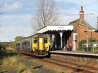
Bittern railway station is located on the Stony Point line in Victoria, Australia. It serves the town of Bittern, and it opened on 17 December 1889.

The Stony Point line is a greater-metropolitan commuter railway line in the city of Melbourne, Victoria, Australia. Operated by Metro Trains Melbourne, it is the city's only diesel service on the metropolitan network and the tenth longest line at 31 kilometres (19 mi). The line acts as an extension of the Frankston line with services running from Frankston station to the small town of Stony Point in the south-east, serving 10 stations via Leawarra, Baxter, Hastings, and Bittern. The line operates for approximately ~13 hours a day with no 24 hour service available on Friday and Saturday nights—unlike other lines on the metropolitan network. Headways of 90 to 120 minutes are operated throughout the day due to limited patronage and infrastructure constraints. Trains on the Stony Point line run as two one-car formations of V/Line Sprinters.

The Bittern Line is a railway branch line in Norfolk, England, that links Norwich to Sheringham. It passes through the Broads on its route to an Area of Outstanding Natural Beauty on the north Norfolk coast. It is named after the bittern, a rare bird found in the reedy wetlands of Norfolk.

4464Bittern is a London and North Eastern Railway (LNER) Class A4 steam locomotive. Built for the LNER and completed on 18 December 1937 at Doncaster Works as works number 1866, it received number 4464. After that it was renumbered 19 on 16 August 1946 under the LNER 1946 renumbering scheme, and finally 60019 by British Railways on 10 October 1948, after nationalisation. Of the 35 strong class, it is one of six to survive into preservation but it is one of only two currently scheduled to be certified for mainline use.
Worstead railway station is on the Bittern Line in Norfolk, England, serving the villages of Worstead and Sloley. It is 13 miles 12 chains (21.2 km) down the line from Norwich and is situated between Hoveton & Wroxham to the south and North Walsham to the north.

Hoveton & Wroxham railway station is on the Bittern Line in Norfolk, England, serving the village of Hoveton and the adjacent village of Wroxham. It is 8 miles 61 chains (14.1 km) down the line from Norwich and is situated between Salhouse and Worstead.

Salhouse railway station is on the Bittern Line in Norfolk, England, serving the village of Salhouse. It is the next station along the line from Norwich, 5 miles 74 chains (9.5 km) from that terminus; the following station is Hoveton & Wroxham.

North Walsham railway station is on the Bittern Line in Norfolk, England, serving the town of North Walsham. It is 16 miles (26 km) down the line from Norwich, between Worstead to the south and Gunton to the north.
The Norfolk and Suffolk Joint Railway (NSJR) was a British joint railway company.

Gunton railway station on the Bittern Line in Norfolk, England, serves the villages of Lower Street, Thorpe Market and Southrepps. It is 19 miles 63 chains (31.8 km) from Norwich, between North Walsham to the south and Roughton Road to the north.

Roughton Road railway station is on the Bittern Line in Norfolk, England, on the outskirts of the town of Cromer. It takes its name from the street on which it is located, and is several miles north of the village of Roughton. It is 24 miles 1 chain (38.6 km) down the line from Norwich and is situated between Gunton and Cromer stations.

West Runton railway station is on the Bittern Line in Norfolk, England, serving the village of West Runton. It is 28 miles 55 chains (46.2 km) down the line from Norwich and is situated between Cromer and Sheringham, the northern terminus.
Red Hill railway station was the terminus of the Red Hill railway line. The line was opened in 1921 and was one of the more short-lived branch lines on the Victorian Railways, closing in 1953, along with a few other smaller branch lines on the railways system. For a few years after the closure of the line, railmotors continued to run as far as Balnarring, to cater for the Balnarring picnic races and the Lord Somers Camp, as well as an Australian Railway Historical Society tour in 1956.
Merricks railway station was located on the Red Hill railway line. The line was opened in 1921 and was one of the more short lived branch lines on the Victorian Railways closing in 1952 with many other smaller branch lines in the railways system. The Merricks station grounds are now part of an equestrian facility. Part of the railway alignment between Red Hill and Merricks stations has also been converted into an equestrian and walking trail with the remaining majority of the line now located on private properties.
Balnarring railway station was located on the Red Hill railway line. The line was opened in 1921 and was one of the more short-lived branch lines on the Victorian Railways closing in 1953 along with a few other smaller branch lines in the railways system. Following official closure of the line, trains (railmotors) continued to run as far as Balnarring to cater for the Balnarring picnic races, Lord Somers camp and a Railway Historical Society tour in 1956. Part of the railway alignment between Red Hill and Merricks stations has been converted into an equestrian trail with the remaining majority of the line now located on private properties. The station is located in private property with almost no remains of the platform left.
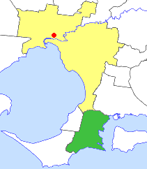
The Shire of Hastings was a local government area about 60 kilometres (37 mi) south-southeast of Melbourne, the state capital of Victoria, Australia, encompassing the eastern extremity of the Mornington Peninsula. The shire covered an area of 304.6 square kilometres (117.6 sq mi), and existed from 1960 until 1994.
Tunstead is a village and a civil parish in the English county of Norfolk. The village is 10.7 miles north north east of the city of Norwich, 15 miles south south east of Cromer and 129 miles north east of London. Tunstead is 2.5 miles north of the settlements of Wroxham and Hoveton.