Outer Circle railway line

Last updated

Outer Circle
Overview
StatusClosed line – Outer Circle (Anniversary) Trail, operational with passenger services from Riversdale to Alamein
Owner
Locale Melbourne, Victoria, Australia
Termini
Continues from Hurstbridge
Continues as Bairnsdale/Traralgon, Cranbourne & Pakenham
Connecting lines Alamein, Bairnsdale/Traralgon, Belgrave, Cranbourne, Glen Waverley, Hurstbridge, Lilydale & Pakenham lines
Stations
  • 9 current stations
  • 6 former stations
Service
ServicesAlamein
History
Commenced24 March 1890 (1890-03-24)
Opened
  • Darling to Oakleigh on 24 March 1890 (1890-03-24)
  • Camberwell to Waverley Road on 30 May 1890 (1890-05-30)
  • Fairfield to Riversdale on 24 March 1891 (1891-03-24)
  • Shenley to Canterbury on 15 March 1892 (1892-03-15)
Completed15 March 1892 (1892-03-15)
ReopenSee Alamein line
Closed
  • Fairfield to Riversdale on 12 April 1893 (1893-04-12)
  • Shenley to Canterbury on 12 April 1893 (1893-04-12)
  • Ashburton to Oakleigh on 9 December 1895 (1895-12-09)
  • Darling to Waverley Road on 9 December 1895 (1895-12-09)
  • Camberwell to Ashburton on 1 May 1897 (1897-05-01)
Technical
Line length25.275 km (15.705 mi)
Number of tracks Single track
Track gauge 1,600 mm (5 ft 3 in)
Route map

Contents

km
BSicon CONTg.svg
Arrow Blue Up 001.svg
BSicon HST.svg
0.0
Fairfield
Victoria bus logo.svg
BSicon xABZgl.svg
BSicon CONTfq.svg
Arrow Blue Up 001.svg
BSicon exHST.svg
Fulham Grange
BSicon exBUE.svg
BSicon RAq.svg
BSicon exABZgl.svg
BSicon exKBSTeq.svg
APM Siding
(not original)
BSicon exhKRZWae.svg
BSicon exHST.svg
Willsmere
BSicon exSKRZ-Au.svg
Australian state route 36.svgHigh Street
BSicon exHST.svg
East Kew
BSicon exBUE.svg
BSicon RAq.svg
BSicon exHST.svg
Deepdene
BSicon exBUE.svg
BSicon RAq.svg
Australian state route 34.svgWhitehorse Road (Maroondah Highway)
BSicon expHST.svg
Roystead
(not original)
BSicon exHST.svg
Shenley
BSicon exSKRZ-Au.svg
BSicon exkABZg2.svg
Arrow Blue LowerRight 001.svg
BSicon CONTgq.svg
BSicon kABZq2.svg
BSicon exkSTRc1.svg
BSicon exTUNNEL1.svg
BSicon pHSTq.svg
BSicon kSTRc3.svg
BSicon ekABZq+4.svg
BSicon CONTfq.svg
East Camberwell
(not original)
|
BSicon xkABZg+4.svg
Arrow Blue UpperLeft 001.svg
BSicon HST.svg
Riversdale
Victoria bus logo.svg
BSicon BUE.svg
BSicon RAq.svg
Australian state route 20.svgRiversdale Road
BSicon pHST.svg
Willison
(not original)
BSicon pHST.svg
Hartwell
(not original)
BSicon SKRZ-Ao.svg
Australian state route 26.svgToorak Road (Burwood Highway)
BSicon HST.svg
Burwood
BSicon HST.svg
Ashburton
Victoria bus logo.svg
BSicon SKRZ-Au.svg
Australian state route 24.svgHigh Street
BSicon ENDExe.svg
Alamein
(not original)
BSicon exhKRZWae.svg
Gardiners Creek (Kooyongkoot Creek)
BSicon RBq.svg
BSicon exSTR.svg
BSicon CONTgq.svg
BSicon ekABZq2.svg
BSicon exkSTRc3.svg
BSicon xKRZ.svg
BSicon CONTfq.svg
Arrow Blue Left 001.svgArrow Blue Right 001.svg
BSicon exkABZg+4.svg
Arrow Blue UpperLeft 001.svg
BSicon exHST.svg
Waverley Road (closed)
BSicon exBUE.svg
BSicon RAq.svg
Australian national route 1.svgDandenong Road (Princes Highway)
BSicon CONTgq.svg
BSicon xABZg+r.svg
Arrow Blue Left 001.svg
BSicon pHST.svg
Hughesdale
(not original) Victoria bus logo.svg
BSicon exCONTgq.svg
BSicon eABZg+r.svg
Arrow Blue Left 001.svg
Rosstown Railway
to Elsternwick
(dismantled)
BSicon SKRZ-Au.svg
BSicon HST.svg
25.3
Oakleigh
Victoria bus logo.svg
BSicon CONTf.svg
Arrow Blue Down 001.svg
km

The Outer Circle Railway was opened in stages in 1890 and 1891, as a steam-era suburban railway line, in Melbourne, Australia. It traversed much of the modern City of Boroondara, including the suburbs of (from north to south) Kew East, Camberwell, Burwood, Ashburton, and Malvern East. At its longest, it ran from Fairfield station, on what is today the Hurstbridge line, to Oakleigh station, on the current Pakenham and Cranbourne lines.

History

The Outer Circle railway was first advocated in 1867, by a group known as the Upper Yarra Railway League, who suggested that the Gippsland Railway could be brought into Melbourne via the outer suburbs. However, the term itself was coined in 1873 by Engineer-in-Chief of the Victorian Railways, Thomas Higinbotham, who suggested an "outer circle route". [1] [2] [3] [4]

Construction of the Gippsland line was authorised in 1873, but the line, which was to be operated by the Victorian Railways, could not be brought into Melbourne by the direct route used today because the privately owned Melbourne and Hobson's Bay United Railway Company (M&HBUR) controlled the line from Flinders Street to South Yarra, and there was no connection between the privately run Flinders Street station and the Victorian Railways station at Spencer Street. [5] That problem was solved when the M&HBUR was purchased by the government in 1878, and the direct rail line from South Yarra to Oakleigh was opened the next year. [6]

Agitation for the Outer Circle line was then taken over by politicians and land speculators. [7] It was included in the 1882 Railway Construction Act, and was authorised by the 1884 Railway Construction Act, passed on 12 December 1884. [8] The act also authorised the construction of a viaduct connecting Flinders Street and Spencer Street stations. By 1885, two of the parliamentarians who had helped gain approval for the line, F.E. Beaver and James Munro, had purchased half the land adjoining the new railway. [9] [10]

Construction commenced in 1888 and was completed in 1891. The Outer Circle connected Camberwell station (on the modern Belgrave and Lilydale lines) with Oakleigh station to the south, via Riversdale on what is now the Alamein line. The northern section ran from Riversdale to Fairfield station (then called Fairfield Park).

There was also a branch line from the closed Waverley Road station (near the modern East Malvern station) to Darling and Burnley. That was the first section of what later became the Glen Waverley line, and was opened a few weeks before the Outer Circle.

When opened the line was 10.3 miles (16.6 km) in length, and had 11 stations, all provided with twin platforms and crossing loops. Provision was made for double track, and heavier-duty 75 pounds (34 kg) per yard rails were used. [11] Despite that, the line never carried Gippsland traffic, and the severe economic depression of the early 1890s meant that suburban development along the line ceased. [12]

Services

Diagram showing Melbourne's rail network, including former and planned lines Melbourne rail map with former lines and planned extensions.svg
Diagram showing Melbourne's rail network, including former and planned lines

The first section of the Outer Circle opened was on 24 March 1890, from Oakleigh to Waverley Road, and on to Burnley. It was followed by the line from Waverley Road to Camberwell on 24 March 1890, and the Riversdale to Fairfield Park section on 24 March 1891. [13] From this time the line was operated as three different passenger services: [14]

Lack of passengers led to service cuts, and the Riversdale to Fairfield Park section was closed completely from 12 April 1893, being replaced by a horse bus service. [15] The Oakleigh to Ashburton and Darling section closed on 9 December 1895, [15] [16] and the last section, from Camberwell to Ashburton, closed on 1 May 1897. [17] Camberwell to Ashburton was reopened 4 July 1898 [13] as the Ashburton line.

Station histories

StationOpened [18] Closed [18] AgeNotes [18]
Fairfield 8 May 1888 || || data-sort-value=49,553 | 135 years
  • Formerly Fairfield Park
Fulham Grange 24 March 1891 || 12 April 1893 || data-sort-value=750 | 24 months
Willsmere 24 March 1891 || 12 April 1893 || data-sort-value=750 | 24 months
East Kew 24 March 1891 || 12 April 1893 || data-sort-value=750 | 24 months
Deepdene 24 March 1891 || 12 April 1893 || data-sort-value=750 | 24 months
Shenley 24 March 1891 || 12 April 1893 || data-sort-value=750 | 24 months
Camberwell 3 April 1882 || || data-sort-value=51,780 | 141 years
Canterbury 1 December 1882 || || data-sort-value=51,538 | 141 years
Riversdale 30 May 1890 || 1 May 1897 || data-sort-value=2,528 | 6 years
Burwood 30 May 1890 || 1 May 1897 || data-sort-value=2,528 | 6 years
Ashburton 30 May 1890 || 1 May 1897 || data-sort-value=2,528 | 6 years
Darling 24 March 1890 || || data-sort-value=48,868 | 133 years
Waverley Road 24 March 1890 || 9 December 1895 || data-sort-value=2,086 | 5 years
  • Formerly Waverley
Oakleigh 8 October 1877 || || data-sort-value=53,418 | 146 years

Today

Remains of Fulham Grange station in 2007 Fulham-Grange.jpg
Remains of Fulham Grange station in 2007
Aerial photo showing the alignment of the former Outer Circle Line at its former junction with the Hurstbridge Line near Fulham Grange, Alphington. Former junction of Outer Circle Line and Hurstbridge Line at Fulham Grange, Alphington.jpg
Aerial photo showing the alignment of the former Outer Circle Line at its former junction with the Hurstbridge Line near Fulham Grange, Alphington.
Outer Circle Railway formation south of Alamein station in 2011. Note stanchions for overhead catenary, erected in 1948 to connect Alamein to the Glen Waverley Line. Outercircle2011.jpg
Outer Circle Railway formation south of Alamein station in 2011. Note stanchions for overhead catenary, erected in 1948 to connect Alamein to the Glen Waverley Line.

Today, the southern section of the line from Camberwell to Alamein is part of the Melbourne suburban railway network as the Alamein line. The northern section of the line, starting at East Camberwell, has been converted into the Outer Circle Trail, a walking and bicycle path. [19] All of the closed stations have since been demolished, as has the railway infrastructure of the line, but some road overbridges and underbridges remain. The rail bridge over the Yarra River was converted into a road bridge as part of the Chandler Highway sometime after 1919. [20] The track between Fairfield station and the northern bank of the Yarra River came into use from 1919 as the APM Siding, [20] serving a paper mill built on the site.

Proposals for re-opening the line are regularly canvassed online. [21]

Media

In 2014, a documentary, Melbourne's Forgotten Railway – The Outer Circle, [22] was produced by a Melbourne-based media production team, led by Ron Killeen and Andrew McColm. It documented the line and included "historians, an urban planning expert, as well as people who actually remember seeing and riding on the train". [23]

See also

Related Research Articles

<span class="mw-page-title-main">Glen Iris railway station</span> Railway station in Melbourne, Australia

Glen Iris railway station is a commuter railway station in Glen Iris, a suburb of Melbourne, Victoria, Australia. The station opened on 24 March 1890 as part of the branch line from Burnley to Waverley Road station. The station consists of one island platform accessed by a pedestrian underpass. There is one principal station building located the platform. The single-story building, constructed in 1975 as part of the station's rebuilding, acts as a shelter and has toilet facilities. The station is only partially accessible due to steep access ramps.

<span class="mw-page-title-main">Camberwell railway station, Melbourne</span> Railway station in Camberwell, Melbourne, Victoria, Australia

Camberwell railway station is a commuter railway station and the junction point for the Alamein, Belgrave and Lilydale lines, serving the eastern Melbourne suburb of Camberwell, Victoria, Australia. Camberwell is a premium status ground structure station featuring three platforms, with an island platforms and one side platform, connected by a ramp accessible overground concourse. The station opened on 3 April 1882.

<span class="mw-page-title-main">East Camberwell railway station</span> Railway station in Melbourne, Australia

East Camberwell railway station is located on the Lilydale and Belgrave lines in Victoria, Australia. It serves the eastern Melbourne suburb of Camberwell, and it opened on 14 May 1900.

<span class="mw-page-title-main">Darling railway station</span> Railway station in Melbourne, Australia

Darling railway station is a commuter railway station in Malvern East, a suburb of Melbourne, Australia. The station opened on 24 March 1890 as part of the branch line from Burnley to Waverley Road station. The station consists of two side platforms accessed by a pedestrian bridge. There are two principal station buildings with one located on each platform. These buildings are both single story and act as customer service, staff, and waiting room facilities. These buildings were provided in 1979 as part of the station rebuild. The station is fully accessible and comply with DDA accessibility guidelines.

<span class="mw-page-title-main">East Malvern railway station</span> Railway station in Melbourne, Australia

East Malvern railway station is a commuter railway station on the Glen Waverley line, serving Malvern East, a suburb of Melbourne, Victoria, Australia. The station, originally called Karnak, opened as Eastmalvern on 3 February 1929. It was renamed East Malvern on 29 February 1972.

<span class="mw-page-title-main">Riversdale railway station</span> Railway station in Melbourne, Australia

Riversdale railway station is located on the Alamein line in Victoria, Australia. It serves the eastern Melbourne suburb of Camberwell, and it opened on 30 May 1890.

<span class="mw-page-title-main">Willison railway station</span> Railway station in Melbourne, Australia

Willison railway station is located on the Alamein line in Victoria, Australia. It serves the eastern Melbourne suburb of Camberwell, and opened on 8 June 1908 as Golf Links. It was renamed Willison on 23 July 1936.

<span class="mw-page-title-main">Hartwell railway station</span> Railway station in Victoria, Australia

Hartwell railway station is located on the Alamein line in Victoria, Australia. It serves the eastern Melbourne suburb of Camberwell, and opened on 7 May 1906 as Hartwell Hill. It was renamed Hartwell on 1 August 1909.

<span class="mw-page-title-main">Burwood railway station, Melbourne</span> Railway station in Melbourne, Australia

Burwood railway station is located on the Alamein line in Victoria, Australia. It serves the eastern Melbourne suburb of Glen Iris, and opened on 30 May 1890 as Hartwell. It was renamed Burwood on 1 August 1909.

<span class="mw-page-title-main">Ashburton railway station, Melbourne</span> Railway station in Melbourne, Australia

Ashburton railway station is located on the Alamein line in Victoria, Australia. It serves the eastern Melbourne suburb of Ashburton, and opened on 30 May 1890 as Norwood. It was renamed Ashburton on 12 December of that year.

<span class="mw-page-title-main">Alamein railway station</span> Railway station in Ashburton, Melbourne, Victoria, Australia

Alamein railway station is the terminus of the suburban electrified Alamein line in Victoria, Australia. It serves the eastern Melbourne suburb of Ashburton, and it opened on 28 June 1948.

<span class="mw-page-title-main">Alamein line</span> Passenger rail service in metropolitan Melbourne, Victoria, Australia

The Alamein line is a commuter railway line in the city of Melbourne, Victoria, Australia. Operated by Metro Trains Melbourne, it is the city's second shortest metropolitan railway line at 14.9 kilometres (9.3 mi). The line runs from Flinders Street station in central Melbourne to Alamein station in the east, serving 18 stations via Burnley, Camberwell, Riversdale, and Ashburton. The line operates for approximately 19 hours a day with 24 hour service available on Friday and Saturday nights. During peak hours, headways of up to 15 minutes are operated with services every 10–30 minutes during off-peak hours. Trains on the Alamein line run with one or two three-car formations of X'Trapolis 100 trainsets.

Waverley Road was a station on the Outer Circle railway line, opened on 3 March 1890 as "Waverley" on the section between Burnley and Oakleigh stations, and was renamed on 23 June 1890. It became a junction on 30 May 1890 when the line from Camberwell opened, and was a Staff and Ticket station, being provided with a signal box of 28 levers. Two platforms were provided, with the junction of the two lines at the North (Camberwell) end, as was a goods siding located near the current East Malvern station in Malvern East, Victoria, Australia, in what is now the Malvern Urban Forest. The platform, the mound of which can still be seen, was located approximately 120 metres SSE of where the line crossed Waverley Road.

Deepdene was a railway station on the Outer Circle railway line, located in the suburb of Balwyn, Melbourne, Australia. Located between Abercrombie Street and Whitehorse Road, it was opened on 24 March 1891, along with the line though it, and was named after the adjacent Deepdene House.

<span class="mw-page-title-main">Chandler Highway</span>

The Chandler Highway is a short road in the inner eastern suburbs of Melbourne. It runs from Heidelberg Road in Alphington, crosses the Yarra River, then continues across the Eastern Freeway, then terminates at an intersection with Princess Street and Earl Street. Its total length is less than 2 kilometres, leading to the claim that it is "the shortest highway in the world". It was named after a prominent local businessman and politician A. E. Chandler, who was instrumental in pushing through the development of the Outer Circle railway.

<span class="mw-page-title-main">Outer Circle Trail</span>

The Outer Circle Trail, also known as the Anniversary Trail, is a shared use path for cyclists and pedestrians, which partly follows the Alamein Line through the inner eastern suburbs of Melbourne, Victoria, Australia.

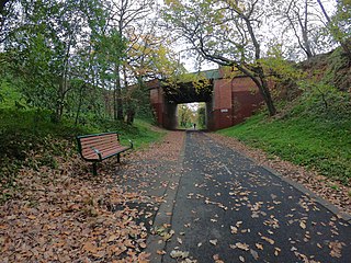
Roystead Railway Station was a railway station on the Outer Circle railway line, in the suburb of Canterbury, in Melbourne, Australia. It was opened on 14 May 1900, as "Stanley", to serve passengers on the so-called Deepdene Dasher shuttle service. This section of the line was in a cutting, and the station, with a single platform on the west side, was located south of a bridge, with red brick abutments and a green-painted iron superstructure, which took Mont Albert Road over the railway.

Shenley was a railway station on the Outer Circle railway line located in the suburb of Canterbury, Melbourne, Victoria, Australia. It was located immediately to the north of the Canterbury Road overbridge.

East Kew was a railway station on the Outer Circle railway line, located in the suburb of Kew, Melbourne, Victoria, Australia. The station opened with the line on 24 March 1891, and closed with the line on 12 April 1893. It was on the west side of Normanby Road, and was the site of a crossing loop, with a platform on each track. A goods siding was also provided at the Riversdale end.

<span class="mw-page-title-main">APM Siding</span> Former railway station in Victoria, Australia

The APM Siding was a 1.125-kilometre (0.7 mi) long private railway siding in the suburb of Alphington, Melbourne, Australia, that served the Australian Paper Manufacturers paper mill. The siding branched from Fairfield station, on the Hurstbridge line, and ran south-east, passing through the intersection of Chandler Highway, Grange and Heidelberg Roads, and entering the factory.

References

  1. Beardsell & Herbert 1979, p. 1.
  2. "THE OUTER-CIRCLE RAILWAY". The Argus (Melbourne) . No. 8, 530. Victoria, Australia. 14 October 1873. p. 6. Retrieved 22 June 2017 via National Library of Australia.
  3. "THE OUTER CIRCLE RAILWAY". Weekly Times . No. 217. Victoria, Australia. 1 November 1873. p. 7. Retrieved 22 June 2017 via National Library of Australia.
  4. "THE PROPOSED NEW SUBURBAN LINES". The Argus (Melbourne) . No. 11, 952. Victoria, Australia. 11 October 1884. p. 5. Retrieved 22 June 2017 via National Library of Australia.
  5. Beardsell & Herbert 1979, p. 6.
  6. Beardsell & Herbert 1979, p. 19.
  7. Beardsell & Herbert 1979, p. 4.
  8. Beardsell & Herbert 1979, p. 26.
  9. Beardsell & Herbert 1979, p. 27.
  10. "THE OUTER CIRCLE RAILWAY. CONTRACT FOR ITS CONSTRUCTION". The Age . No. 10314. Victoria, Australia. 13 March 1888. p. 5. Retrieved 22 June 2017 via National Library of Australia.
  11. Beardsell & Herbert 1979, p. 55.
  12. Beardsell & Herbert 1979, p. 56.
  13. 1 2 S.E. Dornan and R.G. Henderson (1979). Electric Railways of Victoria. Australian Electric Traction Society. p. 84. ISBN   0-909459-06-1.
  14. Beardsell & Herbert 1979, p. 50.
  15. 1 2 Beardsell & Herbert 1979, p. 59.
  16. "Victorian Railways. An unremuerative line closed". Evening News . No. 8062. New South Wales, Australia. 4 April 1893. p. 6. Retrieved 22 June 2017 via National Library of Australia.
  17. Beardsell & Herbert 1979, p. 60.
  18. 1 2 3 Anderson, Rick (2010). Stopping All Stations. Clunes, Victoria: Full Parallel Productions. ISBN   978-0646543635. OCLC   671303814.
  19. "Outer Circle Rail Trail – Trail Description". railtrails.org.au. Retrieved 12 March 2008.
  20. 1 2 S Cauchi (November 1994). "Closure of the Australian Paper Ltd siding at Fairfield". Newsrail. Vol. 22, no. 11. Australian Railway Historical Society (Victorian Division). pp. 328–331.
  21. "Hypothetical: The Outer Circle rebuilt?". Railpage. Retrieved 25 November 2021.
  22. Shack West (14 December 2014). Melbourne's Forgotten Railway – The Outer Circle (Motion Picture). Retrieved 21 October 2019 via Vimeo.
  23. Killeen, Ron (4 December 2014). "Melbourne's Forgotten Railway – documentary out now!" (PDF) (Press release). Melbourne, Victoria: Shack West. Retrieved 20 October 2019.

Sources