Dandenong railway station

Last updated

Dandenong
PTV commuter and regional rail station
Dandenong Station.jpg
North-west bound view from Platform 3 looking at station concourse, January 2013
General information
LocationRudduck Street,
Dandenong, Victoria 3175
City of Greater Dandenong
Australia
Coordinates 37°59′24″S145°12′35″E / 37.9900°S 145.2098°E / -37.9900; 145.2098
Owned by VicTrack
Operated by Metro Trains
Line(s)
Distance31.19 kilometres from
Southern Cross
Platforms3 (2 side, 1 island)
Tracks9
Train operators
Connections
Construction
Structure typeAt-grade
Parking300 spaces
Bicycle facilities12 racks
AccessibleNo — steep ramp
Other information
StatusOperational, premium station
Station codeDNG
Fare zone Myki Zone 2
Website Public Transport Victoria
History
Opened8 October 1877;146 years ago (1877-10-08)
Rebuilt1975
24 March 1995
ElectrifiedDecember 1922
(1500 V DC overhead)
Passengers
2005–20061,749,164 [1]
Preceding station Melbourne train logo.svg Metro Trains Following station
Yarraman Pakenham line Hallam
towards Pakenham
Cranbourne line Lynbrook
towards Cranbourne
Terminus Cranbourne line
Shuttle services
Future (from 2025)
Yarraman
towards Sunbury
Sunshine–Dandenong corridor
(under construction)
Hallam
towards East Pakenham
Lynbrook
towards Cranbourne
Preceding station Victoria train logo.svg V/Line Following station
Clayton Gippsland line Berwick
1 weekday peak service
towards Traralgon
Pakenham
towards Traralgon or Bairnsdale
Caulfield Gippsland line
Bairnsdale express
Pakenham
towards Bairnsdale
Former services
Preceding station Disused railways Following station
Line open  Orbost line   General Motors
Terminus  South Gippsland line   Lyndhurst
Track layout
BSicon MFADEg.svg
BSicon STR.svg
BSicon MFADEg.svg
BSicon STR.svg
BSicon STRg.svg
BSicon STRf.svg
BSicon ENDEa.svg
BSicon ENDEa.svg
BSicon STRc2.svg
BSicon ABZg3.svg
BSicon STR.svg
BSicon STR2.svg
BSicon STRc3.svg
BSicon STR.svg
BSicon STR+1.svg
BSicon STRc4.svg
BSicon STR.svg
BSicon STR.svg
BSicon ENDEa.svg
BSicon STRc1.svg
BSicon ABZ2+4g.svg
BSicon STRc3.svg
BSicon STR.svg
BSicon STR.svg
BSicon STR.svg
BSicon STR.svg
BSicon STRc1.svg
BSicon ABZg+4.svg
BSicon STR.svg
BSicon STR.svg
BSicon STR.svg
BSicon ABZg2.svg
BSicon STRc3.svg
BSicon STR.svg
BSicon STR.svg
BSicon ENDE@G.svg
BSicon STR.svg
BSicon STRc1.svg
BSicon STR.svg
BSicon ABZg+4.svg
BSicon STR.svg
BSicon STR.svg
BSicon STR.svg
BSicon STR.svg
BSicon STR.svg
BSicon STR.svg
BSicon STR.svg
BSicon STR.svg
BSicon STR.svg
BSicon KRWg+l.svg
BSicon KRWgr.svg
BSicon STRc2.svg
BSicon STR.svg
BSicon STR3.svg
BSicon STRc2 black.svg
BSicon STR.svg
BSicon STR3 black.svg
BSicon KRWgl.svg
BSicon STRc2.svg
BSicon KRWg+r.svg
BSicon ABZ3+1g.svg
BSicon STRc4.svg
BSicon STR+1 black.svg
BSicon STRc4 black.svg
BSicon STR.svg
BSicon STR.svg
BSicon ABZg+1.svg
BSicon STRc4.svg
BSicon STR black.svg
1
BSicon PSTR(L).svg
BSicon PSTR(R).svg
3
BSicon PSTR(L).svg
BSicon ENDE@F black.svg
BSicon PSTR(L).svg
2
BSicon PSTR(R).svg
BSicon PSTR(L).svg
BSicon STR.svg
BSicon KRWg+l.svg
BSicon KRWgr.svg
BSicon hSTRae(r).svg
BSicon STR.svg
BSicon hSTRae(l).svg
BSicon ABZg2.svg
BSicon STRc3.svg
BSicon ABZg2.svg
BSicon STRc3.svg
BSicon STR.svg
BSicon STRc1.svg
BSicon STR.svg
BSicon STRc1.svg
BSicon ABZg+4.svg
BSicon ABZg+4.svg
BSicon STR.svg
BSicon STR.svg
BSicon STR.svg
BSicon SKRZ-G2BUE.svg
Webster Street
(Removing by 2025)
BSicon STRc2.svg
BSicon STR.svg
BSicon ABZg3.svg
BSicon STR.svg
BSicon ABZg+1.svg
BSicon STRc4.svg
BSicon STR.svg
BSicon STR.svg
BSicon STR.svg
BSicon STRc2.svg
BSicon STR.svg
BSicon ABZg3.svg
BSicon STR.svg
BSicon ABZg+1.svg
BSicon STRc4.svg
BSicon STR.svg
BSicon STRc2.svg
BSicon STRc2.svg
BSicon STR3.svg
BSicon ABZg3.svg
BSicon STR.svg
BSicon MFADEgq.svg
BSicon STRq.svg
BSicon STRfq.svg
BSicon STRc2.svg
BSicon STRr+1.svg
BSicon STRc4.svg
BSicon STR3+1.svg
BSicon STRc4.svg
BSicon STR.svg
BSicon STR.svg
BSicon MFADEgq.svg
BSicon STRq.svg
BSicon STRgq.svg
BSicon STRr+1.svg
BSicon STRc4.svg
BSicon STRg.svg
BSicon STRf.svg
BSicon MFADEf.svg
BSicon STR.svg
BSicon MFADEf.svg
BSicon STR.svg
to Hallam

BSicon STRq.svg
BSicon exSTRq.svg
BSicon lELC.svg
BSicon STRq black.svg
BSicon exSTRq black.svg
BSicon exlELC.svg

Dandenong railway station is the junction for the Cranbourne and Pakenham lines in Victoria, Australia. It serves the south-eastern Melbourne suburb of the same name, and opened on 8 October 1877. [4]

Contents

A number of train stabling sidings are located near the station, including to the north of the station on either side of the railway line, as well as parallel to the platforms. A little-used goods yard was once located to the south of the station. [4]

The disused General Motors station was situated between Dandenong and Hallam.

History

Dandenong opened as one of the original stations on the Melbourne to Sale railway line. In 1892, the South Gippsland line opened from Dandenong. Like the suburb itself, the station name derives either from an Indigenous word believed to mean "lofty mountains", [5] or the Woiwurrung word "Tanjenong", which was the name of a local creek. [6]

In 1922, the line from Oakleigh to Dandenong was electrified. [4] In 1954, electrification was extended to Warragul, then onwards to Traralgon. [4] Trains beyond Dandenong were generally hauled by L class electric locomotives, and were principally used for passenger services and briquette traffic, using coal from the large open cut coal mines in the Latrobe Valley. In 1956, the line was duplicated to Narre Warren. [4]

In 1972, the down end of Platform 1 was extended. [7] On 19 January 1975, electrified suburban services were extended to Pakenham. [8] Occurring in that year, the station buildings were reconstructed. [9]

During 1994-1995, the station was again rebuilt, as part of the Cranbourne electrification project. [10] The rebuild included the demolition of the former Southern Aurora Hotel (completed in May 1993), [11] the removal of the former timber station building (completed in April 1994), [11] and filling-in the pedestrian underpass at the down end of the station. [11] On 24 March 1995, the rebuilt station was opened by the then Prime Minister Paul Keating. [12] [13] [14]

During the 2017/2018 financial year, Dandenong was the twelfth-busiest station on Melbourne's metropolitan network, with almost 2.2 million passenger movements. [15]

Facilities, platforms and services

Dandenong has one side platform and one island platform with two faces. Access to the platforms is provided by stairs and lifts from an overhead concourse. The side platform (Platform 3) has a kiosk and an enclosed waiting room, containing a customer service window and toilets.

Dandenong is served by Cranbourne and Pakenham line trains, [16] [17] and by V/Line Traralgon and Bairnsdale trains. [18] [19]

Platform 1:

Platform 2:

Platform 3:

Up until mid-late 2019, the unique configuration of the tracks at both ends of the station allowed trains to depart from any platform, in any direction. Since then, Pakenham bound services can no longer depart from Platform 1.

Future services:
In addition to the current services, the PTV Network Development Plan proposes linking the Cranbourne and Pakenham lines to both the Sunbury line and the proposed Melbourne Airport rail link via the Metro Tunnel. [20]

Cranbourne Transit operates three bus routes to and from Dandenong station, under contract to Public Transport Victoria:

Kinetic Melbourne operates one SmartBus route via Dandenong station, under contract to Public Transport Victoria:

Ventura Bus Lines operates twenty routes via Dandenong station, under contract to Public Transport Victoria:

V/Line operates two coach services to and from Dandenong station:

Related Research Articles

<span class="mw-page-title-main">Springvale, Victoria</span> Suburb of Melbourne, Victoria, Australia

Springvale is a suburb in Melbourne, Victoria, Australia, 22 km (14 mi) south-east of Melbourne's Central Business District, located within the City of Greater Dandenong local government area. Springvale recorded a population of 22,174 at the 2021 census.

<span class="mw-page-title-main">Box Hill railway station, Melbourne</span> Railway station in Box Hill, Melbourne, Victoria, Australia

Box Hill railway station is located on the Lilydale and Belgrave lines in Victoria, Australia. It serves the eastern Melbourne suburb of Box Hill, and opened on 1 December 1882.

<span class="mw-page-title-main">Malvern railway station, Melbourne</span> Railway station in Melbourne, Australia

Malvern railway station is a commuter railway station that is part of the Melbourne railway network in Victoria, Australia. The station is located on the southern border of Malvern, a suburb of Melbourne, and was opened on 7 May 1879. The station complex consists of an island platform and two side platforms all accessed by a pedestrian bridge. There are two red brick Edwardian-era station buildings, constructed in 1914 as ticketing and staff offices. The entire complex is listed on the Victorian Heritage Register because of its architectural significance and its role in the development of Malvern as a significant metropolitan centre. The station is only partially accessible because of multiple steep access ramps.

<span class="mw-page-title-main">Caulfield railway station</span> Railway station in Melbourne, Australia

Caulfield railway station is a commuter railway station on the northern boundary of Caulfield East, a suburb of Melbourne, Victoria, Australia. Opened in 1879 and rebuilt from 1913 to 1914, the station complex is listed on the Victorian Heritage Register and is noted as an example of Federation Free Style architecture. It is named after the nearby suburb of Caulfield, located southwest of the station.

<span class="mw-page-title-main">Carnegie railway station</span> Railway station in Melbourne, Australia

Carnegie railway station is a commuter railway station located in the suburb of Carnegie, in the southeastern suburbs of Melbourne, Victoria, Australia. The station originally opened in 1879 as Rosstown. The station received its current name in 1909 alongside the renaming of the suburb. The station consists of a single island platform connected to the station concourse on Koornang Road via escalators, lifts and a staircase.

<span class="mw-page-title-main">Murrumbeena railway station</span> Railway station in Melbourne, Australia

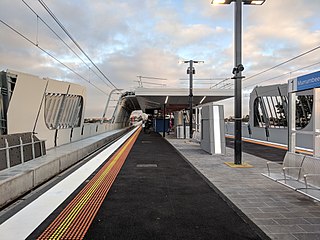
Murrumbeena railway station is located on the Pakenham and Cranbourne lines in Victoria, Australia. It serves the south-eastern Melbourne suburb of Murrumbeena, and it opened on 14 May 1879.

<span class="mw-page-title-main">Hughesdale railway station</span> Railway station in Melbourne, Australia

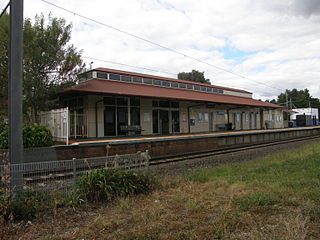
Hughesdale railway station is located on the Pakenham and Cranbourne lines in Victoria, Australia. It serves the south-eastern Melbourne suburb of Murrumbeena, and opened on 28 February 1925.

<span class="mw-page-title-main">Oakleigh railway station</span> Railway station in Melbourne, Australia

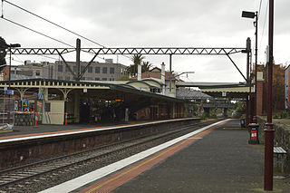
Oakleigh railway station is a commuter railway station in the suburb of Oakleigh in the south-east of Melbourne, Victoria, Australia. The station opened in 1877 as the up end of the Gippsland line, with the station being electrified in 1922. The station consists of two sides that are connected to each other via the adjacent roads, and both platforms are connected to each other via a pedestrian subway.

<span class="mw-page-title-main">Huntingdale railway station</span> Railway station in Melbourne, Australia

Huntingdale railway station is a commuter railway station located adjacent to the suburbs of Oakleigh and Huntingdale located in the south east of Melbourne, Victoria in Australia. The station originally opened in 1927 as "East Oakleigh". It did not receive its current name until 1954. The station consists of a single island platform connected to both Railway Avenue and Haughton Road via a pedestrian subway.

<span class="mw-page-title-main">Clayton railway station, Melbourne</span> Railway station in Melbourne, Australia

Clayton railway station is a commuter railway station located in the suburb of Clayton, in the south-eastern suburbs of Melbourne, Victoria, Australia. The station originally opened in 1880 as "Clayton's Road". It did not receive its current name until 1890. The station consists of a single island platform connected to the station concourse on Clayton Road via escalators, lifts and a staircase. The station was previously at grade; however, in 2018, a new elevated station was rebuilt as part of the Level Crossing Removal Project.

<span class="mw-page-title-main">Westall railway station</span> Railway station in Melbourne, Australia

Westall railway station is located on the Pakenham and Cranbourne lines in Victoria, Australia. It serves the south-eastern Melbourne suburb of Clayton South, and opened on 6 February 1951.

<span class="mw-page-title-main">Springvale railway station</span> Railway station in Melbourne, Australia

Springvale railway station is located on the Pakenham and Cranbourne lines in Victoria, Australia. It serves the south-eastern Melbourne suburb of Springvale, and it opened on 1 September 1880 as Spring Vale. It was renamed Springvale on 29 February 1972.

<span class="mw-page-title-main">Noble Park railway station</span> Railway station in Melbourne, Australia

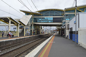
Noble Park railway station is located on the Cranbourne and Pakenham lines in Victoria, Australia. It serves the south-eastern Melbourne suburb of Noble Park, and opened on 3 February 1913.

<span class="mw-page-title-main">Yarraman railway station</span> Railway station in Melbourne, Australia

Yarraman railway station is a minor commuter railway station on the Cranbourne and Pakenham lines of the metropolitan railway network in Victoria, Australia, located about 27 km (17 mi) from the Melbourne CBD. It serves neighbourhoods between the south-eastern Melbourne suburbs of Noble Park and Dandenong, and is named after the nearby Yarraman Creek, a first-order tributary of the lower Dandenong Creek/Patterson River system.

<span class="mw-page-title-main">Hallam railway station</span> Railway station in Melbourne, Australia

Hallam railway station is located on the Pakenham line in Victoria, Australia. It serves the south-eastern Melbourne suburb of Hallam, and it opened on 1 December 1880 as Hallam's Road. It was renamed Hallam on 2 May 1904.

<span class="mw-page-title-main">Berwick railway station, Melbourne</span> Railway station in Melbourne, Australia

Berwick railway station is located on the Pakenham line in Victoria, Australia. It serves the south-eastern Melbourne suburb of Berwick, and it opened on 8 October 1877.

<span class="mw-page-title-main">Pakenham railway station</span> Railway station in Melbourne, Australia

Pakenham railway station is the terminus of the suburban electrified Pakenham line in Victoria, Australia. It serves the south-eastern Melbourne suburb of Pakenham, and it opened on 8 October 1877.

<span class="mw-page-title-main">Cranbourne railway station</span> Railway station in Melbourne, Australia

Cranbourne railway station is the terminus of the suburban electrified Cranbourne line in Victoria, Australia. It serves the south-eastern Melbourne suburb of Cranbourne, and opened on 1 October 1888.

<span class="mw-page-title-main">Glen Waverley railway station</span> Commuter railway station in Melbourne, Australia

Glen Waverley railway station is a commuter railway station located in the suburb of Glen Waverley in the south-east of Melbourne, Victoria, Australia. The station originally opened in 1930 as part of the line's extension from Eastmalvern. The station consists of a single island platform with two faces, that is connected to Kingsway via a ramp on the station's eastern end.

<span class="mw-page-title-main">Scotchmans Creek Trail</span>

The Scotchmans Creek Trail is a shared use path for cyclists and pedestrians, which follows Scotchmans Creek through the eastern suburbs of Melbourne, Victoria, Australia.

References

  1. 1 2 3 4 Estimated Annual Patronage by Network Segment Financial Year 2005–2006 to 2018–19 Department of Transport
  2. 1 2 3 4 5 6 7 8 9 10 11 12 Railway station and tram stop patronage in Victoria for 2008–2021 Philip Mallis
  3. 1 2 Annual metropolitan train station patronage (station entries) Data Vic
  4. 1 2 3 4 5 "Dandenong". vicsig.net. Retrieved 27 January 2023.
  5. "Dandenong". Victorian Places. Retrieved 27 January 2023.
  6. First, Jamie (7 January 2014). "The A-Z story of Melbourne's suburbs". Herald Sun . Retrieved 27 January 2023.
  7. "Way and Works". Divisional Diary . Australian Railway Historical Society. May 1972. p. 5.
  8. "Improved Suburban Services". Newsrail . Australian Railway Historical Society. February 1975. p. 33.
  9. Winter, Vincent Adams (1990). VR and VicRail: 1962–1983. p. 106. ISBN   0-9592069-3-0.
  10. Fiddian, Mark (1997). Trains, Tracks, Travellers. A history of the Victorian Railways. South Eastern Independent Newspapers. p. 154. ISBN   1-875475-12-5.
  11. 1 2 3 "Works". Newsrail. Australian Railway Historical Society. August 1994. p. 252.
  12. "Show of hands for a new rail service". The Age . 25 March 1995. p. 7.
  13. "Cranbourne Electrification Opened" Railway Digest , May 1995, page 16
  14. "Upgrading Eltham to a Premium Station". Newsrail. Australian Railway Historical Society. October 1997. pp. 303–315.
  15. Station Patronage Research Archived 23 May 2016 at the Wayback Machine Public Transport Victoria
  16. "Pakenham Line". Public Transport Victoria.
  17. "Cranbourne Line". Public Transport Victoria.
  18. Traralgon – Melbourne timetable Public Transport Victoria
  19. Bairnsdale – Melbourne timetable Public Transport Victoria
  20. "Network Development Plan Metropolitan Rail Overview" (PDF). Public Transport Victoria. December 2012. Archived (PDF) from the original on 19 September 2021. Retrieved 13 February 2023.
  21. "890 Dandenong Station – Lynbrook Station". Public Transport Victoria . Retrieved 30 April 2023.
  22. "892 Casey Central SC – Dandenong Station via Hampton Park SC". Public Transport Victoria. Retrieved 30 April 2023.
  23. "893 Cranbourne Park SC – Dandenong Station". Public Transport Victoria. Retrieved 30 April 2023.
  24. "901 Frankston - Melbourne Airport (SMARTBUS Service)". Public Transport Victoria.
  25. "800 Dandenong – Chadstone via Princes Highway & Oakleigh". Public Transport Victoria. Retrieved 30 April 2023.
  26. "802 Dandenong - Chadstone via Mulgrave & Oakleigh". Public Transport Victoria.
  27. "804 Dandenong - Chadstone via Wheelers Hill & Oakleigh". Public Transport Victoria.
  28. "811 Dandenong - Brighton via Heatherton Road & Springvale". Public Transport Victoria.
  29. "812 Dandenong - Brighton via Parkmore Shopping Centre". Public Transport Victoria.
  30. "813 Dandenong - Waverley Gardens SC". Public Transport Victoria.
  31. "814 Springvale South - Dandenong via Waverley Gardens Shopping Centre & Springvale". Public Transport Victoria.
  32. "828 Hampton – Berwick Station via Southland SC & Dandenong". Public Transport Victoria. Retrieved 30 April 2023.
  33. "843 Endeavour Hills – Dandenong Station via Daniel Solander Dr". Public Transport Victoria. Retrieved 30 April 2023.
  34. "844 Dandenong - Doveton via McCrae Street". Public Transport Victoria.
  35. "845 Endeavour Hills – Dandenong Station via Kennington Park Dr". Public Transport Victoria. Retrieved 30 April 2023.
  36. "848 Dandenong - Brandon Park Shopping Centre via Waverley Gardens Shopping Centre". Public Transport Victoria.
  37. "850 Dandenong - Glen Waverley via Mulgrave & Brandon Park". Public Transport Victoria.
  38. "857 Chelsea Railway Station – Dandenong Railway Station via Patterson Lakes". Public Transport Victoria. Retrieved 30 April 2023.
  39. "861 Endeavour Hills – Dandenong Station via Dandenong Hospital". Public Transport Victoria. Retrieved 30 April 2023.
  40. "862 Dandenong - Chadstone via North Dandenong & Oakleigh". Public Transport Victoria.
  41. "978 Clayton Station – Dandenong Station via Mulgrave". Public Transport Victoria. Retrieved 30 April 2023.
  42. "979 Clayton Station – Dandenong Station via Keysborough". Public Transport Victoria. Retrieved 30 April 2023.
  43. "981 Dandenong Station – Cranbourne via Berwick". Public Transport Victoria. Retrieved 30 April 2023.
  44. "982 Dandenong Station – Cranbourne via Endeavour Hills & Hampton Park". Public Transport Victoria. Retrieved 30 April 2023.
  45. 1 2 "Cowes and Inverloch – Melbourne via Dandenong & Koo Wee Rup". Public Transport Victoria. Retrieved 30 April 2023.