Related Research Articles

Glen Iris railway station is a commuter railway station in Glen Iris, a suburb of Melbourne, Victoria, Australia. The station opened on 24 March 1890 as part of the branch line from Burnley to Waverley Road station. The station consists of one island platform accessed by a pedestrian underpass. There is one principal station building located the platform. The single-story building, constructed in 1975 as part of the station's rebuilding, acts as a shelter and has toilet facilities. The station is only partially accessible due to steep access ramps.

Ashburton is an affluent suburb of Melbourne, Victoria, Australia, 12 km (7.5 mi) southeast of Melbourne's Central Business District, located within the City of Boroondara local government area. Ashburton recorded a population of 7,952 at the 2021 census.

Camberwell railway station is the junction for the Lilydale, Belgrave and Alamein lines in Victoria, Australia. It serves the eastern Melbourne suburb of Camberwell, and it opened on 3 April 1882.

East Camberwell railway station is located on the Lilydale and Belgrave lines in Victoria, Australia. It serves the eastern Melbourne suburb of Camberwell, and it opened on 14 May 1900.

Oakleigh railway station is a commuter railway station in the suburb of Oakleigh in the south-east of Melbourne, Victoria, Australia. The station opened in 1877 as the up end of the Gippsland line, with the station being electrified in 1922. The station consists of two sides that are connected to each other via the adjacent roads, and both platforms are connected to each other via a pedestrian subway.

Tooronga railway station is located on the Glen Waverley line in Victoria, Australia. It serves the eastern Melbourne suburb of Malvern, and opened on 24 March 1890.

Gardiner railway station is a commuter railway station in Glen Iris, a suburb of Melbourne, Victoria, Australia. The station opened on 24 March 1890, named after pastoralist John Gardiner, who had settled near the junction of the Yarra River and Gardiners Creek in 1836.

Darling railway station is a commuter railway station in Malvern East, a suburb of Melbourne, Australia. The station opened on 24 March 1890 as part of the branch line from Burnley to Waverley Road station. The station consists of two side platforms accessed by a pedestrian bridge. There are two principal station buildings with one located on each platform. These buildings are both single story and act as customer service, staff, and waiting room facilities. These buildings were provided in 1979 as part of the station rebuild. The station is fully accessible and comply with DDA accessibility guidelines.

East Malvern railway station is a commuter railway station on the Glen Waverley line, serving Malvern East, a suburb of Melbourne, Victoria, Australia. The station, originally called Karnak, opened as Eastmalvern on 3 February 1929. It was renamed East Malvern on 29 February 1972.

Riversdale railway station is located on the Alamein line in Victoria, Australia. It serves the eastern Melbourne suburb of Camberwell, and it opened on 30 May 1890.

Burwood railway station is located on the Alamein line in Victoria, Australia. It serves the eastern Melbourne suburb of Glen Iris, and opened on 30 May 1890 as Hartwell. It was renamed Burwood on 1 August 1909.

Ashburton railway station is located on the Alamein line in Victoria, Australia. It serves the eastern Melbourne suburb of Ashburton, and opened on 30 May 1890 as Norwood. It was renamed Ashburton on 12 December of that year.

Alamein railway station is the terminus of the suburban electrified Alamein line in Victoria, Australia. It serves the eastern Melbourne suburb of Ashburton, and it opened on 28 June 1948.
The Alamein line is a commuter railway line in the city of Melbourne, Victoria, Australia. Operated by Metro Trains Melbourne, it is the city's second shortest metropolitan railway line at 14.9 kilometres (9.3 mi). The line runs from Flinders Street station in central Melbourne to Alamein station in the east, serving 18 stations via Burnley, Camberwell, Riversdale, and Ashburton. The line operates for approximately 19 hours a day with 24 hour service available on Friday and Saturday nights. During peak hours, headways of up to 15 minutes are operated with services every 10–30 minutes during off-peak hours. Trains on the Alamein line run with one or two three-car formations of X'Trapolis 100 trainsets.
The Outer Circle Railway was opened in stages in 1890 and 1891, as a steam-era suburban railway line, in Melbourne, Australia. It traversed much of the modern City of Boroondara, including the suburbs of Kew East, Camberwell, Burwood, Ashburton, and Malvern East. At its longest, it ran from Fairfield station, on what is today the Hurstbridge line, to Oakleigh station, on the current Pakenham and Cranbourne lines.

The Glen Waverley line is a commuter railway line in the city of Melbourne, Victoria, Australia. Operated by Metro Trains Melbourne, it is the city's fifth shortest metropolitan railway line at 21.3 kilometres (13.2 mi). The line runs from Flinders Street station in central Melbourne to Glen Waverley station in the east, serving 20 stations including Burnley, Kooyong, East Malvern, and Jordanville. The line operates for approximately 19 hours a day with 24 hour service available on Friday and Saturday nights. The line operates with headways of up to 10 minutes during peak hours and as long as 30 minutes during off-peak hours. Trains on the Glen Waverley line run with two three-car formations of X'Trapolis 100 trainsets.
Deepdene was a railway station on the Outer Circle railway line, located in the suburb of Balwyn, Melbourne, Australia. Located between Abercrombie Street and Whitehorse Road, it was opened on 24 March 1891, along with the line though it, and was named after the adjacent Deepdene House.
The Outer Circle Trail, also known as the Anniversary Trail, is a shared use path for cyclists and pedestrians, which partly follows the Alamein Line through the inner eastern suburbs of Melbourne, Victoria, Australia.

The Scotchmans Creek Trail is a shared use path for cyclists and pedestrians, which follows Scotchmans Creek through the eastern suburbs of Melbourne, Victoria, Australia.
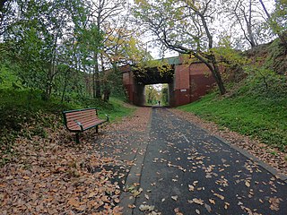
Roystead Railway Station was a railway station on the Outer Circle railway line, in the suburb of Canterbury, in Melbourne, Australia. It was opened on 14 May 1900, as "Stanley", to serve passengers on the so-called Deepdene Dasher shuttle service. This section of the line was in a cutting, and the station, with a single platform on the west side, was located south of a bridge, with red brick abutments and a green-painted iron superstructure, which took Mont Albert Road over the railway.
References
- David Beardsell and Bruce Herbert (1979). The Outer Circle: A history of the Oakleigh to Fairfield Park Railway. Australian Railway Historical Society (Victorian Division). ISBN 0-85849-024-2.
- "Malvern Urban Forest History". City of Stonnington. Retrieved 30 October 2022.