
The Battle of Towton took place on 29 March 1461 during the Wars of the Roses, near Towton in North Yorkshire, and "has the dubious distinction of being probably the largest and bloodiest battle on English soil". Fought for ten hours between an estimated 50,000 soldiers in a snowstorm on Palm Sunday, the Yorkist army achieved a decisive victory over their Lancastrian opponents. As a result, Edward IV deposed the Lancastrian Henry VI and secured the English throne.

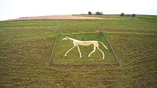
The Uffington White Horse is a prehistoric hill figure, 110 m (360 ft) long, formed from deep trenches filled with crushed white chalk. The figure is situated on the upper slopes of Whitehorse Hill in the English civil parish of Uffington in Oxfordshire, some 16 km (10 mi) east of Swindon, 8 km (5.0 mi) south of the town of Faringdon and a similar distance west of the town of Wantage; or 2.5 km (1.6 mi) south of Uffington. The hill forms a part of the scarp of the Berkshire Downs and overlooks the Vale of White Horse to the north. The best views of the figure are obtained from the air, or from directly across the Vale, particularly around the villages of Great Coxwell, Longcot, and Fernham.
The Vale of White Horse is a local government district of Oxfordshire in England. It was historically part of Berkshire. The area is commonly referred to as the 'Vale of the White Horse'. It is crossed by the Ridgeway National Trail in its far south, across the North Wessex Downs AONB at the junction of four counties. The northern boundary is defined by the River Thames. The name refers to Uffington White Horse, a prehistoric hill figure.

Kineton is a village and civil parish on the River Dene in south-east Warwickshire, England. The village is part of Stratford-on-Avon district, and in the 2001 census it had a population of 2,278, increasing to 2,337 at the 2011 Census.
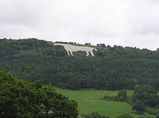
The Kilburn White Horse is a hill figure cut into the hillside in the North York Moors National Park near Kilburn in North Yorkshire, England.
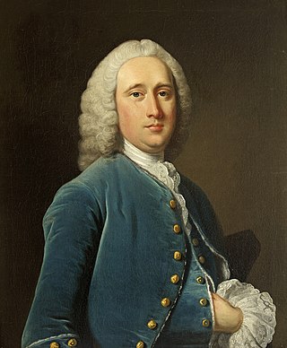
Sanderson Miller was an English pioneer of Gothic revival architecture and landscape designer. He is noted for adding follies or other Picturesque garden buildings and features to the grounds of an estate.

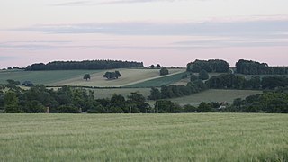
The Vale of Red Horse, also called the Vale of the Red Horse or Red Horse Vale, is a rural district in southern Warwickshire, England, lying between the escarpment of Edgehill and the northern Cotswolds around the valley of the Stour. Early gazetteers noted the Vale as a rich corn-growing area, and it is still relatively sparsely populated: its main settlements are Kineton and Shipston-on-Stour. The Fosse Way runs through the area and the Battle of Edgehill was fought on its fringes in October 1642.
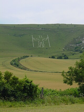
The Long Man of Wilmington or Wilmington Giant is a hill figure on the steep slopes of Windover Hill near Wilmington, East Sussex, England. It is 6 miles (9.7 km) northwest of Eastbourne and 1⁄3 mile (540 m) south of Wilmington. Locally, the figure was once often called the Green Man. The Long Man is 235 feet (72 m) tall, holds two "staves", and is designed to look in proportion when viewed from below.

A hill figure is a large visual representation created by cutting into a steep hillside and revealing the underlying geology. It is a type of geoglyph usually designed to be seen from afar rather than above. In some cases trenches are dug and rubble made from material brighter than the natural bedrock is placed into them. The new material is often chalk, a soft and white form of limestone, leading to the alternative name of chalk figure for this form of art.
Lightning Bar (1951–1960) was an American Quarter Horse who raced and subsequently became a breeding stallion. He was bred by his lifelong owner Art Pollard of Sonoita, Arizona, and was the offspring of Three Bars, a Thoroughbred, and Della P, a Quarter Horse mare from Louisiana, then noted for the breeding of sprint horses. Lightning Bar raced ten times, achieving four victories and four other top-three finishes. His racing career was cut short by illness after only one year, following which he spent two years as a show horse. As a breeding stallion, he sired seven crops, or years, of foals, among whom Doc Bar was the best known. In 1960 Lightning Bar died of an intestinal infection at the age of nine. He was inducted into the American Quarter Horse Association's (AQHA) Hall of Fame in 2008.

Cherhill White Horse is a hill figure on Cherhill Down, 3.5 miles east of Calne in Wiltshire, England. Dating from the late 18th century, it is the third oldest of several such white horses in Great Britain, with only the Uffington White Horse and the Westbury White Horse being older. The figure is also sometimes called the Oldbury White Horse.

Tysoe is a civil parish in the Stratford-on-Avon District of Warwickshire, England. The parish is on the boundary with Oxfordshire, about 7+1⁄2 miles (12 km) northwest of Banbury. The parish includes the contiguous villages of Middle and Upper Tysoe and the separate hamlet of Lower Tysoe. The 2011 census recorded the parish population as 1,143.
The Cerne Abbas Giant is a hill figure near the village of Cerne Abbas, in Dorset, England. It is currently owned by the National Trust, and listed as a scheduled monument of England. Measuring 55 metres (180 ft) in length, the hill figure depicts a bald, nude male with a prominent erection, holding his left hand out to the side and wielding a large club in his right hand. Like many other hill figures, the Cerne Giant is formed by shallow trenches cut into the turf and backfilled with chalk rubble.

Marlborough White Horse, also called the Preshute White Horse, is a hill figure on Granham Hill, a fairly shallow slope of the downland above the hamlet of Preshute, southwest of Marlborough in the county of Wiltshire, England. Dating from 1804, it is one of several such white horses to be seen around Great Britain, and one of nine in Wiltshire.

Alton Barnes White Horse is a chalk hill figure of a white horse located on Milk Hill some 1,000 metres north of the village of Alton, Wiltshire, England. The horse is approximately 180 feet high and 160 feet long, and was cut in 1812 under the commission of local farmer Robert Pile. Pile instructed inn sign painter John Thorne to design and cut the horse, although Thorne conned Pile by leaving with his advance sum while employing local resident John Harvey to cut the horse instead. It is based on another white horse hill figure in Wiltshire, the Cherhill White Horse, and is the second-biggest of nine white horses in Wiltshire.
Pewsey White Horse is a hill figure of a white horse near the village of Pewsey, Wiltshire, England. Cut of chalk in 1937, it replaces an earlier horse that had disappeared under the grass and is one of eight remaining white horses in Wiltshire. It measures 66’ by 45’, making it the smallest of the eight canonical white horses in Wiltshire.

Devizes White Horse, officially known as the Devizes Millennium White Horse, is a chalk hill figure of a horse located on Bank Field, an escarpment at Roundway Hill, on the outskirts of the town of Devizes above the hamlet of Roundway, Wiltshire, England; it is about ½ mile north of Roundway. It was cut in 1999 to celebrate the forthcoming third millennium, and is based on a design of another white horse hill figure, which was also known as Devizes White Horse, or sometimes The Snobs Horse, which was very close to the present horse as it was also on Roundway Hill beneath the Oliver's Castle hill fort. Traces of the Snobs Horse can still be seen under the right conditions.

Broad Town White Horse is a hill figure of a white horse located in the village of Broad Town, Wiltshire, England. One of eight canonical hill figures in Wiltshire depicting a white horse, it is carved into a 45° slope above Little Town Farmhouse and is visible for 20 miles. The horse is 80 by 60 feet in size and composed of fine compacted chalk with well defined edges. Although its origin is uncertain, according to William Plenderleath, writing in 1885, it was cut in 1864 by a William Simmonds, who held the farm then. Simmonds claimed later that it had been his intention to enlarge the horse gradually over the years, but he had to give up the farm and so did not have the opportunity.

Hackpen White Horse is a chalk hill figure of a white horse on Hackpen Hill, located below The Ridgeway on the edge of the Marlborough Downs, two miles south east of Broad Hinton, Wiltshire, England. It is one of nine white horse hill figures located in Wiltshire. It is also known as the Broad Hinton White Horse due to its proximity to the village. Supposedly cut by local parish clerk Henry Eatwell in 1838 to commemorate the coronation of Queen Victoria, the horse is 90 feet (27 m) wide by 90 feet (27m) high. The horse is regularly scoured and maintained.

The Litlington White Horse is a chalk hill figure depicting a horse, situated on Hindover Hill in the South Downs. It overlooks the River Cuckmere to the west of the village of Litlington and north of East Blatchington in East Sussex, England.

