Related Research Articles
Lenox is an unincorporated community in western Dent County, Missouri, United States. The community is located approximately twelve miles west of Salem at the intersection of routes H and C. Edgar Springs is approximately four miles to the northwest in adjacent Phelps County and the community of Maples is 4.5 miles to the south in Texas County.

Sherrill is an unincorporated community in northern Texas County, Missouri, United States. It is located approximately six miles north of Licking and is located just west of U.S. Route 63. Sherrill Creek flows past the north side of the community. The community of Beulah lies about 2.5 miles northwest on Sherrill Creek in Phelps County.

Seaton is an unincorporated community in southeastern Phelps County, Missouri, United States. It is located approximately thirteen miles southeast of Rolla.
Flat is an unincorporated community in southern Phelps County, Missouri, United States. It is located approximately sixteen miles southwest of Rolla. The community is at the intersection of Missouri routes M and T. Edgar Springs lies about four miles to the southeast at the intersection of route M and U.S. Route 63. The headwaters of Mill Creek are just to the east of the community. The village lies within the boundaries of the Mark Twain National Forest.
Service is an unincorporated community in eastern Crawford County, in the U.S. state of Missouri. The community is located on a small tributary along the east bank of Courtois Creek, approximately 2.5 miles west of the Crawford-Washington county line. Missouri Route 8 passes on the ridge about one-half mile to the southwest. The community of Butts lies about 1.5 miles downstream (northwest) and Berryman is about four miles to the southeast (upstream). The old Service School was located at the site in the 1940s.
Westover is an unincorporated community in Crawford County, in the U.S. state of Missouri. The community is on Dry Creek at the end of Missouri Route BB, approximately seven miles south-southeast of Steelville and five miles northeast of Cherryville.
Homeland is an unincorporated community in southwest Howell County, in the Ozarks of southern Missouri, United States. The community is located on U.S. Route 160, approximately four miles southwest of West Plains. Arrowhead Lakes on Spring Creek lie just to the southeast.
Blooming Rose is an unincorporated community in the southwest corner of Phelps County, in the U.S. state of Missouri. The community is on Missouri Route K between Beulah to the east and Duke to the north. Licking is approximately nine miles (14 km) to the southeast, in Texas County.
Craddock is an unincorporated community in southern Phelps County, in the U.S. state of Missouri. The community is one mile east of U.S. Route 63. Licking is approximately nine miles to the south in Texas County and Edgar Springs is about nine miles to the north.
De Camp is an extinct town in eastern Phelps County, in the U.S. state of Missouri. The community was located on the Elliott Branch of Norman Creek, approximately three-quarters of one mile east of Missouri Route F and about six miles south of St. James.
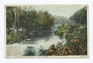
Little Piney Creek is a stream in the Phelps, Texas and Dent counties of the Ozarks of southern Missouri. It is a tributary of the Gasconade River.
Macedonia is an extinct town in northern Phelps County, in the U.S. state of Missouri.
Westcott is an extinct town in northwestern Phelps County, in the U.S. state of Missouri. The community lies on Missouri Route C approximately three quarters of a mile east of Tick Creek and three miles north-northwest of Doolittle and I-44.
Winkler is an unincorporated community in southeast Phelps County, in the U.S. state of Missouri. The community is located on Missouri Route 68, thirteen miles north of Salem and eleven miles south of St. James.
Yancy Mills is an unincorporated community in Phelps County, Missouri, United States.
Dagonia was an unincorporated community in western Reynolds County, in the U.S. state of Missouri. The community was on the east bank of Logan Creek along Missouri Route B. Reynolds is about seven miles to the north along Route B and Ellington lies approximately nine miles to the southeast.
Big Creek is an unincorporated community in Texas County, in the U.S. state of Missouri. The community was located along Big Creek, approximately 2.5 miles south of Yukon and one-half mile east of Missouri Route 137. The Big Creek school was south of the creek and the Big Creek church was about one-half mile north along a county road.
Samoa is an unincorporated community in Texas County, in the U.S. state of Missouri.
Stultz is an unincorporated community in southern Texas County, in the U.S. state of Missouri. The community is located on a tributary of Elk Creek, approximately 2.3 miles east-southeast of the community of Elk Creek.
Vessie is an extinct town in northern Phelps County, in the U.S. state of Missouri. The community is on a ridge between Kaintuck Hollow to the west and Little Piney Creek to the east at an elevation of 1060 feet. The community is at the intersection of Missouri Route T and a county road. It lies approximately four miles south of Newburg and is within the Mark Twain National Forest.
References
- ↑ U.S. Geological Survey Geographic Names Information System: Relfe (historical)
- ↑ Missouri, 1912-13-14: Resources, Advantages and Opportunities of a Thriving Commonwealth : Surplus Products, Missouri Counties, 1912, Other Commercial, Industrial, Social and Educational Details ... Missouri Bureau of Labor Statistics. 1914. p. 420.
- ↑ Flat, MO, 7.5 Minute Topographic Quadrangle, USGS, 1954 (1959 rev.)
- ↑ "Post Offices". Jim Forte Postal History. Retrieved 5 December 2016.
- ↑ "Phelps County Place Names, 1928–1945". The State Historical Society of Missouri. Archived from the original on June 24, 2016. Retrieved December 5, 2016.
Municipalities and communities of Phelps County, Missouri, United States | ||
|---|---|---|
| Cities |  | |
| Townships | ||
| Unincorporated communities | ||
| Ghost towns | ||
37°43′01″N91°58′56″W / 37.71694°N 91.98222°W
| | This United States ghost town-related article is a stub. You can help Wikipedia by expanding it. |
| | This Phelps County, Missouri state location article is a stub. You can help Wikipedia by expanding it. |