Related Research Articles

Phelps County is a county in the central portion of the U.S. state of Missouri. As of the 2020 United States Census, the population was 44,638. The largest city and county seat is Rolla. The county was organized on November 13, 1857, and was named for U.S. Representative and Governor of Missouri John Smith Phelps.
Clementine is an unincorporated community in western Phelps County, in the U.S. state of Missouri. It lies along the former U.S. Route 66. The community is located fourteen miles southwest of Rolla.

Northwye is a former community in Phelps County, Missouri, United States. It lies at the north junction of U.S. Routes 63 and 66, approximately one mile north of Rolla. The name refers to the Y-intersection of the two roads north of town.

Seaton is an unincorporated community in southeastern Phelps County, Missouri, United States. It is located approximately thirteen miles southeast of Rolla.
Flat is an unincorporated community in southern Phelps County, Missouri, United States. It is located approximately sixteen miles southwest of Rolla. The community is at the intersection of Missouri routes M and T. Edgar Springs lies about four miles to the southeast at the intersection of route M and U.S. Route 63. The headwaters of Mill Creek are just to the east of the community. The village lies within the boundaries of the Mark Twain National Forest.
Jerome is an unincorporated community in western Phelps County, Missouri, United States. It is located on the Gasconade River near Interstate 44, and is approximately ten miles west of Rolla, near the edge of the Mark Twain National Forest.
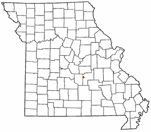
Vida is an unincorporated community in Phelps County, Missouri, United States. Vida is approximately six miles south of Rolla, near the junction of US Highway 63 and Missouri Route W. Vida is located at an elevation of 1033 feet above sea level. Vida can be found on Phelps County plat maps in Section 10, Township 36 N, Range 9 W.
Anutt is an unincorporated community in western Dent County, in the U.S. state of Missouri.
Spring Creek is a stream in Maries and Phelps counties of Missouri. It is a tributary of Gasconade River.
Dillon is an unincorporated community in Phelps County, in the U.S. state of Missouri. The community is located along the BNSF railroad line between Rolla and St. James.
Elk Prairie is an unincorporated community in Phelps County, in the U.S. state of Missouri. The community was located on Missouri Route 72 approximately seven miles south-southeast of Rolla.
Macedonia is an extinct town in northern Phelps County, in the U.S. state of Missouri.
Tick Creek is a tributary of the Gasconade River in northwestern Phelps County in the Ozarks of Missouri.
Arlington Township is an inactive township in Phelps County, in the U.S. state of Missouri.
Cold Spring Township is an inactive township in Phelps County, in the U.S. state of Missouri.
Dillon Township is an inactive township in Phelps County, in the U.S. state of Missouri.
Liberty Township is an inactive township in Phelps County, in the U.S. state of Missouri.
Meramec Township is an inactive township in Phelps County, in the U.S. state of Missouri.
St. James Township is an inactive township in Phelps County, in the U.S. state of Missouri.
Spring Creek Township is an inactive township in Phelps County, in the U.S. state of Missouri.
References
- ↑ U.S. Geological Survey Geographic Names Information System: Rolla Township, Phelps County, Missouri
- ↑ "Phelps County Place Names, 1928–1945". The State Historical Society of Missouri. Archived from the original on June 24, 2016. Retrieved December 5, 2016.
Municipalities and communities of Phelps County, Missouri, United States | ||
|---|---|---|
| Cities |  | |
| Townships | ||
| Unincorporated communities | ||
| Ghost towns | ||
37°55′24″N91°48′27″W / 37.9233°N 91.8075°W
| | This Phelps County, Missouri state location article is a stub. You can help Wikipedia by expanding it. |