
A chambered cairn is a burial monument, usually constructed during the Neolithic, consisting of a sizeable chamber around and over which a cairn of stones was constructed. Some chambered cairns are also passage-graves. They are found throughout Britain and Ireland, with the largest number in Scotland.

Rousay is a small, hilly island about 3 km (1.9 mi) north of Mainland, the largest island in the Orkney Islands of Scotland. It has been nicknamed "Egypt of the north", due to its archaeological diversity and importance.

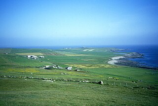
Sanday is one of the inhabited islands of Orkney that lies off the north coast of mainland Scotland. With an area of 50.43 km2 (19.5 sq mi), it is the third largest of the Orkney Islands. The main centres of population are Lady Village and Kettletoft. Sanday can be reached by Orkney Ferries or by plane from Kirkwall on the Orkney Mainland. On Sanday, an on-demand public minibus service allows connecting to the ferry.
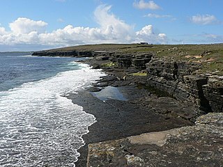
Westray is one of the Orkney Islands in Scotland, with a usual resident population of just under 600 people. Its main village is Pierowall, with a heritage centre, the 15th-century Lady Kirk church and pedestrian ferry service to nearby Papa Westray island. Westray has a number of archeological sites dating from 3500 BC, and remains of several Norse-Viking settlements. The spectacular sea cliffs around Noup Head are home to thousands of seabirds.
Papa Westray, also known as Papay, is one of the Orkney Islands in Scotland, United Kingdom. The fertile soil has long been a draw to the island.

Kilmartin Glen is an area in Argyll north of Knapdale. It has the most important concentration of Neolithic and Bronze Age remains in mainland Scotland. The glen is located between Oban and Lochgilphead, surrounding the village of Kilmartin. In the village, Kilmartin Museum explains the stories of this ancient landscape and the people who dwelt there. There are more than 800 ancient monuments within a six-mile (ten-kilometre) radius of the village, with 150 monuments being prehistoric. Monuments include standing stones, a henge monument, numerous cists, and a "linear cemetery" comprising five burial cairns. Several of these, as well as many natural rocks, are decorated with cup and ring marks.
Mine Howe is an Iron Age subterranean man-made chamber dug 6 meters deep inside a large mound. It is located in the Tankerness area of Orkney, Scotland, about 5 miles (8 km) southeast of Kirkwall, the capital of Orkney. The origin of the howe is not perfectly understood. Experts believe that it was built roughly 2000 years ago during the Iron Age. There is some similarity to the well inside the Iron Age Broch of Gurness.

Garynahine is a settlement on Lewis, in the Outer Hebrides, Scotland. Garynahine is situated at a T-junction where roads from Stornoway, Uig and the west side of Lewis all meet. The roads are the A858 and the B8011. Garynahine is within the parish of Uig.
Innerwick is a coastal civil parish and small village, which lies in the east of East Lothian, five miles from Dunbar and approximately 32 miles from Edinburgh.

Burroughston Broch is an Iron Age broch located on the island of Shapinsay in the Orkney Islands, in Scotland. The site overlooks the North Sea on the northeast part of Shapinsay. Excavated in the mid 19th century, Burroughston Broch is still well-preserved. The drystone walls are up to four metres thick in some parts and there is a complete chamber intact off the entrance passage. Some remains of stone fittings are evident in the interior.

Prehistoric Orkney refers only to the prehistory of the Orkney archipelago of Scotland that begins with human occupation. Although some records referring to Orkney survive that were written during the Roman invasions of Scotland, “prehistory” in northern Scotland is defined as lasting until the start of Scotland's Early Historic Period.
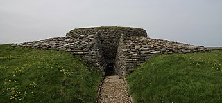
Quoyness chambered cairn is a Neolithic burial monument located on the island of Sanday in Orkney, Scotland. Similar to Maeshowe in design, the tomb was probably built around 3000 BC. The skeletal remains of several people were uncovered in the tomb during excavation in 1867. The monument was partially restored and reconstructed after a second excavation during the early 1950s, to display the different original stages of construction of the tomb. The property is now in the care of Historic Environment Scotland as a scheduled monument.

Bow Castle is the remains of an iron-age broch near the Gala Water, in the Scottish Borders area of Scotland, in the parish of Stow. It is a scheduled monument.

The architecture of Scotland in the prehistoric era includes all human building within the modern borders of Scotland, before the arrival of the Romans in Britain in the first century BCE. Stone Age settlers began to build in wood in what is now Scotland from at least 8,000 years ago. The first permanent houses of stone were constructed around 6,000 years ago, as at Knap of Howar, Orkney and settlements like Skara Brae. There are also large numbers of chambered tombs and cairns from this era, particularly in the west and north. In the south and east there are earthen barrows, often linked to timber monuments of which only remnants remain. Related structures include bank barrows, cursus monuments, mortuary enclosures and timber halls. From the Bronze Age there are fewer new buildings, but there is evidence of crannogs, roundhouses built on an artificial islands and of Clava cairns and the first hillforts. From the Iron Age there is evidence of substantial stone Atlantic roundhouses, which include broch towers, smaller duns. There is also evidence of about 1,000 hillforts in Scotland, most located below the Clyde-Forth line.

The remains of the Orphir Round Church, dedicated to Saint Nicholas, are located in Orphir Parish on the Mainland of Orkney, Scotland. It has been a scheduled monument since 2014.

The Wren's Egg is the name given to a set of late Neolithic or Bronze Age stone monuments in the parish of Glasserton, Wigtownshire, Dumfries and Galloway. The site comprises two pairs of standing stones to the north and south of a large glacial erratic, the Wren's Egg itself. It was one of the first monuments taken into state care after the Ancient Monuments Act passed in 1882.

The Knowes of Trotty is a Bronze Age cemetery located in Mainland, Orkney in Scotland. The ancient site consists of a group of twelve surviving burial mounds, dating to 2030–1770 BC. Along with cremated human remains, four gold discs and a number of amber beads and pendants were discovered in the largest mound in 1858. Knowes of Trotty is one of the earliest group of burial mounds in Orkney and one of the largest Bronze Age cemeteries in the United Kingdom.

Tofts Ness is a peninsula located on the north-east tip of the island of Sanday in Orkney, Scotland. It encompasses a prehistoric site which shows evidence of human occupation beginning in the late Neolithic Age and continuing through the Iron Age. The scheduled monument consists of mounds, cairns, enclosures, ancient soils and structural remains. Tofts Ness is also the location of multiple shipwrecks.

Quanterness chambered cairn is a Neolithic burial monument located on Mainland, Orkney in Scotland. An Iron Age roundhouse built into the cairn was discovered during excavation in the early 1970s. The dwelling was constructed around 700 BC. Also found during excavation, were the remains of 157 people, pottery remnants and other artefacts. Historic Environment Scotland established the site as a scheduled monument in 1929.


