
Orkney, also known as the Orkney Islands, is an archipelago in the Northern Isles of Scotland, situated off the north coast of the island of Great Britain. Orkney is 10 miles (16 km) north of the coast of Caithness and has about 70 islands, of which 20 are inhabited. The largest island, the Mainland, has an area of 523 square kilometres (202 sq mi), making it the sixth-largest Scottish island and the tenth-largest island in the British Isles. Orkney's largest settlement, and also its administrative centre, is Kirkwall.

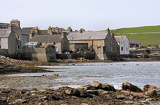
The Brough of Birsay is an uninhabited tidal island off the north-west coast of The Mainland of Orkney, Scotland, in the parish of Birsay. It is located around 13 miles north of Stromness and features the remains of Pictish and Norse settlements as well as a modern light house.

The Mainland, also known as Hrossey and Pomona, is the main island of Orkney, Scotland. Both of Orkney's burghs, Kirkwall and Stromness, lie on the island, which is also the heart of Orkney's ferry and air connections.
South Ronaldsay is one of the Orkney Islands off the north coast of Scotland. It is linked to the Orkney Mainland by the Churchill Barriers, running via Burray, Glimps Holm and Lamb Holm.
Birsay is a parish in the north west corner of The Mainland of Orkney, Scotland. Almost all the land in the parish is devoted to agriculture: chiefly grassland used to rear beef cattle. There are various ancient monuments in the parish.

St Magnus Cathedral dominates the skyline of Kirkwall, the main town of Orkney, a group of islands off the north coast of mainland Scotland. It is the oldest cathedral in Scotland, and the most northerly cathedral in the United Kingdom, a fine example of Romanesque architecture built for the bishops of Orkney when the islands were ruled by the Norse Earls of Orkney. It is owned not by the church, but by the burgh of Kirkwall as a result of an act of King James III of Scotland following Orkney's annexation by the Scottish Crown in 1468. It has its own dungeon.

The Bishop's Palace, Kirkwall is a 12th-century palace built at the same time as the adjacent St Magnus Cathedral in the centre of Kirkwall, Orkney, Scotland. It housed the cathedral's first bishop, William the Old of the Norwegian Catholic church who took his authority from the Archbishop of Nidaros (Trondheim). The ruined structure now looks like a small castle.

The Bishop of Orkney was the ecclesiastical head of the Diocese of Orkney, one of thirteen medieval bishoprics of Scotland. It included both Orkney and Shetland. It was based for almost all of its history at St Magnus Cathedral, Kirkwall.

Finstown is a village in the parish of Firth on Mainland, Orkney, Scotland. It is the fourth-largest settlement in the Orkney Islands.

Damsay is an islet in the Orkney archipelago in Scotland. It is approximately 18 hectares (0.07 sq mi) in extent and rises to only 11 metres (36 ft) above sea level. It is situated in the Bay of Firth north of the Orkney Mainland near Finstown. Nearby is the smaller islet of Holm of Grimbister.

The A961 is a single-carriageway road on the eastern side of Scapa Flow in the Orkney Islands, connecting the town of Kirkwall on the Orkney Mainland to Burwick at the southern end of South Ronaldsay.

RNAS Hatston, also called HMS Sparrowhawk, was a Royal Naval Air Station, one mile to the north west of Kirkwall on the island of Mainland, Orkney, Scotland. It was located near the strategically vital naval base of Scapa Flow, which for most of the twentieth century formed the main base of the ships of the Home Fleet.

Point of Ayre is a headland in the parish of Deerness, in the East Mainland of Orkney, Scotland. Overlooking the Copinsay Pass, it lies 4 miles (6 km) south of Mull Head, and around 10 miles from Kirkwall, the main town on the island.
Orphir is a parish and settlement on Mainland, Orkney. It is approximately 9 miles southwest of Kirkwall, and comprises a seaboard tract of about 7 by 3+1⁄2 mi, and includes Cava and the Holm of Houton. The coast includes Houton Head, about 300 feet tall, but all elsewhere is nearly level; and the interior is an assemblage of vales and hills, the latter culminating at about 700 ft (210 m) above sea level.

Deerness is a quoad sacra parish and peninsula in Mainland, Orkney, Scotland. It is about 13.5 kilometres (8.4 mi) south east of Kirkwall. Deerness forms a part of the civil parish of St. Andrews and Deerness. There is a shop/post office and a community centre and the Deerness Distillery.

Holm is a parish on Mainland, Orkney.

St Ola is a parish on Mainland, Orkney. It is in the centre of the island, east of the parish Firth and north of Holm. It contains the capital and largest town of the Orkney archipelago, Kirkwall. Both Kirkwall and St Ola may take their name from the church of St. Olaf, built about 1035 on the north bank of the Willow burn, which stands just below the local primary school.
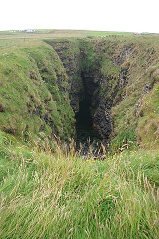
The Gloup is a collapsed sea cave in the Mull Head Nature Reserve in the islands of Orkney, Scotland.

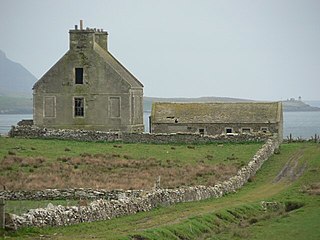
St Magnus Church, Birsay is a 17th century church located in the parish of Birsay on Mainland, Orkney in Scotland. Built in 1664 on the site of an earlier, 11th century church, St Magnus was later expanded in 1760 and 1867. The graveyard surrounding the church dates to the 18th century. The church is now maintained by the St Magnus Church Birsay Trust.
