
Saint-Jean-sur-Richelieu is a city in eastern Montérégie in the Canadian province of Quebec, about 40 kilometres (25 mi) southeast of Montreal. It is situated on the west bank of the Richelieu River at the northernmost navigable point of Lake Champlain. As of December 2019, the population of Saint-Jean-sur-Richelieu was 98,036.

Sainte-Julie, is an off-island suburb of Montreal, in southwestern Quebec, Canada, east of Montreal in Marguerite-D'Youville Regional County Municipality. The population as of the Canada 2021 Census was 30,045. In 2009 Sainte-Julie was called one of the best towns in which to live in Québec.

Chambly is an off-island suburb of Montreal in southwestern Quebec, Canada. It is located in the Montérégie region, inland from the South Shore of the Saint Lawrence River.
La Prairie is an off-island suburb of Montreal, in southwestern Quebec, Canada, at the confluence of the Saint-Jacques River and the Saint Lawrence River in the Regional County Municipality of Roussillon. The population as of the Canada 2011 Census was 23,357.

Mont-Saint-Hilaire is an off-island suburb of Montreal in southeastern Quebec, Canada, on the Richelieu River in the Regional County Municipality of La Vallée-du-Richelieu. The population as of the Canada 2011 Census was 18,200. The city is named after the Mont Saint-Hilaire.

Saint-Mathieu-de-Beloeil is a municipality in southwestern Quebec, Canada, east of Montreal in the Regional County Municipality of La Vallée-du-Richelieu. The population as of the 2021 Canadian Census was 2,952.

Carignan is a suburban municipality in southwestern Quebec, Canada, on the Richelieu River in La Vallée-du-Richelieu Regional County Municipality, about 27 km (17 mi) from Montreal. The population as of the Canada 2021 Census was 11,740.
Otterburn Park is a small town located 40 km east of Montreal, Quebec, Canada. The population as of the Canada 2011 Census was 8,450. The town lies south of Mont-Saint-Hilaire on the Richelieu River and is one of the number of officially bilingual towns in Quebec.

Saint-Bernard-de-Lacolle is a municipality in Les Jardins-de-Napierville Regional County Municipality, Quebec, Canada, located in the administrative area of Montérégie. Saint-Bernard-de-Lacolle was established officially in 1855, and its population as of the Canada 2016 Census was 1,549. A major border crossing, Blackpool, is located where St-Bernard-de-Lacolle abuts the village of Champlain, New York, at the junction of Quebec Autoroute 15 and U.S. Interstate 87.

Lacolle is a municipality in southern Quebec, Canada, located in the administrative area of the Montérégie, on the Canada–United States border. The population as of the Canada 2011 Census was 2,680. The Lacolle River runs eastward through the middle of the town and empties in Richelieu River. More people cross the border illegally from the United States there than at any other point. Almost nineteen thousand people were detained in 2017. The nearest town across the border is Champlain, New York.
Saint-Patrice-de-Sherrington is a municipality in Les Jardins-de-Napierville Regional County Municipality in Quebec, Canada, situated in the Montérégie administrative region. The population as of the Canada 2011 Census was 1,971.

Saint-Basile-le-Grand is a city located in La Vallée-du-Richelieu Regional County Municipality in southwestern Quebec, Canada. The population as of the 2011 Canadian Census was 16,736.
McMasterville is a municipality in southwestern Quebec, Canada on the Richelieu River in La Vallée-du-Richelieu Regional County Municipality. The population as of the 2016 Canadian Census was 5,695. It is within the Administrative Region of Montérégie.

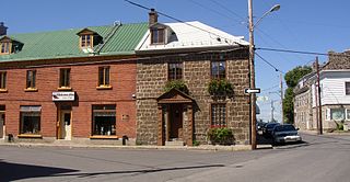
Saint-Blaise-sur-Richelieu is a municipality in the Canadian province of Quebec. The population as of the Canada 2016 Census was 2,066. The town was founded in 1892.

Marieville is a city in the Canadian province of Quebec. It is located within the Rouville Regional County Municipality in the Montérégie region about 30 kilometres (19 mi) east of Montreal. The population as of the Canada 2011 Census was 10,094.
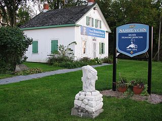
Sainte-Anne-de-Sabrevois is a parish municipality in the province of Quebec, Canada, located in the Regional County Municipality of Le Haut-Richelieu. The population as of the Canada 2011 Census was 2,074.

Sainte-Angèle-de-Monnoir is a municipality in the Canadian province of Quebec. The population as of the Canada 2011 Census was 1,812. It is located within the Rouville Regional County Municipality in the Montérégie region about 18 kilometers east of Chambly.

Rougemont is a municipality in the Canadian province of Quebec, located within the Rouville Regional County Municipality in the Montérégie region about 18 kilometers southwest of Saint-Hyacinthe. The population as of the Canada 2011 Census was 2,723.
Saint-Jean-Baptiste is a municipality in the Montérégie region of the Canadian province of Quebec. The population as of the Canada 2011 Census was 3,191. It is located within La Vallée-du-Richelieu Regional County Municipality in a valley between Mont Saint-Hilaire and Mont Rougemont.

Saint-Mathias-sur-Richelieu is a municipality in the Canadian province of Quebec. It is located within the Rouville Regional County Municipality in the Montérégie region on the Richelieu River. The population as of the Canada 2011 Census was 4,618.

