Vaudreuil-Dorion

Last updated

Vaudreuil-Dorion
Vaudreuil-Dorion1.JPG
Avenue Saint-Jean-Baptiste in Dorion
Blason MRC Vaudreuil-Soulanges.svg
Vaudreuil-Dorion Quebec location diagram.PNG
Location within Vaudreuil-Soulanges RCM
Canada Southern Quebec location map.png
Red pog.svg
Vaudreuil-Dorion
Location in southern Quebec
Coordinates: 45°24′N74°02′W / 45.400°N 74.033°W / 45.400; -74.033 [1]
Country Canada
Province Quebec
Region Montérégie
RCM Vaudreuil-Soulanges
Constituted16 March 1994
Government
  MayorGuy Pilon
   Federal riding Vaudreuil—Soulanges
   Prov. riding Vaudreuil
Area
  Total92.56 km2 (35.74 sq mi)
  Land72.65 km2 (28.05 sq mi)
Population
 (2021) [4]
  Total43,268
  Density595.5/km2 (1,542/sq mi)
  Pop 2016-2021
Increase2.svg 13.5%
  Dwellings
17,260
Time zone UTC−5 (EST)
  Summer (DST) UTC−4 (EDT)
Postal code(s)
Area code(s) 450, 579 and 354
Highways
Quebec Autoroute 20.svg A-20
Quebec Autoroute 30.svg A-30
Quebec Autoroute 40.svgTrans-Canada Highway shield.svg A-40 (TCH)

Qc338.svg R-338
Qc340.svg R-340
Qc342.svg R-342
Website www.ville.vaudreuil-dorion.qc.ca OOjs UI icon edit-ltr-progressive.svg

Vaudreuil-Dorion (French pronunciation: [vodʁœjdɔʁjɔ̃] ) is a suburb of Greater Montreal, in the Montérégie region of southwestern Quebec, Canada. The result of the merger of two towns, Vaudreuil and Dorion, it is located in the Vaudreuil-Soulanges Regional County Municipality.

Contents

History

On 23 November 1702, governor of New France Louis-Hector de Callière gave a seigneury to Philippe de Vaudreuil, who was governor of Montreal at the time. Rigaud de Vaudreuil later became governor of New France.

In 1725, the region had only 38 inhabitants. About 1742 people began to be interested in the region and Vaudreuil's population rose. 381 people lived in Vaudreuil in 1765. With the creation of the Grand Trunk Railway, people began to live in Dorion, which was called Vaudreuil Station. Dorion became a village in 1891.

Dorion was bisected by Autoroute 20 which links Downtown Montreal and Toronto via Highway 401 in Ontario. The Canadian National Railway and Canadian Pacific Railway links between Toronto and Montreal are located in Dorion. Housing developments began in the 1950s and continued well into the 1970s. Throughout the 1980s and the 1990s, housing began sprouting north and east of Dorion.

Vaudreuil and Dorion merged in 1994, becoming the City of Vaudreuil-Dorion.

Geography

Vaudreuil-Dorion is located on the south shores of the Lake of Two Mountains at the confluence of the Saint Lawrence and Ottawa Rivers, just off the western edge of Île Perrot. The city consists of two non-contiguous parts: its eastern part is the larger main area along Lake of Two Mountains where the population centres of Vaudreuil and Dorion are located; the western portion is a smaller rural area that borders Rigaud, and is separated from the eastern portion by Saint-Lazare and Hudson.

Demographics

Historical Census Data - Vaudreuil-Dorion, Quebec
YearPop.±%
1976 11,473    
1981 13,357+16.4%
1986 13,722+2.7%
1991 17,107+24.7%
1996 18,466+7.9%
YearPop.±%
2001 19,920+7.9%
2006 25,789+29.5%
2011 33,305+29.1%
2016 38,117+14.4%
2021 43,268+13.5%
Population amounts prior to 1994 are total of Dorion (Ville) and Vaudreuil (Ville).
Source: Statistics Canada

In the 2021 Census of Population conducted by Statistics Canada, Vaudreuil-Dorion had a population of 43,268 living in 16,713 of its 17,260 total private dwellings, a change of 13.5% from its 2016 population of 38,117. With a land area of 72.65 km2 (28.05 sq mi), it had a population density of 595.6/km2 (1,542.5/sq mi) in 2021. [5]

Canada census – Vaudreuil-Dorion community profile
2021 2016 2011
Population43,268 (13.5% from 2016)38,117 (+14.4% from 2011)33,305 (+29.1% from 2006)
Land area72.65 km2 (28.05 sq mi)72.73 km2 (28.08 sq mi)72.52 km2 (28.00 sq mi)
Population density595.5/km2 (1,542/sq mi)524.1/km2 (1,357/sq mi)459.3/km2 (1,190/sq mi)
Median age40.8 (M: 39.6, F: 41.6)38.6 (M: 38.0, F: 39.3)37.1 (M: 36.4, F: 37.8)
Private dwellings17,260 (total) 14,853 (total) 13,292 (total) 
Median household income$89,000$77,341$69,772
References: 2021 [6] 2016 [7] 2011 [8] earlier [9] [10]
Canada Census Mother Tongue - Vaudreuil-Dorion, Quebec
CensusTotal
French
English
French & English
Other
YearResponsesCountTrendPop %CountTrendPop %CountTrendPop %CountTrendPop %
2021
42,585
20,660Decrease2.svg 4.6%48.5%9,715Increase2.svg 23.1%22.8%1,505Increase2.svg 84.7%3.5%9,130Increase2.svg 43.3%21.4%
2016
37,590
21,665Increase2.svg 0.2%57.6%7,895Increase2.svg 21.6%21.0%815Increase2.svg 114.0%2.2%6,370Increase2.svg 50.5%17.0%
2011
32,590
21,245Increase2.svg 14.0%65.2%6,495Increase2.svg 56.1%19.9%610Increase2.svg 34.4%1.9%4,240Increase2.svg 82.4%13.0%
2006
25,400
18,630Increase2.svg 14.6%73.4%4,160Increase2.svg 57.9%16.4%285Increase2.svg 72.7%1.1%2,325Increase2.svg 294.1%9.2%
2001
19,650
16,260Increase2.svg 11.5%82.8%2,635Decrease2.svg 8.0%13.4%165Decrease2.svg 36.5%0.8%590Increase2.svg 22.9%3.0%
1996
18,185
14,580n/a80.2%2,865n/a15.8%260n/a1.4%480n/a2.6%

Local government

Vaudreuil-Dorion federal election results [11]
Year Liberal Conservative Bloc Québécois New Democratic Green
2021 49%9,52215%2,92122%4,34010%2,0212%419
2019 48%10,15111%2,32425%5,16611%2,2474%917
Vaudreuil-Dorion provincial election results [12]
Year CAQ Liberal QC solidaire Parti Québécois
2018 34%5,75738%6,54810%1,80211%1,878
2014 17%3,21857%10,9505%1,03718%3,465

Vaudreuil-Dorion forms part of the federal electoral district of Vaudreuil—Soulanges and has been represented by Peter Schiefke of the Liberal Party since 2015. Provincially, Vaudreuil-Dorion is part of the Vaudreuil electoral district and is represented by Marie-Claude Nichols, an independent MNA, since 2014.

List of former mayors: [13]

Transportation

The city is the point of intersection for three of Canada's busiest highways: Autoroute 40/Autoroute 30/Autoroute 20 (connecting the Quebec City-Windsor Corridor) and Highway 417 connects to Ottawa and Arnprior, Autoroute 20 and Highway 401 connects Toronto to Montreal and Autoroute 30 is Montreal's Southern Bypass.

Local bus service is operated by Exo La Presqu'Île, connecting to the Vaudreuil and Dorion stations on the Vaudreuil-Hudson commuter rail line.

Media

CJVD-FM operates studios in Vaudreuil-Dorion, broadcasting at 100.1 FM in Vaudreuil-Soulanges, the West Island and Valleyfield. On the air since 2008, CJVD airs a French and English hits format spanning from the 1960s to 1995.

Education

Commission scolaire des Trois-Lacs operates Francophone public schools:

Lester B. Pearson School Board operates Anglophone public schools:

Notable people

See also

Related Research Articles

<span class="mw-page-title-main">Pointe-Fortune, Quebec</span> Municipality in Quebec, Canada

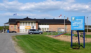
Pointe-Fortune is a municipality in southwestern Quebec, Canada, on the Ottawa River in Vaudreuil-Soulanges Regional County Municipality, northwest of Montreal. The population at the 2021 Census was 582.

<span class="mw-page-title-main">Rigaud, Quebec</span> City in Quebec, Canada

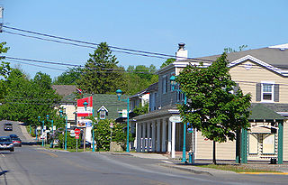
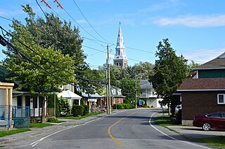
Rigaud is a city in southwestern Quebec, Canada, in the Vaudreuil-Soulanges Regional County Municipality in Vallée-du-Haut-Saint-Laurent region. It is located at the junction of the Ottawa River and the Rigaud River, about 70 kilometres (43 mi) west of downtown Montreal and 130 kilometres (81 mi) east of Ottawa. The population as of the Canada 2021 Census was 7,854.

<span class="mw-page-title-main">Vaudreuil-Soulanges Regional County Municipality</span> Regional county municipality in Quebec, Canada

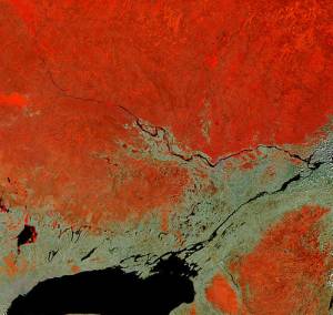
Vaudreuil-Soulanges is a regional county municipality in Quebec, Canada. It is located on a triangular peninsula in the western Montérégie region of Quebec, formed by the confluence of the Ottawa River to the north, and the St. Lawrence River to the south. Ontario is located west of here.

<span class="mw-page-title-main">Saint-Lazare, Quebec</span> City in Quebec, Canada

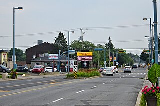
Saint-Lazare is an off-island suburb of Montreal, in southwestern Quebec, Canada in the Regional County Municipality of Vaudreuil-Soulanges.

Vaudreuil—Soulanges is a federal electoral district in Quebec, Canada, that has been represented in the House of Commons of Canada since 1867.

<span class="mw-page-title-main">L'Île-Perrot</span> City in Quebec, Canada

The Town of Île-Perrot is a town and municipality on Île Perrot in southwestern Quebec, Canada. The population as of the Canada 2016 Census was 10,756. The town is at the western end of Lake Saint-Louis, and borders the local island communities of Terrasse-Vaudreuil, Pincourt and Notre-Dame-de-l'Île-Perrot. It also includes Dowker Island and the small Claude and Bellevue Islands.

<span class="mw-page-title-main">Saint-Télesphore</span> Municipality in Quebec, Canada

Saint-Télesphore is a municipality located in Vaudreuil-Soulanges Regional County Municipality, Quebec (Canada). The population as of the 2021 Canadian census was 754. The municipality is situated west of Saint-Polycarpe, south of Sainte-Justine-de-Newton, north of Rivière-Baudette and east of the provincial border near North Lancaster, Ontario.

<span class="mw-page-title-main">Pincourt</span> City in Quebec, Canada

Pincourt is a municipality on the island of Île Perrot, off the western tip of the island of Montreal, Quebec. The population as of the 2021 Canadian census was 14,751. The town shares the island with the three other municipalities of Notre-Dame-de-l'Île-Perrot, Terrasse Vaudreuil and L'Île-Perrot, bordering on each one. The south end of the Ottawa River flows between Vaudreuil-Dorion and Pincourt, defining the town's western boundary.

<span class="mw-page-title-main">Terrasse-Vaudreuil</span> Municipality in Quebec, Canada

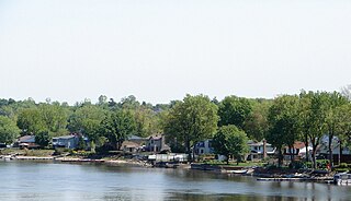
Terrasse-Vaudreuil is a small municipality on Île Perrot, just west of Montreal Island in Quebec, Canada. Attractions nearby include Le Faubourg de l'Île, the Terrasse-Vaudreuil baseball field, the soccer field, the municipal pool and POLYMOS, a styrofoam company that operates out of an area where gunpowder was produced during World War II. What started as a small cottage community has now evolved into miniature suburbia. Both entrances and exits of Terrasse-Vaudreuil are blocked by CP/CN train tracks, which has caused frustration in the past to residents. However, Terrasse does enjoy a beach that looks out onto Dorion and the Taschereau Bridge.

<span class="mw-page-title-main">Coteau-du-Lac</span> City in Quebec, Canada

Coteau-du-Lac is a small city in southwestern Quebec, Canada. It is on the north shore of the St. Lawrence River in the Vaudreuil-Soulanges Regional County Municipality.

<span class="mw-page-title-main">Saint-Zotique, Quebec</span> City in Quebec, Canada

Saint-Zotique is a city located within the Vaudreuil-Soulanges Regional County Municipality in the Montérégie region located about 45 minutes west of Montreal, Quebec, Canada. It is named for Saint Zoticus of Comana.

<span class="mw-page-title-main">Saint-Polycarpe, Quebec</span> Municipality in Quebec, Canada

Saint-Polycarpe is a municipality located in the Vaudreuil-Soulanges Regional County Municipality in the Montérégie region west of Montreal, Quebec, Canada, and just east of the Quebec-Ontario border. It was named for Polycarp, a 2nd-century bishop of Smyrna. The population as of the 2021 Canadian Census was 2,372.

<span class="mw-page-title-main">Très-Saint-Rédempteur</span> Municipality in Quebec, Canada

Très-Saint-Rédempteur is a municipality located in the Montérégie region of Quebec, Canada, along the border with Ontario. The population as of the Canada 2021 Census was 978. The municipality includes the town of Saint-Redempteur, and lies south of Rigaud along Route 325.

<span class="mw-page-title-main">Saint-Clet, Quebec</span> Municipality in Quebec, Canada

Saint-Clet is a municipality located in the Vaudreuil-Soulanges Regional County Municipality within the Montérégie region of Quebec, Canada. The population as of the 2021 Canadian census was 1,700. Completely surrounded by agricultural land, the town is centred on the intersection of two main provincial highways. The north–south Route 201 is known as rue Principale within the town limits, and the east–west Route 340 is known as Boulevard de la Cité des Jeunes.

<span class="mw-page-title-main">Les Cèdres, Quebec</span> Municipality in Quebec, Canada

Les Cèdres is a municipality located north of the Saint Lawrence River in the Montérégie of Quebec, Canada, near Vaudreuil-Dorion. The population as of the Canada 2021 Census was 7,184. The name means "The Cedars" in French.

<span class="mw-page-title-main">Sainte-Marthe, Quebec</span> Municipality in Quebec, Canada

Sainte-Marthe is a municipality located in the Vaudreuil-Soulanges Regional County Municipality of Quebec, Canada. The population as of the 2021 Canadian census was 1,014.

<span class="mw-page-title-main">Pointe-des-Cascades, Quebec</span> Village municipality in Quebec, Canada

Pointe-des-Cascades is a village municipality in Vaudreuil-Soulanges Regional County Municipality in the Montérégie region of Quebec, Canada. It is located on a spit of land where the St. Lawrence River flows into Lake Saint-Louis. The river has here a significant drop, forming several cascades which give the village its name. The islands of Île des Cascades and Île des Joybert are connected by a narrow causeway, but Île des Cascades and Pointe-des-Cascades are only connected artificially.

<span class="mw-page-title-main">Vaudreuil-sur-le-Lac</span> Village municipality in Quebec, Canada

Vaudreuil-sur-le-Lac is a village municipality in Vaudreuil-Soulanges Regional County Municipality in the Montérégie region of Quebec, Canada. It is located on the western portion of the Vaudreuil Peninsula, which projects into Lake of Two Mountains. The population as of the Canada 2016 Census was 1,341.

<span class="mw-page-title-main">L'Île-Cadieux</span> City in Quebec, Canada

L'Île-Cadieux is a village and municipality in the Montérégie region of Quebec, Canada, part of the Vaudreuil-Soulanges Regional County Municipality. It is located on and contiguous with Cadieux Island, which projects into Lake of Two Mountains just north off Vaudreuil-sur-le-Lac. The population as of the Canada 2011 Census was 105.

<span class="mw-page-title-main">Commission scolaire des Trois-Lacs</span> School district in Quebec, Canada

The Commission scolaire des Trois-Lacs is a former francophone school district in the Canadian province of Quebec. It comprises several primary schools and high schools across municipalities in the Montérégie region, and headquartered in Vaudreuil-Dorion. The commission was overseen by a board of elected school trustees. The three lakes referred to in the name are Lake of Two Mountains, Lake Saint-Louis, and Lake Saint Francis which surround much of the district.

References

  1. "Banque de noms de lieux du Québec: Reference number 287652". toponymie.gouv.qc.ca (in French). Commission de toponymie du Québec.
  2. 1 2 "Répertoire des municipalités: Vaudreuil-Dorion". www.mamh.gouv.qc.ca (in French). Ministère des Affaires municipales et de l'Habitation. Retrieved 16 May 2022.
  3. Parliament of Canada Federal Riding History: VAUDREUIL--SOULANGES (Quebec)
  4. 1 2 "Tableau des données, Profil du recensement, Recensement de la population de 2021". www12.statcan.gc.ca. Government of Canada - Statistics Canada. 9 February 2022.
  5. "Population and dwelling counts: Canada, provinces and territories, and census subdivisions (municipalities), Quebec". Statistics Canada. 9 February 2022. Retrieved 29 August 2022.
  6. "2021 Community Profiles". 2021 Canadian Census . Statistics Canada. 4 February 2022. Retrieved 16 May 2022.
  7. "2016 Community Profiles". 2016 Canadian Census . Statistics Canada. 12 August 2021. Retrieved 12 February 2017.
  8. "2011 Community Profiles". 2011 Canadian Census . Statistics Canada. 21 March 2019. Retrieved 19 February 2014.
  9. "2006 Community Profiles". 2006 Canadian Census . Statistics Canada. 20 August 2019.
  10. "2001 Community Profiles". 2001 Canadian Census . Statistics Canada. 18 July 2021.
  11. "Official Voting Results Raw Data (poll by poll results in Vaudreuil-Dorion)". Elections Canada. Retrieved 3 March 2023.
  12. "Official Voting Results by polling station (poll by poll results in Vaudreuil-Dorion)". Elections Québec. Retrieved 3 March 2023.
  13. "Répertoire des entités géopolitiques: Vaudreuil-Dorion (ville) 16.3.1994 - ..." www.mairesduquebec.com. Institut généalogique Drouin. Retrieved 19 January 2022.
  14. "Liste des bassins desservis par les écoles en 2017-2018." Commission Scolaire des Trois-Lacs. Retrieved on 30 September 2017.
  15. "School Board Map." Lester B. Pearson School Board. Retrieved on 28 September 2017.