Rideau Lakes

Last updated

Rideau Lakes
Township of Rideau Lakes
Rideau Lakes Twp.JPG
Municipal office
Township-rideau-lakes-map3.gif
Leeds and Grenville locator map 2021.svg
Red pog.svg
Rideau Lakes
Canada Southern Ontario location map 2.png
Red pog.svg
Rideau Lakes
Coordinates: 44°40′N76°13′W / 44.667°N 76.217°W / 44.667; -76.217
CountryFlag of Canada (Pantone).svg  Canada
ProvinceFlag of Ontario.svg  Ontario
County Leeds and Grenville
Incorporated1 January 1998
Government
  MayorArie Hoogenboom
  Federal riding Leeds—Grenville—Thousand Islands and Rideau Lakes
  Prov. riding Leeds—Grenville—Thousand Islands and Rideau Lakes
Area
[1]
  Land729.09 km2 (281.50 sq mi)
Population
 (2011) [1]
  Total10,207
  Density14.0/km2 (36/sq mi)
Time zone UTC-5 (EST)
  Summer (DST) UTC-4 (EDT)
Postal Code
K0E
Area code(s) 613, 343
Website www.twprideaulakes.on.ca

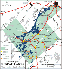
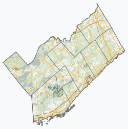
Rideau Lakes is a township located within Leeds and Grenville United Counties in Eastern Ontario, Canada. The township was incorporated on 1 January 1998 by amalgamating the former townships of North Crosby, South Crosby, Bastard, South Burgess and South Elmsley with the village of Newboro. [2]

Contents

Rideau Lakes lies in the northwest corner of Leeds and Grenville, and is geographically the largest municipality in the county.

Farming, tourism, and service industries form the backbone of the local economy. The many tourist attractions in Rideau Lakes, including historic trails, the stone arch dam at Jones Falls, and the Rideau Canal, are also an important part of the township's economy.

Rideau Lakes has 500 km (310 mi) of shoreline, excluding the Rideau Waterway. The waterway itself traverses the township, from the towering granite cliffs near Chaffeys Lock to the more gentle and pastoral areas of the Lower Rideau Lake. [3]

Communities

Rideau Lakes contains many villages and hamlets, including Chaffeys Lock, Chantry, Crosby, Daytown, Delta, Elgin, Forfar, Freeland, Harlem, Jones Falls, Lombardy, Morton, Newboro, Newboyne, Philipsville, Plum Hollow, Portland, Rideau Ferry, and Scotch Point. The township administrative offices are located in the hamlet of Chantry.

The independent village of Westport is entirely surrounded by Rideau Lakes, but is not part of the township.

The town of Smiths Falls is mostly located in Lanark County, while parts of the southern areas of the town is in the township of Rideau Lakes in the United Counties of Leeds and Grenville.

Newboro

A plaque was erected by the Ontario Heritage Foundation commemorating the founding of Newboro with the building of the Rideau Canal in 1826–32. Benjamin Tett settled here in 1833. He opened a store and later a post office. The community served as a major construction camp during the building of the Rideau Canal. Newboro was a trade centre for the region's lumbering industry and agriculture. The economic development of the community was enabled by the shipment of iron ore from local mines via the Rideau canal to smelters in Pittsburgh and Cleveland during the latter part of the 19th century. [4] The Village of Newboro was incorporated in 1876.

Chaffey's Lock

A plaque was erected by the Ontario Heritage Foundation commemorating the founding of Chaffey's Lock by Benjamin and Samuel Chaffey, who established mills here in 1820. Samuel Chaffey settling here shortly thereafter. The site included a distillery and saw, grist, carding, and fulling mills by 1827. The mills were flooded by the building of the Rideau Canal. A plaque was erected by the Chaffey's Lock and Area Heritage Society commemorating the founders, early builders, and all who have been part of the Chaffey's Lock community. Plaques have been erected by individuals and families on the Memory Wall, at Chaffey's Lock Cemetery.

The Queen's University Biological Station is located just southwest of Chaffey's Lock.

Trout island is a double island on the Rideau lakes; it became famous for its great trout fishing. There are three cottages on the island.

Tourism and attractions

The Rideau Trail, a 300-km footpath from Kingston to Ottawa, passes through the township. The highest point on the trail is located in the Foley Mountain Conservation Area, which is located within the township. The Cataraqui Trail, a rail trail on a former Canadian National right-of-way, goes through the township, passing near Portland, Elgin, and Chaffey's Lock. The Old Stone Mill National Historic Site is located within the village of Delta.

Demographics

In the 2021 Census of Population conducted by Statistics Canada, Rideau Lakes had a population of 10,883 living in 4,696 of its 6,781 total private dwellings, a change of 5.4% from its 2016 population of 10,326. With a land area of 711.81 km2 (274.83 sq mi), it had a population density of 15.3/km2 (39.6/sq mi) in 2021. [5]

Canada census – Rideau Lakes community profile
2021 2011
Population10,883 (+5.4% from 2016)10,207 (-1.4% from 2006)
Land area711.81 km2 (274.83 sq mi)729.09 km2 (281.50 sq mi)
Population density15.3/km2 (40/sq mi)14.0/km2 (36/sq mi)
Median age55.6 (M: 55.2, F: 55.6)
Private dwellings4,695 (total) 6258 (total) 
Median household income
References: 2021 [6] 2011 [7] earlier [8] [9]

Population trend: [10]

Mother tongue: [11]

See also

Related Research Articles

<span class="mw-page-title-main">Rideau Canal</span> Canal in Canada

The Rideau Canal is a 202 kilometre long canal that links the Ottawa River, at Ottawa, with the Saint Lawrence River at Kingston, Ontario, Canada. Its 46 locks raise boats from the Ottawa River 83 metres upstream along the Rideau River to the Rideau Lakes, and from there drop 50 metres downstream along the Cataraqui River to Kingston.

<span class="mw-page-title-main">United Counties of Leeds and Grenville</span> County in Ontario, Canada

The United Counties of Leeds and Grenville, commonly known as Leeds and Grenville, is a county in Ontario, Canada, in the Eastern Ontario subregion of Southern Ontario. It fronts on the Saint Lawrence River and the international boundary between Canada and the United States, opposite of the State of New York. The county seat is Brockville. The county was formed by the union of the historical counties of Leeds and Grenville in 1850.

<span class="mw-page-title-main">North Grenville</span> Municipality in Ontario, Canada

North Grenville is a township in eastern Ontario, Canada, in the United Counties of Leeds and Grenville on the Rideau River. It is located just south of Ottawa in Canada's National Capital Region.

<span class="mw-page-title-main">Westport, Ontario</span> Village in Ontario, Canada

Westport is a village in Eastern Ontario, Canada. It lies at the west end of Upper Rideau Lake, at the head of the navigable Rideau Canal system, 100 km (62 mi) southwest of Ottawa.

<span class="mw-page-title-main">Lanark County</span> County in Ontario, Canada

Lanark County is a county located in the Canadian province of Ontario. Its county seat is Perth, which was first settled in 1816.

<span class="mw-page-title-main">Drummond/North Elmsley</span> Township in Ontario, Canada

Drummond/North Elmsley is a township in eastern Ontario, Canada in Lanark County. It is situated on the north shore of the Rideau River between the town of Perth and the town of Smiths Falls. It is a predominantly rural municipality. The township offices are located in the hamlet of Port Elmsley.

<span class="mw-page-title-main">Tay Valley, Ontario</span> Township in Ontario, Canada

Tay Valley is a township in eastern Ontario, Canada, on the Tay River in the southwest corner of Lanark County, adjacent to the United Counties of Leeds and Grenville and Frontenac County. The township administrative offices are located in Glen Tay.

Leeds County is a historic county in the Canadian province of Ontario. The county was first surveyed in 1792 as one of the nineteen counties created by Sir John Graves Simcoe in preparation for the United Empire Loyalists to settle here. The county took its name from Francis Osborne, 5th Duke of Leeds; the "Leeds" of the Dukedom referred to Leeds in West Yorkshire, England and not for Leeds, Kent, England. In 1850, Leeds County merged with Grenville County to create the United Counties of Leeds and Grenville. This county was home to several townships as well as the city of Brockville.

<span class="mw-page-title-main">Nipissing, Ontario</span> Township in Ontario, Canada

Nipissing is an incorporated (political) township in Parry Sound District in Central Ontario, Canada. It is on Lake Nipissing and is part of the Almaguin Highlands region. Nipissing was surveyed between 1874 and 1881, and was incorporated in 1888. Among the first settlers in the area were the Chapman and Beatty families. Nipissing Township annexed Gurd Township in 1970. The township also contains a community named Nipissing, which is located on the South River near Chapman's Landing, on the South Bay of Lake Nipissing. The township administrative offices are located in Nipissing.

<span class="mw-page-title-main">Portland, Ontario</span> Police Village in Ontario, Canada

Portland is a police village and unincorporated place located in the municipal township of Rideau Lakes, United Counties of Leeds and Grenville in eastern Ontario, Canada. The community is on Ontario Highway 15 about 60 kilometres (37 mi) northeast of Ontario Highway 401 at Kingston by road, and is situated in geographic Bastard Township on the southeast side of Big Rideau Lake.

Burritts Rapids is a small village located on the Rideau River in eastern Ontario.

<span class="mw-page-title-main">Big Rideau Lake</span>

Big Rideau Lake is a lake in the municipalities of Tay Valley and Drummond/North Elmsley, Lanark County and Rideau Lakes, United Counties of Leeds and Grenville in Eastern Ontario, Canada. The lake is on the border between the two counties, 72 kilometres (45 mi) to the southwest of Ottawa. It is 32 kilometres (20 mi) long and is 6 kilometres (3.7 mi) wide, is much narrower at its northeastern end than at its southwestern end, and is part of the Saint Lawrence River drainage basin. It is the largest lake on the Rideau Canal, which was designated a UNESCO world heritage site in 2007.

Rideau Ferry is a small community in Eastern Ontario, Canada, along the Rideau Waterway. Rideau Ferry straddles a narrow stretch of water joining the Big Rideau Lake to the Lower Rideau Lake. At Rideau Ferry, the south shore of the Rideau Waterway is located within the Township of Rideau Lakes in Leeds and Grenville County, and the north shore is located within the township of Drummond/North Elmsley in Lanark County.

<span class="mw-page-title-main">Merrickville–Wolford</span> Village in Ontario, Canada

Merrickville–Wolford is a village-status municipality in Eastern Ontario, Canada, located in the United Counties of Leeds and Grenville. It spans both shores of the Rideau River.

<span class="mw-page-title-main">Leeds and the Thousand Islands</span> Township in Ontario, Canada

Leeds and the Thousand Islands is a township in the Canadian province of Ontario, located within the United Counties of Leeds and Grenville. The township is located along the Saint Lawrence River, and extends north into rural hamlets and villages. Formerly, this township was divided into three separate townships: Leeds, Lansdowne, and Escott townships; these townships amalgamated to form the current township of Leeds and the Thousand Islands.

John Robertson Dargavel was an Ontario farmer, merchant and political figure. He represented Leeds in the Legislative Assembly of Ontario from 1905 to 1919 as a Conservative member.

<span class="mw-page-title-main">Grenville, Quebec</span> Village municipality in Quebec, Canada

Grenville is a village municipality in the Argenteuil Regional County Municipality of the Laurentides region of Quebec, Canada. It is located opposite Hawkesbury, Ontario, on the Ottawa River.

Lake Opinicon is a lake in South Frontenac, Frontenac County and Rideau Lakes, United Counties of Leeds and Grenville in Eastern Ontario, Canada. This shallow lake was formed when Colonel John By built the Rideau Canal. It also is part of the Great Lakes Basin.

<span class="mw-page-title-main">Upper Rideau Lake</span>

Upper Rideau Lake is a freshwater lake located in the municipality of Rideau Lakes, United Counties of Leeds and Grenville in Eastern Ontario, Canada. It is located in the Saint Lawrence River drainage basin and is the lake with the greatest altitude within the Rideau Canal system.

King's Highway 42, commonly referred to as Highway 42, was a provincially maintained highway in the Canadian province of Ontario. The 52.8-kilometre (32.8 mi)-long route connected Highway 29 at Forthton with the town of Westport, intersecting Highway 15 en route. Highway 42 was assumed in 1935, and aside from paving the partially gravelled road, generally remained unchanged throughout its existence. In 1997, it was decommissioned and transferred to the United Counties of Leeds and Grenville, subsequently being redesignated as Leeds and Grenville County Road 42.

References

  1. 1 2 "Rideau Lakes census profile". 2011 Census of Population . Statistics Canada. Retrieved 2012-02-14.
  2. Ontario Summary of Municipal Restructuring
  3. Township of Rideau Lakes
  4. http://www.heritagefdn.on.ca/userfiles/HTML/nts_1_5888_1.html Ontario Heritage Trust Founding of Newboro
  5. "Population and dwelling counts: Canada, provinces and territories, census divisions and census subdivisions (municipalities), Ontario". Statistics Canada. February 9, 2022. Retrieved April 2, 2022.
  6. "2021 Community Profiles". 2021 Canadian Census . Statistics Canada. February 4, 2022. Retrieved 2022-04-27.
  7. "2011 Community Profiles". 2011 Canadian Census . Statistics Canada. March 21, 2019. Retrieved 2012-02-14.
  8. "2006 Community Profiles". 2006 Canadian Census . Statistics Canada. August 20, 2019.
  9. "2001 Community Profiles". 2001 Canadian Census . Statistics Canada. July 18, 2021.
  10. Statistics Canada: 1996, 2001, 2006 census
  11. Statistics Canada 2006 Census - Rideau Lakes community profile