Rio Virgen County, Utah Territory

Last updated

Rio Virgen County is a former county in the U.S. state of Utah. It was established by the Territory of Utah on February 1869. [1]

Contents

History

Iron County, Provisional State of Deseret; Washington County, Utah

Map of Oregon, Mexican Alta California, and Texas, with Alta California shown in pink. Printed 1846, the year U.S. military began its occupation of Alta California 1846 Mitchell's Map of Texas Oregon and California - Geographicus - TXORCA-mitchell-1846.jpg
Map of Oregon, Mexican Alta California, and Texas, with Alta California shown in pink. Printed 1846, the year U.S. military began its occupation of Alta California

Latter-day Saints, in 1839, two years after their initial arrival in Salt Lake Valley, within then uncolonized eastern Alta California, created the Provisional "Deseret," proposed to include the watersheds both of the Río Colorado and "Great Interior Basin" . [2] Deseret's provisional General Assembly in January 1850 established Little Salt Lake County (later that year renamed Iron County) with its southern boundaries' "extending south to the rim of the Basin." The U.S. Congress, in September, 1850, established Utah Territory, with its southern border instead at the 37th parallel.

Utah's legislature created Washington County in March 1852 as its southernmost county (and its northern boundary definitely defined in 1856 at "a line running east and west[...], through a point four miles north from the northeast corner of Fort Harmony"). [3]

Sought head of navigation on the Columbia

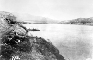
The Latter-day Saints' leader Brigham Young, sent an exploring party in 1855 to determine a possible head of navigation on the Colorado River that is, to "get the soundings of the river and see if it were navigable for boats" to transport Utah produce and import supplies through a steamship port on the Colorado River. Simultaneously, Young directed a portion of this party to found the then small LDS outpost of Las Vegas. In 1858, during the Utah War, Young sent a second party "to explore the Rio Colorado and the country adjacent to it for suitable locations for settlements." In 1864, Young's saying, "We shall shortly want another path to bring home the [Latter-day] Saints, and we want to prepare for it[...]. The Colorado is not far from our southern settlements, only one hundred twenty-five miles from Saint George," Young outfitted and dispatched a Church mission that founded Call's Landing (Callville) on the Colorado.

Church mission on the Muddy River

The following year after the founding of Call's Landing, Young sent missions to found settlements on a Colorado River tributary, the Muddy River, starting in January 1865. [4] [5] [6] [7] [8] [9]

'Arizona Strip's' creation in 1866

Utah's legislature in February 1865 suggested that Congress grant the areas to Utah within Arizona Territory north of canyonlands of the Colorado River (the present-day Arizona Strip as well as the western portion of Mohave County then in Arizona Territory). This would have cede jurisdiction over the settlements on the Muddy River and at the Beaver Dam Wash on the Virgin River to Utah. [10] Instead, in 1866 when Congress redrew Utah Territory's western border at 114° longitude, the Muddy River settlements were now below the Nevada Territory border; thus, even were it the case that Utah's border became redrawn southward, the Muddy River area would not be in Utah's confines.

Utah's legislature in February 1869 formed a runt "Rio Virgen County" from a small area nearby at very western part of Washington County (which it divided from the new county at Beaver Dam Wash, or at 115° longitude). [11] St. Thomas, settled in 1865 was established as Rio Virgen County's seat. In 1870, upon completion of U.S. governmnet surveys, Utah's ersatz Rio Virgen settlements acknowledged that they were in Pah-Ute County, Arizona Territory (18651871; whose area comprised those parts of Arizona Territory north of "Roaring Rapids" on the Colorado River and west of 113° 20” west longitude), with Pah-Ute County's seat at Callville.

Arizona's northwestern annexation to Nevada in 1867

Former Pah-Ute County, Arizona Territory's western portion annexed into Nevada Territory in 1867 and its eastern portion that remained in Arizona Territory Mormon settlement in Arizona - a record of peaceful conquest of the desert (1921) (14586622950).jpg
Former Pah-Ute County, Arizona Territory's western portion annexed into Nevada Territory in 1867 and its eastern portion that remained in Arizona Territory

Congress in 1867 annexed the portions of Pah-Ute County west of 114 degrees west longitude to Lincoln County, Nevada Territory. [13] (Utah came to formally annex "all that portion of Rio Virgin County now remaining in the Territory" back into Washington County on February 16, 1872. [3] [14] )

See also

Related Research Articles

<span class="mw-page-title-main">New Mexico Territory</span> Territory of the United States of America (1850–1912)

The Territory of New Mexico was an organized incorporated territory of the United States from September 9, 1850, until January 6, 1912. It was created from the U.S. provisional government of New Mexico, as a result of Nuevo México becoming part of the American frontier after the Treaty of Guadalupe Hidalgo. It existed with varying boundaries until the territory was admitted to the Union as the U.S. state of New Mexico. This jurisdiction was an organized, incorporated territory of the US for nearly 62 years, the longest period of any territory in the contiguous United States.

<span class="mw-page-title-main">Nevada Territory</span> Former organized incorporated territory of the U.S.

The Territory of Nevada (N.T.) was an organized incorporated territory of the United States that existed from March 2, 1861, until October 31, 1864, when it was admitted to the Union as the State of Nevada.

<span class="mw-page-title-main">State of Deseret</span> 1848–1850 provisional state founded by Mormons

The State of Deseret was a proposed state of the United States, proposed in 1849 by settlers from the Church of Jesus Christ of Latter-day Saints in Salt Lake City. The provisional state existed for slightly over two years and was never recognized by the United States government. The name derives from the word for "honeybee" in the Book of Mormon.

<span class="mw-page-title-main">Utah Territory</span> Territory of the U.S. between 1850-1896

The Territory of Utah was an organized incorporated territory of the United States that existed from September 9, 1850, until January 4, 1896, when the final extent of the territory was admitted to the Union as the State of Utah, the 45th state. At its creation, the Territory of Utah included all of the present-day State of Utah, most of the present-day state of Nevada save for Southern Nevada, much of present-day western Colorado, and the extreme southwest corner of present-day Wyoming.

<span class="mw-page-title-main">Historical regions of the United States</span>

The territory of the United States and its overseas possessions has evolved over time, from the colonial era to the present day. It includes formally organized territories, proposed and failed states, unrecognized breakaway states, international and interstate purchases, cessions, and land grants, and historical military departments and administrative districts. The last section lists informal regions from American vernacular geography known by popular nicknames and linked by geographical, cultural, or economic similarities, some of which are still in use today.

<span class="mw-page-title-main">Pah-Ute County, Arizona Territory</span> Former county in the Arizona Territory (1865–1871)

Pah-Ute County is a former county in the northwest corner of Arizona Territory that existed from 1865 until 1871, at which point most of the area was transferred to Nevada. The remainder was merged into Mohave County. The majority of the territory is now in Clark County, Nevada, which includes the city of Las Vegas. Due to the transfer of most of the county's land to Nevada, Pah-Ute is sometimes referred to as Arizona's "Lost County". Pah-Ute is an historic spelling of the tribal name Paiute.

<span class="mw-page-title-main">St. Thomas, Nevada</span> Ghost town in Clark County

St. Thomas, Nevada is a ghost town in Clark County, Nevada, near where the Muddy River flows into the Colorado River. St. Thomas was purchased by the US Federal Government and abandoned as the waters of Lake Mead submerged the town in the 1930s.

<span class="mw-page-title-main">Mormon corridor</span> Areas of the western US settled by the LDS Church

The Mormon corridor is the areas of western North America that were settled between 1850 and approximately 1890 by members of the Church of Jesus Christ of Latter-day Saints, who are commonly called "Mormons".

<span class="mw-page-title-main">Joseph S. Murdock</span> American hymnwriter

Joseph Stacy Murdock was an American colonizer, leader, and Latter-day Saint hymn writer. He wrote the words to "Come Listen to a Prophet's Voice."

<span class="mw-page-title-main">The Church of Jesus Christ of Latter-day Saints in Arizona</span> Aspect of church and state history

The Church of Jesus Christ of Latter-day Saints is the second-largest religious denomination in Arizona, behind the Roman Catholic Church. In 2022, the church reported 439,411 members in Arizona, about 6% of the state's population. According to the 2014 Pew Forum on Religion & Public Life survey, roughly 5% of Arizonans self-identify most closely with the Church of Jesus Christ of Latter-day Saints.

<span class="mw-page-title-main">The Church of Jesus Christ of Latter-day Saints in Nevada</span>

The Church of Jesus Christ of Latter-day Saints in Nevada refers to the Church of Jesus Christ of Latter-day Saints and its members in Nevada. Nevada has the 7th most church members of any U.S. state, and the fifth-highest percentage of members. The LDS Church is the 2nd largest denomination in Nevada, behind the Roman Catholic Church.

The 2nd Arizona Territorial Legislative Assembly was a session of the Arizona Territorial Legislature which began on December 6, 1865, in Prescott, Arizona, and ran for 24 days. The sessions chief accomplishments were creation of Pah-Ute County and establishing Arizona as a community property jurisdiction.

<span class="mw-page-title-main">Samuel Claridge</span> Mormon leader (1828–1919)

Samuel Claridge was a member of the Church of Jesus Christ of Latter-day Saints who was a prominent early settler of the Muddy River Valley in Nevada and Thatcher, Arizona.

<span class="mw-page-title-main">Callville Bay</span> Waterway in Nevada

Callville Bay is a waterway on the northwestern side of Lake Mead in the U.S. state of Nevada. It has a marina and camping resort. Situated east of Las Vegas and upstream from Las Vegas Bay, it lies within the Lake Mead National Recreation Area, which was established in 1935. Its name derives from the settlement of Callville which was established in 1865 by Anson Call under a directive led by Brigham Young. Though the settlement was abandoned in 1869, and submerged under Lake Mead when the Colorado River was dammed, Callville Bay retained the name.

<span class="mw-page-title-main">Callville, Nevada</span> Human settlement in United States of America

Callville is a former settlement of Clark County in the U.S. state of Nevada. Abandoned in 1869, it was submerged under Lake Mead when the Colorado River was dammed, Callville Bay retaining the name. At one time, it was noted to be the southernmost outpost of the Mormon settlement.

Octavius Decatur "O. D." Gass was an American prospector, businessman, and politician. A four term member of the Arizona Territorial Legislature, he was active in the early history of Las Vegas, Nevada and the creation of Pah-Ute County, Arizona Territory.

<span class="mw-page-title-main">Bonelli's Ferry</span> Unincorporated community in Nevada, United States

Bonelli's Ferry or Old Bonelli Ferry was a Colorado River ferry between Arizona and Nevada. It was located on the Colorado just above the Virgin River, near Junction City. The latter was later known as Rioville, Nevada in the late nineteenth century. Both the former sites of the ferry and of Rioville were submerged below Lake Mead, created by a dam on the Colorado River.

Stone's Ferry is a former settlement founded by members of the Church of Jesus Christ of Latter-day Saints and ferry crossing of the Colorado River between Nevada and Arizona, in Clark County, Nevada, United States.

<span class="mw-page-title-main">Seuvarits Utes</span> Band of the Northern Ute Native American tribe

The Seuvarits Utes are a band of the Northern Ute tribe of Native Americans that traditionally inhabited the area surrounding present-day Moab, Utah, near the Grand River and the Green River. The Seuvarits were among the Ute bands that were involved in the Black Hawk War. The Seuvarits and other Ute bands were eventually relocated onto reservations by the United States government after their population severely declined after exposure to disease and war during the latter half of the 19th century.

References

  1. "Helaman Pratt in Muddy Mission". jared.pratt-family.org.
  2. "Maps: When Two States Laid Claim to Los Angeles". 3 August 2015.
  3. 1 2 James B. Allen (1955). "The Evolution of County Boundaries in Utah". Utah Historical Quarterly . 23 (1–4).
  4. Milton R. Hunter (April 1939). "The Mormons and the Colorado River". American Historical Review . 44 (3): 549–555. doi:10.2307/1839902. JSTOR   1839902.
  5. "THE MUDDY MISSION". Deseret News. January 30, 1992.
  6. Muddy mission Online Nevada
  7. "150 Years Of Settlement On The Muddy Celebrated This Week". The Progress. January 7, 2015.
  8. G. Lynn Bowler (2004). Zion on the Muddy: The Latter-day Saints Settle the Muddy, and Organize Nevada's Oldest Stake. The Church of Jesus Christ of Latter-day Saints' Logandale Nevada Stake.
  9. L.A. Fleming (1967). "The Settlement of the Muddy 1865 to 1871 'A God Forsaken place'". Utah Historical Quarterly . 35 (2): 147–172. doi:10.2307/45058749. JSTOR   45058749. S2CID   254444151.
  10. Donald Bufkin. "The Lost County of Pah-Ute". Journal of Arizona History . 5: 5.
  11. George H. Hansen (1925). "A Regional Redistricting Plan for the State of Utah". Brigham Young University Studies : 14.
  12. James H. McClintock (1921). Mormon Settlement in Arizona: A Record of Peaceful Conquest of the Desert. AMS Press. p.  103.
  13. "Bounding the Silver State – Nevada Magazine". nevadamagazine.com.
  14. "Las Vegas 'stolen' from Arizona by Nevada - Tucson Citizen Morgue, Part 2 (1993-2009)". tucsoncitizen.com.