
The Sierra Nevada is a mountain range in the Western United States, between the Central Valley of California and the Great Basin. The vast majority of the range lies in the state of California, although the Carson Range spur lies primarily in Nevada. The Sierra Nevada is part of the American Cordillera, an almost continuous chain of mountain ranges that forms the western "backbone" of the Americas.

Inyo County is a county in the eastern central part of the U.S. state of California, located between the Sierra Nevada and the state of Nevada. In the 2020 census, the population was 19,016. The county seat is Independence. Inyo County is on the east side of the Sierra Nevada and southeast of Yosemite National Park in Central California. It contains the Owens River Valley; it is flanked to the west by the Sierra Nevada and to the east by the White Mountains and the Inyo Mountains. With an area of 10,192 square miles (26,397 km2), Inyo County is the second-largest county by area in California, after San Bernardino County. Almost one-half of that area is within Death Valley National Park. However, with a population density of 1.8 people per square mile, it also has the second-lowest population density in California, after Alpine County.

The Ansel Adams Wilderness is a wilderness area in the Sierra Nevada of California, United States. The wilderness spans 231,533 acres (93,698 ha); 33.9% of the territory lies in the Inyo National Forest, 65.8% is in the Sierra National Forest, and the remaining 0.3% covers nearly all of Devils Postpile National Monument. Yosemite National Park lies to the north and northwest, while the John Muir Wilderness lies to the south.

The John Muir Wilderness is a wilderness area that extends along the crest of the Sierra Nevada of California for 90 miles (140 km), in the Inyo and Sierra National Forests. Established in 1964 by the Wilderness Act and named for naturalist John Muir, it encompasses 652,793 acres (2,641.76 km2). The wilderness lies along the eastern escarpment of the Sierra from near Mammoth Lakes and Devils Postpile National Monument in the north, to Cottonwood Pass near Mount Whitney in the south. The wilderness area also spans the Sierra crest north of Kings Canyon National Park, and extends on the west side of the park down to the Monarch Wilderness.

Mount Charleston, including Charleston Peak at 11,916 feet (3,632 m), is the highest mountain in both the Spring Mountains and Clark County, in Nevada, United States. It is the eighth-highest mountain in the state. Well separated from higher peaks by large, low basins, Charleston Peak is the most topographically prominent peak in Nevada, and the eighth-most-prominent peak in the contiguous United States. It is one of eight ultra-prominent peaks in Nevada. It is located about 35 miles (56 km) northwest of Las Vegas within the Mount Charleston Wilderness, which is within the Spring Mountains National Recreation Area of the Humboldt–Toiyabe National Forest.
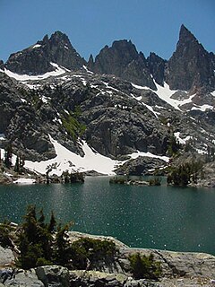
The Minarets are a series of jagged peaks located in the Ritter Range, a sub-range of the Sierra Nevada in the state of California. They are easily viewed from Minaret Summit, which is accessible by auto. Collectively, they form an arête, and are a prominent feature in the Ansel Adams Wilderness which was known as the Minaret Wilderness until it was renamed in honor of Ansel Adams in 1984.

Mount Ritter is the highest mountain in Madera County, California, in the Western United States, at an elevation of 13,149 feet (4,008 m). It is also the highest and most prominent peak of its namesake, the Ritter Range, a subrange of the Sierra Nevada in the Ansel Adams Wilderness of the Inyo and Sierra National Forests. Mount Ritter is the 15th highest mountain peak in California with at least 500 meters of topographic prominence.
Banner Peak is the second tallest peak in the Ritter Range of California's Sierra Nevada. The mountain is 12,942 feet (3,945 m) tall, and there are several glaciers on its slopes. It lies within the boundaries of the Ansel Adams Wilderness; at the foot of the peak lie Garnet Lake, Lake Ediza, and the famous Thousand Island Lake. Banner Peak is near the town of Mammoth Lakes; from there, climbers can hike to the foot of the mountain where various routes reach the summit, the easiest of which is a class 2 from the west end of Thousand Island Lake and then the saddle between Banner Peak and the slightly taller Mount Ritter. Other nearby lakes include Lake Catherine and Shadow Lake.

Ralston Peak is a mountain in the Sierra Nevada mountain range to the west of Lake Tahoe within the Desolation Wilderness in El Dorado County, California. Ralston Peak is a very popular mountain to summit for the views of the wilderness area as it lies very near U.S. Route 50. The closest trailhead to the summit can be found in Camp Sacramento a few miles west of Echo Summit. Ralston Peak can also be accessed from the Pacific Crest Trail between Echo Lake and Lake Aloha. Starting at the nearest trailhead, this route is significantly longer than the trail from Camp Sacramento. But the altitude gain on this route is much less, and the trail is much less steep.

Mount Tallac is a mountain peak southwest of Lake Tahoe, in El Dorado County, California. The peak lies within the Desolation Wilderness in the Eldorado National Forest. It is quite visible from State Routes 89 and 28, and U.S. Route 50. A "cross of snow" is clearly visible on the mountain's face during the winter, spring, and early summer months.

Jennie Lakes Wilderness is a protected area in the Sierra Nevada, in Tulare County, California. It is located 60 miles (97 km) east of Fresno and managed by the US Forest Service.

Minaret Summit is a mountain pass on Highway 203 in the central Sierra Nevada. The pass, lying on the Madera-Mono County border, is within the Mammoth Ranger District of the Inyo National Forest and located near Devils Postpile National Monument, Mammoth Lakes, and Mammoth Mountain. The elevation of the pass is about 9,265 ft (2,824 m). Highway 203 ends at Minaret Summit. The road continues, now called Reds Meadow Road, until its dead end at the Reds Meadow Pack Station near the Rainbow Falls trailhead.
Minaret Lake is a lake in the Ritter Range, a subrange of the Sierra Nevada, in California. It is located in extreme northeastern Madera County, within the Ansel Adams Wilderness of the Inyo National Forest.

Mount Starr, elevation 12,835 feet (3,912 m), is a mountain summit located on the crest of the Sierra Nevada mountain range in northern California, United States. It is situated in the John Muir Wilderness on the common boundary shared by Sierra National Forest with Inyo National Forest, and along the common border of Fresno County with Inyo County. It is bound on the east by Little Lakes Valley, and is 0.8 mile northeast of Mono Pass. Topographic relief is significant as the summit rises 2,300 feet (700 meters) above Little Lakes Valley in approximately one-half mile (1 km). Neighbors include Mount Abbot, three miles to the south-southwest, Mount Morgan, 2.5 miles to the southeast, and Pointless Peak is 2.5 miles to the north.
Muriel Peak is a 12,937-foot-elevation (3,943 meter) double summit mountain located in the Sierra Nevada mountain range in Fresno County, California, United States. The true summit is set within the John Muir Wilderness on land managed by Sierra National Forest, whereas the slightly lower south summit is on the boundary shared with Kings Canyon National Park. It is situated one mile northeast of Mount Goethe and one mile south of Muriel Lake. Muriel Peak is the 167th-highest peak in California, and topographic relief is significant as the summit rises 1,600 feet (488 meters) above Muriel Lake.

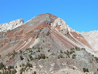
Iron Mountain is an 11,149-foot-elevation (3,398 meter) summit located in the Sierra Nevada mountain range in Madera County of northern California, United States. It is situated in the Ansel Adams Wilderness, on the boundary shared by Inyo National Forest with Sierra National Forest. It is set at the south end of the Ritter Range, approximately 10 miles (16 km) west of the community of Mammoth Lakes. Devils Postpile National Monument is 4.5 miles to the east and the Minarets are three miles to the north. Precipitation runoff from the west side of this mountain drains to North Fork San Joaquin River, and from the east slope to the Middle Fork San Joaquin. Topographic relief is significant as the east aspect rises over 2,000 feet (610 meters) above Anona Lake in approximately one mile. There are climbing routes to the summit via the south slope and east face, and inclusion on the Sierra Peaks Section peakbagging list generates climbing interest.
Mount Julius Caesar is a 13,213-foot-elevation mountain summit located on the crest of the Sierra Nevada mountain range in northern California, United States. It is situated in the John Muir Wilderness on the boundary that Sierra National Forest shares with Inyo National Forest, and along the common border shared by Fresno County with Inyo County. It is one mile southwest of line parent Bear Creek Spire, and 22 miles (35 km) west of the community of Bishop. Italy Pass is one-half mile immediately south of the summit, and Granite Park lies to the southeast. Mount Julius Caesar ranks as the 106th-highest summit in California. Topographic relief is significant as the summit rises 2,000 feet (610 meters) above Lake Italy in 0.7 mile (1.1 km).
Volcanic Ridge is an 11,486-foot-elevation (3,501 meter) ridge located in the Sierra Nevada mountain range in Madera County of northern California, United States. It is situated in the Ansel Adams Wilderness on land managed by Inyo National Forest. It is set in the Ritter Range, 1.9 miles (3.1 km) southeast of Mount Ritter, and approximately 10 miles (16 km) west of the community of Mammoth Lakes. The Minarets are one mile to the west and Devils Postpile National Monument is five miles to the southeast. Topographic relief is significant as the west aspect rises over 1,700 feet (520 meters) above Iceberg Lake in approximately one-half mile.
Herlihy Peak is an 11,758-foot-elevation (3,584 meter) mountain summit located in the Sierra Nevada mountain range in Mono County of northern California, United States. It is situated approximately four miles south of the community of Mammoth Lakes, in the John Muir Wilderness, on land managed by Inyo National Forest. Herlihy Peak is positioned midway between landmarks Crystal Crag and Bloody Mountain. Topographic relief is significant as the east aspect rises 2,060 feet (628 meters) above Valentine Lake in approximately one mile, and the west aspect rises 1,844 feet (562 meters) above Skelton Lake in 0.8 mile. Precipitation runoff from the peak drains to Mammoth Creek.
Relay Peak is a 10,338-foot-elevation mountain summit located in Washoe County, Nevada, United States.

