River Poulter

Last updated

River Poulter
Crookford - geograph.org.uk - 183044.jpg
The ford at Crookford, where a track crosses the Poulter
Location
Country England
County Nottinghamshire
Physical characteristics
Source 
  location Scarcliffe
Mouth River Idle
  location
Elkesley

The River Poulter which rises near Scarcliffe in Derbyshire, England is a tributary river of the River Idle in Nottinghamshire. It supplied power to mills along its route, most of which are now gone, although their mill ponds remain. Cuckney mill building is used as a primary school. The river has been dammed to create several lakes in the Dukeries estates of Welbeck Abbey and Clumber House now the National Trust property of Clumber Park. The ornamental Gouldsmeadow Lake, Shrubbery Lake and Great Lake on the Welbeck estate are supplied by a tributary of the Poulter, while Carburton Forge Dam and Carburton Dam were built to power a forge and a mill. Clumber Lake, consisting of an upper and lower lake, which is spanned by a Grade II* listed ornamental bridge, is part of the Clumber estate, and has suffered from subsidence.

Contents

Beyond the parklands, the river flows eastwards past Elkesley, to join the River Idle just outside the village close to the A1 road. The river's water quality is good, with most indexes showing that it is not far from being unpolluted enabling it to support populations of fish, while the lakes provide significant habitat for large numbers of birds.

Course

The Poulter rises at a spring to the south west of Scarcliffe in Derbyshire, close to the 520-foot (160 m) contour, and skirts around the southern edge of the village, before flowing in a north-easterly direction towards Nether Langwith. [1] At the western edge of Langwith, it passes under the abandoned track of the railway which served Langwith Colliery, and skirts around a modern fish farm. Owl Sick, a stream which rises at Owl Spring in Scarcliffe Park joins it near the village, and is joined by a stream which rises near Whaley Hall Farm, and flows in a south-easterly direction through Whaley and the Poulter Country Park. [2] The country park was the location of Langwith Colliery's waste tip. The colliery closed in 1978 and by 1987 most of the site had been cleared, although a shaft was retained to pump water from the pit into the river to keep the neighbouring Creswell Colliery drained. The waste tips were landscaped in 1988 to form the country park. [3]

The Langwith Viaduct carries the Robin Hood Line over the river at Langwith. Through the arch is the old pumphouse, which once supplied water to Langwith Colliery. RiverPoulterLangwithViaduct.JPG
The Langwith Viaduct carries the Robin Hood Line over the river at Langwith. Through the arch is the old pumphouse, which once supplied water to Langwith Colliery.

The streams flow into the millpond which supplied Scarcliffe Mill, one of four mills known to have existed along this stretch. Records from Newstead Priory indicate there was a mill here in 1432, and it was marked on maps of the late 19th century. By 1938 the last mill was no longer in use and was demolished in the 1960s. The mill pond has become silted as a result of the poor condition of the dam and sluice, but could form a central part of a conservation area based on Apsley Grange, a large building on the opposite side of the road. [4] Below the mill site, a small brick building once held the pumps used to regulate water levels in the river and pump water to Langwith Colliery. Next the river passes through an arch of a two-arched viaduct built in the 1870s by the Midland Railway. Although passenger traffic ceased in 1964, as part of the Beeching cuts, the line remained open for goods trains, and became part of the Robin Hood Line from Worksop to Nottingham in 1998. [4] The other arch crosses the Whaley Thorns road, under which the river flows immediately afterwards.

Passing through Langwith, the river splits into two channels which pass either side of some houses and rejoin at an open space where a stone sign indicates it the site of a sheep dip in 1896. The first of a series of lakes, "The Lake", covering an area of 5.4 acres (2.2 ha), [5] lies to the east of Nether Langwith, beyond which the flow is augmented by the treated output from Langwith Sewage Treatment Works.

Langwith Mill House marks the location of a cotton mill built in 1786. It had four storeys and was one of the largest of its type in the region. It closed in 1848 and was used as a corn mill from 1886. The building is in a poor state of repair, and on the Buildings at Risk Register. The mill house is a Grade II Listed building, [6] and housed a restaurant for a time, but is now empty. Soon the river splits, the northern channel dropping down, while the southern artificial channel maintains its level as it supplied the first of two mills at Cuckney. There have been mills here for several centuries, for a cotton mill was destroyed by fire in 1792. A lake called Cuckney Dam, covering 8.2 acres (3.3 ha), [5] provided the water to power its replacement, which ceased operation on 12 July 1844. After the machinery had been removed, the Duke of Portland turned the building into a National School. [7] The mill is now part of Cuckney Primary School, and its weir and sluices have been retained. [8] The drop in level of some 13 feet (4.0 m) between the mill pond and the river beyond has enabled the school to harness the river to generate electricity. Its 7 kW crossflow turbine [9] generating a significant proportion of the energy used by the school, [10] was funded by a grant from Powergen's Green Plan fund [11] and a Clear Skies grant.

Flowing around the northern edge of Cuckney, the river reaches the site of a second corn mill which was situated to the east of the village. The mill has been demolished, but the sluices and weir are still visible.

Welbeck Lakes

River Poulter
BSicon uexSTR.svg
River Idle
BSicon uexSTR+l.svg
BSicon uexABZgr.svg
mouth of River Poulter
BSicon uexSTR.svg
BSicon uexSTRl.svg
BSicon uexABZq+r.svg
BSicon uexSTR+r.svg
BSicon uexSKRZ-Au.svg
BSicon RAq.svg
BSicon uexSKRZ-Au.svg
A1 Road Twyford Bridge
BSicon uexSKRZ-Yu.svg
BSicon uexSTR.svg
BSicon uexSTR.svg
B6387 Bridge, Gamston
BSicon uexSTR.svg
BSicon uexSTR.svg
BSicon uexSTRl.svg
River Maun
BSicon uexSTR.svg
BSicon uexSTRl.svg
BSicon uexSTRq.svg
River Meden
BSicon uexABZgl.svg
BSicon uexSTR+r.svg
BSicon uexSTR.svg
BSicon uexSTR.svg
BSicon uexSTRl.svg
BSicon uexABZg+r.svg
BSicon uexSKRZ-Au.svg
A614 West Bridge
BSicon uexSKRZ-E.svg
Crookford ford
BSicon uxWEIRf.svg
weir
BSicon uexSKRZ-E.svg
Hardwick ford
BSicon uxWEIRf.svg
weir and cascade
BSicon uexRESVGDe.svg
Clumber Lake
BSicon uexDOCKSe.svg
BSicon uxWEIRf.svg
weir
BSicon uexSKRZ-Eu.svg
Clumber Bridge
BSicon uexBHF.svg
Clumber Upper Lake
BSicon uexSKRZ-Eu.svg
Carburton Bridge
BSicon utSTR+l.svg
BSicon uexABZgr.svg
sluices and culverts
BSicon uexSKRZ-Yu.svg
B6045 bridges, Carburton
BSicon uxWEIRf.svg
BSicon uxWEIRf.svg
sluices
BSicon uexSTRl.svg
BSicon uexRESVGe.svg
Carburton Dam (lake)
BSicon uxWEIRf.svg
cascade and sluice
BSicon uexRESVGDe.svg
Carburton Forge Dam (lake)
BSicon uexDOCKSe.svg
BSicon utSTRq.svg
BSicon utSTR+r.svg
culvert
BSicon uxWEIRf.svg
BSicon utSTR.svg
weir
BSicon uexRESVGDe.svg
BSicon utSTR+r.svg
BSicon uexSTR.svg
culvert
BSicon uexDOCKSe.svg
BSicon uexSTR.svg
BSicon uexSTR.svg
Welbeck Great Lake
BSicon uexBHF.svg
BSicon uexSTR.svg
BSicon uexSTR.svg
Shrubbery Lake
BSicon uexBHF.svg
BSicon uexSTR.svg
BSicon uexSTR.svg
Gouldsmeadow Lake
BSicon uexSTRr.svg
BSicon uexSTR.svg
BSicon uexSTR.svg
Millwood Brook
BSicon uexSKRZ-Yu.svg
BSicon uexSTR.svg
BSicon uexSTR.svg
BSicon uexSTR.svg
BSicon uxMILL.svg
Site of Cuckney Corn Mill
BSicon uexSTRl.svg
BSicon uexDOCKS.svg
BSicon uexSKRZ-Yu.svg
BSicon uexSKRZ-Au.svg
A60 bridge
BSicon uexSKRZ-Au.svg
A616 bridge
BSicon uexSTR+l.svg
BSicon uexABZgr.svg
BSicon uexSTR.svg
BSicon uxMILL.svg
Primary School (former Mill)
BSicon uxWEIRf.svg
BSicon uexBHF.svg
Cuckney Dam (lake)
BSicon uexABZg+l.svg
BSicon uexSTRr.svg
BSicon uxSTRbr.svg
Langwith Mill House
BSicon uexBHF.svg
The Lake, Nether Langwith
BSicon uxmKRZu.svg
Worksop to Nottingham Railway
BSicon uxSTRbr.svg
Site of Scarcliffe Mill
BSicon uexBHF.svg
Scarcliffe Mill pond
BSicon uexKHSTaq.svg
BSicon uexSTRq.svg
BSicon uexABZgr.svg
Poulter Country Park
BSicon uexSKRZ-Au.svg
A632 bridge
BSicon uexSTR.svg
BSicon uexSKRZ-Yu.svg
B6417 Scarcliffe Bridge
BSicon uexKHSTe.svg
spring

Beyond the mill site are two channels, the western at the level of the mill pond, and the eastern at a lower level. Both channels head towards the first ornamental lake supplied by the river. At this point, the river has dropped some 360 feet (110 m) from its source. Welbeck Great Lake is part of the Welbeck estate, which was owned by the Dukes of Portland, and now owned by the Bentinck family. Millwood Brook flows into Gouldsmeadow Lake and through Shrubbery Lake, before joining the Great Lake. In the 1760s, the duke employed the architect and civil engineer Robert Mylne to construct a three-arched bridge, which had to be both functional and beautiful. Mylne experienced problems with the piers moving, which resulted in the central 90-foot (27 m) arch collapsing in February 1768, after which Mylne was sacked. [12] In the 1840s, the fifth duke, who built an underground ballroom and tunnels on the estate, employed the engineer William Tierney Clark to construct a suspension bridge. The resident engineer for the project was Bland William Croker, who had assisted Clark with the construction of the Szechenyi suspension bridge in Budapest. [13] The western channel of the Poulter flows through a culvert into the Great Lake, while the lower eastern channel flows through a culvert into Carburton Forge Dam.

Beyond the lake, a weir with a track over it drops the level to Carburton Forge Dam, built to provide power for a forge. In 1695 10 acres (4.0 ha) of land were leased to John Wheeler of Worcester by the duke, on which he built the forge, a dam pool and floodgates. Deeds held by the Nottinghamshire Archive Service record an agreement between Wheeler and the duke to pay compensation annually as a result of the stream supplying the forge flooding the duke's land. [14] The forge flourished until the 1770s. A writer called Pococke described how "the pigs [of iron] were brought from Derbyshire to be melted into bars for use" in 1751. The fifth duke removed all traces of the forge. [15] Beyond Carburton Forge Dam, another weir drops the level to Carburton Dam. A "water corn mill, walke mill or fulling mill" was mentioned in a lease agreement in 1678. [16] The five Welbeck lakes cover an area of 151 acres (61 ha). [5]

Again there are two channels below the lake, with the main southern channel at a lower level than the northern one, which is called the Flood Dyke. Both cross under the B6034 Worksop to Ollerton road, and leave the Welbeck estate. The land between the two channels is sandy, and the Flood Dyke was used to irrigate the area, forming water meadows. Restoration of the historic structures was undertaken by the County Council in 2010/11, and interpretation boards have been erected to enable visitors to understand the process. [17] Following an archaeological survey, restoration work was carried out on the main sluice in the Flood Dyke, and on a number of stone sluices, wooden hatches and cast iron valves, the latter dating from the 19th century. [18]

Clumber Lake

Both channels pass under the road which serves the hamlet of Carburton, where the upper channel, Flood Dyke, ends in a field from where it enters a sluice and flows through a culvert into an open section. Water enters a second sluice and culvert and rejoins the lower channel. The upper sluice is marked "sluices" on the 1898 map, [19] and fed a large fish pond to the east of the channel. The fish pond was disused by 1919, when it was marked as swampy ground. [20] The lower channel flowed past the "Wheel House (pumping station)" in 1898. [19] It continues under Carburton bridge to supply Clumber Lake, part of the Clumber estate of the Dukes of Newcastle, which has been owned by the National Trust since 1945. The Clumber estate was described in the 18th century as "A black heath full of rabbits, having a narrow river running through it, with a small boggy close or two." [21] In 1772, the second Duke of Newcastle started construction of Clumber Lake, to complement his new house. A dam was built at the bottom end of the estate, the river bed was excavated to create a wide expanse of water, and an ornamental bridge was erected at the western end. The project took 15 years to complete, and cost £6,612. [22] The bridge, which consists of three unequal arches with balustrading along the top, was designed by Stephen Wright, and is 230 feet (70 m) long. It is a Grade II* listed structure. [23]

Improvements to the lake were carried out in 1786 under the direction of Mr Marson the estate manager. [24] The 4th Duke of Newcastle built a cascade below the bridge in 1823, [25] and a new one in 1835, when the work was completed by Mr Grey. The duke described the construction as "ingenious and well managed." [26] There were problems in 1842, when the culvert feeding water from the lake to an engine which supplied water to the house was found to be clogged with fine tree roots. [27] In spring 1845, 1846 and 1847, the duke drained the lake to make it wider and to improve the banks, which he felt looked "neither natural nor handsome" in places. [28]

Below the ornamental bridge, a weir drops the level by around 3.3 feet (1.0 m). In Victorian times, the park had two independent water supply systems, one supplying the house and its associated buildings, and the other supplying the farm and Hardwick village. About 500 people lived on the estate at the time. The house supply came from an artesian well, and was pumped to an underground reservoir, which held 60,000 imperial gallons (270 m3), from where it travelled 0.5 miles (0.80 km) by gravity. The difference in levels of the two parts of the lake was sufficient to power a Gilbert Gilkes and Gordon turbine, which drove the pump. The two systems became one in 1931, when a treble ram vertical pump was installed, driven by the existing turbine. Pumping is now done by electric pumps, but the original machinery is still in place, and was for a number of years used to supply the park with water if there was a power cut. [29]

The lake covering some 79 acres (32 ha) [5] has been affected by subsidence caused by coal mining, and UK Coal funded remedial work in the 1980s and in 2004. The lowering of the water level during this work revealed the charred remains of the Lincoln, a one-third scale naval frigate which the Duke bought in 1871, and which was destroyed by fire in the 1940s. [30] The river leaves the lake by a weir and cascade near Hardwick village, beyond which there is a ford, and another weir beyond that drops the level again, before the river passes under West Bridge on the A614 Worksop to Ollerton road. Most of the rest of the route is through woodland, in the middle of which a ford crosses the river near Crookford farm. The river is crossed by the B6387 Ollerton to Gamston road, and the A1 road near Gamston Airport, before joining the River Idle just downstream of the point where the River Maun and River Meden meet and the Idle begins.

Hydrology

The source of the Poulter is in a region where the underlying geology is an extensive water-bearing porous rock structure called the Magnesian Limestone aquifer. Magnesian limestone is named because if contains quantities of the mineral Dolomite, which is rich in Magnesium. Where this rock reaches the surface, springs often occur, and the Poulter starts at such a spring. Further to the east, the Magnesian Limestone is covered by a layer of porous rock called the Triassic Sherwood Sandstone aquifer, which is the major geological component of the area. Continuing eastwards, both are covered by a layer of Mercia mudstone. The groundwater levels in these aquifers affect whether they supply water to the river system, or take water from it, and levels are lower than they have historically been, as a result of the extraction of groundwater, particularly for public water supply, and by fracturing of the aquifers as a result of subsidence caused by deep coal mining. [31]

Above Cuckney, where the Environment Agency have a gauging station which records flows in the river, the catchment for the River Poulter covers some 12 square miles (31 km2), [32] which has an average annual rainfall of 24 inches (610 mm) (based on figures from 1961 to 1990). About a third of this finds its way into the river. [31] Water quality is good. The Environment Agency use a six-stage rating scale, from 'A' to 'F', the General Quality Assessment, to classify rivers. 'A' on the GQA is the best quality of water, while 'F' is the poorest. Factors which affect the quality are levels of ammonia, levels of dissolved oxygen and the Biochemical oxygen demand (BOD), which measures the amount of dissolved oxygen needed by organisms to break down organic matter in the water. These factors are generally worse when the water is discharged from sewage treatment processes, and tend to be worse in summer, when such discharges make up a greater proportion of the total flow in the river. The upper Poulter, above Welbeck Lake, is rated at 'B' on the GQA scale, despite the fact that the flows are augmented by the outflow from Langwith Sewage Treatment Works, which contributes around 1.2 Ml/d (megalitres per day) and by water from Langwith fish farm, which can be up to 0.9 Ml/d, but which is seasonal in nature. [33]

The river at Langwith RiverPoulterAtLangwith.jpg
The river at Langwith

Water quality remains good through the length of the river. Figures for the final section before it joins the River Idle show that the levels of ammonia and dissolved oxygen are those which would be expected in a natural ecosystem. Between 1991 and 2006, the BOD has been reduced by more than 50 per cent, but there is still room for improvement. Levels of phosphates and nitrates, which are affected by agricultural activity, are quite high, but some improvements have occurred. Water quality is also measured by two biological indexes. These are NTAXA, which relates to the total number of invertebrate species found in samples of the water, and ASPT, (the Average Score Per Taxon), calculated from the numbers of specific invertebrates which are graded according to their sensitivity to organic pollution. The assessment for the years 2004 to 2006 rated the final section as grade A (very good) on the first index, and grade B (good) on the second. This indicates that the water is not far short from unpolluted. [34]

The Environment Agency has since changed the system for assessing water quality in the river systems in England. Each is given an overall ecological status, which may be one of five levels: high, good, moderate, poor and bad. There are several components that are used to determine this, including biological status, which looks at the quantity and varieties of invertebrates, angiosperms and fish. Chemical status, which compares the concentrations of various chemicals against known safe concentrations, is rated good or fail. [35]

The water quality of the Poulter was as follows in 2019.

SectionEcological StatusChemical StatusLengthCatchment
Poulter from Source to Millwood Brook [36] Moderate Fail 7.7 miles (12.4 km)13.29 square miles (34.4 km2)
Millwood Brook Catchment (trib of Poulter) [37] Poor Fail 9.5 miles (15.3 km)17.61 square miles (45.6 km2)
Poulter from Millwood Brook to Maun [38] Poor Fail 9.4 miles (15.1 km)17.24 square miles (44.7 km2)

The quality of the Millwood Brook has improved, as it was rated bad for ecological status in 2009. Like many rivers in the UK, the chemical status changed from good to fail in 2019, due to the presence of polybrominated diphenyl ethers (PBDE) and mercury compounds, neither of which had previously been included in the assessment.

Flora and fauna

The river's upper reaches are diverse in terms of their physical nature and their ecological importance. They include an area of wet woodland providing a rich habitat for many species. [39] Water quality is sufficient to support various fish species. The river above Welbeck Lake provides habitat for a significant population of wild brown trout. The size of the lakes results in water moving much more slowly and supports populations of cyprinids, pike and eels, which thrive in water which is relatively static. The lower reaches of the river are used for spawning by fish which inhabit the River Idle. [33]

The lakes provide habitat for large numbers of birds. Clumber lake is fringed by alder, sallow and ash trees, with some sedge marsh. It was one of the first sites in the country used by gadwall for breeding, and also has a winter population of goosander. Hobbys frequent the reed bed below Clumber Dam in August and September, where they hunt swallows and martins. The upper lake is fringed by oak, yew, beech and Scots pine trees, and provides habitat for willow tits and woodpeckers, with blackcaps visiting in the summer. Mandarin ducks also visit occasionally. [40]

Points of Interest

Map all coordinates using: OpenStreetMap

Bibliography

Related Research Articles

<span class="mw-page-title-main">Old Bedford River</span> Watercourse in Cambridgeshire, England

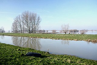
The Old Bedford River is an artificial, partial diversion of the waters of the River Great Ouse in the Fens of Cambridgeshire, England. It was named after the fourth Earl of Bedford who contracted with the local Commission of Sewers to drain the Great Level of the Fens beginning in 1630. It provided a steeper and shorter path for the waters of the Great Ouse, and was embanked to prevent them flooding the low ground of the South Fens. Throughout the project, the Earl and his Adventurers faced disruption from those who were opposed to drainage schemes. The project was deemed to have succeeded in draining the fens in 1637, but that decision was reversed in 1638. After a lull during the English Civil War, when much of the work was damaged, the Dutch engineer Cornelius Vermuyden worked with William Russell, the fifth Earl of Bedford to complete the drainage. Disruption and unrest continued while the work was carried out, resulting in the Adventurers employing armed guards. A second river, the New Bedford River, was cut parallel to the first channel, which then became the Old Bedford River. At some point, the Old Bedford River was split into two parts, when the upper section was diverted into the River Delph at Welches Dam, and the lower section was joined to the Counter Drain. Both parts retain the name, but are not connected to each other. The area between the two Bedford rivers acts as a large washland, which holds floodwater when the river channels cannot cope with the volume of water in them.

<span class="mw-page-title-main">New Bedford River</span> Watercourse in Cambridgeshire, England

The New Bedford River, also known as the Hundred Foot Drain because of the distance between the tops of the two embankments on either side of the river, is a navigable man-made cut-off or by-pass channel of the River Great Ouse in the Fens of Cambridgeshire, England. It provides an almost straight channel between Earith and Denver Sluices. It is tidal, with reverse tidal flow being clearly visible at Welney, some 19 miles (31 km) from the sea.

<span class="mw-page-title-main">River Rother, East Sussex</span> River in East Sussex and Kent, England

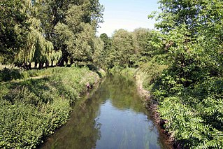
The River Rother flows for 35 miles (56 km) through the English counties of East Sussex and Kent. Its source is near Rotherfield in East Sussex, and its mouth is on Rye Bay, part of the English Channel. Prior to 1287, its mouth was further to the east at New Romney, but it changed its course after a great storm blocked its exit to the sea. It was known as the Limen until the sixteenth century. For the final 14 miles (23 km), the river bed is below the high tide level, and Scots Float sluice is used to control levels. It prevents salt water entering the river system at high tides, and retains water in the river during the summer months to ensure the health of the surrounding marsh habitat. Below the sluice, the river is tidal for 3.7 miles (6.0 km).

<span class="mw-page-title-main">River Idle</span> River in Nottinghamshire, England

The River Idle is a river in Nottinghamshire, England whose source is the confluence of the River Maun and River Meden near Markham Moor. The Idle flows north from its source through Retford and Bawtry before entering the River Trent at West Stockwith. Its main tributaries are the River Poulter and the River Ryton. The river is navigable to Bawtry, and there is a statutory right of navigation to Retford. Most of the land surrounding the river is a broad flood plain and the river is important for conservation, with Sites of Special Scientific Interest being designated along its course.

<span class="mw-page-title-main">River Meden</span> River in Nottinghamshire, England

The River Meden is a river in Nottinghamshire, England. Its source lies just north of Huthwaite, near the Derbyshire border, and from there it flows north east through Pleasley and Warsop before merging temporarily with the River Maun near Bothamsall. The rivers divide after a short distance and go on separately to a point near Markham Moor where they once more combine to form the River Idle.

<span class="mw-page-title-main">River Rother, South Yorkshire</span> River in South Yorkshire, England

The River Rother, a waterway in the northern midlands of England, gives its name to the town of Rotherham and to the Rother Valley parliamentary constituency. It rises in Pilsley in Derbyshire and flows in a generally northwards direction through the centre of Chesterfield, where it feeds the Chesterfield Canal, and on through the Rother Valley Country Park and several districts of Sheffield before joining the River Don at Rotherham in Yorkshire. Historically, it powered mills, mainly corn or flour mills, but most had ceased to operate by the early 20th century, and few of the mill buildings survive.

<span class="mw-page-title-main">River Ryton</span> River in Nottinghamshire, England

The River Ryton is a tributary of the River Idle. It rises close to the Chesterfield Canal near Kiveton Park, and is joined by a series of tributaries near Lindrick Common in the Metropolitan Borough of Rotherham, South Yorkshire, England. Most of its course is in Nottinghamshire, flowing through the town of Worksop. It meanders northwards to join the River Idle near the town of Bawtry on the South Yorkshire-Nottinghamshire border.

<span class="mw-page-title-main">River Nar</span> River in England

The River Nar is a river in England, a tributary of the River Great Ouse. It rises at Mileham near Litcham in Norfolk and flows 15 miles west through Castle Acre and Narborough, joining the Ouse at King's Lynn. It has had a variety of alternative names, such as the Setch, the Sandringham, and Lynn Flu, though these are rarely, if ever, used today. In 2011 the Nar was recognised by the Environment Agency as one of the top ten most improved rivers in England and Wales.

<span class="mw-page-title-main">River Lymn</span> River in Lincolnshire, England

The River Lymn is a river in Lincolnshire, England. It rises in the Wolds on the eastern slope of Castcliffe Hill in Fulletby parish. It flows south-eastwards to the Lincolnshire Marsh, where it becomes known as the Steeping River on the boundary of Great Steeping parish. The main channel is supplemented by the Wainfleet Relief Channel as it passes Wainfleet All Saints, and the relief channel is joined by the old course of the Lymn. Once the two channels rejoin, there are three flood defence structures to protect the region from flooding by the North Sea.

<span class="mw-page-title-main">Clumber Park</span> Estate in Worksop, Nottinghamshire, England

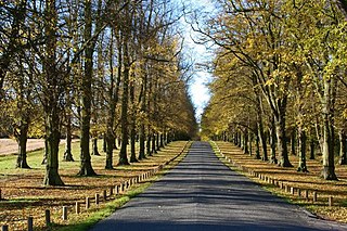
Clumber Park is a country park in The Dukeries near Worksop in Nottinghamshire, England. The estate, which was the seat of the Pelham-Clintons, Dukes of Newcastle, was purchased by the National Trust in 1946. It is listed Grade I on the Register of Historic Parks and Gardens.

<span class="mw-page-title-main">Cuckney</span> Human settlement in England

Cuckney is a village and former civil parish, now in the parish of Norton, Cuckney, Holbeck and Welbeck, in the Bassetlaw district of Nottinghamshire, England, located between Worksop and Market Warsop. In 2001 the parish had a population of 215.In 2001 the parish had a population of 31.
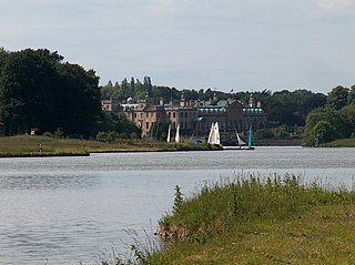
Carburton or Carberton is a small village on the west side of Clumber within the Bassetlaw district of Nottinghamshire, England. It is primarily rural and residential. The church of Saint Giles is an unusual shape and dates back to the early 12th century, parish records date back to the 1530s

<span class="mw-page-title-main">Rainworth Water</span> Tributary of the River Maun near Rainworth, Nottinghamshire, England

Rainworth Water is a watercourse that is a tributary of the River Maun near Rainworth, Nottinghamshire, England. It is characterised by a number of lakes, including that which forms part of the country park at Rufford Abbey. L Lake at Rainworth forms part of the Rainworth Lakes Site of Special Scientific Interest. There are two designated Local Nature Reserves along its length, one of which is also known by the name Rainworth Water. The Rainworth Water LNR is owned and managed by Nottinghamshire County Council.

<span class="mw-page-title-main">Welbeck</span> Human settlement in England

Welbeck is a village and former civil parish, now in the parish of Norton, Cuckney, Holbeck and Welbeck, in the Bassetlaw district, in Nottinghamshire, England. It is slightly to the south-west of Worksop. In 2001 the parish had a population of 31.

<span class="mw-page-title-main">Vicar Water</span> River in Nottinghamshire, England

Vicar Water is a small river in Nottinghamshire, England. It is a tributary of the River Maun, and runs through an area which was once the royal hunting ground of Clipstone Park. It gained its present name in the early nineteenth century, and was dammed in 1870, in order to make a trout fishery, which was used to stock the lakes at nearby Welbeck Abbey. Since the cessation of coal mining, much of it has been incorporated into a country park, and is a designated Local Nature Reserve.

<span class="mw-page-title-main">River Torne</span> River in the north of England

The River Torne is a river in the north of England, which flows through the counties of South Yorkshire and North Lincolnshire. It rises at the Upper Lake at Sandbeck Hall, in Maltby in South Yorkshire, and empties into the River Trent at Keadby pumping station. Much of the channel is engineered, as it plays a significant role in the drainage of Hatfield Chase, which it crosses.

<span class="mw-page-title-main">Norton and Cuckney</span> Civil parish in Bassetlaw, England

Norton and Cuckney is a former civil parish, now in the parish of Norton, Cuckney, Holbeck and Welbeck, in the Bassetlaw district, within the county of Nottinghamshire, England. The overall area had a population of 351 at the 2011 census. The parish lay in the north west of the county, and south west within the district. The parish lies close to the county border with Derbyshire. It is 125 miles north west of London, 20 miles north of the city of Nottingham, and 5 miles north of the market town of Mansfield. The area was bordering Sherwood Forest and has associations with mining interests and the Welbeck Estate.

<span class="mw-page-title-main">Clumber and Hardwick</span> Civil parish in England

Clumber and Hardwick is a civil parish in the Bassetlaw district, in the county of Nottinghamshire, England. The parish includes the settlement of Hardwick Village and Clumber Park, a country park. In 2011 the parish had a population of 198. The parish lies in the north west of the county, and south west within the district. It is 125 miles north west of London, 22 miles north of the city of Nottingham, and 3½ miles south east of the market town of Worksop.The parish touches Babworth, Carburton, Elkesley, Perlethorpe cum Budby and Welbeck. The parish was formed on 1 April 1994. The area is within Sherwood Forest and has close historical associations with the Dukes of Newcastle, being part of a wider region known as The Dukeries. There are 26 listed buildings in Clumber and Hardwick.

<span class="mw-page-title-main">Welbeck (Bassetlaw electoral ward)</span> Electoral ward in England

Welbeck is an electoral ward in the district of Bassetlaw. The ward elects one councillor to Bassetlaw District Council using the first past the post electoral system for a four-year term in office. The number of registered voters in the ward is 1,531 as of 2019.

<span class="mw-page-title-main">Norton, Cuckney, Holbeck and Welbeck</span> Civil parish in England

Norton, Cuckney, Holbeck and Welbeck is a civil parish in the Bassetlaw district of Nottinghamshire, England.

References

  1. Ordnance Survey, 1:25000 map, Sheet 269
  2. Ordnance Survey, 1:25000 map, Sheet 270, ISBN   0-319-23818-0
  3. "History". Langwith Community Website. Archived from the original on 27 July 2003. Retrieved 23 June 2010.
  4. 1 2 "Apsley Grange Conservation Area, Appraisal and Management Plan" (PDF). Bolsover District Council. October 2008. Archived from the original (PDF) on 31 August 2012. Retrieved 3 July 2010.
  5. 1 2 3 4 Palmer, Eric (2008). "Habitat Action Plan" (PDF). Notts Wildlife Trust. Archived from the original (PDF) on 24 April 2014. Retrieved 27 June 2010.
  6. "Buildings at Risk" (PDF). Bassetlaw District Council. p. 48. Archived from the original (PDF) on 6 March 2012. Retrieved 23 June 2010.
  7. "White's Directory of Nottinghamshire 1853, Norton Cuckney". Genuki. Archived from the original on 5 March 2016. Retrieved 21 June 2010.
  8. "The School's History". Cuckney CofE Primary School. Archived from the original on 5 August 2019. Retrieved 21 June 2010.
  9. "Project List". Derwent Hydroelectric Power. Archived from the original on 1 October 2010. Retrieved 24 June 2010.
  10. "Prospectus 2012/2013" (PDF). Cuckney CofE Primary School. p. 11. Archived from the original (PDF) on 16 April 2017. Retrieved 24 June 2010.
  11. "Micropower newsletter" (PDF). January 2006. p. 4. Archived from the original (PDF) on 20 February 2006. Retrieved 24 June 2010.
  12. Skempton 2002, p. 467.
  13. Cross-Rudkin 2008, p. 210.
  14. Notts Archives 2012, Agreement 157 DD/P/5/76, dated 5 June 1696.
  15. Firth 1916, p. 22.
  16. Notts Archives 2012, Agreement 157 DD/P/5/62, dated 1/2 Oct 1678.
  17. "Carburton". Sherwood Forest Visitors. Archived from the original on 17 May 2017. Retrieved 15 April 2017.
  18. "A case study of Nottinghamshire's water meadows" (PDF). River Restoration Centre (2011 Conference). pp. 32–38. Archived (PDF) from the original on 16 April 2017. Retrieved 15 April 2017.
  19. 1 2 Ordnance Survey, 1:2,500 map, 1898
  20. Ordnance Survey, 1:2,500 map, 1919
  21. Innes-Smith 1984, p. 14.
  22. "Clumber, Nottinghamshire" (PDF). The National Trust. Archived from the original (PDF) on 13 June 2010. Retrieved 21 June 2010.
  23. Historic England. "Clumber Bridge (1156520)". National Heritage List for England . Retrieved 27 June 2010.
  24. "Clumber Park" (PDF). Bassetlaw District Council. Archived from the original (PDF) on 23 February 2012. Retrieved 27 June 2010.
  25. Fletcher 2001, p. 26.
  26. Fletcher 2001, p. 151.
  27. Fletcher 2001, p. 254.
  28. Fletcher 2001, pp. 285, 287, 294, 300.
  29. National Trust, Clumber Park, Interpretation Board by pumping station
  30. "Clumber Park's Lost Treasures - The Lincoln". National Trust. Archived from the original on 8 February 2021. Retrieved 8 February 2021.
  31. 1 2 CAMS 2006, pp. 31–33.
  32. CAMS 2006, p. 29.
  33. 1 2 CAMS 2006, pp. 35–36.
  34. "A1 Elkesley Junction Improvements, Assessment Report" (PDF). Highways Agency. July 2008. Archived from the original (PDF) on 10 August 2012. Retrieved 4 July 2010.
  35. "Glossary (see Biological quality element; Chemical status; and Ecological status)". Catchment Data Explorer. Environment Agency. Retrieved 15 May 2017.
  36. "Poulter from Source to Millwood Brook". Catchment Data Explorer. Environment Agency.
  37. "Millwood Brook Catchment (trib of Poulter)". Catchment Data Explorer. Environment Agency.
  38. "Poulter from Millwood Brook to Maun". Catchment Data Explorer. Environment Agency.
  39. CAMS 2006, p. 16.
  40. "Clumber Park". Nottinghamshire Birds. Archived from the original on 21 July 2011. Retrieved 5 July 2010.

Commons-logo.svg Media related to River Poulter at Wikimedia Commons