Miami, officially the City of Miami, is a coastal metropolis located in southeastern Florida in the United States. It is the third most populous metropolis on the East coast of the United States, and it is the seventh largest in the country. The city has the third tallest skyline in the U.S. with over 300 high-rises, 55 of which exceed 491 ft (150 m).
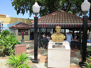
Little Havana is a neighborhood of Miami, Florida, United States. Home to many Cuban exiles, as well as many immigrants from Central and South America, Little Havana is named after Havana, the capital and largest city in Cuba.
Allapattah is a neighborhood mostly in the city of Miami, Florida, and partly in metropolitan Miami, United States. As of May 2011, the county-owned portion of Allapattah, from State Road 9 to LeJeune Road, is being annexed by the city proper.
Florida State Road 9 (SR 9) is a state road in the U.S. state of Florida. While SR 9 is mainly used as a state designation for Interstate 95 in Florida from the Golden Glades Interchange in Miami Gardens to the Georgia border, a signed SR 9, which is locally known in the Miami area as West 27th Avenue, Unity Boulevard, and historically Grapeland Boulevard, extends 13 miles (21 km) from the Coconut Grove section of Miami to the Golden Glades Interchange. The segment of I-95 south of the Golden Glades Interchange carries the designation of State Road 9A.
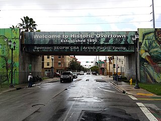
Overtown is a neighborhood of Miami, Florida, United States, just northwest of Downtown Miami. Originally called Colored Town during the Jim Crow era of the late 19th through the mid-20th century, the area was once the preeminent and is the historic center for commerce in the black community in Miami and South Florida.
State Road 933, locally known as West 12th Avenue, and Ronald W. Reagan Avenue, is a 4.25-mile (6.84 km) long north–south street entirely within the city limits of Miami, Florida. Its southern terminus is an intersection with Coral Way as Coral Way changes from Southwest 22nd Street to Southwest Third Avenue; its northern terminus is an interchange with the Airport Expressway. North of Dolphin Expressway, reassurance signage is virtually nonexistent, and the only indication of SR 933 existing north of Northwest 14th Street is a pair of trailblazer signs on Northwest 36th Street.
Thousands of years before Europeans arrived, a large portion of south east Florida, including the area where Miami, Florida exists today, was inhabited by Tequestas. The Tequesta Native American tribe, at the time of first European contact, occupied an area along the southeastern Atlantic coast of Florida. They had infrequent contact with Europeans and had largely migrated by the middle of the 18th century. Miami is named after the Mayaimi, a Native American tribe that lived around Lake Okeechobee until the 17th or 18th century.
Flagler Street is a 12.4-mile (20.0 km) main east–west road in Miami. Flagler Street is the latitudinal baseline that divides all the streets on the Miami-Dade County grid plan as north or south streets. Flagler Street is named after industrialist Henry Flagler and serves as a major commercial east–west highway through central Miami-Dade County, with a mixture of residential neighborhoods and strip malls, the commercial presence increasing as SR 968 approaches downtown Miami.
¿Qué Pasa, USA? is America's first bilingual situation comedy, and the first sitcom to be produced for PBS. It was produced and taped from 1977 to 1980 in front of a live studio audience at PBS member station WPBT in Miami, Florida and aired on PBS member stations nationwide.
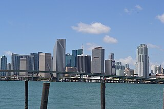
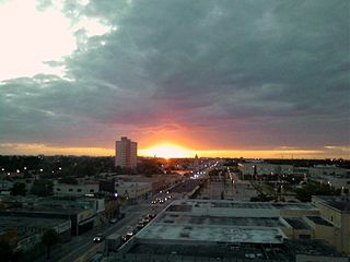
Downtown Miami is an urban city center, based around the Central Business District of Miami, Florida, United States. In addition to the central business district, the area also consists of the Brickell Financial District, Historic District, Government Center, Arts & Entertainment District and Park West. The neighborhood is divided by the Miami River and is bordered by Midtown to the north, Biscayne Bay to the east, Civic Center and Overtown to the west, and Coconut Grove to the south.

Miami Avenue is a 16.8-mile (27.0 km) main north–south street running through Coconut Grove, Brickell, Downtown, and Midtown in Miami, Florida. It is the meridian road dividing the street grid of Miami and Miami-Dade County into east and west avenues.

Miami Senior High School is a public high school located at 2450 SW 1st Street in Miami, Florida, United States, and operated by Miami-Dade County Public Schools. Founded in 1903, it is the oldest high school in Miami-Dade County. The school building is famous for its architecture and is a historic landmark. Miami Senior High School has a rich alumni base, with many graduates of the high school going on to varied, prominent careers. The high school originally served the earliest settling families of Miami in the first half of the 20th century. By the late 1960s, with an increase in Miami's population, its student body grew at a fast pace.

The Lummus Park Historic District or simply Lummus Park, is on the National Register of Historic Places and a locally historic designated district in Miami, Florida. It is roughly bound by Northwest Fifth Street to the north, Flagler Street to the south, Northwest Third Avenue to the east, and the Miami River to the west. On October 25, 2006, it was added to the U.S. National Register of Historic Places. Lummus Park has some of the oldest structures in Miami, and over the decades, has been able to retain a large part of its early pioneer character.

The Upper Eastside is a neighborhood in Miami, Florida, United States. It is north of Edgewater, east of Little Haiti, south of the village of Miami Shores, and sits on Biscayne Bay. In geographical order from south to north and east to west, it contains the subdivisions of Magnolia Park, Bay Point, Morningside, Bayside, Belle Meade, Shorecrest, and Palm Grove. The MiMo District along Biscayne Boulevard in the area is host to many art galleries, shops and restaurants.
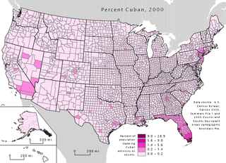
Cuban immigration has greatly influenced modern Miami, creating what is known as "Cuban Miami." However, Miami reflects global trends as well, such as the growing trends of multiculturalism and multiracialism; this reflects the way in which international politics shape local communities.

Buena Vista is a neighborhood in Miami, Florida, United States. It is located south of Little Haiti, north of the Miami Design District.

Miami-Dade County is located in the southeastern part of the U.S. state of Florida. According to a 2019 census report, the county had a population of 2,716,940, making it the most populous county in Florida and the seventh-most populous county in the United States. It is also Florida's third largest county in terms of land area, with 1,946 square miles (5,040 km2). The county seat is Miami, the principal city in South Florida.
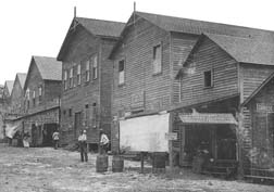
Grapeland Heights is a neighborhood in the city of Miami, Florida, United States. It is just east of Miami International Airport and north of Miami's West Flagler neighborhood. It is primarily a single-family residential neighborhood with a significant maritime industry along the neighborhood's eastern end along the Miami River.

The Greater Miami area, composed of the three counties of Miami-Dade, Broward, and Palm Beach, also known collectively as South Florida, is home to a wide variety of public and private transportation systems. These include heavy rail mass transit (Metrorail), commuter rail (Tri-Rail), automated guideway transit (Metromover), highways, two major airports and seaports, as well as three county-wide bus networks, which cover the entire urbanized area of South Florida. Census and ridership data show that Miami has the highest public transportation usage of any city in Florida, as about 17% of Miamians use public transportation on a regular basis, compared to about 4% of commuters in the South Florida metropolitan area. The majority of public transportation in Miami is operated by Miami-Dade Transit (MDT), which is currently the largest transit system in Florida and was the 14th largest transit system in the United States in 2011.

Central Business District (CBD) is the historic city center of what has become Greater Downtown Miami, in Miami, Florida, United States. It is generally bound by Biscayne Boulevard, Bayfront Park and Museum Park on the east, the Miami River to the south, North 6th Street to the north, and Interstate 95 to the west. While it is technically Miami's official "downtown", the term "Downtown Miami" has come to refer to a much larger 3.8-square-mile (10 km2) area along the bay from the Rickenbacker Causeway to the Julia Tuttle Causeway. It is also distinct from the financial district, which in this case is neighboring Brickell to the south. However, the downtown core has over 5,000,000 square feet (460,000 m2) of office space, including more than fifteen buildings with greater than 100,000 sq ft (9,300 m2) of floor space.