Edgewater is primarily a residential neighborhood, with many historic early 20th century homes. The neighborhood has many high-rise residential towers to the east along Biscayne Bay, and historic homes elsewhere in the neighborhood. Since 2000, the area has grown in popularity, due to its proximity to Downtown and neighborhoods such as the Design District. Recent developments in the neighborhood have brought rapid urbanization to the area, with the construction of high-rise and mid-rise residential buildings, and more retail.
As of 2000, Edgewater (Wynwood) had a population between 14,034[4] and 14,819[5] residents, with 6,221 households, and 2,987 families residing in the neighborhood. The median household income was $11,293.93. The racial makeup of the neighborhood was 58.51% Hispanic or Latino of any race, 17.51% Black or African American, 21.55% White (non-Hispanic), and 2.42% Other races (non-Hispanic). It shares demographics with Wynwood.[5]
The ZIP codes for the Edgewater (Wynwood) include 33127, 33132, and 33137. The area covers 1.679 square miles (4.35km2). As of 2000, there were 7,548 males and 6,486 females. The median age for males was 32.5 years old, while the median age for females was 32.3 years old. The average household size had 2.3 people, while the average family size was 3.2 members. The percentage of married-couple families (among all households) was 25.2%, while the percentage of married-couple families with children (among all households) was 10.9%, and the percentage of single-mother households (among all households) was 11.6%. 4.5% of the population was in other group homes. The percentage of never-married males 15 years old and over was 20.1%, while the percentage of never-married females 15 years old and over was 15.9%.[4]
As of 2000, the percentage of people that speak English not well or not at all made up 25.1% of the population. The percentage of residents born in Florida was 28.0%, the percentage of people born in another U.S. state was 20.5%, and the percentage of native residents but born outside the U.S. was 7.0%, while the percentage of foreign born residents was 44.4%[4]
Parks and Recreation
Margaret Pace Park, located along Biscayne Bay, is a key recreational area in Edgewater. It includes sports courts, picnic areas, running paths, outdoor gyms, and playgrounds. The park is frequently used by residents for activities such as yoga, cycling, and family outings.[6] The Baywalk is a pedestrian and bicycle path along Biscayne Bay that, once completed, will connect several waterfront neighborhoods. It aims to enhance public access to the bay and promote non-motorized transportation.[7]
Gallery
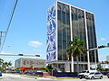
The Bacardi Building on NE 21 St and Biscayne Blvd, is a landmark building in Edgewater, built in the MiMo style
This page is based on this Wikipedia article Text is available under the CC BY-SA 4.0 license; additional terms may apply. Images, videos and audio are available under their respective licenses.