Riwaka

Last updated

Riwaka
Riwaka Tavern.JPG
The Riwaka Hotel
Riwaka
Coordinates: 41°5′S173°0′E / 41.083°S 173.000°E / -41.083; 173.000 Coordinates: 41°5′S173°0′E / 41.083°S 173.000°E / -41.083; 173.000
CountryNew Zealand
Territorial authority Tasman
WardMotueka Ward
Area
[1]
  Total5.49 km2 (2.12 sq mi)
Population
 (2018) [2]
  Total765
  Density140/km2 (360/sq mi)
Time zone UTC+12 (NZST)
  Summer (DST) UTC+13 (NZDT)
Area code03
Riwaka Memorial Hall Riwaka Memorial Hall.JPG
Riwaka Memorial Hall

Riwaka is a small settlement in the Tasman District of New Zealand's South Island. It lies beside Tasman Bay / Te Tai-o-Aorere, five kilometres north of Motueka, and close to the mouth of the Riuwaka River.

Contents

Riwaka means the hull of the waka. [3]

Demographics

Riwaka

Historical population
YearPop.±% p.a.
2006630    
2013657+0.60%
2018765+3.09%
Source: [2]

Riwaka, comprising the SA1 statistical areas of 7022557, 7022560, 7022561, 7022562 and 7022566, covers 5.49 km2 (2.12 sq mi). [1] It had a population of 765 at the 2018 New Zealand census, an increase of 108 people (16.4%) since the 2013 census, and an increase of 135 people (21.4%) since the 2006 census. There were 270 households. There were 396 males and 372 females, giving a sex ratio of 1.06 males per female, with 168 people (22.0%) aged under 15 years, 117 (15.3%) aged 15 to 29, 366 (47.8%) aged 30 to 64, and 111 (14.5%) aged 65 or older.

Ethnicities were 92.5% European/Pākehā, 14.1% Māori, 1.6% Pacific peoples, 2.0% Asian, and 2.7% other ethnicities (totals add to more than 100% since people could identify with multiple ethnicities).

Although some people objected to giving their religion, 66.3% had no religion, 21.2% were Christian, 0.4% were Hindu, 0.4% were Buddhist and 3.5% had other religions.

Of those at least 15 years old, 96 (16.1%) people had a bachelor or higher degree, and 114 (19.1%) people had no formal qualifications. The employment status of those at least 15 was that 333 (55.8%) people were employed full-time, 96 (16.1%) were part-time, and 12 (2.0%) were unemployed. [2]

Kaiteriteri-Riwaka statistical area

The larger Kaiteriteri-Riwaka SA2 statistical area includes Mārahau and Kaiteriteri and covers 28.57 km2 (11.03 sq mi). [1] It had an estimated population of 1,940 as of June 2021, [4] with a population density of 68 people per km2.

Historical populations for Kaiteriteri-Riwaka
YearPop.±% p.a.
20061,464    
20131,539+0.72%
20181,761+2.73%
Source: [5]

Kaiteriteri-Riwaka had a population of 1,761 at the 2018 New Zealand census, an increase of 222 people (14.4%) since the 2013 census, and an increase of 297 people (20.3%) since the 2006 census. There were 591 households. There were 915 males and 846 females, giving a sex ratio of 1.08 males per female. The median age was 44.5 years (compared with 37.4 years nationally), with 297 people (16.9%) aged under 15 years, 273 (15.5%) aged 15 to 29, 888 (50.4%) aged 30 to 64, and 306 (17.4%) aged 65 or older.

Ethnicities were 90.5% European/Pākehā, 10.4% Māori, 4.9% Pacific peoples, 1.4% Asian, and 2.7% other ethnicities (totals add to more than 100% since people could identify with multiple ethnicities).

The proportion of people born overseas was 23.7%, compared with 27.1% nationally.

Although some people objected to giving their religion, 62.5% had no religion, 26.1% were Christian, 0.2% were Hindu, 0.5% were Buddhist and 3.4% had other religions.

Of those at least 15 years old, 240 (16.4%) people had a bachelor or higher degree, and 258 (17.6%) people had no formal qualifications. The median income was $29,000, compared with $31,800 nationally. The employment status of those at least 15 was that 747 (51.0%) people were employed full-time, 279 (19.1%) were part-time, and 36 (2.5%) were unemployed. [5]

Education

Riwaka School is a co-educational state primary school for Year 1 to 8 students, [6] [7] with a roll of 196 as of March 2021. [8] The school, opened in 1848, is one of the oldest schools in New Zealand. [3]

Related Research Articles

Murchison, New Zealand Town in Tasman, New Zealand

Murchison is a town in the Tasman Region of the South Island of New Zealand. It is near the western end of the "Four Rivers Plain", at the confluence of the Buller River and the Matakitaki River. The other two rivers are the Mangles River, and the Matiri River. It is a rural service town for the surrounding mixed farming district, approximately halfway between Westport and Nelson. Murchison was named after the Scottish geologist Roderick Murchison, one of the founders of the Royal Geographical Society.

Motueka Town in Tasman District, New Zealand

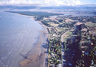
Motueka is a town in the South Island of New Zealand, close to the mouth of the Motueka River on the western shore of Tasman Bay / Te Tai-o-Aorere. It is the second largest in the Tasman Region, with a population of 8,280 as of June 2021.

Tapawera town in New Zealand

Tapawera is a small town in the Tasman District of New Zealand's South Island. It is located 76 km southwest of Nelson and 48 km southeast of Motueka. It is situated on the Motueka Valley Highway by the banks of the Motueka River.

Belmont, Wellington Suburb of Lower Hutt City in New Zealand

Belmont, a suburb of Lower Hutt, to the north of Wellington in the North Island of New Zealand, lies on the west bank of the Hutt River, on State Highway 2, the Wellington-Hutt main road, and across the river from the centre of Lower Hutt.

Tata Beach Settlement in Tasman, New Zealand

Tata Beach is a beach and small coastal settlement of predominantly holiday houses in the South Island, New Zealand. Found in the Golden Bay region, it is approximately 20 kilometres (12 mi) north-east of Takaka.

Dunsandel Place in Canterbury region, New Zealand

Dunsandel is a small rural town in the Canterbury region of the South Island, New Zealand. The town is located on the Canterbury Plains just south of the Selwyn River and about 40 km south of Christchurch. Dunsandel is a junction town on SH1, halfway between Christchurch and Ashburton, with roads leading to Leeston, Southbridge and Hororata. The town provides an important refreshment stop for main road travellers with eateries and coffee shops, as well as acting as a support town for the rural hinterland.

Māpua, New Zealand Village in Tasman District, New Zealand

Māpua is a small town in the South Island of New Zealand. It is to the west of Nelson on State Highway 60 and on the coastline of Tasman Bay.

Manutuke is a settlement in the Gisborne District of New Zealand's North Island. It is located to the west of the city of Gisborne on State Highway 2, close to the mouth of the Waipaoa River.

Kaiteriteri Place in Tasman, New Zealand

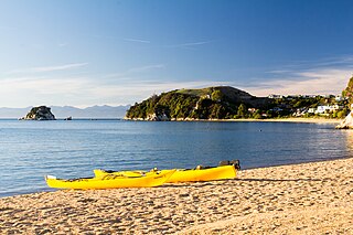
Kaiteriteri is a town and seaside resort in the Tasman Region of the South Island of New Zealand. It is close to both Marahau, the main gateway to Abel Tasman National Park, and the township of Motueka.

Mārahau Place in Tasman, New Zealand

Mārahau is a very small town in the Tasman Region of the South Island of New Zealand, approximately 19 kilometres (12 mi) north of Motueka. Its location on Tasman Bay / Te Tai-o-Aorere and at the southern entrance of Abel Tasman National Park makes it a popular holiday destination for those keen on outdoor activities. People access the Abel Tasman from Mārahau by tramping, kayaking and water taxi. In Mārahau itself, the beach offers sheltered and safe swimming, and horse trekking is popular throughout the busy summer season.

The Waimea Plains is a small but fertile area of low-lying land southwest of the port city of Nelson, situated on Tasman Bay / Te Tai-o-Aorere in the South Island of New Zealand. It is irrigated by the Waimea River from the Waimea Inlet in the north and bounded by the town of Brightwater in the south. The fertile soil promotes the growth of kiwifruit, apples and vineyards.

Appleby, New Zealand Locality in Tasman District, New Zealand

Appleby is a locality in the Tasman district in the South Island of New Zealand. It is located around the Waimea River near the Tasman Bay / Te Tai-o-Aorere. It was first settled in the early 1840s. State Highway 60 passes through the settlement.

Wakefield, New Zealand Locality in Tasman District, New Zealand

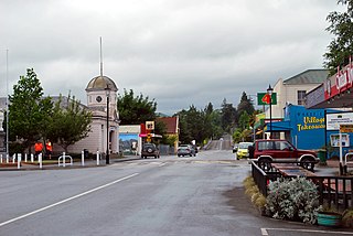
Wakefield is a settlement in the Tasman District of New Zealand's South Island, located about 25km south west of Nelson.

Hira is a small settlement approximately 20 kilometres (12 mi) northeast of Nelson, New Zealand. It sits in the valley of the Wakapuaka River.

Stepneyville Suburb in Nelson, Nelson, New Zealand

Stepneyville is a suburb of Nelson, New Zealand.

Monaco is a small suburb of Nelson, New Zealand, west of town centre of Stoke. It lies on a narrow peninsula which extends into Tasman Bay / Te Tai-o-Aorere immediately to the south of Nelson Airport, southwest of central Nelson.

Kai Iwi Place in Manawatū-Whanganui, New Zealand

Kai Iwi is a rural community west of Whanganui in New Zealand's North Island. It lies close to SH 3, approximately halfway between Whanganui and Waitotara. The population centre is at Kai Iwi Beach, also called Mowhanau.

Tasman (settlement) Rural settlement in Tasman, New Zealand

Tasman is a settlement in the Tasman District of New Zealand's upper South Island. It is located between Mapua and Motueka, 45 kilometres (28 mi) from Abel Tasman National Park and 40 kilometres (25 mi) from Nelson.

Lower Moutere is a settlement in the Tasman District of New Zealand's upper South Island. It is a farming community it the Lower Moutere valley, 6km from Motueka closed to the Moutere Inlet.

Ruby Bay is a settlement in the Tasman District of New Zealand's upper South Island. It is located between Māpua and Tasman on Te Mamaku / Ruby Bay.

References

  1. 1 2 3 "ArcGIS Web Application". statsnz.maps.arcgis.com. Retrieved 24 July 2021.
  2. 1 2 3 "Statistical area 1 dataset for 2018 Census". Statistics New Zealand. March 2020. 7022557, 7022560, 7022561, 7022562 and 7022566.
  3. 1 2 "Our History & Community". Riwaka School. Retrieved 24 July 2021.
  4. "Population estimate tables - NZ.Stat". Statistics New Zealand . Retrieved 22 October 2021.
  5. 1 2 "Statistical area 1 dataset for 2018 Census". Statistics New Zealand. March 2020. Kaiteriteri-Riwaka (300800). 2018 Census place summary: Kaiteriteri-Riwaka
  6. "Riwaka School Official School Website". riwaka.school.nz.
  7. "Riwaka School Ministry of Education School Profile". educationcounts.govt.nz. Ministry of Education.
  8. "Riwaka School Education Review Office Report". ero.govt.nz. Education Review Office.