Abel Tasman National Park

Last updated

Abel Tasman National Park
Totaranui Beach 01.jpg
New Zealand relief map.jpg
Disc Plain red.svg
Map of New Zealand
Location Tasman District, New Zealand
Nearest city Motueka
Coordinates 40°54′00″S172°58′16″E / 40.900°S 172.971°E / -40.900; 172.971
Area237.1 km2 (91.5 sq mi)
Established1942 [1]
Governing body Department of Conservation

Abel Tasman National Park is a New Zealand national park located between Golden Bay / Mohua and Tasman Bay at the north end of the South Island. It is named after Abel Tasman, who in 1642 became the first European explorer to sight New Zealand and who anchored nearby in Golden Bay.

Contents

Abel Tasman National Park is the smallest national park in New Zealand but has among the most visitors. [2] The Abel Tasman Coast Track, one of New Zealand's Great Walks, is a coastal tramping route spanning 60 kilometres (37 mi) along the eastern and northern coastal areas of the park. [3]

History

The coastal area was inhabited for hundreds of years by Māori prior to the arrival of Europeans, with sites throughout the area occupied both seasonally and permanently. In addition to harvesting food from the local forests, estuaries and waters, locals grew kūmara. [4]

Historical records indicate a was established at Auckland Point by Pohea, who travelled there around 1450 from the Whanganui area. From the mid-1500s Muaūpoko (formerly known as Ngāi Tara [5] ) occupied the area until the early 1600s, when they were ousted by Ngāti Tūmatakōkiri. Ngāti Tūmatakōkiri were present when Abel Tasman reached Golden Bay / Mohua in 1642. [6]

Park establishment

The park was founded in 1942, largely through the efforts of ornithologist and author Pérrine Moncrieff to have land reserved for the purpose. Moncrieff served on the park board from 1943 to 1974. [7]

The park was opened on 18 December 1942 to mark the 300th anniversary of Abel Tasman's visit. [8] Those in attendance at the opening ceremony at Tarakohe included Charles van der Plas, as personal representative of the Netherlands' Queen, Wilhelmina. The Queen was made Patron of the park. [9]

The idea for the park had been under consideration since June 1938. The Crown set aside 15,225 hectares (37,622 acres), comprising 8,900 hectares (21,900 acres) of proposed state forest, 5,809 hectares (14,354 acres) of Crown land and 554 hectares (1,368 acres) of other reserve land for the national park. [10] The Golden Bay Cement Company donated the land where the Abel Tasman Monument and a memorial plaque was sited. [8] The area's primary historic interest was the visit of Tasman in 1642, D'Urville in 1827, and the New Zealand Company barques Whitby and Will Watch, and brig Arrow in 1841. The site was also of significant botanical interest. [10]

Expansion

By 1946 the park had reached 15,534 hectares (38,386 acres) in area with additional land purchases. A further 844 hectares (2,085 acres) at Tōtaranui, formerly owned by William Gibbs, was acquired from J S Campbell in 1949 and added to the park. [11] About 6,100 hectares (15,000 acres) have been added since. In 2008 an extra 7.9 km2 (790 ha; 3.1 sq mi), including the formerly private land known as Hadfields Clearing, were added to the park. [12]

In 2016, a further 7 hectares (17 acres) in Awaroa Inlet was purchased by New Zealanders in a crowdfunding campaign.

Geography

Location and size

Rakauroa / Torrent Bay at Abel Tasman National Park. Torrent Bay 3, New Zealand.jpg
Rākauroa / Torrent Bay at Abel Tasman National Park.

Covering an area of 237 km2 (92 sq mi; 59,000 acres), [13] the park is the smallest of New Zealand's national parks. [4] It consists of forested, hilly country to the north of the valleys of the Tākaka and Riwaka Rivers, and is bounded to the north by the waters of Golden Bay / Mohua and Tasman Bay. The park contains some of the islands off the coast including the Tata Islands in Golden Bay / Mohua, and Tonga Island, Motuareronui / Adele Island, and Fisherman Island in Tasman Bay. [1]

The park does not extend beyond Mean High Water Mark on the adjacent coast. Between Mean High Water and Mean Low Water Springs, the beaches are gazetted as a Scenic Reserve, covering 7.74 km2 (2.99 sq mi) in total. The Tonga Island Marine Reserve adjoins part of the park.

The Abel Tasman Monument, though not located in the park, commemorates the first contact between Europeans and Māori and is located near the northern end of the park.

Ecology

Abel Tasman National Park stands out from most other National parks of New Zealand, given that a large area of it has undergone extensive environmental modification in its history. Early European settlers burned or cleared much of the forest, only to find that the soil was unsuitable for farming. This practise not only destroyed much of the shrubland and forests, but also introduced invasive plants found throughout the modern-day park. However, as time progresses, the original ecosystems and forests are slowly returning. [14]

The park contains varied habitats, including coastal forests, sub-alpine bogs, and sand dunes. As a result of this diversity, many different species can be found. The islands of the park, in particular Tonga Island, Motuareronui / Adele Island and Fisherman Island which are the largest, have been disturbed less and have no introduced mammalian predators. As a result the islands have species not found elsewhere in the park and there are more restrictions to visitor access. [4]

Flora

Though much of the parkland is pasture or covered with shrubs, valley areas contain forests of rātā, mataī, miro and hinau. [15]

Fauna

Over 70 species of birds have been recorded in the park. Some of the birds that can frequently be seen are petrels, shags, penguins, gulls, terns, and herons. Possums, wild pigs, deer, and goats can also be seen in the park. [1]

Conservation and human interaction

Activities and access

The Abel Tasman Coast Track is a popular tramping track that follows the coastline and is one of the Department of Conservation's Great Walks; the Abel Tasman Inland Track is less frequented. Other walks in the park, such as the Wainui Falls Track are considered 'short walks'. [16] Kayaking, camping and sightseeing are other activities.

Access to the park is usually via the small settlement of Mārahau [17] or Kaiteriteri (by water taxi). The nearest large town is Motueka, 20 kilometres (12 mi) to the south. Dogs (excepting guide dogs) are not allowed in the park. [4]

Management

The Department of Conservation administers the National Park. The Scenic Reserve is administered by the Tasman District Council Chief Executive and Department of Conservation’s Nelson / Marlborough Conservator. Activities in adjoining coastal waters are Tasman District Council's responsibility. These areas operate under separate regulations.

Management of the national park is divided into three types of "places", where visitor access and use differs between type: [18] [2]

  1. The Coast, making up the coastal margin along the eastern side of the park inland to within 500 m of the Abel Tasman Coast Track. Management priorities include, but are not limited to, restoring wetlands and dune areas, preserving threatened plants, controlling pests, and advocacy related to land adjacent to the park. Other activities pertain to coastal access points and facilities for trampers and visitors.
  2. The Interior, consisting of the park areas further inland. Park plans include ecological surveys, pest control, and protection of heritage areas and caves.
  3. The Islands, encompassing all islands within the park, some of which are closed to the public. key priorities include keeping them free of invasive pests, reintroducing native species, and minimizing human impacts.

Project Janszoon

In 2012 Project Janszoon, a privately funded trust, was set up to restore the park's ecosystems. The trust takes its name from Tasman's middle name Janszoon. It is aiming to complete the restoration in time for the 400th anniversary of Tasman's visit and the park's 100th anniversary in 2042.

The Department of Conservation and Project Janszoon developed a free virtual visitor centre for downloading to smartphones or tablets. The application provides information about the Park's history, its flora and fauna, points of interest, weather, walking tracks, and tides. [19] This virtual visitor centre is free of charge and can be found through the App Store or Google Play Store.

See also

Related Research Articles

<span class="mw-page-title-main">Abel Tasman</span> Dutch seafarer, explorer and merchant (1603–1659)

Abel Janszoon Tasman was a Dutch seafarer and explorer, best known for his voyages of 1642 and 1644 in the service of the Dutch East India Company (VOC).

<span class="mw-page-title-main">Fiordland National Park</span> National park on South Island of New Zealand

Fiordland National Park occupies the southwest corner of the South Island of New Zealand. It is by far the largest of the 13 national parks in New Zealand, with an area of 12,607 square kilometres (4,868 sq mi), and a major part of the Te Wāhipounamu a UNESCO World Heritage Site. The park is administered by the Department of Conservation. The southern ranges of the Southern Alps cover most of Fiordland National Park and, combined with the deep glacier-carved valleys.

<span class="mw-page-title-main">Kahurangi National Park</span> National park in New Zealand

Kahurangi National Park in the northwest of the South Island of New Zealand is the second largest of the thirteen national parks of New Zealand. It was gazetted in 1996 and covers 5,193 km2 (2,005 sq mi), ranging from the Buller River near Murchison in the south, to the base of Farewell Spit in Golden Bay in the north. The park has no single dominant landform, but includes an unusually wide variety of landscapes, including mountain ranges, rivers, gorges, raised peneplains and karst features such as caves and arches. Many of the landforms within the park are considered to be nationally or internationally significant.

<span class="mw-page-title-main">Paparoa National Park</span> National park in New Zealand

Paparoa National Park is on the west coast of the South Island of New Zealand.

<span class="mw-page-title-main">Tākaka</span> Town in Golden Bay, New Zealand

Tākaka is a small town situated at the southeastern end of Golden Bay, at the northern end of New Zealand's South Island, located on the lower reaches of the Tākaka River. State Highway 60 runs through Takaka and follows the river valley before climbing over Tākaka Hill, to Motueka linking Golden Bay with the more populated coast of Tasman Bay to the southeast. The town is served by Tākaka Aerodrome.

<span class="mw-page-title-main">Westland Tai Poutini National Park</span> National park in New Zealand

Westland Tai Poutini National Park is a national park located on the western coast of New Zealand's South Island. Established in 1960 as Westland National Park to commemorate the centenary of the European settlement of Westland District, it covers 1,320 square kilometres of largely mountainous terrain and forest. The park borders the Aoraki / Mount Cook National Park along the Main Divide of the Southern Alps, and includes many of the West Coast's glaciers, most notably including the Fox / Te Moeka o Tuawe and Franz Josef / Kā Roimata o Hine Hukatere glaciers.

<span class="mw-page-title-main">Protected areas of New Zealand</span>

Protected areas of New Zealand are areas that are in some way protected to preserve their environmental, scientific, scenic, historical, cultural or recreational value. There are about 10,000 protected areas, covering about a third of the country. The method and aims of protection vary according to the importance of the resource and whether it is publicly or privately owned.

<span class="mw-page-title-main">New Zealand Great Walks</span> Set of tramping tracks

The New Zealand Great Walks are a set of popular tramping tracks developed and maintained by the Department of Conservation. They are New Zealand's premier tracks, through areas of some of the best scenery in the country, ranging from coastlines with beaches to dense rain forests and alpine terrain. The tracks are maintained to a high standard, making it easier for visitors to explore some of the most scenic parts of New Zealand's backcountry.

<span class="mw-page-title-main">De Witt Island</span> Island in Tasmania, Australia

De Witt Island, also known as Big Witch, is an island located close to the south-western coast of Tasmania, Australia. The 516-hectare (1.99 sq mi) island is the largest of the Maatsuyker Islands Group, and comprises part of the Southwest National Park and the Tasmanian Wilderness World Heritage Site. The island is listed on the Australian Register of the National Estate.

<span class="mw-page-title-main">Abel Tasman Coast Track</span> Hiking trail, New Zealand

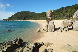
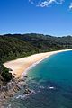
The Abel Tasman Coast Track is a 60 kilometres (37 mi) long walking track within the Abel Tasman National Park in New Zealand. It extends from Mārahau in the south to Wainui in the north, with many side tracks. It is one of two main tracks through the park, the other being the Abel Tasman Inland Track, which stretches for 38 km between Tinline Bay and Torrent Bay off the main coastal track. The coastal track is well sheltered, and with mild weather in all seasons, it is accessible and open throughout the year.

<span class="mw-page-title-main">Abel Tasman Inland Track</span> Hiking trail in New Zealand

The Abel Tasman Inland Track is a 38 km tramping track that runs through the centre of the Abel Tasman National Park and is maintained by the Department of Conservation. It diverts from the main Abel Tasman Coast Track between Tinline Bay and Torrent Bay. Although the coast track has the reputation of being New Zealand's most popular walking track, the inland track is a much less walked route, with regular back-country huts.

<span class="mw-page-title-main">Wainui River (Tasman)</span> River in New Zealand

The Wainui River is a river of the Tasman Region of New Zealand's South Island. Wainui is a Māori language term and the umbrella entity for the three local iwi gives a meaning of "where the tidal flow leaves a big expanse of bay empty".

<span class="mw-page-title-main">Golden Bay / Mohua</span> Bay in New Zealand

Golden Bay is a large shallow bay in New Zealand's Tasman District, near the northern tip of the South Island. An arm of the Tasman Sea, the bay lies northwest of Tasman Bay and Cook Strait. It is protected in the north by Farewell Spit, a 26 km long arm of fine golden sand that is the country's longest sandspit. The Aorere and Tākaka rivers are the major waterways to flow into the bay from the south and the west.

<span class="mw-page-title-main">Tonga Island</span> Island in New Zealand

Tonga Island is a small (0.15 km2) island in Tasman Bay / Te Tai-o-Aorere, off the northern coast of the South Island of New Zealand. It lies within the Abel Tasman National Park, about 1 kilometre (0.62 mi) off Onetahuti Beach. The island has a flourishing fur seal colony, and is surrounded by the Tonga Island Marine Reserve, which was inaugurated in 1993.

<span class="mw-page-title-main">Rawhiti Cave</span>

Rawhiti Cave, also known as Manson Cave, is a single large limestone cave in the hillside of the Dry Creek Valley 7 kilometres (4.3 mi) southeast of Tākaka on the South Island of New Zealand. It is referred to as Manson Cave in the NZ Topo Map, after owners in the early 20th century, however the cave is known as Rawhiti Cave locally, and on DoC information panels and in brochures.

<span class="mw-page-title-main">Wainui Falls</span> Waterfall in Tasman, New Zealand

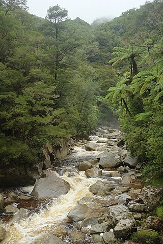
Wainui Falls is a 20-metre (66 ft) waterfall in Wainui Bay, in the Tasman region of New Zealand. The waterfall is part of the Wainui River and cascades over granite bedrock into a deep pool at its base. It is the largest and most accessible waterfall in the Abel Tasman National Park and the Nelson-Golden Bay area, and can be reached via the short Wainui Falls Track. The track is popular as a day walk among tourists, and while the waters of the Wainui River can be too cold for swimming much of the year, the plunge pool is a favoured swimming hole in the summer months.

<span class="mw-page-title-main">Wainui Bay</span> Bay in Tasman Region, New Zealand

Wainui Bay is within Golden Bay / Mohua, and at the south-eastern end of Golden Bay, in the Tasman Region of the South Island, New Zealand.

<span class="mw-page-title-main">Abel Tasman Monument</span> Monument in New Zealand

The Abel Tasman Monument is a memorial to the first recorded contact between Europeans—led by the Dutch explorer Abel Tasman—and Māori in New Zealand's Golden Bay on 18 and 19 December 1642. It was unveiled on the tercentenary of the encounter by the prime minister, several government ministers, and a Dutch delegation. The monument, originally referred to as the Abel Tasman Memorial, was designed by the architect Ernst Plischke as an abstracted sail, and consists of a large concrete monolith painted white. Located on a bluff at Tarakohe just east of Pōhara, the land for the monument was gifted by the Golden Bay Cement Company. The dignitaries opened the Abel Tasman National Park the following day and the area holding the monument is part of the national park. As was typical for the 1940s, the original inscription focused on the European experience only and overlooked the Māori perspective, demonstrating Western-centric systemic bias. The monument is one of New Zealand's National Memorials.

<span class="mw-page-title-main">Awapoto River</span> River in New Zealand

The Awapoto River, also known as Little River as a literal translation from Māori, is a river in the Tasman District of New Zealand. It rises east of Evans Ridge. There are no named peaks near the source, but the Abel Tasman Inland Track follows Evans Ridge near the river's source. The Awapoto River initially flows north-east and then east through the Abel Tasman National Park. It flows through Hadfield Clearing and then passes under Awaroa Road before entering the Awaroa Inlet.

<span class="mw-page-title-main">Awaroa Inlet</span> Inlet in Tasman Region, New Zealand

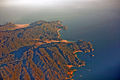
Awaroa Inlet is a remote, alluring body of water within the Abel Tasman National Park, at the northern end of Tasman Bay, in the Tasman Region of the South Island, New Zealand.

References

  1. 1 2 3 Hoiberg, Dale H., ed. (2010). "Abel Tasman National Park" . Encyclopædia Britannica. Vol. I: A-ak Bayes (15th ed.). Chicago, Illinois: Encyclopædia Britannica Inc. pp.  25. ISBN   978-1-59339-837-8.
  2. 1 2 "Abel Tasman National Park Management Plan" (PDF). Nelson/Marlborough Conservancy Factsheet 173, New Zealand Government. November 2008.
  3. "Abel Tasman Coast Track". www.doc.govt.nz. Retrieved 13 January 2024.
  4. 1 2 3 4 "Abel Tasman National Park". Department of Conservation, Te Papa Atawhai.
  5. Reid, Darren. "Muaūpoko". The Encyclopedia of New Zealand: teara.govt.nz.
  6. Smith, Dawn (May 1997). Abel Tasman Area History (PDF). Nelson: Department of Conservation: Te Papa Atawhai. ISBN   0-478-01905-X.
  7. Taonga, New Zealand Ministry for Culture and Heritage Te Manatu. "Moncrieff, Pérrine" . Retrieved 20 December 2016.
  8. 1 2 Historic Event, Evening Post, Wellington| volume=CXXXIV| issue=127, 25 November 1942, Page 3
  9. Tasman Tercentenary, Evening Post| volume=CXXXIV| issue=144, 15 December 1942, Page 4
  10. 1 2 Memory of Tasman A new National Park, Evening Post| volume=CXXXIV| issue=147, 18 December 1942, Page 4
  11. Appendix to the Journals of the House of Representatives, 1949 Session I, C-10 Page 4
  12. "National Parks gain ground". press release. New Zealand Government. 20 March 2008. Archived from the original on 17 October 2008. Retrieved 26 March 2008.
  13. "Data Table – Protected Areas – LINZ Data Service". Land Information New Zealand . Retrieved 18 October 2017.
  14. Abel Tasman National Park Management Plan (PDF). Department of Conservation – Te Papa Atawhai. 2008–2018.
  15. "Abel Tasman National Park | Coastal Walks, Kayaking, Wildlife | Britannica". www.britannica.com. Retrieved 5 January 2024.
  16. "Wainui Falls Track". doc.govt.nz. Retrieved 9 January 2018.
  17. "Abel Tasman National Park Village – New Zealand" . Retrieved 20 December 2016.
  18. "Abel Tasman National Park Management Plan". www.doc.govt.nz. Retrieved 5 January 2024.
  19. "janszoon.org". Archived from the original on 9 August 2018. Retrieved 22 February 2015.

Wikivoyage-Logo-v3-icon.svg Abel Tasman National Park travel guide from Wikivoyage