
A wildlife management area (WMA) is a protected area set aside for the conservation of wildlife and for recreational activities involving wildlife.
A wildlife management area (WMA) is a protected area set aside for the conservation of wildlife and for recreational activities involving wildlife.
There are 11 wildlife management areas in New Zealand: [1]
In Papua New Guinea a Wildlife Management Area is the simplest form of protected area. A WMA designation protects an area of land or water while retaining full power to landowners to manage their land. WMAs are managed by an elected committee formed of customary landowners. [2]
The current Wildlife Management Areas are:
The Community Wildlife Management Areas Consortium (CWMAC) is an umbrella organization for all other organizations in Tanzania. [3] As of 2016 there are 22 WMAs that have received "Authorized Association" (AA) status out of a total of 38 that have been established or gazetted. WMAs include:
In the United States, WMAs exist in these states:

Tanzania comprises many lakes, national parks, and Africa's highest point, Mount Kilimanjaro. Northeast Tanzania is mountainous, while the central area is part of a large plateau covered in grasslands. The country also contains the southern portion of Lake Victoria on its northern border with Uganda and Kenya.

Kagera Region is one of Tanzania's 31 administrative regions. The region covers an area of 35,686 km2 (13,778 sq mi). The region is comparable in size to the land area of the Netherlands. Kagera Region is bordered to the east by Lake Victoria, Mwanza Region and Mara Region. The region is bordered to the south by Geita Region and Kigoma Region. Lastly, Kagera borders Rwanda to the west, Uganda to the north and Burundi to the south west. The regional capital city is Bukoba. According to the 2022 national census, the region had a population of 2,989,299, an increase from 2,458,023 recorded in 2012.

Lindi Region is one of Tanzania's 31 administrative regions. The region covers an area of 66,040 km2 (25,500 sq mi). The region is comparable in size to the combined land area of the nation state of Sri Lanka. The regional capital is the municipality of Lindi.
The Burunge or Burungi are a Cushitic ethnic group and among Iraqhw Communities based in the Chemba District of Dodoma Region in central Tanzania. They speak the Burunge language as a mother tongue, which belongs to the South Cushitic branch of the Afro-Asiatic family. In 2007, the Burunge population was estimated at 30,000 individuals.

Mount Bosavi is a mountain in the Southern Highlands province, Papua New Guinea. It is the collapsed cone of an extinct volcano on the Great Papuan Plateau, part of the Kikori River basin. The crater is approximately 4 km wide and 1 km deep; it is home to a number of endemic species.

The wildlife of Cameroon is composed of its flora and fauna. Bordering Nigeria, it is considered one of the wettest parts of Africa and records Africa's second highest concentration of biodiversity. To preserve its wildlife, Cameroon has more than 20 protected reserves comprising national parks, zoos, forest reserves and sanctuaries. The protected areas were first created in the northern region under the colonial administration in 1932; the first two reserves established were Mozogo Gokoro Reserve and the Bénoué Reserve, which was followed by the Waza Reserve on 24 March 1934. The coverage of reserves was initially about 4 percent of the country's area, rising to 12 percent; the administration proposes to cover 30 percent of the land area.

The Eastern miombo woodlands (AT0706) are an ecoregion of grassland and woodland in northern Mozambique, southern Tanzania, and southeastern Malawi.
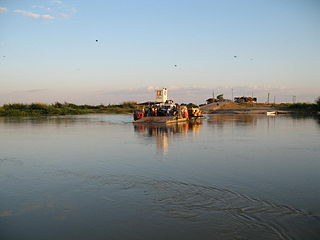
The Ulanga River, also known as the Kilombero River, rises in the highlands of the southwest of Morogoro Region, Tanzania, on the eastern slope of the East African Rift. The river flows northeast along the northeastern border of the Lindi Region before it flows into the Rufiji River. The Rufiji eventually flows into the Indian Ocean on the southern coast of the Pwani Region.

Tanzania contains some 20 percent of the species of Africa's large mammal population, found across its reserves, conservation areas, marine parks, and 17 national parks, spread over an area of more than 42,000 square kilometres (16,000 sq mi) and forming approximately 38 percent of the country's territory. Wildlife resources of Tanzania are described as "without parallel in Africa" and "the prime game viewing country". Serengeti National Park, the country's second largest national park area at 14,763 square kilometres (5,700 sq mi), is located in northern Tanzania and is famous for its extensive migratory herds of wildebeests and zebra while also having the reputation as one of the great natural wonders of the world. The Ngorongoro Conservation Area, established in 1959, is a UNESCO World Heritage Site and inhabited by the Maasai people. Its Ngorongoro Crater is the largest intact caldera in the world.
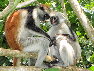
The wildlife of Zanzibar consists of terrestrial and marine flora and fauna in the archipelago of Zanzibar, an autonomous region of Tanzania. Its floral vegetation is categorized among the coastal forests of eastern Africa as the Southern Zanzibar-Inhambane coastal forest mosaic and the Northern Zanzibar-Inhambane coastal forest mosaic. Its faunal species are mostly small animals, birds, and butterflies.

Lake Jipe is an inter-territorial lake straddling the borders of Kenya and Tanzania. On the Kenyan side, it is located south of the village of Nghonji while on the Tanzanian side, it is situated within Mwanga District, in Kilimanjaro Region. The lake is fed mainly by the Lumi River, which descends from Mount Kilimanjaro, as well as streams from the North Pare Mountains, being on the leeward side. The lake's outlet forms the Ruvu River. Kenya's unfenced Tsavo West National Park protects part of the lake's northern shore, while on the Tanzania side Mkomazi Game Reserve is nearby. The lake is known for its endemic fish, as well as water birds, mammals, wetland plants and lake-edge swamps, which can extend 2 kilometres (1.2 mi) from Jipe's shore.

The Pangani River, is a major river of northeastern Tanzania. It has two main sources: the Ruvu, which rises as Lumi at Kilimanjaro, passes through Lake Jipe, and empties into the Nyumba ya Mungu Reservoir, and the Kikuletwa River, coming from the west and mainly fed by rivers of Mount Meru in Arusha Region, which also enters into the Nyumba ya Mungu Reservoir in Kilimanjaro Region. Just after leaving the reservoir the stream becomes the main Pangani, which empties into the Indian Ocean in Tanga Region at the Tangan port town of Pangani.

Ulanga District is one of the six districts of the Morogoro Region of Tanzania. the administrative seat is in Mahenge. It covers 24,460 square kilometres (9,444 sq mi) of which 4,927 square kilometres (1,902 sq mi) is in forest reserves. Ulanga District is bordered to the north and west by the Kilombero District, to the east by the Lindi Region and to the south by the Ruvuma Region.
The Tanzania National Parks Authority commonly known as TANAPA is responsible for the management of Tanzania's national parks. TANAPA is a parastatal corporation and all its income is reinvested into the organization. It is governed by a number of instruments including the National Parks Act, Chapter 282 of the 2002 and the Wildlife Conservation Act No. 5 of 2009. TANAPA manages the nation's 23 National parks which covers approximately 15% of the land area and has the mandate to conserve and manage the wildlife in Tanzania, and to enforce the related laws and regulations in this industry. It manages the biodiversity of the country, protecting and conserving the flora and fauna. The organization does not have a mandate over the game reserves such as the Selous Game Reserve which is managed by the Tanzanian Wildlife Division and the Ngorongoro Conservation Area managed by the Ngorongoro Conservation Authority.

Many areas of Vietnam are under protection. While the national reserves cover small areas of scientific significance with restricted access, the national parks also cover wetlands of Ramsar designated areas and BirdLife International inscribed bird areas. The largest of the national parks initially covered were the Cúc Phương National Park, the Cát Tiên National Park, and the Côn Đảo National Park which to start with were forest areas cum reserves or prohibited areas. The objective for creating national parks was to allow access to the reserved areas as a part of ecotourism and cultural needs with full attention to the basic approach of conservation of natural environmental resources.

Virginia Wildlife Management Areas (WMAs) are state-managed protected areas that exist primarily for the benefit of wildlife. Within the Commonwealth of Virginia, 46 tracts of land have been protected as WMAs, covering a total of over 216,000 acres. They are managed and maintained by the Virginia Department of Wildlife Resources.
Julius Nyerere Hydropower Station is a hydroelectric dam under construction and partially operational across the Rufiji River in eastern Tanzania. Although controversial, the government approved the plans in 2018. The power station is expected to have an installed capacity of 2,115 megawatts (2,836,000 hp) and to produce 5,920 GWh of power annually. As of July 2024, three of the nine turbines have been turned on, generating 662 megawatts. The project, power station and dam are owned by and will be managed by the government owned Tanzania Electric Supply Company (TANESCO). Construction began in 2019 and is expected to be completed by the end of 2024.

Nyerere National Park is the largest national park in Tanzania and also one of the world's largest wildlife sanctuaries and national parks. The total area of the park is 30,893 km2 (11,928 sq mi) and covers the big part of Liwale District in western Lindi Region, south west Pwani Region, north eastern Ruvuma Region and a big part of south eastern Morogoro Region. The park is about the size of Belgium (Europe). Much of the area is in a wild state without being altered by human activities. The part of Selous game reserve is now running a hydro electric power. The park has a great river known as Rufiji River. Rufiji is Tanzania's largest river and is home to many crocodiles and hippopotamuses. It is also one of largest mangrove forests in the world located at its delta.
| International | |
|---|---|
| National | |