Paparoa National Park

Last updated

Paparoa National Park
2019-01-10 105850 Pancake Rocks anagoria.jpg
Pancake Rocks
Paparoa National Park
Interactive map of Paparoa National Park
Location West Coast, New Zealand
Coordinates 42°5′S171°30′E / 42.083°S 171.500°E / -42.083; 171.500
Area429.7 km2 (165.9 sq mi)
Established1 January 1987
Governing body Department of Conservation

Paparoa National Park is on the west coast of the South Island of New Zealand.

Contents

Paparoa National Park Visitor Centre (2021) Paparoa VC 27.jpg
Paparoa National Park Visitor Centre (2021)

The park was established in 1987 and encompasses 430 km2 (166 sq mi). [1] The park ranges from or near the coastline to the peaks of the Paparoa Range. A separate section of the park lies to the north and is centred at Ananui Creek. The park protects a limestone karst area. The park contains several caves, of which Metro Cave / Te Ananui Cave is a commercial tourist attraction. The majority of the park is forested with a wide variety of vegetation. The park was the site of the 1995 Cave Creek disaster where fourteen people died as a result of the collapse of a scenic viewing platform.

The Paparoa Track, one of New Zealand's Great Walks, runs through the park. [2]

The small settlement of Punakaiki, adjacent to the Pancake Rocks and Blowholes tourist attraction, lies on the edge of the park. The park is also located near the towns of Westport, Greymouth and Barrytown.

History

Park establishment

In 1976, the Federated Mountain Clubs had identified the northern part of the Paparoa Ranges as a potential wilderness area. In 1979, the Native Forest Action Council proposed a 130,000 hectare national park, including the northern Paparoa Ranges and land to the north and east. This eventually led to the National Parks and Reserves Authority identifying the western Paparoa Range as a prospective national park. Meanwhile, a joint proposal by the Department of Scientific and Industrial Research and the National Museum succeeded in having a core area of great ecological significance – the forests of the lowland karst syncline – gazetted as the Pororari Ecological Area in 1979.

The initial proposal for a large park incorporating the wilderness area was rejected, but after seven rounds of submissions and help from other environment groups including the Royal Forest and Bird Protection Society, an area of 30,327 hectares was gazetted as Paparoa National Park on 23 November 1987. [3]

Expansion

Following the liquidation of Pike River Coal, Solid Energy purchased the assets of the company. [4] The government then purchased the 3,580 hectares (8,800 acres) of land around the Pike River Mine. The environment minister, Nick Smith, announced on 15 November 2015 that the 3,580 ha of land was to be added to the Park. [5]

Geography

Location

Paparoa National Park is located in the northern West Coast region of the South Island, between the Buller River (Kawatiri) and the Grey River (Māwheranui). It includes the western side of the Paparoa Range and some separate eastern sections along the Inangahua River. The park covers the catchment areas of the Punakaiki, Pororari and Fox (Potikohua) rivers and Bullock Creek (Punungairo), and also the Metro / Te Ananui cave system and the southern side of the Tiropahi River catchment. [6]

Geology

Landforms

The park has unusually diverse geology with a wide variety of coastal, lowland and mountain landforms. The major geological structures that form the park are the Barrytown syncline, the Punakaiki anticline, the Paparoa Tectonic Zone, the Cape Foulwind fault and the Hawera fault. [3] Most of the land area of the park is mountainous. The eastern side of the main range has deep glaciated valleys that run north and south, with towering bluffs and cirques, hanging valleys, and truncated spurs. The western coastline is known for its spectacular and varied scenery and its accessibility. [3]

Mountains

The Paparoa mountains were uplifted during the late Pliocene or early Quaternary periods. Mt Lodge, the highest mountain in the park at 1,447 metres (4,747 ft), has rocks that are the oldest in New Zealand. [3] Over the last 10 million years, the movement of the Alpine Fault has separated the predominantly granite and gneiss rocks of the Paparoas from their original neighbours, so that they now more closely resemble the rocks in Fiordland, far to the southwest, than to the relatively nearby main range of the Southern Alps. [7]

Karst

Cave Creek resurgence Cave Creek resurgence.jpg
Cave Creek resurgence
Pororari River Track Paparoa 28.jpg
Pororari River Track

Rivers flowing from the Paparoa Ranges pass through the limestone syncline, creating subterranean waterways and extensive cave systems that are one of the features of the park. [3] The main rivers are the Fox, Pororari and Punakaiki. Another of the rivers is Cave Creek, site of the 1995 Cave Creek disaster. Cave Creek is fed by a complex cave system.

Upstream of the Xanadu and Taurus Major sinkholes, on Bullock Creek (the most northerly on the west coast, [8] others being near Ross [9] and Fox Glacier [10] ), a polje of up to about 1 km (0.62 mi) [11] square and 1 m (3 ft 3 in) deep can form after heavy rain. Bush felling and drainage took place in the polje from the 1870s, but the wetland ecology has been undergoing restoration since 1986. [12] The other large polje in this country is at Lake Disappear in Waikato.

The river gorges, confined by high, forest-crowned limestone cliffs, provide a means of access to the park's karst interior. However, in many of the tributaries the gorges are narrow, steep and include waterfalls. Dry, mossy streambeds, karren, [13] sinkholes (or dolines), [14] blind valleys and basins where water emerges from caves or vanishes into sinks are all indicators of the complex subterranean system beneath. Intricate systems of shafts, passages and caverns have been slowly formed by the continual effects of water through the soluble limestone. The forest ensures that this process continues by supplying decaying vegetation to add to the acidity in the flowing water. The largest single feature in the karst region is the Barrytown syncline. Limestone is exposed on both flanks of the syncline with more recent gravels and mudstones occupying the low-lying area in between. These more easily erodible rocks overlie interstratal karst. The majority of known cave systems are in the western side of the limestone syncline where underground drainage patterns are concentrated mainly along horizontal lines of weakness in the bedding planes. [15]

Coastal region

The "Pancake Rocks" at Paparoa National Park Pancake Rocks, Punakaiki.jpg
The "Pancake Rocks" at Paparoa National Park
Fox River- Paparoa National Park Fox River- Paparoa National Park, New Zealand.jpg
Fox River- Paparoa National Park

The Paparoa coastline is characterised by high cliffs cut away by waves from the Tasman Sea, with indented coves and sandy beaches. There are small islands offshore and rock pillars. These terraces were once islands, which became part of the mainland when New Zealand was uplifted quite recently in its geological history. The most well known feature of the coastal region is the Pancake Rocks and Blowholes at Dolomite Point, near Punakaiki, where evenly layered stacks of platey limestone have been eroded in places to form surge pools and blowholes. [15]

Ecology

Fauna

Bird habitats within the park range from on or near the coastline to the peak of the Paparoa Ranges. Several species such as tūī, bellbird, kākā, kererū (New Zealand pigeon) and parakeets migrate from winter habitat in the lower forests to summer habitat in the upland forests. [16]

A significant feature of the coast is the colony of the rare seabird, the Westland petrel (tāiko), that is located on densely forested terraces just south of Punakaiki river. [17] The Westland petrel breeding site at Punakaiki has been identified as an Important Bird Area by BirdLife International. [18]

Large colonies of New Zealand fur seals have been established adjacent areas around Westport such as at Cape Foulwind. Rare southern elephant seals and leopard seals also visit. [19] Hector's dolphins (some of the highest population densities in the nation) and some other dolphins including killer whales can be observed close to shores as well. [20] [21] [22] For whales, their number is still very small, but various species have been observed. [23]

Conservation and human interaction

Protection from mining

Although Paparoa National Park is protected from mining by Schedule 4 of the Crown Minerals Act, there have been proposals to allow some mining within the park's borders. On 22 March 2010, Gerry Brownlee (Minister of Energy and Resources) and Kate Wilkinson (Minister of Conservation) released a discussion paper including a proposal to remove 7,058 hectares of land from Schedule Four of the Crown Minerals Act 1991, including the Inangahua sector of Paparoa National Park. [24] The area of the Inangahua sector included in this proposal was 3,315 hectares, or 8 per cent of the park. [25] The proposed change would remove the prohibition on mining for the area concerned. On 26 March 2010, a spokesman for Gerry Brownlee said that opencast mining in Paparoa National Park could not be ruled out. [26]

On 20 July 2010, in a joint statement by Brownlee and Wilkinson, the Government announced that it had received 37,552 submissions on its discussion paper, and that it had decided not to remove any land from Schedule 4 of the Crown Minerals Act for the purposes of further mineral exploration or extraction. Ms Wilkinson said the government had agreed to continue with its proposal to add 14 areas with a total of 12,400 hectares of land to Schedule 4, including 240 hectares of Paparoa National Park (the northwest addition). [27]

Activities

The park is a popular location for tramping, walking, and viewing scenery and caves. The Truman Track, located 3 kilometres (1.9 mi) north of Punakaiki, provides access from State Highway 6 to a headland via a short walk through coastal forest of ferns, nīkau palms, podocarps and rātā, with flax nearer the coastline. [28] The Paparoa Track is another popular route.

Paparoa Track and Pike29 Memorial Track

A 55 km (34 mi) walkway, the Paparoa Track from Blackball to Punakaiki and the Pike29 Memorial Track were constructed through the park as a memorial to the 29 miners lost in the 2010 Pike River Mine disaster. Most of the families of the victims approved, [29] [30] but there has been some criticism because Solid Energy decided in 2014 that it was too risky to re-enter the mine to recover any remains from the mine. [31]

Paparoa Track (Pororari river) Paparoa 27.jpg
Paparoa Track (Pororari river)

The formation of the Paparoa Track has been a catalyst for the emerging adventure sports community on the West Coast with events such as The Paparoa [32] which features trail running and mountain biking over the track. The event is based around the regions mining history and also celebrates the number of exceptional female adventure athletes the region has produced such as Casey Brown, Ruth Croft and Emily Miazga.

See also

Related Research Articles

<span class="mw-page-title-main">Leeuwin-Naturaliste National Park</span> Protected area in Western Australia

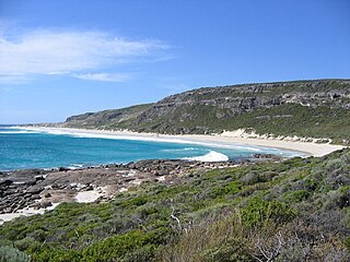
Leeuwin-Naturaliste National Park is a national park in the South West region of Western Australia, 267 km (166 mi) south of Perth. It is named after the two locations at either end of the park which have lighthouses, Cape Leeuwin and Cape Naturaliste. It is located in the Augusta-Margaret River and Busselton council areas, and is claimed to have the highest visiting numbers of any national park in Western Australia. The park received 2.33 million visitors through 2008–2009.

<span class="mw-page-title-main">Kahurangi National Park</span> National park in New Zealand

Kahurangi National Park in the northwest of the South Island of New Zealand is the second largest of the thirteen national parks of New Zealand. It was gazetted in 1996 and covers 5,193 km2 (2,005 sq mi), ranging from the Buller River near Murchison in the south, to the base of Farewell Spit in Golden Bay in the north. The park has no single dominant landform, but includes an unusually wide variety of landscapes, including mountain ranges, rivers, gorges, raised peneplains and karst features such as caves and arches. Many of the landforms within the park are considered to be nationally or internationally significant.

<span class="mw-page-title-main">Punakaiki</span> Place in West Coast, New Zealand

Punakaiki is a small village on the West Coast of the South Island of New Zealand. It is located between Westport and Greymouth on State Highway 6, the only through-road on the West Coast. Punakaiki is immediately adjacent to Paparoa National Park, and is also the access point for a popular visitor attraction, the Pancake Rocks and Blowholes.

<span class="mw-page-title-main">Westland petrel</span> Species of bird

The Westland petrel(Procellaria westlandica),, also known as the Westland black petrel, is a moderately large seabird in the petrel family Procellariidae, that is endemic to New Zealand. Described by Robert Falla in 1946, it is a stocky bird weighing approximately 1,100 grams (39 oz), and is one of the largest of the burrowing petrels. It is a dark blackish-brown colour with black legs and feet. It has a pale yellow bill with a dark tip.

<span class="mw-page-title-main">Paparoa Range</span> Mountain range in New Zealand

The Paparoa Range is a mountain range in the West Coast region of New Zealand's South Island. It was the first New Zealand land seen by a European – Abel Tasman in 1642. Part of the range has the country's highest protection as a national park; the Paparoa National Park was established in 1987. Within that park, the Cave Creek disaster occurred in 1995.

<span class="mw-page-title-main">Pororari River</span> River in New Zealand

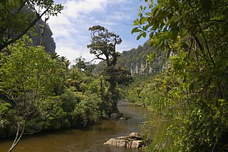
The Pororari River, with an older spelling of Porarari, is a river of the West Coast Region of New Zealand's South Island. It flows northwest from its sources in the Paparoa Range, reaching the Tasman Sea at Punakaiki via Pororari Lagoon. Cave Creek / Kotihotiho is a tributary to the river. There are opportunities to tramp along this river, with two different options accommodating multi-hour loop walks. Further upstream, the Pororari River is followed by the new Paparoa Track, which provides an opportunity for multi-day tramping or mountain biking.

<span class="mw-page-title-main">Punakaiki River</span> River in New Zealand

The Punakaiki River is a river of the West Coast Region of New Zealand's South Island. It flows predominantly northwest from its sources in the Paparoa Range, reaching the Tasman Sea two kilometres south of the town of Punakaiki. Most of the river's length is within Paparoa National Park.

<span class="mw-page-title-main">Fox River (Buller)</span> River in New Zealand

The Fox River is a river in the Buller District of New Zealand. It arises in the Paparoa Range near Mount Dewar and flows north-west through the Paparoa National Park to the Tasman Sea at Woodpecker Bay. The river passes through a spectacular gorge. The northern branch of the river has limestone caves containing stalactite and stalagmite formations.

<span class="mw-page-title-main">Nelson Coast temperate forests</span> Ecoregion in New Zealand

The Nelson Coast temperate forests is an ecoregion in New Zealand.

<span class="mw-page-title-main">Metro Cave / Te Ananui Cave</span>

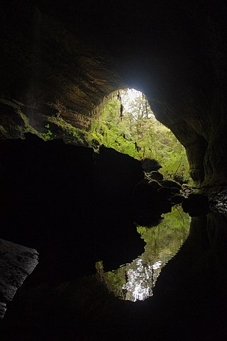
The Metro / Te Ananui Caves are a maze of limestone caves formed by the underground capture of Ananui Creek, a tributary of the Waitakere / Nile River. The caves are located in the Paparoa National Park in New Zealand, managed by the Department of Conservation. Parts of the cave system are accessible by cave tours and rafting, operated by a commercial tour operator out of Charleston.

<span class="mw-page-title-main">Paparoa Track</span> Hiking and mountain biking track in New Zealand

The Paparoa Track is a 55.7 km (34.6 mi) shared hiking and mountain biking track located in Paparoa National Park in the South Island of New Zealand. The track was created as a memorial for the 29 miners who lost their lives in the Pike River Mine disaster. The track is the tenth Great Walk to be created and has been fully open since 1 March 2020. It was the first addition to the Great Walks in 25 years.

<span class="mw-page-title-main">Cave Creek / Kotihotiho</span> River in West Coast, New Zealand

Cave Creek / Kotihotiho is a small river within Paparoa National Park, on the West Coast of New Zealand's South Island.

<span class="mw-page-title-main">Punakaiki Marine Reserve</span>

Punakaiki Marine Reserve is a marine reserve administered by the Department of Conservation. The reserve includes the area of sea surrounding the pancake rocks and blowholes at Dolomite Point, at Punakaiki on the West Coast Region of New Zealand's South Island. It also includes most of the coastline on the western edge of Paparoa National Park.

<span class="mw-page-title-main">Ballroom Overhang</span> Limestone outcrop in New Zealand

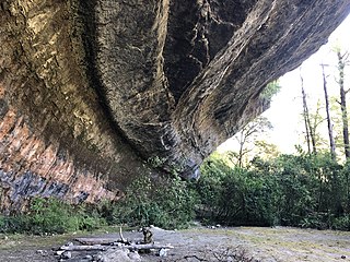
The Ballroom Overhang is a large limestone outcrop on the Fox River in Paparoa National Park, in the Buller District of New Zealand. The Ballroom Overhang provides a sheltered place for resting or overnight camping. The overhang is 10 m (33 ft) at its highest point, 100 m (330 ft) long, and 30 m (98 ft) at its widest point.

<span class="mw-page-title-main">Pancake Rocks and Blowholes</span> Coastal rock formation in New Zealand

The Pancake Rocks and Blowholes are a coastal rock formation at Punakaiki on the West Coast of the South Island of New Zealand. They are a popular visitor attraction.

<span class="mw-page-title-main">Bullock Creek (New Zealand)</span> Creek in New Zealand

Bullock Creek or Punungairo is a river valley in the Paparoa National Park, located just north of Punakaiki on the West Coast of New Zealand. It includes a rare and nationally significant polje, a large, flat-floored depression within karst limestone. The Bullock Creek polje is New Zealand's only example of this type of landform.

<span class="mw-page-title-main">Inland Pack Track</span> New Zealand tramping track

The Inland Pack Track is a trail in the Paparoa National Park on West Coast of New Zealand. The full length of the trail commences at the Punakaiki River in the south, and ends at the mouth of the Fox River in the north. It takes two or three days to complete the track.

<span class="mw-page-title-main">Pike29 Memorial Track</span>

The Pike29 Memorial Track is a hiking track located in Paparoa National Park in the South Island of New Zealand. The track is being created as a memorial for the 29 miners who lost lives in the Pike River Mine disaster. The track is part of the Paparoa Track, the tenth Great Walk created. Both tracks were originally scheduled to open in 2018. Whilst the Paparoa Track has been fully open since March 2020, the Pike29 Memorial Track is still under construction and expected to open in December 2022. A memorial and interpretation centre at the Pike River Mine portal is due to be finished in April 2024.

<span class="mw-page-title-main">Waitakere / Nile River</span> River in New Zealand

The Waitakere / Nile River is a river on the West Coast of New Zealand's South Island. It rises in the Paparoa Range and flows through a limestome karst landscape in a roughly northwest direction for its entire length, reaching the Tasman Sea just north of Charleston. The river and its surrounds are a popular tourist destination, particularly for a bush train along the river's canyon and caving through the nearby Metro / Te Ananui Caves. The lower reaches of the river are also a popular fishing spot, particularly for brown trout.

References

  1. "Data Table – Protected Areas – LINZ Data Service". Land Information New Zealand. Archived from the original on 18 October 2017. Retrieved 18 October 2017.
  2. "Great Walks". Department of Conservation. Archived from the original on 1 April 2020. Retrieved 28 March 2020.
  3. 1 2 3 4 5 Paparoa National Park Resource Summary (PDF). Department of Conservation. 1990. ISBN   0-478-01193-8. Archived (PDF) from the original on 22 March 2022. Retrieved 8 January 2012.
  4. "Pike River mine sold to Solid Energy". Stuff . 3 December 2015. Archived from the original on 4 March 2016. Retrieved 5 December 2015.
  5. "Pike River walkway confirmed for West Coast". Stuff . 15 November 2015. Archived from the original on 11 September 2017. Retrieved 9 July 2022.
  6. "Paparoa National Park Management Plan" (PDF). Department of Conservation. 2017. p. 22. Retrieved 3 July 2022.
  7. Paparoa National Park Management Plan (PDF). Department of Conservation. 1992. ISBN   0-478-01468-6. Archived (PDF) from the original on 22 March 2022. Retrieved 8 January 2012.
  8. "Bullock Creek, West Coast". NZ Topo Map. Archived from the original on 24 November 2021. Retrieved 24 November 2021.
  9. "Bullock Creek, West Coast". NZ Topo Map. Archived from the original on 24 November 2021. Retrieved 24 November 2021.
  10. "Bullock Creek, West Coast". NZ Topo Map. Archived from the original on 24 November 2021. Retrieved 24 November 2021.
  11. Paul W Williams (2005). "Karst Evolution on the West Coast" (PDF). Archived (PDF) from the original on 24 November 2021. Retrieved 24 November 2021.
  12. Sorrell, Brian (28 February 2007). "Freshwater feature: the Bullock Creek polje". NIWA. Archived from the original on 24 November 2021. Retrieved 24 November 2021.
  13. "Karst Geology: Karren". www.showcaves.com. 2011. Archived from the original on 15 December 2011. Retrieved 10 January 2012.
  14. "Karst Geology: Doline or sink hole". www.showcaves.com. 2011. Archived from the original on 7 June 2020. Retrieved 10 January 2012.
  15. 1 2 Paparoa National Park Management Plan (PDF). Department of Conservation. 1992. ISBN   0-478-01468-6. Archived (PDF) from the original on 22 March 2022. Retrieved 8 January 2012.
  16. "Birding sites – Paparoa National Park". New Zealand Birds Limited. Archived from the original on 28 March 2020. Retrieved 28 March 2020.
  17. "Westland petrel – tāiko" (PDF). Department of Conservation. 2006. Archived from the original (PDF) on 19 May 2010. Retrieved 8 January 2012.
  18. BirdLife International. (2012). Important Bird Areas factsheet: Punakaiki. Downloaded from http://www.birdlife.org Archived 10 July 2007 at the Wayback Machine on 16 February 2012.
  19. "Leopard seal encounter New Zealand". YouTube . Archived from the original on 5 December 2021.
  20. "North Beach, South Island, New Zealand, Buller, Westport". Archived from the original on 11 April 2016. Retrieved 6 May 2014.
  21. http://www.epa.govt.nz/Publications/STOS_Ruru_2_and_Maui_Appendix_5_PART%20_C_Reduced.pdf Archived 4 March 2016 at the Wayback Machine .
  22. "Near-shore distribution and abundance of dolphins along the West Coast of the South Island, New Zealand – ResearchGate". Archived from the original on 15 May 2014.
  23. "West Coast Marine Protection Forum". Archived from the original on 19 December 2010. Retrieved 6 May 2014.
  24. "Time to discuss maximising our mineral potential". New Zealand Government. 22 March 2010. Archived from the original on 26 February 2012. Retrieved 11 January 2012.
  25. "Maximising our Mineral Potential – Summary of Government proposals" (PDF). New Zealand Government. 22 March 2010. Archived from the original (PDF) on 24 January 2015. Retrieved 11 January 2012.
  26. "Open cast mining in Paparoa not ruled out". The Press. 26 March 2010. Archived from the original on 29 March 2010. Retrieved 11 January 2012.
  27. "No land to be removed from Schedule 4". New Zealand Government. 20 July 2010. Archived from the original on 26 February 2012. Retrieved 11 January 2012.
  28. "Walks in the Punakaiki area" (PDF). Department of Conservation. December 2020. Retrieved 23 March 2022.
  29. "Pike River tragedy memorial walking track wanted". Stuff . 29 January 2015. Archived from the original on 2 February 2015. Retrieved 9 July 2022.
  30. "Tourist track an insult to dead Pike River miners says widow". Stuff . 15 November 2015. Archived from the original on 9 September 2017. Retrieved 5 December 2015.
  31. "Solid-Energy wont reenter Pike River Mine". Stuff . 6 November 2014. Archived from the original on 13 November 2015. Retrieved 5 December 2015.
  32. "The Paparoa – New Zealand's Premium Mountain Race". Archived from the original on 22 January 2019. Retrieved 28 March 2020.