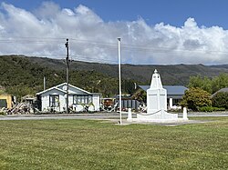
Waimangaroa

Last updated

Waimangaroa
Waimangaroa
Coordinates: 41°42′46″S171°45′46″E / 41.71278°S 171.76278°E / -41.71278; 171.76278 Coordinates: 41°42′46″S171°45′46″E / 41.71278°S 171.76278°E / -41.71278; 171.76278
CountryNew Zealand
Region West Coast
District Buller District
WardSeddon
Electorates West Coast-Tasman
Te Tai Tonga
Area
  Total1.57 km2 (0.61 sq mi)
Population
 (2018) [1]
  Total231
  Density150/km2 (380/sq mi)

Waimangaroa is a small town located on the West Coast of New Zealand.

Contents

The township lies on the south-west bank of the Waimangaroa River, at the western foot of the Denniston Plateau. It is 17 kilometres (11 mi) to the north east of Westport and 13 km south-east of Granity. The abandoned coaltown of Denniston is about 5 kilometres (3.1 mi) to the south-east. [2] [3] The Bridle Track, a scenic bush track, leads south-east along the Denniston Incline into the foothills of the Mt William Range, to Denniston. [4] The Stockton mine, a large open cast coal mine, is operated in the vicinity by Solid Energy. [5]

Waimangaroa viewed from the Denniston road Waimangaroa township.jpg
Waimangaroa viewed from the Denniston road

The Ngakawau Branch, a branch line railway, runs through the town. It opened to Waimangaroa on 5 August 1876; it formerly ran to Seddonville but now terminates in Ngakawau. From 1877 until 1967, Waimangaroa was also the junction for the Conns Creek Branch, which ran east alongside the Waimangaroa River to the foot of the Denniston Incline. Passenger services ceased on the Conns Creek Branch in 1931 and Ngakawau Branch on 14 October 1946. Since this time, the railway through Waimangaroa has almost solely conveyed coal.

The beaches to the west have dangerous currents and are not safe for swimming. [6]

Demographics

Waimangaroa is defined by Statistics New Zealand as a rural settlement and covers 1.57 km2 (0.61 sq mi). It is part of the wider Buller Coalfields statistical area, which covers 498.52 km2 (192.48 sq mi). [7]

The population of Waimangaroa was 231 in the 2018 census, a decrease of 18 from 2013, and an increase of 6 from 2006. There were 123 males and 105 females. 204 people (88.3%) identified as European/Pākehā, 27 (11.7%) as Māori, 3 (1.3%) as Pacific peoples, and 3 (1.3%) as Asian. 48 people (20.8%) were under 15 years old, 18 (7.8%) were 15–29, 105 (45.5%) were 30–64, and 57 (24.7%) were over 65. [1]

Education

Waimangaroa School was a coeducational full primary school (years 1-8). The school celebrated its 125th jubilee in 2004. [8] It closed permanently in 2012 [9] and is now in private ownership. Waimangaroa children now attend schools in Westport.

Notable people

Related Research Articles

Westport, New Zealand Town on the West Coast, New Zealand

Westport is a town in the West Coast region of the South Island of New Zealand. Established in 1861, it is the oldest European settlement on the West Coast. Originally named Buller, it is on the right bank and at the mouth of the Buller River, close by the prominent headland of Cape Foulwind. It is connected via State Highway 6 with Greymouth, 100 kilometres (62 mi) to the south, and with Nelson 222 kilometres (138 mi) in the northeast, via the Buller Gorge. The population of the Westport urban area was 4,280 as of June 2021. The Buller District had a population of 9,660.

Granity Place in West Coast, New Zealand

Granity is a small town on the West Coast of New Zealand's South Island, 28 kilometres (17 mi) north-east of Westport on State Highway 67. Karamea is 68 kilometres (42 mi) further north.

Denniston, New Zealand Place in West Coast, New Zealand

Denniston is a small settlement, 15 kilometres east of Westport, on the West Coast of the South Island of New Zealand. It is situated on the Denniston Plateau, 600 metres (2,000 ft) above sea level in the Papahaua Ranges.

Inangahua Junction Place in West Coast, New Zealand

Inangahua is a small settlement in the northwest of New Zealand's South Island. It consists of three settled areas: Inangahua Junction at the confluence of the Inangahua and Buller Rivers, 34 kilometres (21 mi) north of Reefton and 46 kilometres (29 mi) southeast of Westport; Inagahua Landing, 10 km further up the Inangahua River; and Inangauhua township, 2 km east of the Junction. Murchison is 52 kilometres (32 mi) further east. After the 1968 Inangahua Earthquake, most of the inhabitants left the area or shifted to the township, which is now the population centre and known simply as Inangahua.

Waimangaroa River

The Waimangaroa River is located on the West Coast of New Zealand.

Stillwater–Ngākawau Line

The Stillwater Ngākawau Line (SNL), formerly the Stillwater–Westport Line (SWL) and the Ngakawau Branch, is a secondary main line, part of New Zealand's national rail network. It runs between Stillwater and Ngakawau via Westport on the West Coast of the South Island. It was one of the longest construction projects in New Zealand's history, with its first section opened in 1889 and the full line completed 1942.

The Papahaua Range is a mountain range on the West Coast of New Zealand's South Island east of the town of Westport. It is a geological continuation of the Paparoa Range that is south of the Buller River and it runs north from the Buller Gorge to the Mōkihinui River. At its north end, it meets the Glasgow Range.

Toko Place in Taranaki, New Zealand

Toko is a small rural settlement 10 kilometres east of Stratford, New Zealand, at the intersection of East Road and Toko Road. It is located on a railway, the Stratford–Okahukura Line, the western portion of which was operated as a branch line known as the Toko Branch prior to the line's completion. The Toko Stream flows through the area to join the Pātea River.

Lepperton is a small village in North Taranaki, New Zealand. It is approximately 6 km (3.7 mi) inland from Waitara township, 5 km (3.1 mi) west of the Waitara River, and 1 km (0.62 mi) east of State Highway 3A, which connects Inglewood to Waitara.

Millerton, New Zealand Place in West Coast, New Zealand

Millerton is a small settlement in the northwestern South Island of New Zealand in the West Coast region. It is in the Papahaua Ranges, around 33 kilometres by road north of Westport, via SH67 from Westport to Karamea.


The Seddonville Branch, later truncated as the Ngākawau Branch, is a branch line railway in the West Coast region of New Zealand's South Island. Construction began in 1874 and it reached its terminus at the Mokihinui Mine just beyond Seddonville in 1895. In 1981 it was closed past Ngākawau and effectively became an extension of the Stillwater–Westport Line, since formalised as the Stillwater–Ngākawau Line.

Hector and Ngakawau Place in West Coast, New Zealand

Hector and Ngakawau are two lightly populated settlements located at the mouth of the Ngakawau River in the West Coast region of New Zealand. Both settlements are situated on State Highway 67 between Westport and Karamea. Despite a low population, many of the workers at New Zealand's largest open-cut coal mine at Stockton choose to live at these places and shuttles frequently operate between the two places.

The Conns Creek Branch was a 2.7 kilometre branch line railway in the West Coast region of New Zealand's South Island. It diverged from the Seddonville Branch at Waimangaroa and followed the southern bank of the Waimangaroa River to the line's terminus at Conns Creek at the foot of the Denniston Incline. The line operated from 1877 until 1967 and existed for the sole purpose of conveying coal from mines to the port of Westport.

State Highway 67 (SH 67) is a New Zealand state highway located in the northern parts of the South Island of New Zealand. It is 51.2 km long and connects SH 6 with the settlement of Mokihinui. It used to be 96 kilometres long and ran the entire length of the road to Karamea. The highway and its spur serves the large West Coast town of Westport and lies entirely within the Buller District.

The Ngakawau Hydro Project is a proposed hydroelectric power station planned on the Ngakawau River in the northern section of the West Coast of the South Island of New Zealand. The project is being developed by Hydro Developments Limited.

Stockton Mine

Stockton Mine, on the Stockton Coal Field, is New Zealand's largest opencast mining operation. The entrance to the mine is at the former settlement of Stockton.

Denniston Plateau

Denniston Plateau is an 18 km long, 600–800 m high coalfield plateau in the Papahaua Range on the West Coast of the South Island of New Zealand. A combination of impermeable rock, high rainfall, and shallow acidic soil has created a unique ecosystem of stunted trees and heath-like vegetation which is home to numerous endemic and undescribed species of plants and invertebrates. The plateau contains rich seams of high-quality coal, which led to the creation and abandonment of the mining towns of Denniston and Millerton, and the current Stockton Mine. Plans to create a new open-cast mine on the southern part of the plateau have become an environmental controversy.

Koranui Incline Place in West Coast, New Zealand

The Koranui Incline was an inclined tramway on the West Coast of the South Island of New Zealand that, for four years from late 1882 to the end of 1886, brought coal from a mine high on Mt Frederick down to a railway line near sea level.

Rockies Incline Place in West Coast, New Zealand

The Rockies Incline was an inclined tramway on the West Coast of the South Island of New Zealand that for ten years from 1925 to 1935 brought coal from the Westport Main Coal Company’s mine on the Millerton-Stockton plateau down to the Westport to Seddonville railway line near sea level.

Charming Creek Tramway

The Charming Creek Tramway was a 9 kilometres (5.6 mi) long private bush tramway at Ngakawau in Buller District on the West Coast in New Zealand. It was used from 1903 or 1905 to 1958.

References

  1. 1 2 "Age and sex by ethnic group (grouped total response), for census usually resident population counts, 2006, 2013, and 2018 Censuses (urban rural areas)". Statistics New Zealand. Retrieved 12 February 2021.
  2. Peter Dowling, ed. (2004). Reed New Zealand Atlas. Reed Books. map 63. ISBN   0-7900-0952-8.
  3. Roger Smith, GeographX (2005). The Geographic Atlas of New Zealand. Robbie Burton. map 141. ISBN   1-877333-20-4.
  4. "Denniston walking tracks". Department of Conservation . Retrieved 18 July 2008.
  5. "Stockton (Opencast)". Solid Energy . Retrieved 18 July 2008.
  6. Brathwaite, Errol (1981). The Companion Guide to Westland. Auckland: Collins. p. 80. ISBN   0-00-216967-3.
  7. "ArcGIS Web Application". statsnz.maps.arcgis.com. Retrieved 12 February 2021.
  8. "Jubilees & reunions: Waimangaroa School, 125th Jubilee". Education Gazette New Zealand. 83 (3). 22 February 2004.
  9. News, Kim Fulton of the Westport (30 November 2012). "Waimangaroa school to close". NZ Herald. ISSN   1170-0777 . Retrieved 19 February 2020.