Ross Branch (railway line)

Last updated
Greymouth railway station, the start of the Hokitika line GreymouthRailwayStation.jpg
Greymouth railway station, the start of the Hokitika line

Contents

Ross Branch
km
BSicon CONT1+f.svg
Midland Line
to Christchurch
BSicon BHF.svg
0.00
Greymouth
BSicon eHST.svg
1.00
Elmer Lane
BSicon eHST.svg
2.25
Wharemoa
(Karoro)
BSicon eHST.svg
3.58
Warburton Street
BSicon eHST.svg
5.71
South Beach
BSicon eHST.svg
7.00
Keith Road
BSicon eHST.svg
8.51
Paroa
BSicon eHST.svg
10.65
Gladstone
BSicon eHST.svg
13.26
Camerons
BSicon hKRZWae.svg
BSicon eBHF.svg
17.38
Kumara
BSicon eHST.svg
22.91
Chesterfield
BSicon eHST.svg
25.83
Awatuna
BSicon eHST.svg
30.75
Arahura
BSicon hKRZWae.svg
BSicon eHST.svg
32.70
Kahinui
BSicon eHST.svg
34.87
Houhou
(Hoho)
BSicon eHST.svg
36.55
Seaview
BSicon KDSTxe.svg
38.45
Hokitika
BSicon exhKRZWae.svg
BSicon exHST.svg
41.47
Takutai
BSicon exHST.svg
45.49
Mananui
BSicon exhKRZWae.svg
BSicon exHST.svg
48.45
Lake Mahinapua
BSicon exBHF.svg
49.86
Ruatapu
BSicon exhKRZWae.svg
BSicon exKBHFe.svg
61.43
Ross
Ross Branch (railway line)
Map of the whole route, including closed sections.

The Ross Branch, officially known as the Hokitika Line since 2011, and previously as the Hokitika Industrial Line, [1] is a branch line railway that forms part of New Zealand's national rail network. It is located in the Westland District of the South Island's West Coast region and opened to Hokitika in 1893. A further extension to Ross operated from 1909 until 1980.

Construction

The first line opened in the region was a bush tramway built to a gauge of 1,219mm (4 ft). It ran from Greymouth south to Paroa and opened in 1867. Ten years later, an extension inland to Kumara was opened, with the Taramakau River crossed by a cage suspended from a wire. [2] Around this time, plans were formulated to replace the tramway with a railway and link Greymouth and Hokitika. Work began in 1879, but the economic conditions of the Long Depression brought construction to a halt the next year with only 5 km of track laid. Furthermore, the residents of Kumara, led by future Prime Minister Richard Seddon, were indignant that the railway was going to take a more coastal route than the tramway and thus bypass their town. In 1886, work restarted, and the continued attempts from Kumara residents to have the line's route changed failed to force an alteration to the plans. Work progressed steadily over the next few years, and on 18 December 1893, the complete line from Hokitika to Greymouth opened. [3]

Prime Minister Richard Seddon on the Hokitika-Ross railway, West Coast, ca 22 Jan 1906 Premier Seddon Hokitika-Ross railway, West Coast, ca 22 Jan 1906.jpg
Prime Minister Richard Seddon on the Hokitika-Ross railway, West Coast, ca 22 Jan 1906

To the south of Hokitika was a thickly wooded country, and with the prospect of significant logging traffic, surveys for an extension of the railway were undertaken. In 1901, the government approved the construction of the extension, and preliminary work was well underway by August 1902. [4] The first section, from Hokitika to Ruatapu, was opened on 9 November 1906, and the full line to Ross was completed on 1 April 1909. [3]

Further expansion

Even before the line had been built, it was intended to be part of a main-trunk line from Nelson to Dunedin. [5] This would involve linking Ross to the Otago Central Railway (which at the time terminated in Omakau) via the Haast Pass and Wanaka, and this proposal was viewed favourably by Richard Seddon during his Prime Ministership in the early 20th century as a tourist route. [6]

Local demand for expansion of the line further south to Waitaha [7] saw authorisation made for an extension of the line from Ross to the south-side of the Mikonui River [8] however, in spite of a public pressure [9] the earmarked funds were insufficient to construct the bridge and funding lapsed. [10]

Despite the failure of the railway to progress beyond Ross, a number of bush tramways fanned out from the railway to provide more convenient access to sawmills and other industrial activity. The most notable of these was the one owned by Stuart and Chapman Ltd, which extended south from Ross for about 20 km to the Lake Ianthe area. [2]

Stations

The following stations are or were located on the Ross Branch (in brackets is the distance from Greymouth): [11]

All private tramways that had junctions with the Ross Branch were closed by the end of the 1960s.

Operation

The road/rail bridge over the Arahura River. Note signage for the Hokitika Industrial Line Arahura River bridge.jpg
The road/rail bridge over the Arahura River. Note signage for the Hokitika Industrial Line

Although sometimes considered to be part of the Midland Line, the Ross Branch was almost wholly operated as a separate route from Greymouth. The 1906 timetable showed 2 or 3 passenger trains a day. [12] Locomotive depots were established in both Ross and Hokitika, [3] and when the Otira Tunnel linking the West Coast to Canterbury opened in 1923, the section to Hokitika began to increase in importance. Carriages from the Christchurch-Greymouth express were attached to mixed trains and conveyed to Hokitika [2] while the extension to Ross operated more like a local line with two mixed trains daily. [3] The introduction of small Leyland diesel railbuses in August 1936 to convey copies of the Christchurch Press newspaper to the West Coast led to the establishment of a direct service between Christchurch and Hokitika, as well as local services between Hokitika and Greymouth and briefly Reefton. [13] By the early 1940s, the Vulcan railcars had replaced the Leylands and they ran all the way through from Christchurch to Ross, operating twice daily, with a Greymouth-Hokitika return service at mid-day, Monday to Friday. In 1955, the 88 seater railcars entered service in New Zealand, and on 20 February 1956, they began operating the services from Christchurch to Ross via Greymouth, significantly reducing the use of the Vulcans. They were augmented by two daily mixed trains to Ross, and these services lasted until 11 September 1967. The railcars operated for a few years more, but as of 9 October 1972, they ceased to run past Greymouth, removing the final passenger service on the line. [2]

Taramakau road/rail bridge opening Taramakau road-rail bridge opening.jpg
Taramakau road/rail bridge opening

In the early years of the line, timber was the dominant traffic from Ross, and in the 1920s, there was some pressure to operate NZR rolling stock on the Stuart and Chapman Ltd tramway, but this came to nothing and the tramway used private rolling stock until its closure in 1959. [3] As the forests were felled, they were not replaced, and agriculture grew in importance, with agricultural lime and fertiliser railed in and livestock railed out; Ross served as the loading point for cattle driven up from southern Westland. [2] By the 1970s, the line beyond Hokitika was operating uneconomically, and closure came in 1980. The combined road/rail bridge south of Hokitika, known as the "longest xylophone in the world" in New Zealand railfan jargon due to the rattling its planks made, required urgent repairs but it was decided that the cost outweighed the benefits due to the insignificance of the line. Road traffic was diverted to another bridge upstream and the line from Hokitika to Ross closed on 24 November 1980. [14]

The road bridge opened in 2018, leaving the only road-rail bridges in the country on the Taieri Gorge Railway Taramakau road-rail bridge and road bridge being built viewed from southbound InterCity bus.jpg
The road bridge opened in 2018, leaving the only road-rail bridges in the country on the Taieri Gorge Railway

This made the closure of the Ross section somewhat remarkable as its passenger service had ceased only eight years earlier; most rural New Zealand branches lost their passenger service at least two or three decades before the entire line was closed.

Presently every weekday a freight train operates from Greymouth to Hokitika in the morning and returns in the evening. It takes fifty minutes to run each way, operates only when required between June and August, and no trains run on weekends. [16] The branch's primary customer is the Westland Milk Products plant, based in Hokitika, and trains are typically operated by diesel locomotives of the DC and DX classes. In the days of steam locomotives, members of the A and AB had been based in Ross, and when the line was dieselised in May 1969, DJ class diesels became the primary motive power until the arrival of the DBRs and DCs, though for a few years in the 1970s, all trains had to be operated by DSC class shunter locomotives before the Taramakau River bridge was repaired and upgraded. [2] The bridge closed to road traffic on Sunday 22 July 2018, when a $25m road bridge opened. [17]

Hokitika-Ross section today

A few notable bridges, without rails, still stand on the route to Ross, including an impressive truss bridge over the Totara River just north of Ross itself and a smaller truss bridge over the Mahinapua Creek 5 km south of Hokitika that is now protected by the New Zealand Department of Conservation. The route between Ruatapu and Ross is largely out of sight from the road, but can be driven for much of its length and is used as an accessway by some locals. From Hokitika to Ruatapu, the railway's formation is readily apparent as it is often near the road, and the road has even been diverted to use portions of it. Little else remains of the railway due to the passage of time and influence of human and natural activity, but at the site of Ross's yard, some twisted rail and a loading bank remain. [18] In March 2010 work was started on clearing the Ruatapa - Ross section for use by cyclists. [19] However, the long-term future of this is somewhat in doubt due to gold prospecting in the area. [20] A number of bridges still exist in this section and are being refurbished as part of the cycle track. [21] The West Coast Wilderness Trail from Hokitika to Ross, which incorporates the former railway route from Ruatapu south, opened on 24 October 2015. [22]

Related Research Articles

<span class="mw-page-title-main">Hokitika</span> Town in West Coast, New Zealand

Hokitika is a town in the West Coast region of New Zealand's South Island, 40 kilometres (25 mi) south of Greymouth, and close to the mouth of the Hokitika River. It is the seat and largest town in the Westland District. The town's estimated population is 2,860 as of June 2022.

<span class="mw-page-title-main">Taramakau River</span> River in New Zealand

The Taramakau River is a river of the West Coast Region of the South Island of New Zealand. It rises in the Southern Alps / Kā Tiritiri o te Moana near Harper Pass, 80 kilometres (50 mi) due east of Hokitika, and runs westward for 75 kilometres (47 mi) into the Tasman Sea 15 kilometres (9.3 mi) south of Greymouth.

<span class="mw-page-title-main">Ross, New Zealand</span> Place in West Coast, New Zealand

Ross is a small town located in the Westland District on the West Coast of New Zealand's South Island, 27 kilometres (17 mi) south-west of Hokitika and 46 kilometres (29 mi) north-east of Hari Hari by road.

<span class="mw-page-title-main">Westland District</span> Territorial authority district in West Coast, New Zealand

Westland District is a territorial authority district on the West Coast of New Zealand's South Island. It is administered by the Westland District Council. The district's population is 8,820.

The Mount Somers Branch, sometimes known as the Springburn Branch, was a branch line railway in the region of Canterbury, New Zealand. The line was built in stages from 1878, reaching Mount Somers in 1885. A further section to Springburn was added in 1889; this closed in 1957, followed by the rest of the line in 1968. A portion has been preserved as the Plains Vintage Railway.

The Catlins River Branch was a branch line railway that formed part of New Zealand's national rail network. It ran through the Catlins region in southwestern Otago and was built in sections between 1879 and 1915. It closed in 1971 except for the first four kilometres, which remain open as the Finegand Branch. Along the line was the Hunts Road tunnel, the southernmost tunnel in New Zealand.

The Kingston Branch was a major railway line in Southland, New Zealand. It formed part of New Zealand's national rail network for over a century: construction began in 1864, Kingston was reached in 1878, and it closed in 1979. For much of its life, it was considered a secondary main line rather than a branch line, and in its earlier years, it was sometimes known as the "Great Northern Railway". Today, the southern portion now forms a part of the Wairio Branch and the northernmost 14 kilometres was used by the Kingston Flyer.

The Waikaia Branch, also known as the Switzers Branch, was a branch line railway in Southland, New Zealand. Proposed as early as the 1870s, it was not opened until 1909 and was operated by the New Zealand Railways Department for half a century until its closure in 1959.

<span class="mw-page-title-main">NZR RM class (Midland)</span>

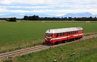
The NZR RM class Midland railcar was the first successful railcar, and first diesel-powered vehicle, to enter revenue service in New Zealand. Two were built, RM 20 and RM 21, and they ran for five years from 1936 to 1941 before being replaced by larger Vulcan railcars. They operated primarily on the Midland Line and the Greymouth-Hokitika portion of the Ross Branch

<span class="mw-page-title-main">Midland Line, New Zealand</span>

The Midland line is a 212 km section of railway between Rolleston and Greymouth in the South Island of New Zealand. The line features five major bridges, five viaducts and 17 tunnels, the longest of which is the Otira tunnel. It is the route of the popular TranzAlpine passenger train.

The Kurow Branch was part of New Zealand's national rail network. In the North Otago region of the South Island, it was built in the 1870s to open up the land behind Oamaru for development, and closed in 1983.

The Rapahoe Branch is a branch line railway that forms part of New Zealand's national rail network and is located on the West Coast of the South Island. It has been operational since 1923 and was named the Rapahoe Industrial Line until 2011.

<span class="mw-page-title-main">Stillwater–Ngākawau Line</span> Railway line in New Zealand

The Stillwater Ngākawau Line (SNL), formerly the Stillwater–Westport Line (SWL) and the Ngakawau Branch, is a secondary main line, part of New Zealand's national rail network. It runs between Stillwater and Ngakawau via Westport on the West Coast of the South Island. It was one of the longest construction projects in New Zealand's history, with its first section opened in 1889 and the full line completed 1942.

<span class="mw-page-title-main">NZR RM class (Vulcan)</span>

The NZR RM class Vulcan railcars were operated by the New Zealand Government Railways (NZR) in the South Island of New Zealand. All New Zealand railcars are classified as RM , and this class derived their nomenclature from the name of the manufacturer, the Vulcan Foundry of Britain.

<span class="mw-page-title-main">Ruatapu, New Zealand</span> Place in West Coast, New Zealand

Ruatapu is a small town in the Westland District in the West Coast region of the South Island of New Zealand. The town's name stems from Ruatapu, a figure in Māori mythology. The town is located on a narrow strip of land between the Tasman Sea and Lake Mahinapua, a shallow lake that was originally a coastal lagoon. State Highway 6 runs through Ruatapu, connecting it to the nearby towns of Hokitika and Ross. The town's economy is based upon agriculture, as well as a large sawmill, operated by Westco Lagan, which mills Radiata Pine for further processing in Christchurch.

<span class="mw-page-title-main">Lake Mahinapua</span> Lake in New Zealand

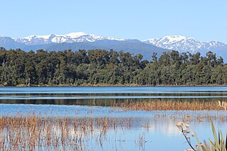
Lake Mahinapua is a shallow lake on the West Coast of New Zealand's South Island. Once a lagoon at the mouth of the Hokitika River, it became a lake when the river shifted its course. Lake Māhinapua was the site of a significant battle between Ngāi Tahu and Ngāti Wairangi Māori, and is regarded by them as a sacred site where swimming and fishing are prohibited. In European times it was part of an inland waterway that carried timber and settlers between Hokitika and Ross until the building of the railway. Today it is protected as a scenic reserve for boating, camping, and hiking.

The Rewanui Branch, sometimes referred to as the Rewanui Incline and known as the Point Elizabeth Branch in its early years, was a branch line railway located in the West Coast region of New Zealand's South Island. It branched from the Midland Line near its western terminus in Greymouth and ran up to Rewanui in the Paparoa Ranges. The branch closed in 1985 but the first six kilometres to Runanga remain in operation as part of the Rapahoe Branch.

<span class="mw-page-title-main">State Highway 73 (New Zealand)</span> Road in New Zealand

State Highway 73 is a major east-west South Island state highway in New Zealand connecting Christchurch on the east coast with Cass/Hokitika via the Southern Alps. It is mostly two lane, with some single-lane bridges north of Springfield but is mostly dual carriageway in Christchurch. The fourth and fifth-highest points of New Zealand's state highway network are on this road at Porters Pass and Arthur's Pass respectively.

<span class="mw-page-title-main">Westland County</span> Provinces of New Zealand in South Island

Westland County, also known as County of Westland, was a local government area on the West Coast of New Zealand's South Island. It existed from 1868 to 1873, and then from 1876 until 1989. In its first incarnation it constituted the government for the area that was split from the Canterbury Province, with the West Coast Gold Rush having given the impetus for that split. It had the same administrative powers as a provincial council, but the legislative power rested with Parliament in Wellington. The first Westland County was the predecessor to Westland Province.

<span class="mw-page-title-main">West Coast Wilderness Trail</span>

The West Coast Wilderness Trail has been funded as one of the projects of the New Zealand Cycle Trail. Once complete, the 139 kilometres (86 mi) track will connect Greymouth in the north with Ross in the south. Currently, the section from Greymouth to Hokitika is open.

References

Citations

  1. "Hokitika Line". Land Information New Zealand. Archived from the original on 25 October 2014.
  2. 1 2 3 4 5 6 Churchman & Hurst 2001, p. 193.
  3. 1 2 3 4 5 Leitch & Scott 1995, p. 60.
  4. William Hall-Jones, "The Public Works Statement", Otago Witness (24 September 1902), 28.
  5. "HOKITIKA AND GREYMOUTH RAILWAY COMMITTEE (REPORT OF, TOGETHER WITH MINUTES OF PROCEEDINGS AND EVIDENCE)". 1879. p. 6.
  6. "The Dense Forests and Snow-Fed Streams of the West: Ross to Wanaka via the Haast Pass", Otago Witness (24 January 1906), 57.
  7. "PUBLIC WORKS STATEMENT". Papers Past. 16 October 1911. pp. vii–viii. Retrieved 2 January 2023.
  8. "Railways Authorization Act 1911". New Zealand Legal Information Institute. p. 2. Retrieved 2 January 2023.
  9. "PUBLIC PETITIONS A TO L COMMITTEE (REPORTS OF THE). (Mr. ESCOTT, Chairman.), Appendix to the Journals of the House of Representatives, 1915 Session I, I-01". Paperspast. p. 4. Retrieved 2 January 2023.
  10. West Coast Times (18 February 1916). "THE MIKONUI BRIDGE". p. 4. Retrieved 2 January 2023.
  11. John Yonge, New Zealand Railway and Tramway Atlas, fourth edition (Essex: Quail Map Company, 1993), 22.
  12. "New Zealand Railways". West Coast Times. 26 June 1906. p. 2. Retrieved 13 June 2016.
  13. Pahiatua Railcar Society, "Early New Zealand Railcars" Archived 7 August 2011 at the Wayback Machine , accessed 4 November 2007.
  14. Leitch & Scott 1995, p. 61.
  15. Petchey, Peter (January 2007). Arahura Road/Rail Bridge (Bridge 28 Hokitika Line), New Zealand. Archaeological Assessment (Report).
  16. Toll Rail, Working timetable, effective 17 June 2007, accessed 4 November 2007.
  17. "New road bridge across Taramakau River completed". www.nzta.govt.nz. Retrieved 20 October 2018.
  18. Leitch & Scott 1995, p. 63.
  19. Greymouth to Ross Track Ground Effect, March 2010
  20. Victory Alluvial Gold Project, Superior Mining, November 2009
  21. Midland Line - Other Lines NZ Rail Maps website, May 2010
  22. "West Coast Wilderness Trail Official Opening |NZ Cycle Trail". nzcycletrail.com. Archived from the original on 31 May 2016.

Bibliography

  • Churchman, Geoffrey B; Hurst, Tony (2001) [1990, 1991]. The Railways of New Zealand: A Journey through History (Second ed.). Transpress New Zealand. ISBN   0-908876-20-3.
  • Leitch, David; Scott, Brian (1995). Exploring New Zealand's Ghost Railways (1998 ed.). Wellington: Grantham House. ISBN   1-86934-048-5.
  • Mulligan, Barbara (2000). New Zealand Rail Trails: A Guide to 42 Ghost Lines. Wellington: Grantham House Publishing. pp. 94–97. ISBN   978-1-86934-126-8.