State Highway 6 (New Zealand)

Last updated

State Highway 6 NZ.svg
State Highway 6
NZ-SH6 map.png
Route information
Maintained by NZ Transport Agency
Length1,162 km (722 mi)
Tourist
routes
Southern Scenic Route Southern scenic route NZ marker.jpg between Invercargill-Lorneville and Five Rivers-Queenstown (as of 2010)
Major junctions
North endState Highway 1 NZ.svg SH 1 (Grove Road/Sinclair Street) at Blenheim
Major intersectionsState Highway 7 NZ.svg SH 7 (Omoto Road) at Greymouth
State Highway 8a NZ.svgState Highway 8 NZ.svg SH 8A (Shortcut Road) to SH 8 at Luggate
State Highway 8b NZ.svgState Highway 8 NZ.svg SH 8B to SH 8 at Cromwell
South endState Highway 1 NZ.svg SH 1 (Tay Street/Clyde Street) at Invercargill
Location
Country New Zealand
Primary
destinations
Nelson, Murchison, Inangahua Junction, Runanga, Greymouth, Hokitika, Haast, Wānaka, Cromwell, Queenstown, Lumsden, Winton
Highway system
State Highway 5 NZ.svg SH 5 State Highway 7 NZ.svg SH 7

State Highway 6 (SH 6) is a major New Zealand state highway. It extends from the Marlborough region in the northeastern corner of the South Island across the top of the island, then down the length of the island, initially along the West Coast and then across the Southern Alps through inland Otago and finally across the Southland Plains to the island's south coast. Distances are measured from north to south.

Contents

The highway is the longest single highway in the country, though it is shorter than the combined totals of the two highways that comprise SH 1, SHs 1N and 1S.

For most of its length SH6 is a two-lane single carriageway, except for 5.4 km of dual carriageway in Invercargill, and passing lanes in Invercargill and Nelson, with at-grade intersections and property accesses, both in rural and urban areas. Roundabouts are common in major towns, with traffic signals only found in Invercargill, Queenstown, Richmond, and Tāhunanui with signals also controlling Iron Bridge in the upper Buller Gorge, Fern Arch in the lower Buller Gorge near Westport, and the Albert Town Bridge over the Clutha River near Albert Town. NZTA classified the highway as an arterial route, except for two sections between Blenheim (SH 1) and Richmond (SH 60) and between Cromwell (SH 8B) and Five Rivers (SH 97) where SH 6 is classified as a regional strategic route. [1]

Route

Marlborough

State Highway 6 crossing the Pelorus River in Marlborough Pelorus Bridge 001.JPG
State Highway 6 crossing the Pelorus River in Marlborough

The highway leaves State Highway 1 at Blenheim, initially travelling west through Woodboune to Renwick. At Renwick the highway turns north, crossing the Wairau River and following the Kaituna River valley to meet Pelorus Sound/Te Hoiere at Havelock. From Havelock, the highway heads inland up the valley of the Pelorus River. At Pelorus Bridge the highway again turns north through Rai Valley, and crosses into Nelson region at the Rai Saddle.

Nelson-Tasman

The highway then tends southwest as it crosses over the Whangamoa Saddle approaching the coast of Tasman Bay / Te Tai-o-Aorere. The highway travels through the city of Nelson and nearby town of Richmond, continuing southwest across the plains of the Wairoa and Motueka Rivers.

From these plains, the road ascends rapidly to the 634-metre Hope Saddle. From here, the highway heads generally westward, along the valley of the Buller River and its tributaries. Beyond Murchison, this valley narrows to become the scenic Buller Gorge, and the highway twists its way high above the waters of the river.

West Coast

"Hawks Crag", a half-tunnel of a rock shelf carrying State Highway 6 along the bank of the Buller River Buller River Hawks Crag 002.JPG
"Hawks Crag", a half-tunnel of a rock shelf carrying State Highway 6 along the bank of the Buller River
State Highway 6 near Kumara Junction. SH6 near Kumara Junction.jpg
State Highway 6 near Kumara Junction.

The highway leaves the river as its valley broadens, turning south six kilometres from Westport, where the river reaches the sea. From here, the highway keeps close to the Tasman coast from Charleston for over 100 kilometres, turning inland only briefly near Runanga. This 100-kilometre stretch includes two of the coast's larger towns, Greymouth and Hokitika.

From Hokitika, the highway moves away from the coast, though still generally keeps within five kilometres of the sea. The highway continues south past Ross and Harihari, moving through state forests as it crosses several fast-moving rivers. Seventy kilometres south of Harihari, the highway skirts Lake Mapourika and reaches the tourist settlement of Franz Josef Glacier. The glacier itself, one of two within easy walking distance of the highway, lies nearby in the Southern Alps, which here come very close to the Tasman coast. The second glacier, Fox Glacier is located some 20 kilometres further south. The highway again briefly touches the coast at Bruce Bay before heading inland past Lake Paringa, before reemerging on the Tasman coast at Knights Point. The 30 km stretch of highway from here south to Haast is noted for its rugged scenery. After crossing the Haast River, the highway turns eastward and inland up the river's valley, climbing past the Gates of Haast and crossing the 563-metre Haast Pass, the southernmost of the three main road passes across the Southern Alps.

Otago

From here, the highway again turns south, following the Makarora River valley to the northern tip of Lake Wānaka. The highway skirts the eastern coast of the lake before crossing The Neck, a saddle in the mountains that lie between Lakes Wānaka and Hāwea. The highway continues along the western shore of Hāwea, then south along the Cardrona River to Albert Town, close to the tourist centre of Wānaka.

State Highway 6 at the Nevis Bluff. NevisBluff.jpg
State Highway 6 at the Nevis Bluff.
State Highway 6 skirts the slopes of The Remarkables and shore of Lake Wakatipu south of Queenstown. NZSH6Remarkables.jpg
State Highway 6 skirts the slopes of The Remarkables and shore of Lake Wakatipu south of Queenstown.

Ten kilometres from Wānaka, the highway is met by SH 8A, a spur of SH 8 skirting the shore of Lake Dunstan. SH 6 continues south along the western shore of the Lake, paralleling SH 8 which lies on the eastern shore. Close to Cromwell, a second spur, SH 8B, connects the two highways. From here, SH6 turns west, following the narrow and twisting Kawarau Gorge, emerging close to the wine-producing area of Gibbston.

At the western end of the Kawarau Gorge, midway between Cromwell and Queenstown, the highway passes the Nevis Bluff, a steep schist rock outcrop rising 100 m above the Kawarau River. The highway has a history of being disrupted and closed at this point due to instability and rock falls from the bluff. The first road around the bluff was constructed in 1866, opening access to the Wakatipu goldfields. [2] Significant slips occurred at the bluff on 1940-02-20, [3] and blocking SH6 in June 1975. [4] On 17 September 2000, a large-scale rock fall buried the highway at the bluff, and several motorists narrowly avoided being killed. The fall was caught on video and showed a volume of 10,000 m³ for the main fall; the resulting dust cloud was seen 5 km away. [5] [6] Transit New Zealand conducted stabilisation drilling and blasting at the bluff twice in 2006 and again in 2007. [7]

From the Nevis Bluff, the highway continues west, reaching Frankton, close to the shore of Lake Wakatipu. The highway turns south to follow the southeastern shore of the lake, skirting the foot of The Remarkables and the Hector Mountains. This stretch of the highway is in part tortuously winding, and rises and falls over a stretch known as "The Devil's Staircase".

Southland

The highway leaves the lake's shore at Kingston, continuing south to Garston, where, the highway briefly follows the course of the infant Mataura River before heading across the Jollies Hill Pass to the upper reaches of the Ōreti River near Lowther. The highway continues to follow the Ōreti south, through Lumsden, then across the Southland Plains, past the town of Winton before reaching its terminus at a junction with SH 1 in central Invercargill.

Spur sections

SH6 has one spur, designated State Highway 6a NZ.svg State Highway 6A (also part of the Southern scenic route NZ marker.jpg Southern Scenic Route). This 6.9 km highway links Frankton with the tourist centre of Queenstown.

Engineering features

The Kawarau River Bridge on State Highway 6 Kawarau River Bridge.tif
The Kawarau River Bridge on State Highway 6

Route changes

SH 6 in Nelson City previously went through Stoke between Annesbrook Drive and the Richmond Deviation via Main Road. In 2003, SH 6 shifted to the newly constructed Whakatu Drive, bypassing much of the residential areas. [12]

Major junctions

Territorial authority LocationkmmiDestinationsNotes
Marlborough District Blenheim 00.0State Highway 1 NZ.svgFerry Sign.svg SH 1 north (Grove Road) – Picton, Wellington Ferry
State Highway 1 NZ.svg SH 1 south (Grove Road) – Kaikōura, Christchurch
SH 6 begins
Renwick 106.2State Highway 63 NZ.svg SH 63St Arnaud, Westport
148.7State Highway 62 NZ.svg SH 62 (Rapaura Road) – Picton
Nelson City
No major junctions
Tasman District Richmond 12980State Highway 60 NZ.svg SH 60 (Appleby Highway) – Motueka, Collingwood
Kohatu169105Motueka Valley Highway – Tapawera, Motueka Former SH 61
 196122 Hope Saddle 634 m (2,080 ft)
Kawatiri209130State Highway 63 NZ.svg SH 63St Arnaud, Picton
Ariki255158State Highway 65 NZ.svg SH 65Springs Junction, Christchurch (via Lewis Pass
Buller District Inangahua Junction 297185State Highway 69 NZ.svg SH 69Reefton, Greymouth, Christchurch (via Lewis Pass)
Westport 328204State Highway 67 NZ.svg SH 67 – Westport, Karamea
Grey District Greymouth 430270State Highway 7 NZ.svg SH 7 (Omoto Road) – Reefton, Nelson, Christchurch (via Lewis Pass)
Westland District Kumara Junction 448278State Highway 73 NZ.svg SH 73 (Otira Highway) – Arthur's Pass, Christchurch
Westland District / Queenstown-Lakes District boundary Mount Aspiring National Park 815506 Haast Pass 564 m (1,850 ft)
Queenstown-Lakes District Mt Iron893555State Highway 84 NZ.svg SH 84 (Wanaka Luggate Highway) – Wānaka
Luggate901560State Highway 8a NZ.svgState Highway 8 NZ.svg SH 8A (Shortcut Road) to SH 8Omarama, Aoraki / Mount Cook, Christchurch
Central Otago District Cromwell 942585State Highway 8b NZ.svgState Highway 8 NZ.svg SH 8B to SH 8 – Cromwell, Aoraki / Mount Cook, Dunedin, Christchurch
Queenstown-Lakes District Arrow Junction983611 Crown Range RoadCardrona, Wānaka Former SH 89
Frankton 996619State Highway 6a NZ.svg SH 6A (Frankton Road) – Queenstown
Southland District Five Rivers1,082672State Highway 97 NZ.svg SH 97 (Mossburn Five Rivers Road) – Te Anau, Milford Sound/Piopiotahi
Lumsden 1,093679State Highway 94 NZ.svg SH 94 west (Mossburn Lumsden Highway) – Te Anau, Milford Sound/Piopiotahi SH 6/SH 94 concurrency begins
1,095680State Highway 94 NZ.svg SH 94 west (Flora Road) – Gore SH 6/SH 94 concurrency ends
Winton 1,143710State Highway 96 NZ.svg SH 96 west (Winton Wreys Bush Highway) – Nightcaps, Ohai SH 6/SH 96 concurrency begins
1,145711State Highway 96 NZ.svg SH 96 east (Winton Hedgehope Highway) – Mataura SH 6/SH 96 concurrency ends
Invercargill City Lorneville 1,168726State Highway 98 NZ.svg SH 98 (Lorne Dacre Road) – Dacre, Gore
State Highway 99 NZ.svg SH 99 (Wallacetown Lorneville Highway) – Riverton/Aparima, Tuatapere
Invercargill city centre1,176731State Highway 1 NZ.svg SH 1 north (Tay Street) – Gore, Dunedin
State Highway 1 NZ.svg SH 1 south (Clyde Street) – Bluff
SH 6 ends

See also

Related Research Articles

<span class="mw-page-title-main">Queenstown, New Zealand</span> Resort town in New Zealands South Island

Queenstown is a resort town in Otago in the south-west of New Zealand's South Island. It has an urban population of 29,000.

<span class="mw-page-title-main">Clutha River</span> River in the South Island of New Zealand

The Clutha River is the second longest river in New Zealand and the longest in the South Island. It flows south-southeast 338 kilometres (210 mi) through Central and South Otago from Lake Wānaka in the Southern Alps to the Pacific Ocean, 75 kilometres (47 mi) south west of Dunedin. It is the highest volume river in New Zealand, and the swiftest, with a catchment of 21,000 square kilometres (8,100 sq mi), discharging a mean flow of 614 cubic metres per second (21,700 cu ft/s). The river is known for its scenery, gold-rush history, and swift turquoise waters. A river conservation group, the Clutha Mata-Au River Parkway Group, is working to establish a regional river parkway, with a trail, along the entire river corridor.

<span class="mw-page-title-main">Lake Wānaka</span> Lake in Otago, New Zealand

Lake Wānaka is New Zealand's fourth-largest lake and the seat of the town of Wānaka in the Otago region. The lake is 278 meters above sea level, covers 192 km2 (74 sq mi), and is more than 300 m (980 ft) deep.

<span class="mw-page-title-main">Haast Pass</span> Mountain pass

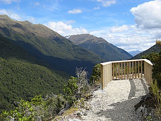
Haast Pass / Tioripatea is a mountain pass in the Southern Alps of the South Island of New Zealand. Māori used the pass in pre-European times.

<span class="mw-page-title-main">Kawarau River</span> River in the South Island of New Zealand

The Kawarau River is a river in the South Island of New Zealand. It drains Lake Wakatipu in northwestern Otago via the lake's Frankton Arm. The river flows generally eastwards for about 60 kilometres (37 mi) and passes through the steep Kawarau Gorge until it joins Lake Dunstan near Cromwell. Before the construction of the Clyde High Dam, the Kawarau joined the Clutha River / Mata-Au in a spectacular confluence at Cromwell. The Shotover River enters the Kawarau from the north; the Nevis River enters it from the south. With many rapids and strong currents, the river can be dangerous and has claimed many lives. It is popular for bungy jumping and kayaking.

<span class="mw-page-title-main">Lake Hāwea</span> Lake in Otago Region, New Zealand

Lake Hāwea is New Zealand's ninth largest lake.

<span class="mw-page-title-main">State Highway 1 (New Zealand)</span> Road in New Zealand

State Highway 1 is the longest and most significant road in the New Zealand road network, running the length of both main islands. It appears on road maps as SH 1 and on road signs as a white number 1 on a red shield, but it has the official designations SH 1N in the North Island, SH 1S in the South Island.

<span class="mw-page-title-main">State Highway 8 (New Zealand)</span> Road in New Zealand

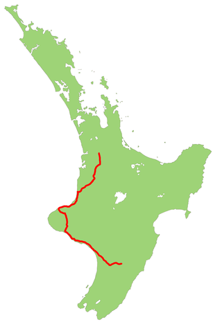
State Highway 8 is one of New Zealand's eight national highways. It forms an anticlockwise loop through the southern scenic regions of the Mackenzie Basin and Central Otago, starting and terminating in junctions with State Highway 1. Distances are measured from north to south.

<span class="mw-page-title-main">State Highway 3 (New Zealand)</span> Road in New Zealand

State Highway 3 (SH 3) is one of New Zealand's eight national state highways. It serves the west coast of the country's North Island and forms a link between State Highway 1 and State Highway 2. Distances are measured from north to south.

<span class="mw-page-title-main">State Highway 2 (New Zealand)</span> Road in New Zealand

State Highway 2 runs north–south through eastern parts of the North Island of New Zealand from the outskirts of Auckland to Wellington. It runs through Tauranga, Gisborne, Napier, Hastings and Masterton. It is the second-longest highway in the North Island, after State Highway 1, which runs the length of both of the country's main islands.

<span class="mw-page-title-main">Kawarau Gorge</span>

The Kawarau Gorge is a major river gorge created by the Kawarau River in Central Otago, in the South Island of New Zealand. The towns of Queenstown and Cromwell are linked by State Highway 6 through the gorge.

<span class="mw-page-title-main">Kawarau Gorge Suspension Bridge</span> Bridge in Otago

The Kawarau Gorge Suspension Bridge spans the Kawarau River in the Otago region in the South Island of New Zealand. The bridge is mainly used for commercial purposes by the AJ Hackett Bungy Company for bungy jumping - the world's first commercial bungy jumping site. The bridge carries walkers, runners and bikers on the Queenstown Trail over the river.

<span class="mw-page-title-main">Queenstown Trail</span>

The Queenstown Trail is a cycle and walking trail funded as one of the projects of the New Zealand Cycle Trail (NZCT) system in Otago, New Zealand. It links the towns of Queenstown, Arrowtown, the suburb of Jack's Point and the area of Gibbston. It is at least 110 km in length but is not linear and instead follows the terrain often near rivers and lakes to link key places in a series of tracks that also access public land. In some places it also passes through private land such as working farms and users are encouraged to stay on the trail. The trail is a joint venture between the Government, Queenstown Lakes District Council and the Queenstown Trails Trust.

<span class="mw-page-title-main">Gibbston</span> Community and wine region in Otago, New Zealand

Gibbston is a community in the Wakatipu Basin in the Otago region of the South Island, New Zealand. Through the valley runs the Kawarau River which forms the Kawarau Gorge.

<span class="mw-page-title-main">Kelvin Peninsula</span> Suburb of the town of Queenstown in the South Island of New Zealand

Kelvin Peninsula is a peninsula on the shore of Lake Wakatipu in New Zealand's Otago Region. The peninsula lies between the main body of Lake Wakatipu and the lake's Frankton Arm and its outlet, the Kawarau River. The centre of Queenstown lies on the opposite shore of the Frankton Arm. The peninsula was formerly called Kelvin Heights Peninsula. The name Kelvin Heights is still used for the Queenstown suburb which sits on the peninsula.

<span class="mw-page-title-main">Pleasant Flat</span> River flat in Haast Pass, New Zealand

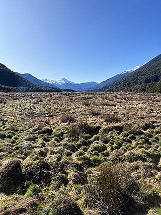
Pleasant Flat is an alluvial floodplain of the Haast River in the Haast Pass on New Zealand's South Island. A former stopping place for travellers crossing the pass before the building of the highway, it now has a campsite and picnic shelter. It has a notable view of Mount Hooker to the northeast.

References

  1. "One Network Road Classification: South Island State Highways" (PDF). New Zealand Transport Agency. Archived from the original (PDF) on 9 February 2016. Retrieved 6 March 2016.
  2. "Otago Goldfields Heritage Trail – Queenstown". New Zealand South. Archived from the original on 8 February 2012. Retrieved 8 May 2008.
  3. "Transactions and Proceedings of the Royal Society of New Zealand 1868–1961" . Retrieved 8 May 2008.
  4. Brown, Ian; Hittinger, Marc; Goodman, Richard (March 1980). "Finite element study of the Nevis Bluff (New Zealand) rock slope failure". Rock Mechanics and Rock Engineering. 12 (3–4): 231. Bibcode:1980RMFMR..12..231B. doi:10.1007/bf01251027. S2CID   129047444.
  5. "Motorists lucky to flee slip near Queenstown". The New Zealand Herald . 18 September 2000. Retrieved 8 May 2008.
  6. Hailliday, G.S.; McKelvey, R.J. (2004). "Video-analysis of an extremely rapid rockslope failure". Landslides: Evaluation and Stabilization. Taylor & Francis. p. 1355. ISBN   0-415-35665-2 . Retrieved 8 May 2008.
  7. "SH 6 Nevis Bluff ' Traffic Delays". Transit New Zealand. Archived from the original on 17 October 2008. Retrieved 8 May 2008.
  8. ca. 1900 photo of Hawk's Crag
  9. What is the longest bridge in New Zealand? Archived 19 June 2008 at the Wayback Machine , Transit New Zealand FAQs. Accessed 9 June 2008.
  10. "New two-lane Kawarau Falls Bridge project". NZTA.
  11. "Both traffic lanes of new Queenstown Kawarau Falls Bridge open Thursday". NZTA. 9 May 2018. Retrieved 12 May 2018.
  12. "Revoking Sections of State Highway and Declaring New Sections of State Highway". NZ Gazette. 11 December 2003. Retrieved 7 July 2016.